Read the full-length op-ed published in GIS Resources magazine. This version has been edited for length and clarity.
Bangladesh is a land-scarce country with a high-density population. As the majority of the population still lives in rural areas and depends on agricultural activities for their food and livelihoods, proper rural land management is critical to their well-being. However, land use changes and the impacts of climate change are rapidly reducing the amount of arable land, which has major implications for food production. Bangladesh requires an increased investment in sustainable land use planning to both increase economic growth and ensure food security for its growing population.
Since 2019, SERVIR Hindu Kush Himalaya, a joint project of NASA and USAID implemented by the International Centre for Integrated Mountain Development (ICIMOD), has provided technical support to Bangladesh to develop and use a national land cover monitoring system to track land cover changes across the country. The land cover monitoring system uses open-source satellite imagery to generate land cover maps annually. Bangladesh uses the land cover maps to monitor forest inventory and plans to expand to using them to strengthen sustainable rural land use planning.
Changing Rural Landscapes
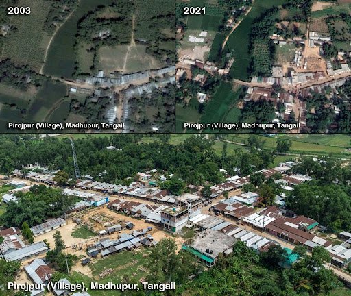
In villages across Bangladesh, human populations are expanding, creating greater demand for housing. To meet this demand, houses are now being built on fertile agricultural land, a limited resource. Restoring agricultural land or forest land is extremely difficult after it has been converted to other uses like housing.
Haphazard planning of rural dwellings negatively affects Bangladesh’s village ecosystems. Houses built on floodplains or canal banks cause stream bank erosion, flooding, and obstruction of water flow. Because village infrastructure cannot handle heavy rains, water accumulation causes flooding. The densely built areas also disrupt natural habitats and contribute to air and noise pollution. These risks are compounded by the impacts of climate change–Bangladesh is the seventh most affected country in the world by extreme weather events.
Detailed spatial land-use planning is critical to counter threats from changes in rural land use. Spatial land-use planning is a collective effort to develop and approve land-based activities. It provides a basis for the creation of zoning laws and defines specific uses of land that balance economic priorities with protecting the natural environment, strengthening living conditions, conserving natural resources, and promoting social cohesion. It requires up-to-date information on how land has changed over time, such as from forest to agriculture or agriculture to urban.
How Geospatial Technologies Help
Geospatial information is a critical component of land use planning and sustainable natural resource management. Geographic information systems (GIS) integrate diverse Earth observation imagery, spatial data (including land cover maps), and information on how human activities have historically affected and currently affect land use over time. GIS also makes it possible to project how anthropogenic environmental changes may affect land use and land cover in the future. It can be used to develop suitability maps for agricultural and infrastructure development by analyzing factors such as soil type, slope, water availability, and existing infrastructure.
Land use mapping and spatial planning allow decision makers to assess complex alternative development scenarios and model possible future changes, providing a basis for making informed, evidence-based decisions for rural land use.

As one of the world’s most flood-prone countries, Bangladesh also needs flood risk and flood shelter suitability maps for different climate change scenarios. Geospatial data provide decision makers the information they need to choose building sites that do not encroach on productive land, are not at risk of being submerged in floodwaters, and are reachable by human populations.
Appropriate and effective land use planning, implementation, and management can ensure rural development that is sustainable, environmentally sound, and strengthens food security. SERVIR is committed to ongoing collaboration with partners in Bangladesh to achieve these goals.
This blog was originally published on Climatelinks.


