Building Peace in the Diamond Mining Areas of the Central African Republic

USAID is strengthening the capacity of Central African Republic (CAR) government institutions to reduce long-standing tensions and conflicts in diamond mining areas such as Berberati.

Violent conflict in the southwestern Berberati region of the Central African Republic from 2013 to 2015 undermined the integrity of the diamond economy and sparked divisions leading to the erosion of trust between religious and ethnic groups, as well as between miners, farmers, and pastoralists. Rather than fueling local economic development, diamonds became a source of revenue for armed groups, who seized diamond mines and smuggled diamonds across borders in exchange for arms and ammunition.

In May 2015, the Bangui Forum, a national consultation, produced a peace accord calling for disarmament and reconciliation. In November 2017, the President of the Central African Republic, the honorable Faustin Archange Touadera, formally launched Peace and Reconciliation Committees in Berberati, an important milestone in translating this peace accord into concrete action in this diamond producing area.

A joint initiative by the Ministry of Social Affairs and National Reconciliation and the Ministry of Mines and Geology, these Peace and Reconciliation Committees will mediate disputes and forge agreements, or local pacts, to govern the use of coveted natural resources, like diamonds. USAID’s Property Rights and Artisanal Diamond Development Project (PRADD II) is assisting the government of CAR to develop a framework to guide this village-level peace and reconciliation process and is equipping these Peace Committees with the necessary skills to effectively mediate disputes between individuals and groups across ethnic and religious divides.

As a signatory to the Kimberley Process Certification Scheme, CAR is committed to reducing the flow of conflict diamonds. The peace and stability created through these pacts is critical to the country’s continued compliance with the Kimberley Process. By adhering to this international certification scheme, CAR can enjoy the economic benefits stemming from legally exported, conflict-free diamonds. Berberati is designated as a conflict-free mining zone, allowing the young men and women who depend on the mining to continue to mine and export diamonds legally. With USAID’s assistance, a region formerly known as a source for conflict is becoming a model for peace and the return of harmonious co-existence of peoples of different ethnicities, livelihoods, and religions.

IAEG-SDGs Upgrade Indicator 1.4.2 to Tier II Status

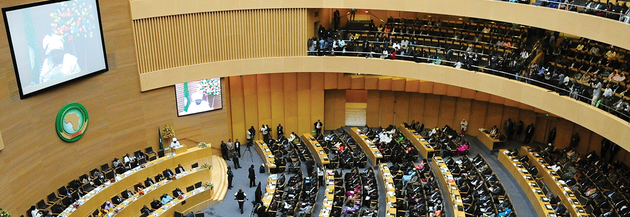
November 12, 2017, the 6th meeting of the Inter-agency and Expert Group on Sustainable Development Goal Indicators (IAEG-SDGs) reached a major decision to reclassify tenure security Indicator 1.4.2 from Tier III to II in Manama, Kingdom of Bahrain. This decision marks the beginning of a global journey to monitor tenure security for all, using comparable land indicators for globally comparable data. This decision followed a review by the IAEG-SDGs of progress made by the custodian agencies, UN-Habitat and World Bank, in the development of a robust, global methodology for monitoring the tenure security indicator 1.4.2, within the framework of SDGs. News of this decision was communicated by the IAEG-SDGs during its plenary session on 13th November, 2017 attended by representatives from countries, international and regional agencies and entities, and other stakeholders.

The IAEG-SDGs was established by the Statistical Commission at its 46th session to develop an indicator framework for the monitoring of the Goals and targets of the 2030 Agenda for sustainable development at the global level, and to support its implementation.

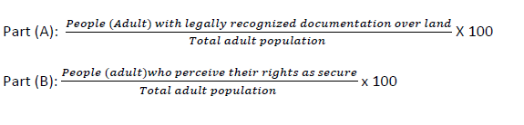
Indicator 1.4.2: “Proportion of total adult population with secure tenure rights to land, with legally recognized documentation and who perceive their rights to land as secure, by sex and by type of tenure”.

The proposed methodology for monitoring this indicator was developed through a rigorous and intensive consultation process involving the National Statistical Organisations (NSOs), National Land Agencies, data agencies (DHS, MICS, LSMS), regional statistics and land organisations, Civil Society Organisations and International Non-Governmental Organisations, private sector, the Global Donor Working Group on Land, UN agencies, and other stakeholders.

The now approved methodology gives equal value for legally documented tenure rights and perception of tenure security. This will advance the paradigm shift that aims to ensure over 2 billion people living in urban informality and indigenous communities’ territories will have their rights documented, accounted, and monitored for evidence-based policy decisions on the governance of their land.

The Formula: Monitoring Indicator 1.4.2

Towards Tier 1 Reclassification by 2019 Through Enhanced Local Action for Aata Collection: Country Capacity Challenge for Land Data Collection, Analysis, and Reporting

The next milestone now is to have at least 50% of all countries in all regions collect data and report regularly on Indicator. 1.4.2, which is a requirement by IAEG-SDGs for Tier I classification. With the Tier II reclassification, Custodian agencies can now move with speed to support country data generation initiatives towards this milestone. This will sustainably enhance countries’ capacity to collect and track progress on tenure security and measure progress on SDG 1 on Poverty Eradication under Target 1.4.

Based on the findings of a capacity assessment of 17 countries conducted by GLII / GLTN and UN-Habitat on NSOs preparedness to report on Indicator 1.4.2, data collection and reporting at scale is feasible and needs to integrate essential questions in existing national survey conducted by NSOs, standardization of data collection and reporting protocols for administrative data is also required. Since survey and administrative data are complementary, every country will collect the two data sets to monitor progress on this indicator.

As co-custodian agencies, UN-Habitat and the World Bank have developed several capacity development and awareness raising materials to support NSOs and National Land Agencies to realize this objective. Capacity strengthening for national and regional agencies in data collection, especially for developing countries, is expected to ‘leap-frog’ their ability to generate data and regularly report progress on this indicator to the UN Statistical Commission and to the UN High Level Political Forum.

The Funding Challenge

The reclassification of Indicator 1.4.2 confirms the global acceptability of the proposed methodology for data collection, analysis, and tracking of progress on tenure security at country level. This data will be generated and reported by the NSOs to the custodian agencies and UN Statistical Commission in collaboration with National Land Agencies and other stakeholders. The investment made by UN-Habitat and World Bank, the Global Donor Working Group on Land and GLTN through GLII with funding support from the Ministry of Foreign Affairs of the Netherlands, has not been in vain.

Technical and financial resources will be required to enable effective and efficient capacity building efforts at country level. While the reclassification decision is welcome, the lack of earmarked funding from to custodians and supporting entities like GLII is expected to challenge responsive planning for addressing capacity need from NSOs, National Land Agencies, CSOs, and other stakeholders. Joint strategy for capacity strengthening for Indicators 1.4.2 and 5.a.1 are being explored by the custodians, in collaboration with UNFAO, as a way to promote harmonization of these indicators, foster synergy, and apply a joint data collection questionnaire to generate survey data for these indicators.

The joint approach to capacity building and data collection for these two indicators is yet to be explored, and will certainly be a costly venture. Political goodwill and increased financial commitment from national governments to prioritize and support national efforts in land data generation and reporting will unlock great potential to achieve and surpass the 50% target of all countries by regions to achieve Tier I classification by end of 2019.

The role of private sector and donor community in supporting capacity development initiatives, data collection, new data technology transfer, awareness raising, and the convening of national and regional consultative meetings for sharing best practices in monitoring tenure security will enhance the level of success. Promotion of sustainable and country-led data initiatives will be key in fostering learning and building a knowledge based to support such efforts.

The Civil Society Organizations are also expected to play their key role in advocacy, awareness, and supporting local and national process for data generation by NSOs and National Land Agencies, while playing the watchdog’ role to ensure inclusivity; robustness of processes for data collection, including gender mainstreaming; and that no one is left behind.

Role of GLII in Supporting and Coordinating Land Governance Monitoring, Including the SDGs

For GLII platform members and partners, reclassification of Indicator 1.4.2 from Tier III to II is a well won outcome from months of lobbying, advocacy, collaboration, and intensive consultation. GLII platform members have fully supported and accompanied the custodian agencies in the development of the methodology for measuring tenure security, and view this reclassification as a great step in advancing GLII’s mission to achieve global monitoring of land governance at scale.

GLII’s work goes beyond the monitoring of land indicators in the SDGs to facilitate the integration of comprehensive and comparable land indicators for monitoring land governance at national, regional, and global monitoring efforts and programmes by various players. GLII will continue to support country, regional, and global capacity development initiatives on overall land governance monitoring, developing land indicators, methodology, and data protocols needed to support land governance monitoring. Read more about GLII on https://gltn.net/global-land-indicators-initiative-glii/

Blog submitted by: Everlyne Nairesiae, Coordinator, Global Land Indicators Initiative (GLII) Land and GLTN Unit at UN-Habitat.

USAID Seeks Investor Input for Survey on Land Rights

Last month, USAID launched the Land Investor Survey, which intends to establish and analyze a database on private sector perceptions of land tenure risks and costs. The project will reach out to potential survey respondents that might have land-based investments by facilitating two phases of data collection. The first phase is open and will be used to identify qualified companies or investors that meet the general screening criteria. All investors are invited to complete the initial 10-minute survey by November 30, 2017.

Clear, enforceable land rights are essential for land-based investments. Nonetheless, developing land-based projects in many parts of the world is often challenging because of uncertain land rights – for instance, even when a developer holds the legal right to develop a project on a certain piece of land, local people may be using that land for agriculture, pasture, shelter, water sources, etc. Their rights are rooted in customary tenure systems, and they may protest development of the energy project.

Through participation in this new investor survey on land, help us build the case that: (1) clear, secure land rights are paramount for land-based investments; (2) substantial sums are left on the table when investors don’t pursue projects because of uncertain land rights; and (3) investors incur significant costs if protest, conflict or other project delays or abandonment because of land issues arise. Also, (4) help us shine a light on successful investments that benefit local landholders.

Investors, please share your experience by completing our initial 10-minute survey by November 30, 2017. To access this survey, please click here or copy and paste the URL below into your internet browser: https://www.surveymonkey.com/r/LandInvestorSurvey.

Your individual responses are confidential and used solely for this project. The final report will report data in an aggregate form, with all identifiable information removed. The dataset will not be shared with the public.

If you have any questions, please contact survey@indufor-na.com. Thank you in advance for your participation!

The Business Case for Land Rights: You Asked, We Answered

USAID LandLinks hosted a webinar on “The Business Case for Land Rights: Private Sector Perspectives on Responsible Land-Based Investment” on November 2, 2017. Due to the high level of interest, there were more questions from the audience than we were able to answer. Our panelists, Jeff King (Hershey’s) and Olga Gormalova (ECOM Agroindustrial), took the time to answer some of the most interesting questions, which we share here:

Question: How do your approaches to land tenure affect women in cocoa communities—not only female-headed households, but women providing labor?

JEFF: We would advocate that these land-right changes would apply equally to both men and women, as women’s empowerment is a key tenant of CocoaAction. Many of the income diversification opportunities we help bring to these communities are targeted towards women.

Question: What concerns are women in cocoa communities voicing related to land tenure?

OLGA: Women face even more constraints when it comes to land ownership, many work on either plots that belong to their husband or husband’s family—hence in instances when the husband dies, the family of the husband can take over the farm without any benefit being passed on to the wife. There are various community based organizations that encourage husbands to legally assign a plot to the wife—if adopted, this would improve women’s land ownership rights.

Question: Do you know how many cocoa farms in Ghana do not have proper land tenure?

JEFF: This is very hard to estimate, as we are still collecting the data across our supply chain on the different types of land ownership to truly know the breakdown between owners of land and other forms of tenure. However, as discussed in the pilot documents, the laws are not favorable towards anyone trying to secure new land and are complicated should someone wish to sell land to another person. Additionally, the tree tenure laws (that the farmer does not actually have ownership of timber on their farm), act as a disincentive for farmers to plant shade trees which can help mitigate climate change, improves the yield of cocoa, and could act as a future revenue source for farmer.

OLGA: One resource that might address this question is the USAID Assessment of Land Tenure-Related Constraints to Cocoa Productivity in Ghana, which notes on page five that, “Land tenure in Ghana is governed by a pluralistic legal system, in which customary and statutory tenure systems overlap. Approximately 20 percent of land in Ghana is owned by the State, and governed by statutory law. The rest, approximately 80 percent of all land, is governed through customary tenure arrangements and vested in chiefs or other customary authorities. The vast majority of cocoa is farmed on customary land.” This is not to say that all customary land arrangements are not clear or undocumented, but a large portion of these arrangements is oral—hence insecure.

Question: I am here with a group of students. We are finding it a bit counter-intuitive that these businesses that rely on a steady supply of cocoa are encouraging crop and income diversification. Could this be a bit more explored or explained?

JEFF: The ultimate objective is to ensure cocoa farming as a prosperous and long-term viable business for the farmer, thereby securing the future of cocoa—of which you rightly indicate we all want to see a steady supply. Diversification provides a more stable business for the cocoa farmers in three primary ways:

  1. Steadier stream of income. Cocoa farmers get two harvests per year, one large and one small. This large period of time between harvests can create economic strain on the family. By having other sources of income, this revenue cycle is smoother between harvests.
  2. Mitigate the natural price movement in crop prices. All crops have natural movement in prices, this is no different for West African cocoa farming, vs. US corn or dairy farmers. By having multiple sources of income, farmers are not over-reliant on a single crop and will be less impacted by these natural price fluctuations.
  3. Greater participation by women in generating household income. Many of these income diversification opportunities are run by women. This increases the earning potential of the farming household, but also acts as a strong empowerment vehicle for the women in these communities.

Question: What were the insecurity issues and what are other lucrative income generating opportunities for farmers in this area of Ghana?

OLGA: The main issue is when the farmer knows that when he cuts down his aged cocoa farm, he will lose the right to that farm, or will have to renegotiate the arrangement, so many of the farmers opt not to cut the farm (40 percent of cocoa farms in Ghana are aged). There are opportunities for farmers in food crops like cabbage, tomatoes, rice and maize—but these are perishable crops and farmers need to look for markets (unlike cocoa which has a secure market—if you have cocoa beans then anyone can convert it into cash at any time).

Question: Could you please elaborate on what kind of adaptation/resilience plans Hershey’s is working on for cocoa farming and farmers in terms of changing climate?

JEFF: Hershey’s is working with the World Cocoa Foundation on the Climate Smart Cocoa program, which is a partnership between WCF members, USAID, and the governments of Cote d’Ivoire and Ghana, identifying and enabling methods to encourage farmers to utilize climate smart agricultural practices including zero deforestation. Additionally, Hershey’s is a signatory of the Cocoa & Forest Initiative, under which we are developing our company plans on how to support ensuring zero deforestation in cocoa including reforestation programs.

Question: What led to the shift from managing supply chains to managing farms and farmers? This presumably costs you more—are the benefits greater than the costs? Have you measured costs and benefits?

OLGA: ECOM has developed its new service of farm management and rehabilitation out of frustration that farmers were not adopting recommended practices we trained them on. So when we are questioned about impact (by our chocolate maker clients) it is very hard to show that adoption happens at farmer and farm level. The reasons why smallholders are not investing sufficiently in their existing plantations are varied and complex. The adoption issue is more complex than just lack of knowledge. One of the other key factors is limited ability of many smallholders to access credit (also due to lack of any land documentation). Chocolate makers are not traditionally used to financing these types of interventions, as they could instead be opportunities for businesses like micro-finance or agro-inputs dealers. Existing businesses do not seem to reach all the farmers, and since ECOM invested a long time in establishing a good primary procurement network, we wanted to use this as an opportunity—instead of just buying cocoa through the same channel, we developed various services for farmers.

At the beginning costs outweigh benefits, but over time if the business opportunities of working closer at the farm and farmer level is well developed—plus we tap into wealth of our knowledge—we believe our business will also be more sustainable and diversified.

A Century and a Half of Schooling

After 160 years, a land title has finally been secured for the parcel that houses the emblematic school of Santa Ana, located in Miranda, Cauca.

Originally appeared on Exposure.

LEARNING FROM THE PAST

The community of Santa Ana was founded 224 years ago and was the epicenter of what is today known as Miranda, a municipality in Northern Cauca. Its oldest institution is the school, which has been operating for 160 years on the same site.

In other words, when Colombia was just becoming a country—in the year 1857—leaders built the school and began providing instruction to the children of campesinos and Afro-Colombians. Following the abolition of slavery in 1851, many of the first families had escaped from the grip of ranchers in order to settle vacant lands and continue fighting for their freedom.

Today, the area is still home to descendants of these first families. For them, the school is a symbol of their history and their pride because it is where generation upon generation of mirandeños have received their education.

Over time, the administrative center and the county seat were transferred elsewhere, and Santa Ana became a village—one that in the complicated reality of Northern Cauca was able to resist the conflict. Although the community and the school’s administrators have made some improvements to the school over the years, the cracked walls of the old building suggest otherwise, and important renovations are required in order to ensure the well-being of the 115 children who go there for primary education.


USAID Launches New Learning Platform to Promote Land Technology Solutions

The USAID E3/Land and Urban Office recently launched the MAST Learning Platform, an interactive digital resource site that brings together tools, technical documentation, software code, demos, and lessons learned from the Mobile Applications to Secure Tenure (MAST) projects in Tanzania, Zambia, and Burkina Faso, as well as work performed under the three-year (2017-2020) USAID Land Technology Solutions (LTS) Project. The LTS Project, which is designed to refine MAST and support its expansion into new countries, offers USAID Missions and implementing partners a variety of tools and services. These include the design or support to land mapping activities and pilot projects, development of country-specific customized MAST technology solutions, or training to build mapping capacity at the local, regional, and national levels.

MAST LEARNING PLATFORM

The MAST Learning Platform is a knowledge portal that centralizes information, tools, lessons-learned, and best practices from existing MAST projects, as well as upcoming MAST activities under the LTS Project. Through the Learning Platform, users can access details and lessons learned from current or past MAST projects in Tanzania, Burkina Faso, and Zambia, as well as guides on how to use the MAST participatory approaches and technology. Users can also find information, access the MAST code, or even contribute to the MAST software development at the MAST software Github. The platform is a living resource and will feature regular updates and contributions from MAST users and projects.

Purpose of the MAST Learning Platform

  • The MAST Learning Platform is an interactive hub that provides a central, one-stop-shop for documentation, analysis, and resources from MAST projects in Tanzania, Burkina Faso, and Zambia, as well as upcoming new MAST projects to be implemented by the Land Technology Solutions Project and via other USAID programs.
  • The Learning Platform serves the broader development sector, as well as specific communities of practice, including USAID Missions and implementing partners. Users are invited to contribute information or posts or follow and attend upcoming events.
  • The resources on the platform make it easy for USAID Missions to integrate land or resource mapping into economic growth, value chain, market development, biodiversity conservation, women’s economic empowerment, and other programming.
  • The Platform contains tools, implementation guides, lessons-learned, case studies, video demonstrations and more, and is updated regularly with new offerings.
  • The platform features an interactive demonstration of the MAST application used in Tanzania so users can explore how the mobile application functions to inventory and document land information.
  • You can also access the software code or contribute to the software development through the MAST Software Github.

Benefits to USAID Missions of Using MAST

Using MAST participatory approaches and tools helps vulnerable populations clarify resource rights. In turn, this directly supports USAID strategic priorities outlined in the Global Food Security StrategyUSAID Gender Equality and Women’s Empowerment Policy, the USAID Biodiversity Policy, and more.

Unclear or insecure property rights contribute to conflict over land and natural resources and can undermine efforts to promote women’s empowerment, reduce poverty, develop markets, or strengthen agricultural value chains. This is particularly true where land governance is weak and demand for land from individuals, communities, companies, and governments has increased.

MAST in the Field: A Proven Approach and Easy-to-Use Technology

The MAST Learning Platform includes examples of how MAST has been used successfully in the field to map and register community and individual resources. In Burkina Faso, MAST improved the ease with which people and communities could record their land rights, reducing the potential for conflict over land. In Tanzania, the MAST community participatory mapping process helped identify and negotiate family land allocations, potentially avoiding or resolving lengthy family land disputes. Participants in the MAST process in Tanzania noted that they expected conflicts would decrease in the future because their land rights had been clarified and secured. For more examples, see MAST in the Field.

USAID LAND TECHNOLOGY SOLUTIONS (LTS) PROJECT: SERVICES FOR USAID MISSIONS

The LTS project offers services to USAID Missions and partners through integrated knowledge transfer, capacity building, and technical assistance. LTS is designed to enhance MAST and support its integration into new projects. LTS can help Missions integrate land and resource mapping into new project design or provide technical assistance to rapidly deploy pilot activities. LTS can also provide guidance in local customization of the MAST technology and tools. Please see the LTS Fact Sheet for more information.

Services Offered by the Land Technology Solutions (LTS) Project

  1. Guidance in the design of specialized land or resource mapping activities.
  2. Training and capacity building for host-country counterparts and USAID Mission staff.
  3. Technical guidance and needs assessments for the development of country-specific, customized versions of the MAST technology.
  4. Technical assistance to incorporate land or natural resource mapping into existing or upcoming programs.

To learn more: www.land-links.org/MAST or see the LTS Fact Sheet.

To coordinate LTS services, please contact Ioana Bouvier, USAID E3 Senior Geospatial Analyst and LTS Contracting Officer’s Representative (COR) at ibouvier@usaid.gov or Stephen Brooks, Alternative COR, at sbrooks@usaid.gov

USAID Land Champion: Harold Carey

Tell us about yourself.

I am the Private Sector Team Lead in USAID/Tanzania’s Economic Growth office. I manage a broad portfolio which includes, in addition to land, private enterprise development, investment, trade, access to finance, agribusiness, agriculture value chains and policy reforms related to each of these areas. Specific to land, I currently manage a land regularization contract named “Feed the Future Tanzania Land Tenure Assistance” Activity (LTA). This program seeks to: i) clarify and document land ownership; ii) increase local understanding of land use and land rights, and iii) support land use planning. The activity is currently mapping 250 rural land plots per day and will ultimately result in the documentation (digital and hard copy) of approximately 60,000 parcels for around 25,000 individuals in 41 villages.

I also coordinate USAID/Tanzania’s involvement with a randomized control trial impact evaluation (IE) that seeks to evaluate LTA’s land registration activities across five dimensions: 1) tenure security and land management; 2) land disputes; 3) investment and land use; 4) empowerment; and 5) economic and environmental outcomes. The IE fills an important information gap in that, while USAID and others have been exploring different approaches for documenting land ownership and sustainable land investment, there have been few rigorous evaluations of the impact of more formal approaches and outcomes from the formalization of customary tenure systems.

Furthermore, I directly engage with the Government of Tanzania through a variety of platforms for policy reform in an effort to provide input on changes to laws, acts, regulations, and procedures in the land sector, particularly around land registration and administration. This engagement is often conducted in unison with other development partners engaging on land issues in Tanzania including the World Bank, DFID, SIDA, DANIDA, FAO and a few local NGOs.

Why is land tenure/property rights important to your work at USAID?

I feel that land tenure security is essential for long-term, sustained economic growth. Not only does improved land tenure and property rights support broad-based, small scale investment, but it also facilitates better stewardship of the land, empowers disenfranchised groups, including women and youth, and is capable of solidifying land rights in a way that has the ability to significantly support conflict or dispute resolution. Each of these goals feature prominently in Tanzania’s Country Development and Cooperation Strategy and can benefit a segment of populations in developing countries which may otherwise turn to more nefarious pursuits if access to land in predominantly agriculture-based economies is not available for more productive endeavors.

What are some of the biggest challenges you see in addressing land tenure/property rights issues? And how are we tackling these challenges?

Perhaps the biggest challenge is the reality that there can be some very negative consequences for land reform interventions if not carefully thought out and implemented. Even the best-laid plans can fall apart due to government actions which are beyond the control of development partners, yet the reputation of the development partner is still in jeopardy if people are displaced, land-related conflicts erupt or land speculation drives costs to levels only available to elites. Development professionals engaging in the land sector should constantly keep this in mind and be aware of worrisome trends when they emerge. With this awareness, I find it best to reinforce the message that assistance is provided from the development partner to the responsible government unit, the District Land Office in our case, to deliver a public service that supports (positive and beneficial) national goals.

Another challenge is to overcome the opinion on the part of many that land registration, in and of itself, is a worthwhile pursuit. Mapping, demarcating, adjudicating and registering land is really only the first step in a much larger process. Developing a functional land administration system to which registered lands can feed into and be tracked as subsequent transactions involving those transactions take place should be the real goal. This can be a massive and off-putting endeavor on a national scale. However, it may be somewhat feasible to institute a sub-national (district) level land administration system, supported by transaction fees, as an example of something that could be scaled up over time as resources permit.

Finally, the idea that land registration and documentation automatically leads to increased tenure security needs to be challenged more often. It is the rule of law that backs up the certificate of registration or title that provides the tenure security, not the other way around. Each of these observations have obvious implications for any effort aimed at designing and implementing a land intervention.

What are some successes USAID has achieved in the land sector?

I designed and am currently implementing an activity that is demonstrating how to accomplish large-scale land use planning and registration at an affordable price (from $35/parcel to under $9), with high credibility and integrity, compliance with the law and in strong partnership with government at all levels. I feel particularly good about my direct negotiations with the Minister of Lands to change administrative procedures in a way that allows batch processing thereby greatly increasing cost efficiencies and allowing scalability. The activity itself will end up registering only about 60,000 parcels, but the tools, field procedures, public outreach materials and legal revisions allowing the batch processing of applications for customary title are already being adopted by another development partner initiative seeking the registration of about 250,000 parcels. The government of Tanzania is also adopting the tools and methodology outright for the small budgets they allocate each year to land regularization allowing them to increase their outcomes four-fold. Finally, the intervention package is being considered for use in a much larger land regularization activity within the country which may result in the registration of parcels for a significant percentage of Tanzania’s population.

Final thoughts?

Clearly define your goals, expectations, and theory of change prior to entering into land interventions. Identify your expected outcomes and set up systems to determine if and when you meet them. Most importantly, though, be constantly vigilant in watching for indications for the potential pitfalls of land regularization–land speculation, displacement of people, disenfranchisement, etc.

Also, kudos to the E3 Land and Urban Office for their significant efforts over the last two years to more effectively communicate to stakeholders across the board, internally and externally, regarding the value of land regularization. The efforts are noticeable and positive.

Launch of the African Land Policy Centre Heralds Better Governance of Land

Originally appeared on Africa Business Communities.

Eleven years since the establishment of the Land Policy Initiative, a ceremony was held in the presence of African Ministers and experts that launched the African Land Policy Centre (ALPC) in the margins of the second meeting of the AU Specialized Technical Committee (STC) on Agriculture, Rural Development, Water and Environment under the theme: “Enhancing environmental and agricultural transformation to achieve food and nutrition security in advancing Agenda 2063.”

Speaking at the launch, Josefa Sacko, AU Commissioner for Rural Economy and Agriculture welcomed the launch of the ALPC stating, “if the land is not well governed and sustainably managed we will not reach our set targets on increased agricultural productivity in accordance with the 2014 Malabo Declaration on Agriculture.”

“I strongly believe that our success in achieving the continent’s vision of transformed economies and prosperous Africans depends on our genuine ownership of targets, plans and actions towards this vision,” she said.

Ms. Sacko affirmed the decision by the Ministers attending the STC this week, who stressed that the African Land Policy Centre, “needs to be stronger in capacity and reach than the LPI, in order to support Member States to domesticate AU Decisions in their efforts to develop land policies, reform institutions and build land information systems to improve the governance of land.”

For his part, Stephen Karingi, Director of the Capacity Development Division at the ECA spoke on behalf of the Executive Secretary, Ms. Vera Songwe and said, the launch of the ALPC marks an important milestone in the implementation of the 2009 AU Declaration on Land Issues and Challenges in Africa, which called for the “establishment of an appropriate institutional framework to provide coordination of the follow-up activities and facilitate mutual learning by member states as they develop and review their land policies.”

“The African Land Policy Centre will serve as a means to strengthen and sustain Africa’s capacity to coordinate Member States and other actors in the implementation of the AU Declaration on Land Issues and Challenges,” he added.

Established in 2006 by the ECA, African Union Commission and the African Development Bank, the Secretariat of the Land Policy Initiative (LPI) has been hosted by the ECA with a small staff of experts charged with providing technical inputs on a number of initiatives, notably, the implementation of the AU Declaration on Land in accordance with the Framework and Guidelines on Land and other activities aimed at building evidence and reaching consensus towards improving land governance for economic and social transformation, improving environmental management and enhancing peace and security.

Between 2012 and 2013, the ECA provided technical input to the Secretariat as it led in consultations towards a study that produced recommendations to establish the Centre and presented to the inaugural African Union Specialized Technical Committee in 2015.

“Today, we are making an important step to implement the STC decision to establish and capacitate the African Land Policy Centre to provide leadership, coordination, build partnerships and promote policy advocacy in support of member states,” she said.

The Centre is expected to work closely with Member States to build sex-disaggregated databases to track commitments through the monitoring and evaluation of land governance in Africa beyond the 12 Member States currently implementing the Monitoring and Evaluation of Land in Africa (MELA) project – a pilot study to track progress in the implementation of the African Union Declaration on Land Issues and Challenges.

ALPC will continue the work begun by the LPI, such as strengthening capacities of universities through the Network on Land Governance in Africa (NELGA) to improve training, research and monitoring. In addition, following the endorsement by the STC this week of the Guidelines for the Development Curricula on Land Governance in Africa developed by the LPI, the ALPC will continue the work of improving the quality of land professionals to address Africa’s realities.

“Through land governance programmes in our Regional Economic Communities, we shall have a stronger mechanism to respond to Member States’ needs,” said Karingi.

The African Union’s STC concludes its work on Friday. It aims to review the relevant strategic goals and linkages in ongoing agriculture, rural development, water and environment related initiatives and their implications on the achievement of the overarching goals set out in the ten-year implementation plan of Africa’s Agenda 2063, to transform Africa.

Learn more at UNECA.

As Soon as a Ruling Comes In, We Know Who Should Do What

Q&A with Victims’ Liaison in the Municipality of Ataco, Tolima

Originally appeared on Exposure.

THE VICTIM’S NEEDS

What does your office do in the municipality of Ataco?

The Victims’ Liaison Office advises people in terms of their rights to petition, tutelas [writs for the protection of constitutional rights] and their rights as victims of the armed conflict. In addition, we manage humanitarian aid to victims and update their information in government systems. This work goes hand in hand with the monitoring of land restitution rulings and the verification of compliance with those rulings.

USAID is working with the government to better respond to and comply with restitution rulings. Have you seen any improvement in the capacity of the mayor’s office in this regard?

USAID helped us develop an internal management system. This system consists of building internal procedures so that as soon as a ruling is issued, we know who should do what. This enables us to handle information in an organized and coordinated manner.

How did you coordinate and organize responses before?

We were disorganized—there was no Transitional Justice Committee. Emails would arrive everywhere, and nobody knew who they were for or how to respond. USAID supported us in issues of institutional organization and helped us improve the Transitional Justice Committee. We have also received support in creating procedures for vulnerable populations, children, and people in unsafe situations to receive assistance. The president of the committee is the mayor, and all the institutions are present. They meet every two months, and a report that explains what has been done with the victims must be delivered.

One of the newly created subcommittees is that on land restitution. What is the role of this subcommittee?

We have restitution rulings backlogged since 2012. In Ataco, we have 213 sentences with more than 900 individual orders, which may involve more than 400 families, since each sentence has more than one verdict and sometimes affects several families. In fact, this is one of the reasons why it’s so difficult to handle information. The subcommittee manages the information and routes of compliance for the rulings. At our meetings, we check all those overdue judgments, follow the compliance routes that apply and collect the information.

A peace monument erected on the main plaza of Ataco's urban center. Photo: USAID Land & Rural Development Program
Señora Ángel Garzón has a restitution sentence and has received a restitution package. Photo: USAID Land & Rural Development Program
Life in the desolate mountains next to Ataco requires a lot of self-reliance. Photo: USAID Land & Rural Development Program
Lizeth Katherine Rayo, the Ataco municipality's victims' liaison. Photo: USAID Land & Rural Development Program.

PRIORITIZING RESTITUTION

How do you decide who responds to each ruling?

We look at co-responsibility. For example, these past two months we’ve had meetings with institutions such as courts, the governor’s office, SENA, the Land Restitution Unit and the Agrarian Bank. At these meetings we all have a discussion, and the municipality presents a report on what has been done by each institution, which allows us to see what problems exist and how to fix them.

With this strengthening of systems and organization, has the budgeting process for victims changed?

Yes. Last year, USAID helped us with the municipality’s Territorial Action Plan, from the collection of information to its creation. It was approved in December 2016. With this document, the municipality is able to better plan its care for victims. Assistance is now cross-sectional, and the municipality’s entire budget can be used for victim-related issues. The idea is for funds to be allocated to the population in general and at the same time to victims and vulnerable populations. The budget—more than 10 billion pesos between our own budget, transfers and royalties—has always existed, but it was not used the way it should have been.

So the mayor’s office had not added more money for victims, but instead has changed its approach to looking at restitution rulings?

Yes, exactly. We decided that we have one peso and we’ll split it between the communities of vulnerable people, victims and/or indigenous people. The municipality has always had the money, but it has never reported information as it should. This is what we started to do through our partnership with USAID.

Restitution rulings often require investment in infrastructure and the restoration of basic services. How have you strengthened the procedures for complying with orders of this magnitude?

The design of projects that respond to victims is very important, especially for tertiary road and agricultural projects. USAID is helping us determine which tertiary roads should be prioritized for the restituted population. At the same time, we have been trained to manage the platform and design projects. The road in the restituted area of Balsillas, about 33 kilometers long, will be the first investment of this type. The budget is big, but the contributions from the governor’s office and mayor’s office have already been identified. We’re still waiting for the contribution from the Ministry of Finance. The municipality is going to provide the operators and maintenance, while the governor’s office will provide a machinery kit. The whole process was facilitated and prepared by USAID.

USAID is facilitating a public-private partnership for cacao in Southern Tolima, and our intention is for the partnership to incorporate victims and beneficiaries of land restitution. How does your office help inform victims of these programs?

Most recently, we consulted restitution beneficiaries to see if they wanted to participate in the partnership and in an agriculture project related to cacao. Initially, four families in Ataco were considered due to the type of soil and the size of the property they own. We made sure that they were included, and every year the municipality is contributing 40 million pesos to the partnership for more than 400 cacao farmers in Ataco who are currently involved in the land restitution process or live in areas that will be restituted in the near future.

A coffee-farming family that remained that remained in their home during most of the violence. Photo by USAID Land & Rural Development Program.
A monument to the victims erected on the main road through the mountains of 7 de Agosto. Photo by USAID Land & Rural Development Program.
The road that was ordered to be paved by restitution judges. Photo by Land & Rural Development Program.
A coffee-farming family in Balsillas, high above Ataco's urban center. Photo by Land & Rural Development Program.

5 Ways USAID Will Support the Next 5 Years of the VGGT

This week, the global community celebrates the five-year anniversary of a landmark agreement: the Voluntary Guidelines on the Responsible Governance of Tenure (VGGT). These guidelines, which were unanimously endorsed by 96 countries in 2012, lay out globally-agreed best practices for strengthening land tenure and resource rights as a strategy to prevent conflict, empower women, and reduce food insecurity. The VGGT have been a catalyst in bringing the global community together around land tenure and property rights issues. The broad and inclusive participatory process of negotiating the VGGT has helped organize, focus, and sustain a wide coalition of stakeholders – including governments, businesses, civil society, and academia – working toward a common vision of improved land governance.

We are proud to count USAID among those stakeholders. From chairing the Working Group that negotiated the guidelines in 2012, to investing in research, innovative technologies, and capacity building programs, USAID has worked with our partners over the past five years to make the promise of the VGGT a reality for women, men, and communities around the world. Here are some of the highlights of what USAID has accomplished. As we look forward to the next five years of VGGT implementation, here are five areas of progress to look for from USAID:

  1. Donor coordination: Partnerships are essential for turning the recommendations of the VGGT into actionable policies and programs. USAID will continue partnering with donors and other stakeholders through the Global Donor Working Group on Land, and in other fora, to share knowledge, leverage partnerships, and amplify the reach of our investments. Learn more.
  2. Private sector partnerships: Weak land governance can undermine much-needed investment projects and threaten the rights and livelihoods of local communities. USAID will continue working with the business community to develop and test guidance on best practices, grounded in the VGGT, for making land-based investments more inclusive,sustainable, and less risky. Later this year, we will be sharing initial lessons learned from our partnerships with Hershey’s and ECOM Agroindustrial in the cocoa sector in Ghana and with Illovo Sugar in Mozambique. Learn more.
  3. Research, evaluations, and data: To turn the high-level recommendations of the VGGT into specific, measurable improvements on the ground, we need more evidence-based research and data on which strategies and methods are most effective and why. USAID will continue engaging in scientific evaluations and research, including randomized control trial impact evaluations, to critically examine the best approaches for strengthening tenure in a variety of contexts. Learn more and check out our latest research paper on forest tenure in Zambia.
  4. Urban tenure and integrated rural-urban approaches. The world is rapidly urbanizing. By 2030, 60 percent of the world’s population will live in urban areas, up from 30 percent in 1950. What happens in cities affects rural areas and vice versa – there is a strong correlation between urban economic growth and rural development. USAID will continue focusing on urban property rights, rural land tenure systems, and the connections between the two. We will be publishing new research and case studies on urban tenure later this year. Learn more.
  5. Innovations and technology. One of the most exciting ways USAID has supported the VGGT was through the development of the Mobile Applications to Secure Tenure (MAST) initiative. MAST is a suite of innovative technology tools and inclusive methods that use mobile devices and a participatory approach to efficiently, transparently, and affordably map and document land and resource rights. Building on successes in Burkina Faso, Tanzania, and Zambia, we recently launched a new program that will refine and expand MAST into more countries. Learn more.

We look forward to partnering with the rest of the development community to make the next five years of VGGT implementation as successful as the first five.

To learn more about USAID’s work on land governance and sustainable urbanization, visit: www.Land-Links.org and www.Urban-Links.org