Land and Conflict: You Asked, We Answered

On September 28, 2017 USAID held a Land and Conflict Webinar. It was a very engaged conversation, which meant that there were more questions from the audience than we were able to answer. Our panelists took the time to answer some of the most interesting questions, which we share here:

Question: Do you have successful stories about demarcation preventing, stopping or minimizing land conflicts? What are the effective mechanisms to enforce demarcation or delineated boundaries of Indigenous peoples’ lands from encroachment of corporations or third parties interested in the former’s lands?

Answer: We are supporting a pilot project which is demarcating communal areas in Afar and Oromia regions of Ethiopia. Negotiations between government and local communities took a very long time – they had to determine the size of land to be demarcated and type of land governance system to be established. While communities asked to restore and maintain traditional, larger-scale grazing systems, including customary institutions, government wanted the demarcation to be done at a small grazing unit level and keep management under formal government structures. Eventually, the government opened up to listen to communities’ interests and decided to allow traditional demarcation units to be managed by customary institutions, with technical and administration support by local authorities. As a result, both community representatives and local government officials reached to an agreement to proceed with the demarcation. We remain optimistic and hope to tell a success story of increased community land security once the demarcation is completed and recognized by government through issuance of a land use right title/certificate.
– Zemen Haddis

USAID has developed an Issues Brief on Tenure and Indigenous Peoples: The Importance Of Self-Determination, Territory, And Rights To Land And Other Natural Resources. The Issue Brief provides an overview of the key issues and includes recommendations for strategic interventions. Additionally, USAID/Ethiopia’s LAND project is working with indigenous pastoral communities to demarcate their lands and gain legal recognition of their pastoral community lands (see comment above). The Office of Land and Urban has an ongoing impact evaluation of this project to determine, among other factors, whether the demarcation reduces the incidence of encroachment by the private sector, government, or other actors, and if it reduces land conflicts. Similarly, in Liberia, USAID is evaluating [NGO] Namati’s Community Land Protection Program. That program includes boundary harmonization and demarcation, and community governance strengthening, in order to, among other things, empower communities to engage more effectively with external actors and reduce land conflicts. More information on these projects and ongoing impact evaluations is available on LandLinks.
– Kim Thompson

Question: I found this topic very interesting since in my country Ethiopia the dispute that has initiated from the conflict up a land boundary between Oromia regional State and Ethio-somali regional state, became very serious problem for evacuation & death of a lot of innocent civilians targeted based on their ethnicity (Oromo people & Somali living in Ethio-somali region and Oromia region). So what is your recommended strategic solution for this specific problem? We are in the middle of political crises where there is no transparency & accountability of federal & regional government leaders on resolving conflict rather than reporting false reports through public media ‘the conflict is ceased & no evacuation…’ even though the audience or community on the ground still suffering due to ongoing conflicts and thousands of evacuated people, I need to hear from you what should be done? Thank you!

Answer: ​I am not in a position to find out the causes of the recent conflict between Oromia and Somali regions in Ethiopia and provide a recommendation as a solution. ​I, however, can say that land remains at the center of many of conflicts occurring between different ethnic groups in Ethiopia. But it is good to note that land is not the only cause of conflict as there might be other triggering social, political and resilience factors.
– Zemen Haddis

Question: This is quite an important topic of discussion especially with the current state of conflict areas in Northern Nigeria. Not long ago I worked in a Land project (GEMS3) a DFID- funded program. This has really exposed me into understanding some land related issues in this part of the country especially the inequality issues that affect mainly the poor women and children. Do you have any Land and conflict related programs like the ones in Ethiopia and DRC here in Nigeria?

Answer: USAID is closely monitoring the conflict dynamics in Nigeria, including issues of displacement and land tenure. I am not aware of any current USAID programming specifically targeting land in Nigeria. However, the Office of Land & Urban is following with interest the Government of Nigeria’s plans to resettle those displaced by Boko Haram. Check out this overview of USAID programming in Nigeria.
– Kim Thompson

Question: As to the statement of Dr. Unruh: “Do not wait until war is over to address land & restitution issues – work with those affected ASAP” the concern about this view is that aid and relief agencies are quite particular of the “do no harm concept” of doing things. How can you reconcile this view [of yours] and the line of thought of aid and relief agencies from taking more proactive action on the ground due to the concept of do no harm concept?

Answer: Good question. By ‘do not wait to attend to HLP issues…’ we mean, begin to work with refugees and internally dislocated persons where they are dislocated, so as to begin to gather and organize their evidence that proves how they are attached to their HLP, so that when it is safe to return, they are able to quickly engage in an HLP restitution process. We do not intend to have people attempt to return to their HLP while the war is still underway, or have aid and relief agencies attempt to facilitate a return while the conflict is still underway. Only to work with ‘dislocatees’ while they are dislocated and where they are dislocated—ideally in a safe location.
– Jon Unruh

Question: What strategies are best suited for a society just emerging from an ethno-religious crisis as far as land matters are concerned?

Answer: Another good question. This can be a difficult scenario, particularly if forms of ethno-religious ‘cleansing’ has gone on, or other forms of demographic change has taken place, and divisions are ongoing, acute. Where there is willingness to engage in reconciliation, it can be productive to pursue this, but when there is reluctance to engage in reconciliation, options other than ‘going home’ should be considered by those that operate HLP restitution programs. HLP restitution program aims to do more than only assist people to regain their HLP. That is one option, but there are a variety of other remedies that can be offered when people are unable, or do not wish to return to areas of origin. These other remedies can include, compensation, alternative HLP in a new location, jobs, priority for development assistance, etc.
– Jon Unruh

Question: Have you seen any disproportionate impacts on women in the context of land and conflict in your region? What measures/provisions can be put in place to mitigate disproportionate gender impacts in the context of conflict?

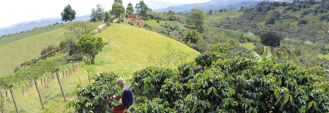
Answer: Conflict has certainly affected women differently than men. According to findings from a nationwide household survey published in 2012, 32% of households in Colombia are female-headed. For every 100 female-headed households, there are 86 male-headed households. For every 96 men displaced between 1985 and 2012, 100 women were. A study by UN Women indicates that 40% of displaced Colombian women have experienced gender-based violence.

Nearly 4 million women were displaced during the conflict in Colombia, many of whom had lived in consensual unions and lost their partners. In the process of returning to the land they lived and worked on with their partners, these women faced particular barriers in seeking to secure rights to the land they had been displaced from. Biases against women’s contributions to ‘working the land’ and lack of documentary proof of their union result in local authorities often disregarding their claims to land upon return. These biases also result in women being granted ownership rights to public lands they have occupied in good faith far less than men are. A 2015 study by the UN Women revealed that only 9% of land titles in Colombia are registered in women’s names.

The Colombian Government has taken important steps to address the disproportionate impact of the conflict on women and their access and rights to land. For example:

  1. In December 2015, a unit dedicated to addressing the issues encountered by rural women was created (Direccion de la Mujer Rural) within the Ministry of Agriculture and Rural Development. This unit is responsible for designing and evaluating rural development policies, plans and projects to ensure they will equitably deliver social and economic benefits to women; coordinating national and local government entities to deliver rural development and agricultural services to women; and to propose laws, instruments and procedures that will enable rural women to access public goods and services. This unit nevertheless operates with a small staff and budget.
  2. The Peace Accords signed between the Colombian Government and the FARC have established gender equality as a key principle framing the different provisions and processes to be implemented in the peace process, including comprehensive rural reform measures which prioritize women together with conflict victims. The accords call for women to be granted equal access to land with men and for women heads of household to be given priority for being given titles on public land and for delivery of subsidies for land purchases. Because the accords call for ‘comprehensive land access,’ this also includes gender-equitable access to housing, technical assistance, productive projects, and inputs, and prioritization of female household heads.
  3. As part of the Peace Agreements, Congress provided a path for laws designed to implement the peace accords to be ‘fast tracked.’ One of these was Decree 902 which sets out the provisions for implementation of systematic land tenure formalization and the creation of a Land Fund that would benefit landless and land poor households. This law, only very recently passed, takes the very crucial step of designating domestic and care work, which is traditionally performed by women, as constituting productive use of rural land, which is necessary to prove in order to be granted private property rights by the government on rural public land.

– Anna Knox

Question: You have mentioned that about 40% of land in Colombia is informal. What strategies and approaches has your project undertaken to deal with this? Land informality tends to create a lot of land insecurities for marginalized groups – often being women, non majority communities etc. Can you share good practices and approaches from your project in this regard?

Answer: The program has carried out a number of measures to support the formalization of land rights of women and ethnic minorities, among these:

  • Development of a systematic land tenure formalization methodology (the first of its kind being implemented in Colombia) that is highly inclusive of women and ethnic minorities (targeted communications of rights and the process, engagement in social cartography, engagement in adjudication, ensuring joint titling of couples, recognition of collective rights of ethnic groups, etc).
  • Carrying out policy research and provision of policy inputs that lower the barriers for women to claim their land rights;
  • Accompanying support for on-demand titling with communications campaigns that encourage women heads of household to secure formal titles and for couples to jointly register their land titles.
  • Working with municipal land offices to ensure joint titling of couples and prioritization of vulnerable women household head, as well as training local authorities in linking rural women to productive project opportunities and subsidies.

Although LRDP’s mandate did not include collective titling of ethnic territories (this was the mandate of another USAID program in Colombia), the program did target ethnic communities in specific restitution and rural development activities. Specifically, in restitution, the program developed a methodology to carrying out characterization studies for ethnic communities seeking to be restituted their collectively held territories. These studies draw on the narratives of communities to document their relationship with the land and natural resources and their experiences during the conflict of being deprived of that relationship, including oftentimes displacement. These studies comprise a central piece of evidence to support the restitution cases of ethnic communities.

In addition, the program has employed multiple measures to ensure women’s full participation in the restitution process, including:

  • Training lawyers preparing restitution cases to ensure female partners present themselves as co-applicants;
  • Supporting radio programs (radio-novelas) produced by women to educate other women about their rights to claim restitution and have their land titled in their names.
  • Conducting research on restitution sentences targeting women and provision of policy recommendations to enhance their gender differentiation and strengthen compliance of government entities in fulfilling those orders.
  • Provision of tools for public defenders to encourage women secondary occupants (those who settled on land in good faith during the conflict, land that is now being reclaimed by the original owners displaced from it) to seek legal support and compensation for losses they may incur in the land restitution process.

– Anna Knox

The Fight for Land

How the Land Restitution Unit, with the support of USAID, has made significant progress in preparing restitution claims for the indigenous Sikuani community

OLD LANDS, NEW SPACES

The historic fight for the territory of the Sikuani indigenous community, settled in the municipality of Puerto Gaitán, Meta, gained momentum over 20 years ago, when the Sikuani collectively called for the territory’s formal recognition. During Colombia’s armed conflict, this community was the victim of massacres, torture, negative impacts brought by illicit crops, threats, and accusations of being guerrilla sympathizers.

Emiliano Rodríguez García, 68, is one of the oldest leaders of the Sikuani community. He recalls that before the conflict, they led a quiet life. They could readily cross the rivers and creeks, and they were free to go about their lives. However, after illicit crops arrived in 1991, life in the indigenous community took an unexpected turn. In nearby areas, drug lords established major coca crops—up to 50 hectares—and forced children and women to harvest the leaves.

“Indigenous people fear war and death; we don’t want to be killed. That’s why we moved away, seeking safety in the woods, where no one would bother us. We left many lands unsold. These lands stayed vacant and others took them over,” says Rodríguez.

During that time, the Sikuani people were restricted from moving about their territory and lived in the stranglehold of guerrillas and paramilitaries. In addition, many of their young people were recruited by armed groups. These groups did not respect indigenous authorities, and their encroachment affected indigenous traditions and brought social problems such as drug addiction and alcoholism.

“With the demobilization of the paramilitaries, things began to change for the Sikuani. Before that, we were victimized for defending our territory from drug crops, and this turned us into the target of drug lords,” said the current Sikuani leader, Luis Enrique López.


USAID Land Champion: Sarah Lowery

Tell us about yourself.

I have worked on sustainable investment and innovative finance for over 12 years – first, as a Peace Corps Volunteer growing community-based businesses in Belize; then as a management consultant to organizations in the United States, Colombia, and Spain; then designing financial mechanisms to encourage deforestation-free investments in Brazil and Colombia; and now at USAID. Throughout my career, I repeatedly come across uncertain property rights as a major barrier to offering finance to many landholders. Thus, I was excited to jump squarely into this field two years ago when I joined the Office of Land and Urban.

I am currently leading research into the connection between stronger land tenure and access to finance and participation in land markets. We are adding to the body of evidence on these links, with data from our impact evaluations in Zambia. I also lead our office’s engagement with the private sector on responsible land-based investment, which includes pilots with Hershey’s, ECOM, Illovo Sugar, and the Moringa Partnership. Finally, I am thrilled to be launching a new investor survey on land-based risks, costs, foregone investments and mitigation strategies. These efforts will foster opportunities for American economic interests while bolstering land and resource rights for local people.

Why is land tenure/property rights important to your work at USAID?

Weak property rights is one of the most limiting factors to achieving USAID development objectives including economic growth, peace and security, and democratic governance. In fact, it is estimated that 70 percent of land is unregistered in the developing world.

How can we expect farmers to invest in better technology, irrigation infrastructure, mixed crop systems or other improvements if they are not certain they will have access to or control over the land next year or in ten years? How can we work with investors – from small business owners to multi-national companies – to enhance productivity, create new jobs, etc. when they are forced to spend scarce resources defending their infrastructure by building fences, employing security teams or defending court cases?

It is critical that our programs incorporate land and resource governance components in order to achieve USAID development objectives, guarantee the long-term sustainability of our interventions, and ideally, work us out of a job.

Many people think of land rights primarily in connection to agriculture and rural development. What is the connection between land tenure and property rights and other development issues, like responsible land-based investment?

Strong property rights are essential building blocks for all facets of sustainable development and all sectors. I cannot think of a single type of land-based investment for which clear and enforceable land rights is not paramount. For agriculture, land rights for family farmers or large plantations are both critical. In fact, we are currently working with Illovo Sugar to participatory map and document the land near their plantation in Mozambique so farmers’ confidence that their land will not be encroached upon by others increases and so the company knows how much sugar will be supplied to its mill in coming years. Likewise, documented rights to land is one of the most critical components of any energy investment decision – on par with a power purchase agreement. For forestry investments, often nothing moves forward unless land rights are 100 percent clear for the life of the project, which is usually at least eight or ten years, if not longer.

And this makes sense of course. But I want to point out that responsible land-based investments go beyond acquiring legal rights to develop land: they also respect the legitimate land and resource tenure rights of people who derive benefit from the land in or near proposed investment sites. That can include, for example, farmers, pastoralists, hunters and others who use the soil, water, trees, grasses and other resources for their economic, social, recreational or other purposes. Whether their rights are rooted in statutory law or customary governance systems, they are legitimate and should be respected by investors. And ideally, investments will be structured to not only do no harm to such persons but will also provide additional benefits to them.

What is the role of USAID’s E3/Land and Urban Office?

E3/Land and Urban plays a number of roles. First, we support USAID missions around the world and other operating units here in Washington to achieve development objectives by integrating land and resource tenure into programs. Second, we foster technological and other innovations in the land sector such as our Mobile Application to Secure Tenure to continue pushing the envelope on what’s possible in the land sector. Third, we are a leader in building the evidence base for effective land programming by conducting rigorous impact evaluations and performance evaluations of USAID and other land programs. Fourth, we communicate our research findings and that of our partners and other donors to USAID colleagues and the land community at large through our newsletters, blogs, media scans, Land-Links, etc. Fifth, we build the capacity of USAID to strengthen property rights via our Massive Open Online Course and other trainings.

What are some of your biggest accomplishments in the land sector?

I am most excited about the innovative, pioneering initiatives that we are leading to focus our approaches to strengthening land and resource rights.

For instance, we are launching an investor survey on land-based risks, costs, foregone investments, and mitigation strategies. The results of the survey will demonstrate how/if investors measure and price land-based risks in their pro formas and other analyses, quantify the costs of “projects gone wrong” as well as the value and location of foregone investments because of land issues, and present case studies of successful land-risk mitigation strategies. The survey report will be incredibly useful to (1) make the case to governments that clear, enforced land rights are essential to attract responsible investment, and (2) show investors that the responsible investment is both financially attractive and possible via case studies of successful land-based investments. Furthermore, this initiative will assist us in building productive partnerships with the private sector to increase responsible land-based investments that protect legitimate land rights and provide tangible benefits to local landholders.

Final thoughts?

People assume that land-based investments negatively impact local people but are worth these costs because of the larger development goals they hope to achieve – e.g., providing electricity to or growing food for thousands of people. However, I firmly believe that even large-scale land-based investments can help lift local people out of poverty by creating direct benefits to them, and we are working to uncover successful case studies of such projects. For example, Brookfield Renewables and the ‘Namgis First Nations tribe in British Columbia formed a joint venture to create a run-of-river hydroelectric project that generates revenue for the tribe via their ownership stake, finances their Community Benefit Fund, and gives them preferential employment opportunities. I love talking about this project in particular because the ‘Namgis stake was borrowed – in other words, the community did not put up the capital to develop the project; instead, they paid back their ownership stake via their returns once the project was up and running. This is a model that is theoretically feasible in any community or nation.

This project has been successful because the traditional land rights of the ‘Namgis were recognized and respected, the ‘Namgis were treated as a true partner in the development of the project, and their environmental and social concerns were heard and addressed. The project protects several salmon and trout species by, for instance, stopping to divert water when river flows would fall too low to support the fish population, and the project occasionally shuts down operations to allow for river recreation activities, such as white water rafting. My goal is for these kinds of win-win land-based investments to become the norm rather than the exception.

Request for Information: USAID/DRC’s Responsible Minerals Program Planning

The purpose of this Request for Information (RFI) is to collect written information about the capabilities and interest of all public and private parties in participating in a co-creation process1 to identify innovative solutions for the promotion of a responsible mineral trade (RMT) in eastern Democratic Republic of the Congo (DRC). The information will be used to help make planning decisions and influence activity design to improve future development outcomes and is published in accordance with Federal Acquisition Regulation (FAR) Part 10 and FAR 15.201(e).

This is an RFI, not a Request for Proposals (RFP), and is not to be construed as a commitment by the U.S. Government to issue any solicitation or ultimately award an agreement on the basis of this RFI, nor to pay for any information submitted as a result of this request, nor does it commit the Government to pay for costs incurred in the preparation and submission of any comments.

Any funding proposals submitted in response to this request will not be considered. Responses to this notice must be received by no later than the due date and time stated below in this notice. All information provided will become the property of the U.S. Agency for International Development (USAID), will not be returned, and will not be released publicly. USAID reserves the right to use information provided by respondents for USAID’s own purposes. Proprietary information must not be sent.

View the RFI here and instructions for responses here: RFI-SOL-AID-660-RFI-17-000001

How Mobile Applications are Documenting Property Rights in Zambia

Originally appeared on ICTworks.

There is a silent race running through developing countries around the world – a race for access to land and the knowledge of whom the land belongs. The race is not necessarily between people, or neighboring farmers, or even between government and their citizens, but exists at the nexus of productive livelihoods, and the sustainable stewardship of land each person calls home.

Globally, the livelihoods of literal billions of people rely on these factors – access to land for farming or mining and ownership and management of land. How these factors are addressed today will provide the foundation for long-term growth and confidence for people tomorrow.

The Zambian Context

With its large area, growing population, and governance combining centuries-old chiefdoms with a modern democracy, Zambia is particularly well suited for a convergence of old and new ideas regarding land tenure and security. Zambia has a very rough estimate of 15 million properties undocumented in its 75 million hectares.

Zambia’s land is divided between state land (eligible for leasehold titles) and customary land (largely rural). Customary land is administered by over 250 traditional chiefs, often, as mentioned before, with little documented evidence of ownership rights for individual households. As of 2013, there were fewer than 150,000 state leasehold titles issued by the government, which is less than one title per 100 individuals and approximately 1 title for every 5,300 hectares of land. In rural areas, only a few, but growing number of chiefs are issuing any sort of documentation of their land allocations.

The paper-based, signature heavy process being used to secure tenure is cumbersome and not readily or universally accessible to the people who need it. In fact, under the current system, it is estimated it would take over 1,000 years to document the country’s customary and state-held landholdings—an astounding number used only to make the point that there is much work to be done.

Read the full article on ICTworks.

Laying the Foundation: Land and Livelihoods

The integrated approach to land tenure that builds government capacity, strengthens economic development, and protects property rights.

Originally appeared on Exposure.

HEAVEN & EARTH

For the past ten years, Eloísa Garzón Ángel—a mother of six living in Potrerito, a lonely outpost in the arid mountains of Southern Tolima, near Ataco—has witnessed, during each election season, how local politicians drive up to visit the 250 families living in this conflict-ridden and forgotten corner of Colombia.

“They come up and promise us heaven and earth, but all anybody wants here is a paved road,” she explains.

The road, which was first excavated 30 years ago, played a strategic role in the military strategy of the Colombian leftist rebels known as the FARC, allowing them to transit and control a large swath of south-central Colombia between Meta and Tolima. Today the road mostly causes headaches for the estimated 1,000 people living in these mountains. The farmers and ranchers—who are dedicated to growing coffee on the steep hillsides and keeping cattle where they can—find it hard to compete, forced to pay such high costs to get their products to market.

Southern Tolima was always the FARC’s major stronghold near the rebel army’s birthplace. In the early nineties, the FARC started to canvas the mountains west of the urban center of Ataco before its official invasion in 1997. Two years later, the rebels attacked and controlled Ataco, sparking an ongoing battle for this and neighboring municipalities that would last more than a decade.

Between 2001 and 2007, most families in these mountains fled to cities as far as Bogotá to escape the violence. That is where Eloisa and her family went after leaving their farm, with very little on their backs. They spent four years struggling to find jobs and secure support from the complex government processes to assist displaced people.

“Leave everything you’ve created, everything you’ve made to go to a big city to suffer hunger and sleep on the floor is a sad solution for a displaced person,” she explains. “Life in Bogotá is expensive and you never stop spending money. It’s not like living in the countryside.”


Volunteers for International Security and Prosperity (VISP)

The VISP Annual Program Statement (APS) is designed to help USAID maximize its development impact by providing an easy to use, responsive mechanism that enables Missions to access expertise from a broad array of partners that can mobilize volunteers.

The APS seeks to help USAID maximize development impact, as well as promote efficient resource use, by mobilizing the creative capacity of volunteers globally. It also serves to fulfill the mandate of the Volunteers for Prosperity Executive Order, which tasks USAID with promoting, expanding, and enhancing volunteer service opportunities for highly skilled U.S. professionals who wish to work with non-governmental and voluntary service organizations around the world in support of major U.S. development initiatives.

This APS is an effective mechanism to facilitate access to skilled paid and volunteer expertise across any sector while supporting the U.S. foreign policy objectives of promoting national security, advancing American values, and supporting global prosperity and self-reliance. This global program will be funded and managed at the individual OU (Mission, Bureau or Independent Office) level.

How it Works

The VISP APS is not a Request for Applications or a Request for Proposals; it invites concept papers from a wide variety of non-governmental and voluntary service organizations for assistance awards that achieve development impact in USAID focus areas through the inclusion of volunteers.

Eligible organizations should contact USAID OUs to discuss their organization’s proposal. Following these discussions, the organization may submit a brief concept paper. Volunteers must comprise at least 30% of the total labor level of effort within any activity funded through the VISP APS. Based on their review of the concept paper, the USAID OU will make a decision whether to co-create the activity with the applicant and to request a full application. Acceptance of the concept paper satisfies competition requirements but does not guarantee an award.

Through the VISP APS, Missions can engage new organizations and non-traditional partners with specialized expertise. These new partners, and the opportunity to co-design solutions, allow for the generation of new ideas from people and organizations with fresh approaches. Peer-to-peer learning opportunities can also offer a way to build relationships between U.S. and local organizations that have the potential to live beyond the life of the development program. Missions can stretch development dollars and public diplomacy efforts by using the additional technical capacity provided by volunteers.

The flexibility of the mechanism and the opportunity for co-design adds another tool to the Mission toolbox for accessing specific expertise, paid and volunteer. Missions can also tailor programs to their specific needs by adding an addendum to the APS at any time. Addenda are brief descriptions of the problem the Mission is trying to solve and will be posted to grants.gov independently from the APS.

Contact

Local Sustainability Office (E3/LS)
Email: visp-aps@usaid.gov

Global Donor Working Group on Land Updates on the SDG Land Indicator 1.4.2

Donors’ data from land surveys to support methodology for 1.4.2

In June, the Friends of the Custodians (FoC) Committee collected data sets from land surveys conducted by donors agencies and shared them with the Custodians. The data comprised past evaluations and other surveys that have household/individual/parcel information, information about upcoming evaluations and countries where donors have close relations with the statistical agency or land/agricultural ministry to help advocate reporting on indicator 1.4.2. This info will help in the preparation of the methodology report to be submitted to the Inter-Agency Expert Group (IAEG) on SDG Indicators by 2 October 2017.

Highlights of July meetings

In July the Custodians held three important meetings:

3rd Expert Group Meeting: Using Administrative Data to Monitor SDG land (Barcelona, 6-7 July)

The focus of this EGM was on the indicator component “legally recognized documentation” which will be measured using administrative data produced by the land agencies in the different countries. Other components of the indicator will be measured using household survey data. Particularly, the objectives of this EGM were to: (1) agree on a methodology to monitor the part of indicator 1.4.2 pertaining to legally documented rights using administrative data, (2) assess availability of existing data and explore ways of institutionalizing reporting at country and regional level, and (3) explore options for building on administrative data to advocate and measure progress of land policy reforms. A readout from this EGM will be shared soon by the custodian agencies. The FoC had access to at least one presentation – by Klaus Deininger (WB) – on strategies for compiling administrative data – see the PPT here.

Expert Group Meeting on Women Land Rights (NY, 8-9 July)

This EGM examined land indicators in the SDGs, seeking for meaningful and more harmonised approaches to monitor women’s land rights in a coordinated manner at all levels. This EGM was convened by Global Land Indicators Initiative (GLII) in partnership with Oxfam. This EGM was particularly relevant for indicators 5.a.1 and 5.a.2 addressing women’s land rights, but also important to raise political support for 1.4.2. See the readout from this EGM here.

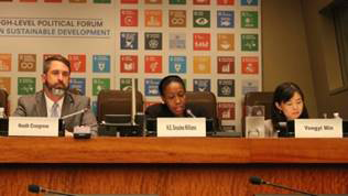
HLPF side event on Progress on Monitoring Tenure Security in SDGs – where are we? (NY, 10 July)

At this well-attended side-event, custodian agencies and partner organisations aimed at raising political support by UN Member States and other groups to globally monitor land governance through the SDG indicator 1.4.2.

Speakers included H.E. Ambassador Dessima Williams, Special Advisor to the President of the General Assembly of the United Nations on the Implementation of the SDGs, Heath Cosgrove, Director of the Land and Urban Department at USAID, Yongyi Min, Chief of Sustainable Development Goal Unit-IAEG, amongst others. They underscored the importance of securing land tenure to fight poverty and provided an update on the progress made in developing the methodology on indicator 1.4.2.

Amongst the participants’ recommendations for the ongoing process of developing a global methodology on indicator 1.4.2, are to support public education and raise awareness at the country level to the importance of monitoring tenure security and to promote capacity building for Land agencies and National Statistical Offices in new data production methods including surveys/earth observation.

Upcoming Meetings

  • 12 September, online: German NGO Welhungerhilfe will host a video conference to raise awareness of the German multi-stakeholder forum on land about the SDG land indicators. This multi-stakeholder forum comprises german government officials (Ministry of Development Cooperation, Ministry of Food and Agriculture), GIZ, NGOs and academia. Invited experts, such as Sven Kaumanns of the German Statistical commission (tbd) and Luca Miggiano from Oxfam-Novib, will inform about the importance of land tenure in the SDG context and share updates on the various land indicators – particularly the need to reclassify indicator 1.4.2 from Tier III to Tier II. Participation is by-invitation only. More info with Marion.Aberle@welthungerhilfe.de
  • 9-13 October, Rome, Italy: 44th Committee on World Food Security (CFS). This year the CFS is organizing a special plenary session on the SDGs. Countries will have the opportunity to share and discuss how they are implementing the Agenda 2030 and to reflect on the outcomes of the High-Level Political Forum 2017 to further implementation of the SDGs.
  • 11-14 November, Manama, Bahrain: 6th Meeting of the IAEG-SDGs, hosted by Bahrain Center for Strategic, International and Energy Studies (DERASAT). You can view the provisional agenda here, as well as further information here. The first two days (11 – 12 November) will be an exclusive IAEG-SDGs members meeting, while the final two days (13 – 14 November) are a plenary session, where countries non-members of the IAEG, international organizations and other stakeholders are welcome to attend.

To Effectively Reach a Population, We Need to Coordinate with All Institutions

Q&A with the Restitution Coordinator at the Superintendence of Notary and Registry — SNR

Originally appeared on Exposure.

IN ORDER TO STRENGTHEN THE INSTITUTIONS INVOLVED IN RURAL DEVELOPMENT AND LAND ADMINISTRATION IN THE MUNICIPALITY OF SANTANDER DE QUILICHAO (CAUCA), USAID AND THE LOCAL MAYOR’S OFFICE HAVE PUSHED FORTH AN AGRICULTURAL AND ENVIRONMENTAL PLAN. THE PLAN WILL BE USED AS A RURAL PLANNING TOOL IN ORDER TO MAKE BETTER INVESTMENTS IN LOCAL AGRICULTURE. EDNA GRIJALBA MONCAYO, SANTANDER DE QUILICHAO’S SECRETARY OF ECONOMIC AND ENVIRONMENTAL DEVELOPMENT, DESCRIBES HOW THIS PLAN WILL IMPROVE THE FUTURE OF THE MUNICIPALITY.

Q: How has USAID supported the mayor’s office?

A: Initially, USAID played an advisory role with regard to the Municipal Development Plan, the Territorial Action Plan, and the goals that we have to meet. Similarly, it provided support for each of our agriculture projects, and subsequently, the Agricultural and Environmental Plan. These tools will allow us to manage resources and determine how the municipality is doing and what its problems and limitations are.

Q: What is the relationship between the municipality’s Agricultural Plan and its Development Plan?

A: The important thing about creating the Development Plan is that it was done with the community’s participation. They defined their needs. With the Agricultural Plan, we focused on solving the limitations of each of the agricultural value chains that support the municipality’s economy and the families in rural areas—such as cacao, pineapple, mango, sugarcane, and coffee. The Plan is a tool that allows us to visualize the areas where we must intervene, whether in terms of service and inputs, technical assistance, or infrastructure.

Q: What role does land formalization play in the context of the municipality’s Agricultural Plan?

A: The mayor’s office is coordinating actions that support the right to ownership in rural areas, such as the assessment of rural properties using survey data collected by USAID. We have carried out a census for nearly 500 farmers, of which 153 produce cacao. These are the ones we have projected for land formalization. With secure property and their participation in agriculture projects, we can make sustainable changes to improve the farmer’s quality of life.