6 Things We’re Looking Forward to in 2017

From innovative technologies, to policy reforms, to new partnerships, 2016 was a busy year for USAID’s work on strengthening land tenure and property rights.

So what are we looking forward to in 2017? Here is our top 6 list:

  1. USAID’s Massive Open Online Course on Land Tenure and Property Rights Returns
    On January 23rd, USAID will launch a new and improved Massive Open Online Course (MOOC) featuring new modules on customary tenure, geospatial data and technology, and USAID’s programming cycle for Agency staff. When USAID premiered its MOOC on Land Tenure and Property Rights in 2015, nearly 2,000 students from 107 countries joined the free university-level course. This revised version of the MOOC features shorter and more flexible learning options, tailored learning tracks, interactive discussions, self-paced video lectures, and expert case studies.
    Register for the MOOC today!
  2. Responsible Land-Based Investments
    For the past several years, USAID has been working with our partners in the private sector, civil society, and the donor community to develop practical guidance on best practices for making land-based investments more inclusive, responsible, and sustainable. In 2017, we are excited to launch two partnerships to road-test these guidance tools for live investments in Mozambique and Cameroon. USAID will support research, analysis, parcel mapping, and grievance mechanism development with investors, while capturing and sharing lessons with other private sector companies and investors.
  3. Impact Evaluation Endline Results from Projects in Liberia and Zambia
    To fill important evidence gaps related to the impact of secure land tenure and property rights on eliminating extreme poverty, empowering women, enhancing food security, improving natural resource management, addressing climate change, and mitigating conflict, USAID has been conducting a series of rigorous evaluations. Two of these evaluations will reach endline status in 2017.
    In Zambia, USAID is conducting a randomized control trial impact evaluation—the gold standard of rigorous, scientific evaluations—to determine whether certifying farmers’ customary land rights will increase their investment in sustainable agroforestry and adoption of climate smart agricultural practices on their farms.In Liberia, USAID is conducting an exhaustive performance evaluation of the Community Land Protection Program to examine how securing community land rights helps those communities to protect their land claims. This evaluation investigates the effectiveness of tenure security and natural resource governance programming by examining how securing community land rights improves perceptions of governance and increases accountability of local leaders.Research findings and data from these and other evaluations will be posted on the LandLinks evaluations and research page.
  4. New Country Profiles
    USAID’s Land Tenure country profiles are one of the most valuable resources for understanding the nuances of various countries’ laws, policies, norms, strengths, weaknesses, challenges, and needs with respect to land and resource governance. In 2017, USAID will continue updating some of our 65 country profiles with new research, information and analysis to reflect current, on the ground realities. This year, we will launch updated country profiles for Burkina Faso, Cote d’Ivoire, Ghana, Mexico, Mozambique, Nepal, Peru, Philippines, Rwanda, and Zambia. We will also develop a brand new country profile for Ukraine.
  5. New Research and Analysis
    In 2017, USAID and its partners will continue to publish new findings examining the empirical evidence around critical topics in the land and resource governance sector. In early 2017, USAID will release new publications on mangrove governance, with country case studies from Tanzania and Indonesia, building on the recent global mangrove governance report. Around the World Bank Land and Poverty Conference in March, USAID will publish papers looking at issues such as the effects of two different strategies for securing land rights for farmers in Ethiopia and new research on customary tenure in pastoral areas. Later in the year, we will release a new primer on marine tenure.
  6. Expansion of Mobile Applications to Secure Tenure
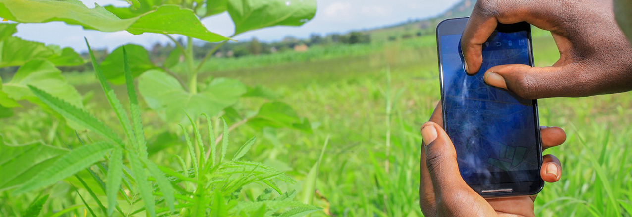
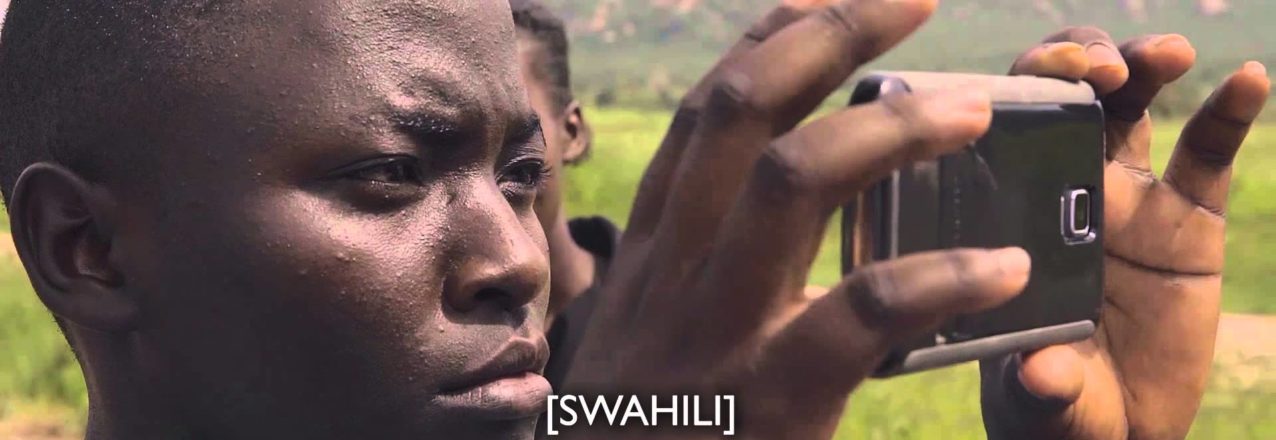
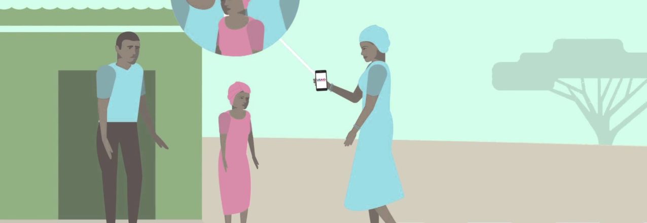
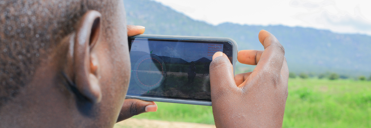
    In 2015, USAID’s Mobile Applications to Secure Tenure (MAST) program began with a simple idea: could you use low-cost smartphone-based mapping tools and community participatory methods to register land rights? The initial pilot, launched in three Tanzanian villages, was a major success. Since then, different versions of MAST have been deployed in Burkina Faso, Burma, and Zambia. In 2017, look for USAID to continue to refine and expand the MAST program, bringing low-cost land mapping and registration tools to more and more communities around the world.

Mobile Mapping Expands Across Africa

This post originally appeared on Medium.

Around the world, millions of people lack documented land rights. In many countries, land surveyors are rare and demand exorbitant prices for their services, mapping and land registry systems don’t work properly, and land titles— something we in the United States take for granted — can take years to issue and cost hundreds if not thousands of dollars to obtain.

But what if you could map land cheaply, efficiently, and accurately, just using an Android app?

Read the full post on Medium.

USAID’S Mobile Application to Secure Tenure (MAST)

In Tanzania, USAID trains youth to map and record rural land rights with an easy-to-use smartphone app—MAST.

The process allows local people to receive government-issued Certificates of Customary Rights of Occupancy (CCROs) for their land. The CCROs, paired with USAID-delivered training on land laws and women’s land rights, are increasing tenure security, empowering women, and reducing conflict.

Download the video transcript.

More information and stories on USAID’s mobile technology can be found at: usaidlandtenure.net/land-and-technology.

Technology and Land Rights: You Asked, We Answered

At the February 11, Digital Landscapes: Technology and Land Rights event we received numerous interesting questions about how rapid technological innovations in the land sector can help improve the lives of women and men across the globe. Today, we would like to share the three questions we found most interesting and provide some additional resources where you can learn more about the technologies USAID is piloting in the land sector.

Question: This [mobile] technology is great. But how does it engage with the statutory – customary divide in land rights? How would it engage with returning refugees who have no documents?

Answer: This is an important insight and one to which USAID is attentive. For example, USAID has developed Mobile Applications to Secure Tenure (MAST), a suite of flexible tools for securing customary land rights in different contexts. One of these mobile applications is currently being used to map and record customary land rights in Zambia’s Eastern Province. Approximately 90 percent of the land in Zambia is held under customary systems and there are few highly accurate and accessible maps available. With pressure to access and use land and land-based resources increasing—driving conflict over land—finding ways to secure customary rights is an important challenge. To learn more about USAID’s MAST/Zambia efforts, see this blog and this photo essay.

Question: How can women participate more actively in connecting technology and land rights, especially in the Global South?

Answer: Recognizing that it is often difficult for women to access, use and benefit from technology, USAID places a special emphasis on engaging with women—as both technology users and project beneficiaries. For example, the USAID MAST/Tanzania pilot maps and records land rights in Iringa Rural District. This project works with local youth, called Trusted Intermediaries, and trains them to capture geospatial and land rights information using GPS-enabled smartphones. USAID has worked closely will villagers to train and support female Trusted Intermediaries, and to ensure that village-level governance and land adjudication bodies have sufficient female representation. USAID has also provided specialized training on women’s land rights under the law to ensure that as rights are recorded and mapped, women have a clear, respected voice in the process. To learn more about USAID’s MAST/Tanzania efforts, see this commentary.

Question: Community-based land administration, which requires computers, can be difficult to sustain without adequate funds, electricity, secure locations, technical support. What are your tips for improving sustainability?

Answer: As noted by panelist Frank Pichel of Cadasta Foundation, new developments such as cloud-based computing and data management may be one interesting option to better ensure sustainability of community-oriented land administration. As costs to digitally host land information decease, more communities should be able to record and store a variety of information about land, boundaries, natural resources, migration routes, etc. on accessible platforms. One interesting example of a cloud-based platform that is helping promote sustainable outcomes for land management—LandPKS—was highlighted by USAID’s Senior Geospatial Analyst, Ioana Bouvier. Learn more about LandPKS (a joint project supported by USAID and USDA) here.

Learn more about technology and land rights by watching a complete recording of the Digital Landscapes panel discussion.

The Digital Landscape: Technology and Land Rights

Innovative tools and emerging technologies in the land sector offer new potential to improve the lives of women and men around the world. Rapid developments in technology are making it possible to solve development challenges in ways that seemed impossible just a few short years ago. Tools—such as smartphone apps that help people map and certify land; an open-source database that connects farmers, pastoralists and scientists across the globe; and participatory mapping programs that help clarify and secure tenure in customary settings—are making it easier for governments and local communities to efficiently manage land and resources and for individuals to understand and exercise their property rights.

Learn some of the keys for success in ensuring that technology solutions are context-appropriate, flexible, effective and sustainable. And find out from our expert panel what exciting possibilities lay ahead for technology in the land sector.

Moderator
Bhanu Rekha
Geospatial Media
Panelists
Ioana Bouvier
USAID
Frank Pichel
Cadasta Foundation
Lisa Kay Lewis
Thomson Reuters


Photo Essay: The Faces of Ilalasimba

In 2014, USAID launched the Mobile Application to Secure Tenure (MAST) pilot project in Ilalasimba, a village in Iringa Rural District in Tanzania. MAST is testing an innovative approach to document land rights that uses a new mobile application to map and record the geospatial and demographic data that the Government of Tanzania needs to issue Certificates of Customary Rights of Occupancy (CCROs) – formal land rights documents.

Before mapping begins, villagers learn about Tanzania’s land laws, with a special emphasis on women’s statutory land rights. They are taught dispute resolution techniques to help manage conflicts that might arise during mapping. And a small group of villagers were trained to use the MAST application on smart phones. Training was completed in April, 2015. Eight “Trusted Intermediaries” worked alongside members of the Ilalasimba Land Adjudication Committee to map over 900 parcels.

By leveraging open-source technology and a participatory, transparent process to deliver CCROs to villagers, MAST hopes to increase tenure security for women and men while allowing the Government to meet commitments to formalize more land rights in the country. Here is some of what some community members had to say about the project:

It Takes a Village – Mapping Land Rights in Tanzania

Later this month, several hundred villagers of Ilalasimba, Tanzania will receive formal documentation of their land rights thanks to a USAID pilot project called Mobile Application to Secure Tenure (MAST). Launched in 2014, the pilot tests an innovative approach to mapping and registering land rights. Through an easy to use, open-source mobile application, the project empowers villagers with the training and tools to identify parcel boundaries and gather the demographic and tenure information that government officials need to issue formal land rights documents called Certificates of Customary Rights of Occupancy. This makes the process of securing land rights more timely, accessible and transparent for local people and communities.

“BEFORE THIS, MANY PEOPLE DID NOT UNDERSTAND THE IMPORTANCE OF LAND AND THEIR RIGHTS ON LAND.”

USAID has developed a participatory methodology to implement the pilot, combining the use of technology with village-wide trainings on Tanzania’s land laws to build knowledge and strengthen capacity to support dispute resolution.

The approach works this way: first, village and hamlet-level workshops provide training on the legal framework of Tanzania’s land laws to members of the Village Assembly, Village Council, Land Adjudication Committee and others, with a special emphasis on women’s rights to own and inherit land. Next, USAID works with villagers to select and train a small group of young villagers to use the mobile application on Android-based smartphones.

These young people, called Trusted Intermediaries, then work alongside members of the village Land Adjudication Committee to map the boundaries of villagers’ land and enter demographic and other information about parcel holders. The intermediaries make certain that parcel holders (or their representatives) and the neighbors of parcel holders are present when mapping occurs.

Oftentimes, conflicts arise when rights to land and property are being demarcated and recorded. In order comply with Tanzania’s law and to reduce this risk, the four women and four men on the Land Adjudication Committee play a critical role resolving disputes that arise between family members or owners of neighboring parcels and validating the claims of parcels holders.

The information collected by intermediaries is then uploaded to a cloud-based database where government officials can access and validate it. Once validated by the District Land Office, the government is able to issue formal recognition of land rights, certificates, to villagers. This community-driven process is helping build local capacity and addresses one of the major bottlenecks in the traditional process of formalizing land rights: a dearth of surveyors.

The results from first phase of the pilot project are encouraging: In just under three weeks, the intermediaries mapped and collected information for 937 parcels. Some even went a step further and learned how to validate the data that they collected in the field. Jackline Nyantalima, a 23-year old woman said of her experience as a Trusted Intermediary: “This work provided priority to women. I was trained on land rights. Before this, many people did not understand the importance of land and their rights on land. This work has importance for our society.” Her colleague, Desmond Chumbula, a 30-year old man said: “I can tell the importance of this [work]. Before we were using paces to measure land, now we have a simplified process and you really know the size of your farm.”

With greater clarity about ownership and parcel size villagers should have enhanced security and increased incentives to invest in their property. This change may be particularly important for women: as Village Council member Ms. Sandina Kasike said in May:
“Before this project, widows were dispossessed. Now I see I have rights too. This means the future generation will be better off. Even if I pass away, my grandchildren and great grandchildren will have rights to own this land.”

Now the women of Ilalasimba have greater security and protection for their assets; USAID registered 30% of parcels in the names of women alone; 40% were registered jointly to men and women and another 30% were registered to men alone.

In July, when the certificates are delivered to the women and men of Ilalasimba, the project will meet a major milestone: providing local people with formal recognition of their rights. However, the project will not end there. USAID is expanding to two other villages in Tanzania and, as a result, will help improve land tenure security and enhance capacity for several hundred more people – the beginning of a big change in Tanzania’s villages.

Webinar: LandPKS Mobile Applications Launch

On April 14, 2015 the Land Potential Knowledge System (LandPKS) program, which aims to increase access to global and local land potential knowledge, hosted a brownbag/webinar marking the global release of its first two mobile applications: Land Info and Land Cover.

Speakers: Jeffrey Herrick, LandPKS Lead, and Ioana Bouvier, Senior Geospatial Analyst, USAID’s Land Tenure and Resources Management Office

Mobile Solutions Matter for Land

USAID designs, tests, and evaluates innovative and cost-effective land and resource governance and property rights approaches around the globe that can be adapted and scaled. This video, “Mobile Solutions Matter for Land,” presents two such innovations: the Mobile Applications for Secure Tenure (MAST), and the Land Potential Knowledge System (LandPKS).