Landing Home

By Land and Rural Development Program in Colombia

A municipal land office in Ovejas is giving local government a role to play in land administration.

For 72-year-old Glenys Mariela Salazar, retirement has not made life easy. A victim of Colombia’s armed conflict, her main occupation for the last 20 years has been survival. In 2001, paramilitary gangs and a bloody massacre drove her and her family from their home in Salitral, a small village in the Montes de María region of northern Colombia. She left with 10 children between the ages 3 and 16. She and her husband abandoned their business, a billiard table in the village’s main plaza, forever.

Like thousands others from the region, they ended up in the town of Ovejas, Sucre, occupying rickety huts built on the edge of the village. For several years, she and her husband went back and forth to their property in Salitral, just 30 kilometers away, trying to maintain a connection to their land and salvage what they could. When the Colombian military chased them away in 2003, they stopped returning.

They filed a claim with the country’s Land Restitution Unit but heard nothing. In 2008, an international housing subsidy reached Ovejas. The municipality granted them land, and their neighborhood of two dozen displaced families began to construct sturdy homes on the edge of the town. They were connected to the electric grid in 2011. However, they lacked regular water and had no connections for natural gas.

The Path to Ownership

Large swaths of urban centers across Colombia are populated by victims like the Salazars, families displaced from their lands and forced to live in cities. So when in 2017, the mayor of Ovejas handed Gladys a land title for her little house in Ovejas, she and her family rejoiced. This type of government support was unprecedented. Typically, local leaders spend public funds on roads, city park improvements, aqueducts, or other publicly tangible infrastructure that will convince residents the government is spending money for their benefit. Such investments tend to generate votes during election season.


MAST: Supporting Community Forest Management in Liberia

By the USAID LTS Team

Liberia depends on its forests. The forestry sector contributes 10 percent of the country’s GDP. One in three rural Liberians (1.5 million people) live in forested areas and rely on forests for a significant source of their livelihoods. And Liberia’s forests are a global biodiversity hotspot, comprising more than half of West Africa’s remaining Upper Guinean tropical forest. Yet Liberia’s forests remain under serious threat.

Notwithstanding its importance to the country, sustainable forest management – at both national and community levels – remains a considerable challenge, in part due to lack of reliable information regarding forest condition and resources rights.[1] Moreover, communities have limited information about their customary resources, despite the recent passage of the Land Rights Act of 2017 (LRA), which provides the legal framework for forest communities to document land boundaries outside of the forest conservation areas. In response to this dilemma, USAID is testing its Mobile Applications to Secure Tenure (MAST) initiative in Liberia to help communities define, map, record, and document their resources to enhance biodiversity conservation while improving community forest management. MAST provides a participatory framework and flexible tools that empower citizens in the process of documenting and managing their forest resources. The end result is clearer, stronger rights and greater incentives to invest and conserve resources.

The MAST Liberia pilot works closely with USAID/Liberia’s Forest Incomes for Environmental Sustainability (FIFES) program and villages in Blei Community Forest in Liberia’s Nimba County to test participatory methods that enable communities to collect, validate and manage information regarding community forest and customary resources. While communities surrounding Blei Forest highly value forest protection, they are faced with the need to balance conservation with the development of alternative, resource-based sources of income. The pilot aims to enhance the community’s ability to clarify the use of forest and customary resources, to monitor their condition, and to make informed decisions. MAST can help consolidate land and forest resource information and provide an important platform to engage stakeholders in making critical decisions regarding their use.

Want to learn more about MAST? Visit the MAST Learning Platform at:

[1] Id.

A President’s Promise

By Land and Rural Development Program in Colombia

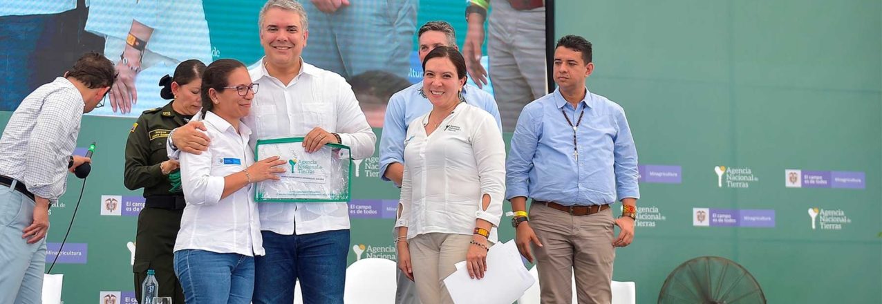
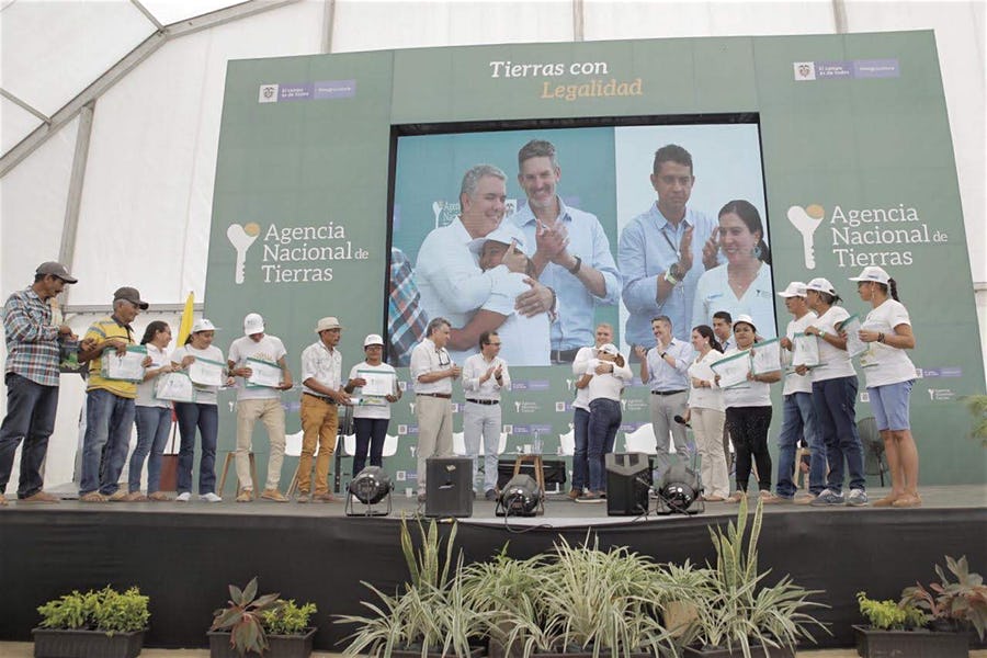
President Iván Duque signs statement of commitment to deliver land titles following the USAID-supported Massive Land Formalization Pilot.

The Final Step

The President of Colombia, Iván Duque, and Mark Green, Administrator of the United States Agency for International Development (USAID), met and signed a joint statement of support for the Massive Land Formalization Pilot, which is nearing completion in the municipality of Ovejas, Sucre.

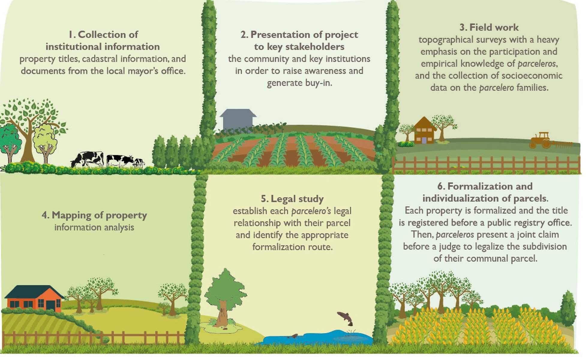
The Ovejas Land Formalization and Multipurpose Cadaster Pilot is an unprecedented undertaking in Colombia that reduces the overall costs of land administration by streamlining the collection and processing of land tenure and cadastral information while also providing government land agencies with comprehensive and reliable land data.

“When this government took over, less than 20% of the country had an updated cadaster. With USAID’s support and new public policy, the goal is to update the cadaster for 60% of the country by 2022, and try to reach 100% by 2024. The Ovejas Pilot in Ovejas is proof that land titling, property, financial inclusion and agriculture strengthening programs can be a reality.”

-Iván Duque, President of Colombia

Property Rights

In the signed joint statement, the Government of Colombia commits its support to bring the USAID-supported activity to completion, setting the stage for the government to continuing building on the simplification and expansion of land titling and cadaster to improve land administration in Colombia.

The Ovejas Pilot is facilitating property rights to around 2,900 campesinos, more than half of whom are rural women while simultaneously updating the cadaster information for 5,600 land parcels.

In Ovejas, six out of every 10 parcels lack property titles, creating serious impediments to a thriving environment for sustainable and inclusive rural development. The Ovejas Pilot addresses 100% of the municipality’s land informality, uses conflict resolution mechanisms, and places emphasis on women’s property rights.

“Formalizing land rights will mitigate a key driver of conflict in the countryside, and create new economic opportunity and improve quality of life for the rural population. This is an historic achievement, and I am proud of USAID’s involvement to help pilot the program; one that can be scaled throughout Colombia. It is an example of what we can accomplish together.”

-Mark Green, Administrator of USAID


What’s in a Title?

By Land and Rural Development Program in Colombia

Discussions about land tenure in development aid often end up like this: a question mark whether land titles are enough to alleviate poverty. Property titles—people tend to argue—provide landowners with an asset, which can be used as collateral to access credit and create capital to improve productivity and adopt new technologies. But are they enough to lift families out of poverty?

Experts say land titles strengthen the bond between farmers and land and create incentives to invest more in their patrimony, including their children’s future. Study after study demonstrates improvement in the factors that contribute to poverty, from reduced child labor to higher spending on education and food.

These studies are hard to dismiss, but the road to prosperity has many detours, especially for women.

In rural agriculture, ensuring land tenure for women is of particular relevance, especially where women are the main breadwinners or where antiquated land policies undermine women’s rights. The truth is that without investments in infrastructure, robust policies, and economic opportunities, a land title is little more than a small step up a big mountain.

Colombia is no stranger to the issues of land informality. A five-decade conflict often revolved around access to and the acquisition of land, and six of every 10 land parcels is informally owned. Indeed, the inequity and poverty born from the conflict led to land reform schemes that sought to go beyond “just a land title.”

For example, during several years, Colombia’s former land authority, INCODER, doled out more than 1,000 land tracts— each one known as parcelaciónto some 28,000 families. Each parcelación groups 20-plus families together and requires them to work together through a farmers’ association. The catch: they must manage their land under one land title. As one might expect, the attempt to ensure land tenure and create economic success fell short on both fronts. 


Transforming Land Rights Management in Tanzania

In Tanzania, smallholder land registrations are critical to protecting local land rights. However, since passing the Village Act in 1999 to provide for the management of village lands, the process of registration has moved slowly due to limited operational capacity. To bring the law into full effect, procedures for registration and administration need to be low-cost, simple, and equitable. In addition, the land registration system must support future transactions and allow registers to be maintained at village and district levels.

Under the Land Tenure Assistance (LTA) activity, funded by the U.S. Agency for International Development (USAID), DAI is modifying an existing tool for mapping smallholdings and detailing ownership claims—the Mobile Application to Secure Tenure (MAST)—which USAID first piloted in Tanzania. This tool will be linked to a low-cost land registry tool, the Technical Register Under Social Tenure (TRUST), which DAI is developing at the district level and plans to scale up to other areas of the country. The outcome is a low-cost, participatory land registration process that is transforming the way land rights are managed in Tanzania, with the potential for adaptation elsewhere.

Read the full story


Titling Priorities

By Land and Rural Development Program in Colombia

Maritza Losada moved to Puerto Guadalupe, Meta five years ago when her husband found a job with a large biomass energy company that grows sugar cane. She and her husband purchased a lot in the town’s poorest neighborhood, Barrio Nuevo. The district remains today much like it was in 1995 when the government created the housing project for future agro-laborers: no roads, no sewage, no gutters.

The town sits on banks of the Meta River, which flows into the Orinoco River, and allows farmers and agro-industrialists to transport their goods over hundreds of miles across the eastern plains of Colombia. Nevertheless, this river and the rainy season turn Maritza’s neighborhood into a muddy bog. Every year, the neighbors lay down stones and boards to build walkways to maneuver about their homes.

Over time, they have erected makeshift electric posts and wires to gain access to light and electricity. Maritza’s house too has slowly evolved, from a canvassed shack to a more durable, yet uninsulated, structure with a zinc roof and walls. Inside, there are no dividing walls or rooms; in one corner sleeps her two children, in the other she and her husband. She is currently expecting her fourth child.

With a reliable income and work benefits, under the law, her husband could access money deposited in his retirement pension for certain objectives, including for home improvements. There is only one problem the couple never processed the paperwork for a registered land title for their property. With no registered property title, Maritza and her family cannot access this nor any other government subsidy.


Romancing the Cacao

By Land and Rural Development Program in Colombia

When Colombia held Chocoshow, its first national cacao trade show, at the end of 2018, growers readied their finest cacaos to compete for recognition and fame on the nation’s stage. A victory for any lot of high-grade cacao would be a welcome boost to a sector constantly struggling with price fluctuations.

Meta-based cacao growers’ association Asopcari was prepared. After two years of fundamental changes in how its producers harvest and process cacao, the association came to Chocoshow with high hopes. In the end, it walked away with one gold and one silver medal, a triumphant showing for a group of 90-plus growers scattered about the Ariari river valley.

The growers have not always been great at production, Lopez admits, but it is not for lack of trying. The history of cacao in Meta is one of success and tragedy. By the mid-eighties, cacao was a cash crop for thousands of farmers, and annual production peaked at 5,000 tons. By 2000, illicit crops had essentially gutted Meta’s cacao future, destroying more than 7.5 million trees and leaving families in a far more vulnerable state.

In 2000, Asopcari was created and started with 300 hectares of quality cacao clones. In 2004, Meta cacaoteros produced a meager 400 tons of cacao. For Asopcari and others, it was going to be an uphill battle. Since then, the efforts to recuperate cacao cultivation in Meta have been slow. For more than a decade, much of Meta was off limits due to conflict, the drug trade, and an overwhelming distrust of anyone and everyone, making it especially difficult to establish sustainable marketing channels.

To make matters worse, the government delivered little necessary technical assistance to improve growing and harvesting techniques. Farmers soon lost track of which trees were improved varieties and bundled all cacao together, regardless of origin or type.


“Everyone is treated equally because those who plant a half hectare today may be planting 300 tomorrow.”

Q&A with Alejandro Zuluaga, executive manager of Almidones de Sucre

By Land and Rural Development Program in Colombia

In 2008, the government created the company Almidones de Sucre in order to stimulate rural development in the Montes de María region and to provide added value to the cassava value chain. For several years, the company worked to build a business culture with cassava growers and increase production. In 2017, with the arrival of USAID support, Almidones benefited from the consolidation of a public-private partnership, which generated the synergy needed in the sector. The commercial manager of Almidones de Sucre, Alejandro Zuluaga, talks about this partnership and the evolution of the industrial cassava sector in Colombia.


USAID’s MAST Mobile Tech Programs Promote Women’s Empowerment in Tanzania and Zambia

By Deborah Espinosa and Patrick Gallagher, USAID’s Land Technology Solutions Program

Persistent and pervasive gender inequality is a global development challenge that constrains economic growth, educational opportunities, and health outcomes. It jeopardizes food security and undermines poverty reduction strategies. The world over, some formal and many informal laws and customs operate to hinder women’s empowerment and thus their full potential as agents of economic and social change.

A woman holding her land certificate in rural Zambia. Photo: Jeremy Green/USAID.

Arguably, in no sector are gender disparities so prevalent and disempowering to women as in the land and property rights sector. For women, documented land rights can confer direct economic benefits and lead to greater autonomy, increased bargaining power within their communities and households, and enhanced resilience. Worldwide evidence suggests that when women enjoy secure rights to land, their control over household income increases.[1]

In much of the world, however, the ownership and control of land is a source of power, prestige, and profit. Not surprisingly then, women’s ownership and control over land is almost always constrained by entrenched traditions and practices that limit women’s participation in public life, even if formal laws recognizing women’s land rights are in place.

Importantly, USAID’s new and innovative tool for documenting land rights has proved impactful in reversing these trends. USAID’s Mobile Application to Secure Tenure (MAST) has worked to reduce gender equality and promote women’s empowerment in communities where it has been implemented. MAST is a suite of easy-to-use tools and methods that help communities efficiently, transparently and affordably map and document their land and resource rights. MAST combines a mobile application with a robust data management platform to capture and manage land information, including names and photographs of people using and occupying land, details about land used, and information regarding an occupant’s claim to the land.

Working with local governments, customary leaders, and civil society organizations, USAID is leveraging MAST to recognize and record both women and men’s rights to rural land, with positive women’s empowerment outcomes in Tanzania and Zambia.

In Tanzania, for example, although Tanzanian women comprise 50 percent of the population and provide 80 percent of total agricultural labor (a sector which employs 77 percent of Tanzanians), country data indicates that only 27 percent of women are landowners.[2] The country ranks 119th (out of 189) on the UNDP’s 2013 Gender Inequality Index. In 2018, Tanzania’s ranking has even fallen since its 2013 ranking of 130th. [3] [4]A key reason cited for Tanzania’s drop in the rankings is the persistence of gender inequalities in access to and control over land and other financial resources, and the additional burden that poverty places on Tanzanian women.[5] Another gender disparity in Tanzania is the low proportion of women in decision-making positions at regional and local government levels.[6]

Figure 1. Gender of MAST beneficiaries by location. In Iringa, Tanzania and Zambia, approximately 45% of MAST beneficiaries are female.

And yet, four years into USAID’s MAST-based Land Tenure Assistance (LTA) Program, almost 45 percent of project beneficiaries receiving land certificates are women (see Figure 1). Similarly, under USAID’s Tenure and Global Climate Change program in Zambia, two civil society organizations, Chipata District Land Alliance (CPLA) and Petauke District Land Alliance (PDLA), used MAST to also register about 45 percent of customary land in the names of women in a country with similar traditional constraints on women.

In both of these countries, MAST’s approach has been critical in promoting gender equality and women’s empowerment in the land sector. MAST includes on-the-ground trainings, using inclusive and participatory approaches to build capacity of communities to document, manage information about, and understand their land and resource rights. The MAST approach operates transparently, encourages full participation of community members, and increases the understanding of land rights of all beneficiaries, particularly women’s rights.

To hear directly from Zambian women on their experiences obtaining land certificates, see the USAID video, In My Own Name, Empowering Women Through Secure Land Rights.

What Does the Data Say?

Figure 2. Gender of MAST-assisted landowners by their occupancy type and location. Percentages are calculated within each site, and Tanzania data is representative of Iringa region only. Though men dominate the single occupant/landholder types, women are equally represented in the co-occupancy/joint types.

A gender analysis of data on individual versus collective landholdings provides further insight useful for future programming. In both Tanzania, and Zambia, more men hold land individually, while more women hold land jointly or in co-tenancy arrangements. This finding is backed by research indicating that female ownership of land is generally held together with husbands, whereas men are more likely to be sole owners of land.[7]

Despite that, men currently represent a higher proportion of individual landowners, the implementation of MAST has proven effective in promoting gender equality and empowering women by providing a technology coupled with an inclusive approach for recognizing and documenting land rights. In Zambia, land documentation had positive impact on household perceptions of improved tenure security,[8] and in Tanzania, there was an11% increase in respondents who felt that disputes over land will improve in the next year.[9]

Under USAID’s Tenure and Global Climate Change program, about 45% of all customary land certificates have been issued to women using Mobile Applications for Secure Tenure (MAST). Photo: USAID.


To learn more about MAST, visit USAID’s MAST Learning Platform at:
www.Land-Links.org/MAST or contact Ioana Bouvier (ibouvier@usaid.gov).

[1] Meinzin-Dick, et al. 2017. “Women’s Land Rights As A Pathway to Poverty Reduction: Framework and Review of Available Evidence, in Agricultural Systems, https://www.sciencedirect.com/science/article/pii/S0308521X1730505X.
[2] FAO. 2014. Gender Inequalities in Rural Employment in Tanzania Mainland An Overview.
[3] UNDP. 2018. Human Development Report.
[4] UNDP. 2018. Human Development Report.
[5] UNDP. 2018. Tanzanian Human Development Report 2017: Social Policy in the Context of Economic Transformation. Tanzanian women spend 13.6 percent of their time per day on unpaid care work compared to 3.6 percent for their male counterparts. Id. As a consequence, women’s availability for income-generating activities is reduced, to the detriment of themselves and the household and local economies.
[6] Id.
[7] Land Alliance and ODI. (2017). “Prindex Analytical Report.”
[8] USAID. 2018. USAID Tenure and Global Climate Change Evaluation Report.
[9] USAID. 2017. Baseline Report: Impact Evaluation of the Feed the Future Tanzania Land Tenure Assistance Activity.  

Quick and Efficient: USAID’s MAST Mobile Tools Speed Up Time-Consuming Land Mapping Processes

By Deborah Espinosa and Patrick Gallagher, USAID’s Land Technology Solutions Program

There is much debate about the extent to which our prolific use of mobile technology affects our lives. While the broader debate rages on, the results on how smartphones can lead to improved development outcomes is becoming clearer. For example, a recent study in Ghana found that smallholder farmers’ mobile phone ownership and use significantly improves agricultural productivity when also combined with provision of extension services, and enhanced market participation.[1]

Land tenure and property rights is another emerging area where mobile technology can enhance development in powerful ways.  USAID’s Mobile Applications for Secure Tenure (MAST) initiative is empowering rural communities to define, map, record, and document their land and resources. MAST combines participatory approaches and mobile technology platforms with on-the-ground training to engage communities to map and document land and resource rights through efficient, transparent, and accurate processes. Significantly, these communities are applying this technology more efficiently than more traditional methods and at scale.

The MAST approach is comprised of easy-to-use mobile phone and tablet applications, combined with a robust data management platform, which captures and manages land information that can include names and photos of the people using and occupying land, details about what the land is used for, and information regarding occupants’ claims to land. In addition, on-the ground training of community members builds their capacity to document and manage information about land and resource rights, while participatory approaches ensure that communities understand those rights.

In Burkina Faso, the MAST approach proved to be roughly nine times faster than traditional methods. With MAST tools in hand, and in partnership with the community members, the country’s Rural Land Service required only four months to complete the process of mapping 2,638 parcels in four villages, with verifications averaging 30 minutes each. In comparison, using traditional methods, the same authorities mapped only 3,706 parcels over a four-year period.[2]

By working in tandem with community members—especially youth—MAST enables citizens to map and document their own land and resources in less time, while promoting community autonomy in land tenure processes. For instance, MAST has been implemented on a variety of time scales; the technology can be deployed to map an area intensely for a short time, or more gradually over longer periods of time. Paired with community ownership, this means that the technology is flexible enough to meet the needs of the community.

Chieftainess Mkanda distributes land certificates documented through MAST in Zambia’s Eastern Province. Photo: USAID Tenure and Global Climate Change Program.

Efficiencies in mapping are also evident through entire certification processes in Burkina Faso, Tanzania, and Zambia, demonstrating that MAST is a scalable tool. As MAST implementations scale up, the duration between demarcation and certification shortens. MAST allows the certification process to become more efficient as time passes. In contrast, traditional processes generally do not become more efficient over time because of their reliance on older technologies, significant labor, and time-intensive manual processes.

Thus, despite MAST having higher upfront costs related to adapting or customizing the technology suite to specific land tenure context, its significant efficiency gains over time have allowed implementers to leverage mobile tools and citizen-centric approaches for replication and scaling regardless of the context. Ultimately, the MAST approach is not only a rapid and scalable tool, it also becomes more efficient over time as users become familiar with the technology. And this means that land documents get in the hands of the landholders even sooner.

To learn more about MAST, visit USAID’s MAST Learning Platform at:
www.Land-Links.org/MAST or contact Ioana Bouvier (ibouvier@usaid.gov)

[1] Haruna Issahaku, Benjamin Musah Abu & Paul Kwame Nkegbe (2018) “Does the Use of Mobile Phones by Smallholder Maize Farmers Affect Productivity in Ghana?”, Journal of African Business, 19:3, 302-322.
[2] A Mobile Application to Secure Land Tenure, Michael Graglia and Christopher Mellon, Aug. 3, 2017 (https://www.newamerica.org/future-property-rights/blog/mobile-application-secure-land-tenure/);
Issifou Ganou, Medard Some, Raymond Soumbougma, and Anne Girardin, Using Mobile Phones, GPS, and the Cloud to Deliver Faster, Cheaper, and More Transparent Land Titles: The Case of Burkina Faso. Paper prepared for presentation at the “2017 WORLD BANK CONFERENCE ON LAND AND POVERTY,” The World Bank – Washington DC, March 20-24, 2017.