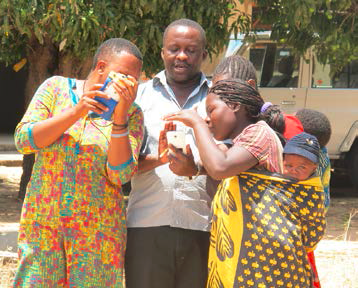
In October 2015 the Mobile Application to Secure Tenure (MAST) pilot project launched Phase 2, which is focused on scaling the use of the innovative mobile technology tools to collect land rights information in rural Tanzania.
MAST was the first field tested in Ilalasimba, a rural village of 345 families. In late April and early May, local youth in Ilalasimba were trained to use MAST’s two applications to record parcel boundaries and land rights information for their neighbors. These eight young “Trusted Intermediaries” collected over 900 parcel boundaries in just under three weeks, along with information about the parcel owners, their family members and the kinds of claims they hold over land. This information, which is stored on a cloud-based database, was validated by District Land officials in Iringa and then used to issue formal documentation of tenure rights called Certificates of Customary Rights of Occupancy (CCROs). In a ceremony, in July 2015 910 CCROs were delivered to these families.
In October, after additional adjustments to the applications were complete, MAST began its process of community engagement, working with the Village Council and Village Assembly as well as District Land Officials, Ministry of Lands officials, and local partners CARE Tanzania and TAGRODE in Itagutwa.Villagers in Itagutwa were trained on the components of the 1999 Village Land Act and they received special training on women’s land rights under the law and dispute resolution.
Finally, new Trusted Intermediaries were selected – these young women and men worked with four of the Trusted Intermediaries from Ilalasimba for several days to learn how to use the mobile applications, how to conduct a field mapping exercise and why this effort is helpful for villagers. Itagutwa’s young mappers were able to collect over 1,000 parcel boundaries and information about parcel owners in late October and early November and the project is now working to validate this data in advance of another CCRO delivery ceremony in early 2016.
Working with these talented youth has helped USAID test the concept of participatory data collection for land information. Partnering with young villagers, and with village leaders, in an open and participatory process reduces the time and costs associated formalizing land right and it empowers local people by putting part of the land administration service delivery process literally in their hands.

