TGCC Success Story: Learning from Participatory Mapping and Legal Training to Secure Land Tenure

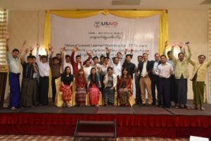
Local partner participants celebrate their accomplishments at Land Tenure Project’s closing workshop in Nay Pyi Taw.

As activities for USAID’s Land Tenure Project (LTP) drew to a close, the project hosted a series of regional workshops to bring stakeholders together to reflect on their experiences in participatory mapping pilot activities and land legal awareness training. Meeting in Kalay, Sagaing Region; Pathein, Ayeyarwady Region; and, Taungyi, Shan State, LTP invited community members, government authorities, and locally led civil society organizations to share lessons learned from the year-long pilot activities. Participants reported on the linkages between mapping activities and their increased understanding of land tenure issues. They identified benefits associated with community-led land resource documentation, and the dialogue that was opened between government and community stakeholders surrounding land concerns.

Reflecting on the value of community-led land use mapping and land legal awareness training, a General Administration Department official from Pathein Township, Ayeyarwady Division noted, “We welcome [mapping and legal training] and want communities to understand the registration process and laws. We are now familiar with the mapping technique. Communities often don’t understand and will now be able to better discuss.”

Historically, mapping activities in Burma have been government-led and have employed opaque, top-down approaches, which do not take into account community perspectives or realities on the ground. As stakeholder meetings have reported, lessons learned from LTP pilot programs demonstrate potential for a shift from past land documentation processes. In place of outdated processes, communities are ready to advocate for participatory, bottom-up approaches that help local authorities become well-informed, true service providers in land and resource management.

TGCC Success Story: Zambia’s Chiefs Participate in National Land Audit

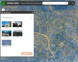
Zambia’s National Spatial Data Infrastructure (NSDI) was launched in December 2017, combining the Ministry of Lands’ titled parcels with customary land parcels that were mapped and validated through USAID support.

Though over half of Zambia’s population of seventeen million citizens relies on agricultural land for their livelihood, Zambia’s national land information system houses less than 200,000 records of landholdings. Historically, the Ministry of Lands has had no records of individual landholdings from the over 70 percent of the country that is managed by Zambia’s 288 customary chiefs. This divide between state land administration and a largely undocumented customary land administration system has been blamed for many of the land disputes that have proliferated across the country over the past twenty years.

Recognizing the need for a modern and publicly accessible map of land allocations, in 2014 Zambia embarked on a National Land Audit and the creation of a repository for land data through a National Spatial Data Infrastructure. However, with respect to agricultural landholdings, the Audit and NSDI were limited to titled state land within the Ministry of Lands, leaving much of the country undocumented.

Enter the USAID Tenure and Global Climate Change Program and its partners in the Chipata and Petauke District Land Alliances. Five chiefs in these two districts requested assistance to undertake bottom-up processes for mapping chiefdom boundaries and household land allocations. From 2014 to 2017, over 500 villages across Chipata and Petauke Districts mapped over 15,000 parcels of household lands and identified owners and persons of interest associated with each parcel. Through collaboration with chiefs and sharing of data processes and technologies with the Ministry of Lands, trust was built with respect to the quality of community-driven customary maps. With the launch of the NSDI in December 2017, the government of Zambia placed customary parcels on the same map with its national cadaster, representing the first time this data has been available on a publicly accessible platform.

As more chiefs request assistance in undertaking audits of their customary land, the utility of the NSDI to both protect people’s rights and identify opportunities for productive investments will be realized.

TGCC Success Story: Pyoe Khin Thit Foundation Utilize Participatory Mapping to Address Village Land Rights

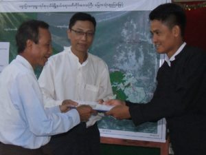
U Myo Thant of Pyoe Khin Thit Foundation delivers a village folio to community members from Shaw Pyar Village Tract, Pathein Township, Ayeyarwaddy Division

Pyoe Khin Thit Foundation (PKTF), a USAID Land Tenure Project partner, worked in eleven villages of Shaw Pyar Village Tract, Pathein Township, Ayeyarwaddy Division, to increase community members’ awareness of land laws and map village boundaries and land resources, creating an evidence base of community land use. The village tract has large areas of land with rubber plantations that were allocated with limited consultation. Community members now find their livelihoods constrained.

After six months of participatory engagement, in October 2017, PKTF organized a folio handover ceremony to share project results with members of the village tract, the Pathein District Member of Parliament, and government officials from the Forest Department and Ministry of Agriculture, Livestock and Irrigation. Folio handover is the final step in the participatory mapping process. At this event, communities and local government officials receive copies of village folios and maps that document the participatory process including all activities, community members who participated and findings related to land tenure concerns. Maps document the village’s land uses and boundaries.

Village leaders and the village tract administrator together identified how they want to use the community maps in conjunction with building a greater understanding of the law. “Before PKTF we didn’t know much about the status of [Vacant, Fallow, Virgin] VFV land and what could be done to secure our rights,” says Myit Tun of Hlay Lone Taung Village. “However, now we have plans to apply for Form 7s to protect our individual fields.” While acknowledging that the maps are not formally recognized, the village leaders still see the maps as important tools.

In addition to securing household lands, the community also identified the need to secure community land. The village tract administrator stressed, “Our available land is used up and we see VFV land that government tells us is off limits, but it is not being used and we don’t see any plans, we would like to apply for access.”

The process has sparked an interest in having local level spatial information, and the village tract administrator has requested additional support and spatial analysis to help solve longstanding challenges.

TGCC Success Story: Third Annual Participatory Mapping Symposium Demonstrates Growing Momentum in Burma

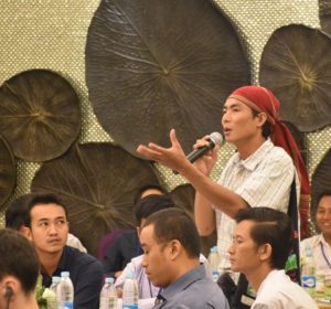
A participant reflects on participatory mapping approaches during two-day event.

In Burma, USAID’s Land Tenure Project (LTP) hosted its third annual Participatory Mapping Symposium in partnership with OneMap Myanmar and Land Core Group. The event convened 117 participants from across 46 organizations, including civil society organizations, non-governmental organizations, and government. Participants engaged in active discussion about the value of bottom up participatory mapping approaches to address land issues in Burma. LTP partners shared their experiences of using mapping to engage local authorities and communities to raise legal awareness around land and address community land-related concerns. The symposium identified next steps for strengthening a community of practice for participatory mapping and engaged participants in preliminary discussions about harmonizing mapping approaches in order to gain recognition and buy-in from the Government of Burma.

A member of the LTP team commented, “During first and second participatory mapping symposiums, CSOs could not involve [sic] much during the discussion of technical mapping activities and only technical people from NGOs/ INGOs gave presentations and led the discussions. Mostly, those CSOs are activists for policy advocates. But interestingly, this year, [at the] third mapping symposium, LTP CSO partners gave presentations in each thematic group and shared their experiences, good practices and lesson learned during their participatory mapping work. They seem quite confident and enthused to share their work and experiences to other CSOs.”

Participatory mapping is a community-driven approach used internationally to document and recognize legitimate land tenure claims. In Burma, participatory mapping efforts are at an early stage, but are proving to be an important tool for addressing community perspectives on land-related concerns and for strengthening engagement between communities and local authorities. There were 65% more participants at this year’s symposium compared with last year’s, signaling growing interest in participatory mapping in Burma.

TGCC Success Story: How Andrews Darling’s Land Rights Affect Your Valentine’s Day

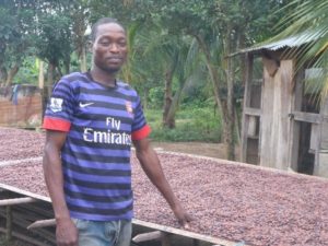
Andrews Darling with his cocoa bean crop

The world’s chocolate production is at a tipping point. Two-thirds of the world’s cocoa is sourced from trees of individual smallholders in just two countries in West Africa: Ghana and Cote d’Ivoire. While demand for chocolate is expected to increase by 25 percent in the next decade, a huge percentage of West Africa’s cocoa trees are well past their most productive years and yields are projected to decline. This leaves two options: either expand production into West Africa’s dwindling forests, or rehabilitate aging farms. The choice is clear.

Recognizing the risk to their survival, the world’s chocolate companies are increasingly supporting efforts by their suppliers, like Ecom Ghana, to rehabilitate farms by providing improved seedlings and extension service to cocoa farmers to rehabilitate farms and increase productivity. Yet even with this support, Ecom has found a surprising number of farmers reluctant to rehabilitate their unproductive farms.

Enter Andrews Darling, a cocoa farmer in Nyame Nyae village in the cocoa-growing region of Ghana, who migrated to the area from northern Ghana 14 years ago. Andrews says, “When I came to this area, I was 24, and I made an oral abunu agreement with the landowner where I would clear land and establish a cocoa farm with him. We agreed that we would split the farm 50:50 when the cocoa is mature. Now, my farm is getting older and I know that I will need to rehabilitate in the next ten years, but I know that if I replace trees, my landowner will object. The land could produce more with new trees, but I can’t risk being pushed off.” Migrants working on abunu oral contracts have limited security of their long-term rights to the land, and are thus unlikely to rehabilitate their farms.

Andrews’s village supplies all of its cocoa beans to one company – Hershey’s. Based on USAID surveys, over 60 percent of Nyame Nyae farmers are migrants with limited rights to rehabilitate the farms on which their livelihoods are based. With USAID help, Hershey’s and its local buying agent, Ecom, are supporting local farmers to document their abunu (landlord-tenant) agreements, and include provisions that allow tenants to rehabilitate their farms without risk of losing them.

Teriah Agyarko-Kwarteng, Hershey’s West Africa Sustainable Sourcing Director, noted, “In Ghana in recent years, insecure land rights has been raised in meetings in Accra as an issue facing productivity in the cocoa sector, but we have never had concrete actions that we could support as a business. With USAID’s help we are finding entry points that are practical cost-effective at the scale our business works in.” The templates developed under USAID support are expected to become a part of the standard extension services offered by Ecom to the smallholder farmers who supply Hershey’s, Mars, Ferraro, Nestlé, Lindt, and dozens of other small and large chocolate companies around the world. With more secure land rights, a new generation of cocoa farmers will be able to rehabilitate their farms and increase cocoa productivity while also improving their livelihoods.

TGCC Success Story: USAID Talks Tenure with University Students

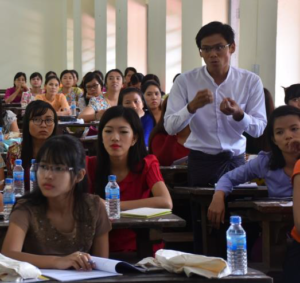
A student at Yangon University Law Department asks a question regarding land governance in Burma during USAID LTP’s guest lecture series.

USAID’s Land Tenure Project (LTP) hosted a guest lecture series with over 500 participants, including university students, to discuss land-related issues in Burma. LTP presented on topics such as land governance, policy and law, and political aspects of legal change. Lectures included discussions with students on international efforts by the donor community to strengthen the policy framework. Participants included undergraduate and graduate students, PhD candidates, and Law Department lecturers from the University of Yangon, Mandalay University, and Yezin Agricultural University.

A lecturer from the University of Mandalay Law Department noted, “We are now teaching land laws and administration to second-year students as compulsory subjects. Our lectures mainly focus on theory. Now, LTP land governance lecture series…is very supportive for our students to know the practical situation of land administration in country. This is a good initiative for us and we are now discussing with government representatives…who joined the lecture series as observers to hold knowledge sharing on land tenure workshop like this.”

Land-related issues will continue to be an important topic in Burma for years to come; new, well-informed leaders are needed to help address these issues. Bringing first-hand field experience and expert legal knowledge to students and teachers can help foster interest, raise awareness, and share lessons learned and solutions for land issues. Additionally, the lectures provide a dialogue between stakeholders and academics, and introduce USAID support for a strengthened land law framework to a broad, active audience. Notably, authorities from Government of Burma departments that have jurisdiction over land issues also joined the lectures and participated actively in dialogue.

TGCC Brief: Marine Tenure and Small-scale Fisheries – A Priority for Development Programming

Through its commitment to addressing extreme poverty, USAID is integrating a deeper understanding of the role marine tenure and small-scale fisheries play in supporting biodiversity conservation, food security, inclusive economic growth, and other priority development objectives. Maintaining healthy and resilient marine and coastal ecosystems provides the natural capital to support USAID’s objective to conserve biodiversity for sustainable, resilient development. Insecure resource tenure rights to fisheries can be one of the most significant drivers of biodiversity loss and unsustainable natural resource management. Where rights are poorly defined, marine and freshwater ecosystems can be quickly degraded, leading to overfishing. Securing resource tenure for fishers can set the stage for reducing pressures to biodiversity, creating sustainable livelihoods, enhancing food and nutrition security, building resilience, and reducing competition over limited resources.

Small-scale fishers play a significant role in the global fisheries sector. They represent about 90 percent of the world’s nearly 51 million capture fishers, of whom about half are women. They produce half of all global fish catch and supply two-thirds of the fish consumed by people. Small-scale fishers and coastal communities with secure rights over a given fishery, fishing ground, or territory have a strong interest in organizing and acting collectively to manage their resources sustainably. Securing tenure and strengthening governance of small-scale fisheries can have multiple development benefits. The following information brief provides an overview on the topic of marine tenure in securing sustainable small-scale fisheries and its role in meeting global development objectives. The USAID/E3 Office of Land and Urban’s Tenure and Global Climate Change Program has developed a sourcebook and guidance designed to assist USAID staff and partners integrate consideration of sustainable small-scale fisheries and the responsible governance of marine tenure in programming and project design.

KEY TAKE-AWAYS

WHY LOOK TO THE RESPONSIBLE GOVERNANCE OF MARINE TENURE TO SUPPORT USAID DEVELOPMENT OBJECTIVES?

Weak or inadequate governance of tenure within fishing communities and the marine and coastal environment has resulted in a substantial loss of food security, local income generation, biodiversity, and ecosystem services such as coastal protection. Coastal communities have long depended on the sea for food, shelter, livelihood, cultural practices, and other basic human requirements. These communities represent a highly vulnerable segment of society, who often lack secure land and marine tenure, are exposed to a range of coastal hazards, and are relatively invisible in terms of development priorities. The responsible governance of marine tenure supports the establishment of a set of rights and responsibilities for local communities as to who is allowed to use which resources, in what way, for how long, and under what conditions, as well as who is entitled to transfer rights to others and how. Formal recognition of marine tenure provides communities with the security that they can invest in and manage their fishery resources for long-term sustainability. A community’s secure right to make management decisions on resources within the coastal zone is crucial to building their resilience to the impacts of climate change.

HOW DOES MARINE TENURE SUPPORT SUSTAINABLE SMALL-SCALE FISHERIES?

Small-scale fishers and coastal communities with secure rights over a given fishery, fishing ground, or territory have a stronger interest in organizing and acting collectively to manage their resources sustainably. Marine tenure institutions and tenure rights form the overarching governance structure that enables a fishing group or community to establish rights to use resources from a defined territory as well as exclude outsiders. Secure tenure promotes stewardship of natural assets such as fish and creates incentives to maintain ecosystem goods and services. As such, the responsible governance of marine tenure forms a central component of this new small-scale fishery agenda, contributing to multiple development objectives including alleviating poverty, building resilience, strengthening food security, promoting gender equity, and conserving biodiversity.

WHY IDENTIFY LESSONS FOR DEVELOPING AND STRENGTHENING EFFECTIVE MARINE TENURE INSTITUTIONS AMONG SMALL-SCALE FISHING COMMUNITIES?

Working in a marine and coastal environment requires an adaptive approach based on up-to-date knowledge of dynamic ecological and social conditions. Local fisheries management institutions and approaches in the context of developing nations often include complex and diverse social, cultural, political, economic, and ecological arrangements and conditions. The consideration of these integrated factors is a key component of using a marine tenure approach when addressing and assessing marine and coastal-related issues. Ultimately, this understanding of the interconnected web of relations between people, institutions and resources implicit in marine tenure institutions can provide lessons on how they can be strengthened in the face of new challenges such as climate change and economic globalization towards the advancement of more resilient societies.

TGCC Brief: Taking Stock of the Voluntary Guidelines on Securing Sustainable Small-scale Fisheries – Development and Testing of a Country-level Assessment Tool

Through its commitment to addressing extreme poverty, USAID is integrating a deeper understanding of the role marine tenure and small-scale fisheries play in supporting biodiversity conservation, food security, inclusive economic growth, and other priority development objectives. Maintaining healthy and resilient marine and coastal ecosystems provides the natural capital to support USAID’s objective to conserve biodiversity for sustainable, resilient development. Insecure resource tenure rights to fisheries can be one of the most significant drivers of biodiversity loss and unsustainable natural resource management. Where rights are poorly defined, marine and freshwater ecosystems can be quickly degraded, leading to overfishing. Securing resource tenure for fishers can set the stage for reducing pressures to biodiversity, creating sustainable livelihoods, enhancing food and nutrition security, building resilience, and reducing competition over limited resources. The USAID/E3 Office of Land and Urban’s Tenure and Global Climate Change Program has developed a sourcebook and guidance designed to assist USAID staff and partners integrate consideration of sustainable small-scale fisheries and the responsible governance of marine tenure in programming and project design. As part of this guidance, USAID is developed and tested a country-level assessment tool to promote awareness and implementation of the Voluntary Guidelines on Securing Sustainable Small-scale Fisheries in the Context of Food Security and Poverty Alleviation (SSF Guidelines) (FAO, 2015). This information brief provides an overview of the development and testing of the Tool.

BACKGROUND

The SSF Guidelines (http://www.fao.org/fishery/topic/18240/en) are the first dedicated international instrument to directly address the sustainability of the livelihood approaches of small-scale fishers, fish workers, and their families. They provide guidance on how to support the visibility, recognition, and enhancement of this globally important element of the fisheries sector and are aimed at engaging a range of key agents of change including small-scale fishery actors (fishers, fish workers, communities, traditional and customary authorities), governments, regional, international, and intergovernmental organizations, related professional and civil society organizations, research and academic institutions, and the private sector. The SSF Guidelines are voluntary, focus on the needs of developing countries, promote a human rights approach, and encompass all activities along the fisheries value chain, including pre-harvest, harvest, and post-harvest. The SSF Guidelines were endorsed by Thirtieth Session of the Fisheries and Agriculture Organization (FAO) Committee on Fisheries following a global process that involved representatives of governments, small-scale fishers, fish workers and their organizations, researchers, development partners, and other relevant stakeholders from more than 120 countries. This process drew attention to the considerable contribution of small-scale fisheries to meeting development objectives.

THE ASSESSMENT TOOL

PURPOSE. The SSF Guidelines detail a rich, multisectoral compilation of good practices for a wide range of stakeholders to be aware of and to adopt to secure sustainable small-scale fisheries for food security and poverty eradication. As such the Tool is designed to raise awareness of these good practices and to support a country-level assessment of status of implementation to inform programming and project design. The output of this assessment will highlight strengths and gaps in a country’s national legal and policy framework for supporting responsible governance of marine tenure as well as the larger policy goal of sustainable small-scale fisheries. Gaps in the national legal and policy framework highlighted by the assessment can inform the description of a country’s development context and point the way toward strategic policy reforms. Further, the assessment will serve to highlight examples of local implementation successes that can inform the development of strategic approaches in project design and implementation.

TOOL STRUCTURE. The Tool is structured as an assessment matrix organizing the SSF Guidelines under eight themes and 20 strategic actions. Each strategic action is associated with three to four good practices based on the SSF Guidelines. Two cross-cutting themes in the SSF Guidelines, capacity development and implementation support and monitoring, were incorporated across the eight themes.

ASSESSMENT AND RATING PROCESS. The assessment process begins with a desk review of the status of implementation of the good practices by theme. In the desk review, the provisions of relevant national laws and policies are summarized for each theme. The second part of the desk review is to identify examples of programs and projects that support local implementation of the good practices for each theme. The information compiled in the desk review is then enhanced through focus group meetings and key informant interviews to develop a provisional assessment. Through this process, the provisional assessment provides an initial response to two key questions:

  1. What are strengths and gaps in the national and subnational enabling conditions for implementation of the good practices by theme?
  2. What are strengths and gaps in local implementation of the good practices as evidenced by programs and projects by theme?

The provisional assessment is used as input to a multisectoral workshop. The multisectoral workshop is designed to bring together relevant stakeholders and expertise to review and refine the provisional assessment, develop the ratings, and identify policy reform and programming opportunities. Workshop participants are broken out by theme to discuss strengths and gaps and assign ratings.

The implementation status is ranked individually for each question as high, medium, low and then a cumulative rating can be made by considering the status of both national enabling conditions and local implementation. The output of the workshop is expected to: (a) validate/refine the provisional assessment; (b) bring broader consensus to the status of implementation of the SSF Guidelines; and (c) identify opportunities for policy reform and programming.

TOOL TESTING

A provisional country-level assessment using the Tool was conducted in the Philippines and Indonesia. A desk review was conducted to summarize relevant background information needed to conduct the assessment. Focus group discussions with USAID staff and partners were conducted to review the background information and provisionally assign ratings. The usefulness of the tool was acknowledged. Productive discussions on the meaning of the guidelines were generated which helped participants understand the complex and multisectoral nature of addressing small-scale fisheries. Due to the limited nature of the assessment, information gaps were encountered for specific themes such as social development, employment, decent work and value chains, post-harvest, and trade. A multisectoral workshop would be needed to raise awareness of a broader range of stakeholders and to deepen and refine the assessment results.

Some refinements to the Tool were identified during testing which were incorporated. It was recommended that guidance be developed on how to use the assessment results to develop a multi-sectoral strategy to strengthen implementation of the SSF Guidelines toward securing sustainable small-scale fisheries.

NEXT STEPS

The USAID/E3 Land Office’s Tenure and Global Climate Change program has completed a guidance document (Primer) and an in-depth compendium of knowledge (Sourcebook) on marine tenure in small-scale fisheries. The primer, “Looking to the Sea to Support Development Objectives: A Primer for USAID Staff and Partners”, provides a series of job aids and considerations that are designed to guide USAID staff and partners on the integration of responsible governance of marine tenure into USAID programming. The Assessment Tool is included in the Primer. The sourcebook, “Marine Tenure and Small-scale Fisheries: A Sourcebook of Good Practices and Emerging Themes”, provides a deeper look into emerging themes and practices in small-scale fisheries and marine tenure by drawing on findings from scholarly research, policy documents, and development projects by donor agencies and leading nongovernmental organizations. Both outputs were informed by lessons learned from field assessments conducted in Bangladesh, Indonesia, and the Philippines. All documents are available at
https://www.land-links.org/issue/marine-tenure/.

CONTACT

CONTRACTING OFFICER’S REPRESENTATIVE

Stephen Brooks
Email: sbrooks@usaid.gov
Overview: MAST and LTS

USAID’s Mobile Application to Secure Tenure (MAST) combines innovative and transformative technologies with an inclusive participatory approach and delivery method to address challenges related to securing property rights in rural and urban areas, clarifying land resources and removing barriers to economic development for people, businesses, and communities. The newly updated MAST version of MAST expands and builds on a proven track record of delivering results in Burkina Faso, Tanzania, and Zambia.

USAID’s Land Technology Solutions (LTS) project, which manages the development and expansions of MAST, provides a suite of integrated support services to USAID Missions that are interested in using this technology to achieve host country strategic development objectives, including those outlined in the Global Food Security Strategy, the USAID Gender Equality and Women’s Empowerment Policy, and the USAID Biodiversity Policy.

What is MAST?

MAST is a flexible suite of tools paired with inclusive training and approaches that use mobile phones and tablets to efficiently, transparently, and affordably map and document land and resource rights. MAST can help people and communities define, record, and register local

land and resource boundaries. It also captures important information, such as the names and photographs of individuals and groups who use the land and information about how they use it. MAST, a fit for purpose tool, combines an easy-to-use mobile phone application with a participatory approach that empowers women and men in the process of understanding, mapping, and registering their own rights and resources.

The MAST application supports the collection and management of land and resource rights information, including a mobile application to capture land rights information in the field and a back-end land rights data management application with tools to manage and administer land information. MAST Mobile can be used on any Android mobile device.

How Does LTS Support the Use of MAST?

The LTS project can support missions with a flexible, phased technical assistance approach that provides fit-for-purpose solutions based on the unique requirements and demands of each context.

LTS’s paramount goal is helping USAID meet its priorities and development objectives.

LTS: An Inclusive, Integrated Approach

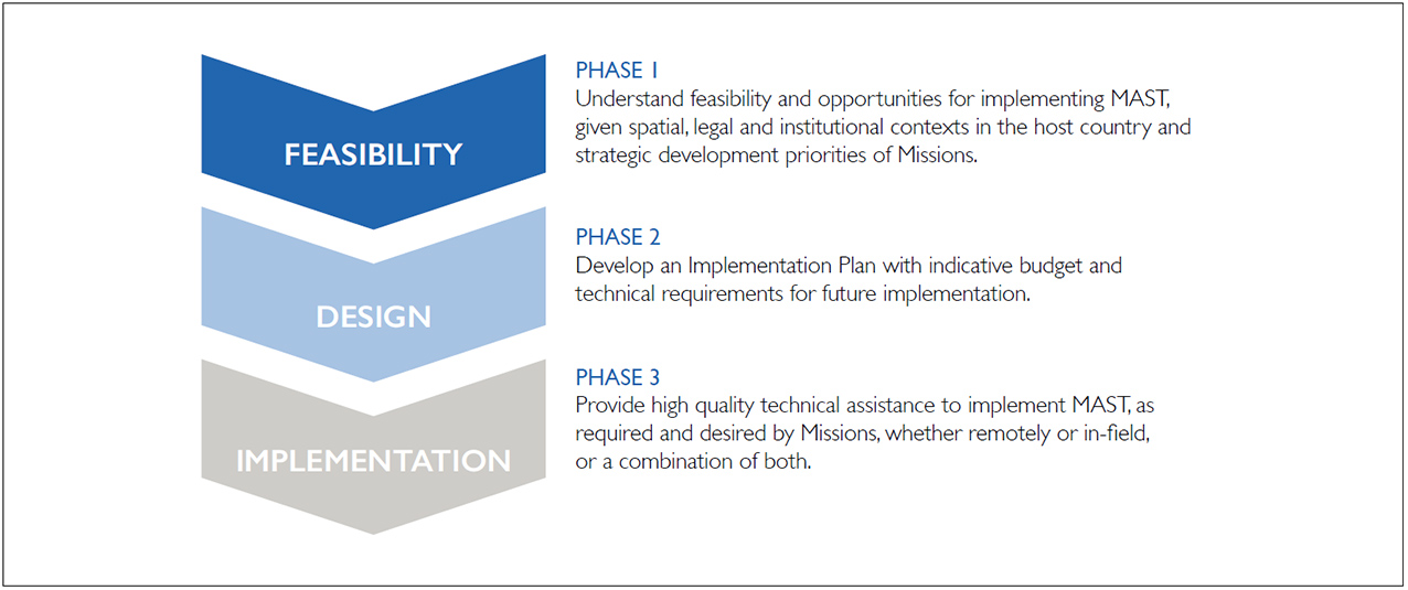
LTS begins its engagement by conducting a feasibility assessment to better understand how MAST might help a mission more efficiently achieve its goals. MAST can add value to a wide variety of projects, including those working to achieve broader development outcomes such as promoting gender equality and women’s empowerment, initiating and helping to build inclusive and sustainable markets, stimulating agricultural-led economic growth, supporting democracy and governance, and increasing resilience.

LTS’s initial assessment, which includes desk research and a stakeholder landscape assessment, will result in a report that systematically determines the feasibility and need for MAST and will outline how MAST might be implemented, whether it should be integrated into an existing or planned Mission project or become a stand-alone pilot initiative. Following the feasibility study, LTS conducts site visits to develop an implementation plan and budget. Toward this end, LTS solicits extensive stakeholder engagement to ensure that the project design and scale is informed by feedback, evidence, and requirements from the field. LTS ensures that the potential project activities are validated by all stakeholders.

Finally, LTS will ensure effective communication protocols during implementation and support partners and staff through training. Implementation oversight, whether direct or remote, will be focused on working collaboratively with partners and host governments to effectively implement and monitor project activities.

CONTACT US

For more information on accessing LTS Services, please contact Ioana Bouvier, USAID E3/Land and Urban Senior Geospatial Analyst at ibouvier@usaid.gov

or Stephen Brooks, Senior Land and Resource Governance Advisor at sbrooks@usaid.gov.

More information about MAST can be found at www.land-links.org/MAST.

Fact Sheet: Land Technology Solutions

USAID has launched a new program to expand its successful Mobile Applications to Secure Tenure (MAST) initiative. MAST is a suite of innovative technology tools that use mobile phones and tablets to help communities, civil society, and private sector actors efficiently, transparently, and affordably map and document land and resource rights to build a path out self-reliance and transformative economic development.
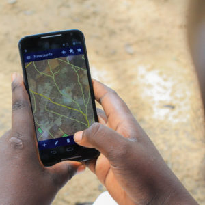
MAST provides a simple mobile platform to capture the information necessary for clarifying and securing land rights, such as names and photos of people using and occupying land, details about how they are using the land and whether the land is held in customary arrangements or through formal legal channels.

MAST combines an easy-to-use mobile phone application with training and a participatory approach that empowers citizens in the process of understanding their rights to land and resources.

WHY MAST?

MAST provides a low-cost, flexible alternative to traditional land administration services. It can be used in areas where traditional land administration services are unavailable or not functioning because of lack of capacity, funding, or political commitment. MAST can provide communities in these locations with a flexible, fit-for-purpose, and effective means of recording and documenting their land and resource rights. The MAST application runs on readily available Android phones, and can be translated into different languages and customized for local needs. MAST can be used in rural, peri-urban, or urban areas and even in areas without cell or internet connections as a tool to catalyze development.

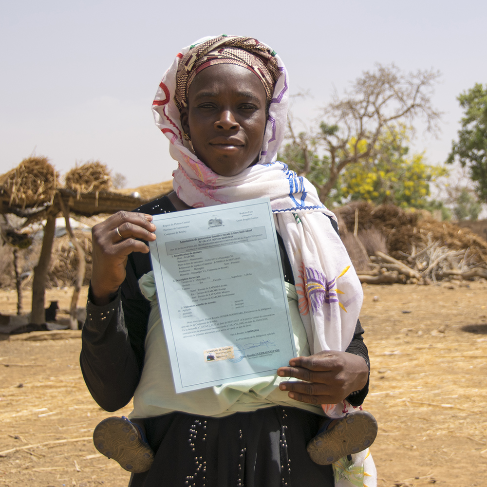
In Burkina Faso, MAST was used to successfully map and issue 2,638 land certificates in a period four months. Traditional land survey approaches would have taken significantly longer but would have been no more accurate. In Tanzania, after a successful pilot in three villages, MAST is now being scaled by the Feed the Future program and has documented more than 11,500 parcels and issued more than 4,000 land certificates. In Zambia, USAID is helping traditional leaders access MAST’s innovative tools to document and certify customary land rights in 150 villages.

WHY LAND MATTERS

Hundreds of millions of people around the world lack documented land rights. Lack of documentation weakens farmers’ and communities’ hold over their most important asset – land – disincentivizing critical long-term investments that improve harvests and lives.

Strengthening land tenure and property rights is critical for:

  • Promoting stability by preventing and mitigating conflict over land and resources
  • Creating incentives to improve agricultural productivity, reducing hunger and poverty
  • Promoting gender equality and enabling women’s economic empowerment
  • Promoting resilience and a path to self-reliance
  • Creating incentives to manage natural resources efficiently and sustainably
  • Improving governance

Due to the cross-cutting nature of land and resource rights, MAST can be used in a variety of programming contexts:

  • Feed the Future
  • Democracy and Rule of Law
  • Gender Equality and Women’s Economic Empowerment
  • Conflict Mitigation and Management
  • Economic Growth
  • Environment, Biodiversity, and Natural Resource Management

HOW TO ACCESS MAST

USAID’s E3/Land and Urban Office has launched a new program, Land Technology Solutions (LTS), that is designed to refine MAST and support its expansion into new countries. LTS is an integrated knowledge transfer, capacity building, and technical assistance program that helps eligible countries rapidly deploy a customized version of MAST either as a stand-alone pilot project or an integrated activity supporting an existing program.

SERVICES OFFERED BY LTS

  • Technical assistance in designing specialized land mapping or registration pilots or activities;
  • Assistance in supporting the creation of a country-specific, customized version of MAST that is adapted to local needs;
  • Training and capacity building at the national, regional and local levels; and
  • Ongoing technical assistance and evidence-based monitoring and evaluation support for sustaining interventions or for future scaling by host countries.

MORE INFORMATION

For more information on accessing LTS Services, please contact Ioana Bouvier, USAID E3 Senior Geospatial Analyst or LandMatters@USAID.gov