Background
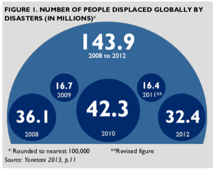 Disaster-induced displacement is on the rise. The Internal Displacement Monitoring Centre (Yonetani 2013; see Figure 1) estimates that in 2012 alone, 32.4 million people were displaced as a direct result of natural disasters or because they faced an acute threat of being affected by a natural disaster. These figures do not include populations affected by slower onset disasters such as drought and sea-level rise.
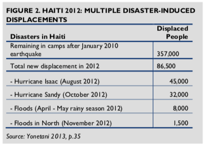
In addition to geophysical natural disasters such as earthquakes and tsunamis, over the last 30 years the number of climate-related disasters has increased (IPCC 2013; World Bank 2013a). Experts believe that such events are likely to become more frequent and more damaging (Kreft and Eckstein 2013; IPCC 2012). On occasion, some countries may suffer multiple natural disasters in one year. Haiti, for example, experienced several hurricanes and floods in 2012, which added more people to the already high number who had been displaced since the 2010 earthquake (see Figure 2 and also see GAO 2013 for a detailed discussion of challenges in resettling the earthquake-affected population).
 Given the scope and scale of this problem and the length of time it takes to rebuild after a natural disaster, it is essential to not only effectively respond to disasters, but to also secure land rights ex ante and develop sustainable strategies to reduce the land tenure-related impacts of future disasters. While providing shelter assistance is one of the primary focuses of post-disaster programming, humanitarian response teams must also understand the formal and informal land and housing rights that existed prior to a disaster. Land tenure and property rights (LTPR) issues should be examined as early as possible because without clear rights to a given piece of land, programs based on rebuilding infrastructure or resettling displaced populations will be subject to conflict, delay, and increased costs.
BOX 1. DEFINITIONS USED IN THIS ISSUE BRIEF
CONTINGENCY PLANNING: Planning focused on specific disaster events with a high risk of occurrence and high levels of vulnerability.
DISASTER RISK REDUCTION (DRR): Measures that prevent or reduce the damage caused by natural hazards such as earthquakes, floods, droughts, and storms. For example:
- Early warning systems notify people to move out of harm’s way before a tsunami hits or before a volcano erupts.
- Analysis of hazards and vulnerabilities can help communities plan where and how to build.
- Building codes—when appropriate to local weather patterns and enforced—lead to construction of structures that are more likely to withstand damage.
- Trained first responders can rescue trapped or injured persons.
- Diversified livelihoods can better protect families in the event that their primary livelihood, such as raising cattle, is decimated by drought (USAID 2014).
ENUMERATION: Collecting demographic and land rights data on populations who are typically excluded from the databases planners and land governance authorities use, such as residents of informal settlements, migrant laborers and pastoralists. Community members can conduct enumeration exercises without outside technical experts.
HOSTING: Act of a family providing accommodation to displaced families, such as allowing a displaced family to live within the home or constructing a temporary shelter in their compound.
LAND TENURE AND PROPERTY RIGHTS (LTPR): The systems that define and regulate how people, communities, and others gain access to natural resources, whether through formal law or informal arrangements. The rules of tenure determine who can use which resources, for how long, and under what conditions.
RESILIENCE: The ability to mitigate, adapt to, and recover from shocks and stresses in a manner that reduces chronic vulnerability and facilitates inclusive growth (USAID 2012).
The key to effective response, reconstruction efforts, and building long-term resilience for disaster-affected communities is to recognize the continuum of land tenure arrangements that exist in practice prior to a disaster, while strengthening the land rights of the groups most vulnerable to having insecure tenure arrangements, including women, youth, migrants, and the poor. Most relief approaches focus on groups with documentation of prior land ownership but ignore the land claims and housing investments of those who may have held land informally or who lack documentation. However, it is important that disaster workers recognize that in much of the world: 1) secure tenure is the exception rather than the norm, and 2) land claims and transactions are often informal and governed by alternative institutions. In many parts of the world, people hold rights to land that are not documented but are widely recognized as legitimate by their neighbors, nearby communities, and some national governments. When disaster strikes, efforts to resettle and rebuild should include recognition of informal rights along with documented rights.
This issue brief is intended to guide efforts to build more resilient communities both pre-disaster and during the different phases of post-disaster programming, including relief, recovery, and reconstruction. Stronger land tenure arrangements mitigate the impact of disasters on communities. This issue brief highlights specific points at which it is crucial to consider land tenure and property rights, including discussions of:
- differences among disaster-affected populations with respect to their land tenure and property rights;
- ways in which weak land governance systems exacerbate the effects of disaster on vulnerable populations;
- how proactively addressing LTPR can serve as an effective disaster risk reduction measure;
- strategies for identifying and addressing LTPR issues in post-disaster settings; and,
- specific recommendations for USAID programming.
Types of Disaster-Affected Populations
A disaster-affected population is not a homogeneous group. While natural disasters affect entire populations in an area, certain segments of a population are more vulnerable to the effects of disasters than others (Hyndman 2011; World Bank 2013b). Vulnerability to disasters increases when land governance systems discriminate against populations based on their class, ethnicity, sex, or caste (Reale and Handmer 2011). Particularly vulnerable groups include: lower-income people who settle in areas that lack sufficient infrastructure to mitigate the effect of disasters and who, as a result, may have difficulty accessing post-disaster reconstruction aid; and women and children whose weak inheritance rights may make it difficult to reclaim property after a disaster. For instance, migrants to cities, particularly lower income populations, may settle in areas that do not have the necessary infrastructure or planning to mitigate the effects of natural disasters. Further, these same populations may have difficulties accessing post-disaster housing reconstruction aid due to the reluctance of aid organizations to build permanent housing on land where the rights are unclear or contested (GAO 2013). Identifying which populations are particularly vulnerable should help USAID develop disaster risk reduction interventions that do more to build resilience (World Bank 2013b). It should also help USAID ensure that its post- disaster assistance strategies do not neglect vulnerable populations.
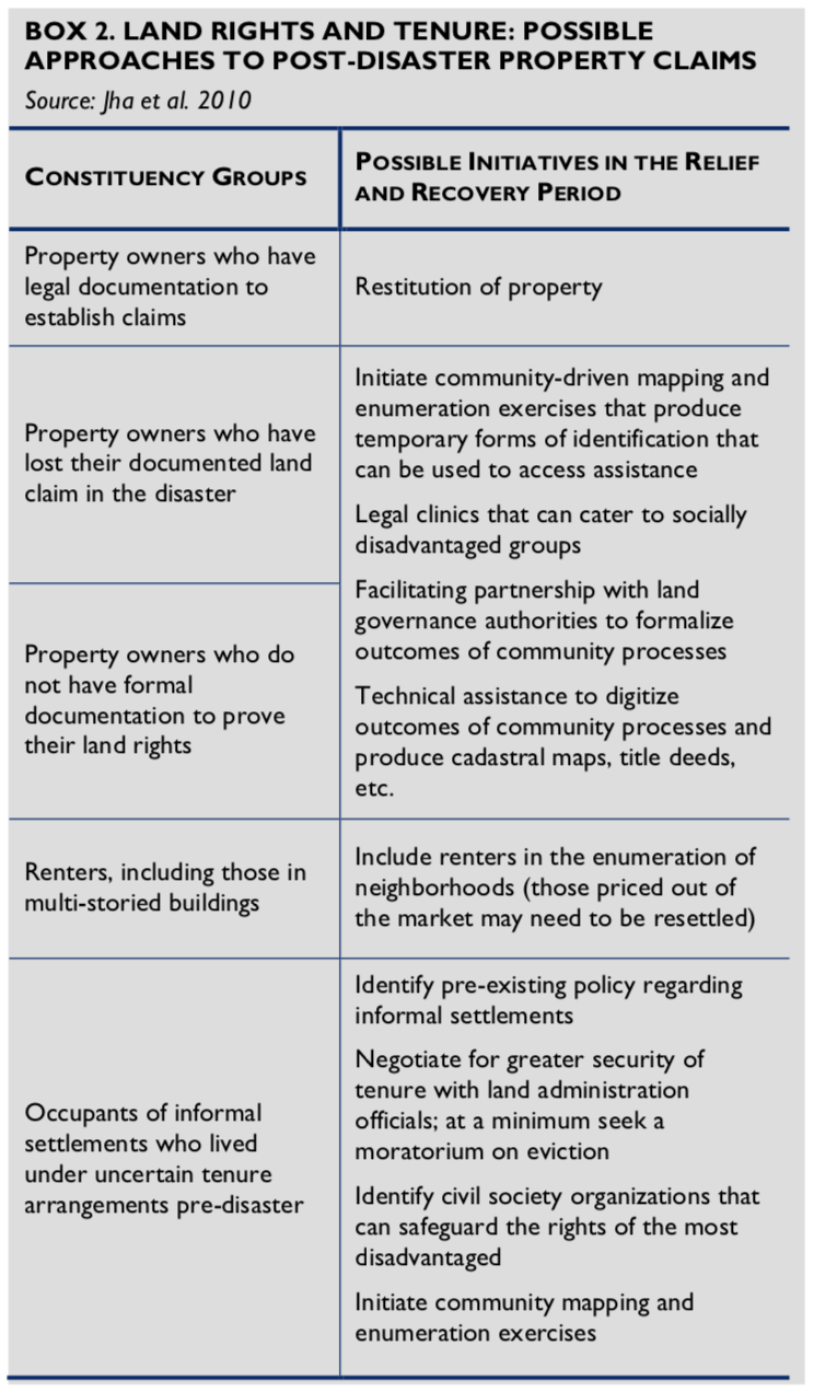 Depending on the country and context, disaster-affected populations can be divided into at least five categories with respect to their property claims: 1) property owners who have the requisite legal documentation to establish claims; 2) property owners who lost their documentation in the disaster; 3) property owners who never had formal documentation of land rights; 4) renters; and 5) occupants (owners and renters) of informal settlements who lived under uncertain tenure arrangements pre-disaster. Often times, the claims of vulnerable populations fall into categories 3 – 5, which are inherently less secure. Depending on existing social segmentation by race, class, religion, citizenship status, etc. there may be additional groups within these categories. After a disaster, restoring housing, land, and property rights to each group requires distinct approaches because each has suffered a different kind of loss. Box 2 describes possible approaches for each group. It is important to note that in all likelihood more people will fall into the latter categories because secure tenure is an exception in much of the world.
Most post-disaster efforts focus on resolving contested claims. However, only one of the five groups above is likely to have documentation to prove ownership or use rights. Adjudicating LTPR issues post-disaster can become even more difficult when land has been physically lost as a result of erosion or sea-level rise, where the land rights of certain segments of the population (e.g. women) are not socially recognized, and where land governance systems are weak. Further complicating the early post-disaster context is the potential influx of landless and insecurely tenured individuals from neighboring regions hoping to benefit from any redistributive efforts initiated in the disaster- affected regions. Potential disputes associated with such migration can be minimized through strategies such as community-based enumeration and mapping exercises (see Box 1) and accepting a range of documents as evidence for land claims (see Box 3).
Formal Land Administration Systems and Vulnerability
Post-disaster assessments and evaluations reveal that tenure insecurity and weak formal land administration systems, including poor and/or outdated land records, increase the difficulty of restoring land, housing, and property to victims of disaster (GAO 2013; Caron 2009; Lyon 2009). Property owners who have legal documentation of their land claims are a minority in many countries in the developing world. Further, in cities of the global south, new housing stock is increasingly produced through informal land and housing markets. According to the UN-Habitat’s Global Land Tenure Network, formal land administration systems may only cater to 30 percent of citizens in most developing countries. Similarly, experts suggest that only 10 percent of the land parcels found in developing countries are documented (Augustinus and Benschop n.d.). Even state-owned land may not be clearly documented (GAO 2013; Levine et al. 2012). This lack of documentation contributes to vulnerability.
BOX 3. TENURE ARRANGEMENTS THAT ARE “SECURE ENOUGH”
At a roundtable convened by the Norwegian Refugee Council and International Federation of Red Cross in 2013, a group representing the humanitarian assistance community discussed what would constitute “secure enough” tenure arrangements for post-disaster shelter and reconstruction programming. Their discussions emerged from recognition of the growing numbers of people living with insecure tenure and/or with little documentary proof of their property rights, as well as their experience with the limitations of requiring documented titles to receive humanitarian shelter assistance. While the formulation of a “secure enough” policy that humanitarian assistance actors could use is still in the early stages of development, the Roundtable defined some of the processes and products that produce “secure enough” tenure arrangements and that should prove helpful to USAID shelter and reconstruction teams operating in post-disaster situations:
- Understanding prevailing community norms of ownership and occupancy
- Engaging in community-based verification of occupancy
- Accepting property evidence through documentation of: payment of rent, utilities, taxes, etc.; investment in property; assistance from state or humanitarian organizations; displacement status
- Building on existing administrative recognition of rights and use
The limited reach of most formal land administration systems has disturbing implications for post-disaster programming. A recent audit of USAID-funded reconstruction efforts in Haiti found that USAID had difficulty “trying to secure proper land title for permanent housing” (GAO 2013: 33), which created expensive construction delays. Moreover, “although USAID officials reported that the agency had conducted due diligence and approved 15 potential housing sites in November 2010, USAID later found that the secure land titles for some of these sites could not be confirmed due to unclear or disputed ownership, and thus reduced the number of site options and further delayed site selection” (ibid: 33). A number of civil society organizations are trying to address these shortcomings by supporting methods to resolve uncertainty in land administration procedures (see Boxes 3 and 6) and putting technology into the hands of local community members to support the documentation process (Risley 2013).
Approaches to LTPR in Pre- and Post-Disaster Settings
Resilient communities are those that can “cope with both anticipated and unanticipated negative shocks” that threaten stability (USAID 2012: 12). There are environmental, social, and institutional dimensions to building resilient communities, each with important implications for LTPR programming.
The environmental aspect is perhaps the most straightforward: resilience derives from anticipating future risks and establishing environmentally sound land use planning practices that make use of local knowledge along with geophysical science and technology (see DRR section below). The social dimensions to building resilient communities address the different abilities of social groups to weather adverse shocks, claim rights, and access the resources they need to ensure their livelihoods, shelter, and sense of well-being. These differences may emerge because sex, socio-economic status, class, ethnicity, religion, or other identifiers often form the basis of discrimination with respect to an individual’s access to, and ability to exercise, land and property rights.
Institutional aspects of LTPR programming to build resilient communities include securing tenure arrangements and linking land administration systems to disaster management agencies. For example, land administration systems that invest in technical training and support for documentation, registration, surveying, and protection of land records will have more capacity to reduce disaster-related risks and respond in the wake of disaster. Given that disasters can destroy land records, risk mitigation measures such as protecting land records and creating multiple back-up files and record storage locations build resilience into the administrative system and facilitate recovery (Mitchell 2011; FAO 2012). Building land administration systems that can contribute to both risk reduction and recovery efforts requires expanding and verifying available information based on land use and ownership, as well as strengthening horizontal and vertical links within and across government agencies. In Sri Lanka, for example, post-tsunami recovery and reconstruction was slowed by confusion over land ownership among government departments in the same district (horizontal links) and communication difficulty between officials in the country’s capital, local government officials, and their intermediaries (vertical links) (Lyons 2009). This suggests that addressing land claims in a post-disaster context, especially in countries with limited or damaged formal land administration agencies, requires a primarily social rather than a technical process. The process should involve: consultations with the community, relevant customary authorities, and formal land administration agencies; an alertness to power relations within communities and between communities and government agencies; and, as needed, the creation of dispute resolution mechanisms.
Secure tenure creates the conditions for financial and infrastructure investments to “build back better.” The sections that follow discuss LTPR programming approaches that can help build resilient communities at different intervention periods: 1) before a disaster strikes (i.e. disaster risk reduction); 2) disaster response and recovery; and 3) reconstruction. In each phase, it is important to be mindful of the limitations of formal land administration systems. While local traditional or customary land governance institutions may not be legally recognized, they are generally considered to be socially legitimate and have the most accurate and reliable information on land use and ownership. Because these institutions are socially legitimate, they can provide “secure enough” tenure, which is understood as rights to land and natural resources that are not contested without reason, and that provide holders with sufficient confidence to invest in their land and reap the benefits of their investments. In other words, “secure enough” tenure creates incentives to make shelter and livelihood investments.
LTPR in Disaster Risk Reduction Efforts
Disaster risk reduction (DRR) interventions build resilience into institutions and communities. Secure land tenure and property rights are the backbone of such interventions. Resilience-building efforts rest on two essential points: 1) government institutions and humanitarian actors need to be proactive in their planning for disasters (in order to mitigate their impact); and 2) being proactive means incorporating LTPR issues into planning and decision-making before disaster strikes.
DRR interventions play a key role in minimizing the loss of life and livelihoods in disaster-affected regions and reducing the cost of post-disaster recovery. Strengthening the technical and managerial capacity of institutions governing land use and property rights is central to DRR efforts, as it generates the information and the agents that are vital when a disaster strikes, and minimizes the risk of destruction through coherent land use planning. On the technical front, advances in climate forecasting, spatial analysis, and modeling help identify vulnerable regions and, when integrated into planning for those regions, can enable proactive responses to, and reduce the impact of, natural disasters. Additionally, updating and digitizing land record systems can improve the effectiveness of response efforts and readily supply land-related information to support the recovery and reconstruction process, and prevent delays that can cost lives and money. On the managerial front, encouraging partnerships between the disaster management agencies and government land administration agencies, and between governments and local communities, can increase the probability of a coordinated response in the wake of a disaster.
Using Forecasting and Modeling for Improved Land Use Planning & DRR: Modeling attempts to forecast the potential impact of increased rainfall, storm intensity, or sea-level rise on human populations, and on various land uses in the region. For example, to address and prevent loss of life and assets associated with recurring floods and droughts across West Africa, the International Federation of Red Cross (IFRC) and Red Crescent societies integrated short-, medium-, and long-term forecasting into their disaster risk mapping and response preparedness efforts. Forecast-based action allows humanitarian actors to proactively minimize disaster impacts rather than engaging in costly response efforts (Braman et al. 2013).
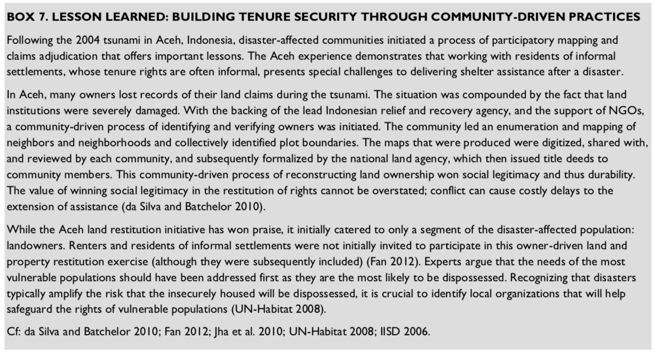
In areas threatened by slow onset disasters such as sea-level rise and droughts, as well as those repeatedly affected by floods, cyclones, or typhoons (see Figure 2), community groups and government officials can work together to build a consensus on when such areas may no longer be suitable for habitation given the risks and the costs of rebuilding. Consensus is key to compliance; affected community members need to take part in defining this threshold and any subsequent zoning decisions (see Box 7), alternative land use plans, and/or the identification of permanent resettlement sites. Community involvement is essential in identifying thresholds, as communities have strong ties to their neighborhoods and associated livelihood practices. In Sri Lanka, for example, coastal fishing communities repeatedly return to the beach after being relocated by the government, as fishing is not only their livelihood but their way of life (Caron 2009).
BOX 4. THE BENEFITS OF PLANNING AND TRAINING
In Togo, International Federation of Red Cross West and Central Africa Zone (WCAZ) combines seasonal rainfall forecast information together with an early warning system, a trained system of local volunteers, and flood contingency planning to save lives and assets. Contingency plans include identifying spaces for temporary relocation of goods and short-term evacuation. For example, with IFRC support, the community of Atiegou Zogbedji constructed an early warning system of color-coded poles in the local riverbed. When floodwater reaches the system’s yellow marker, families move their food stocks and assets to higher ground. When floodwater reaches the red marker, the community evacuates. During the 2008 floods, while there was housing damage in the community, there was no loss of life (Braman et al. 2013).
Modeling allows planners to experiment with different climate change scenarios along flood plains and river deltas, and to forecast slow moving changes such as sea- level rise. National economic development planning often proposes land use changes to meet new development objectives such as agricultural expansion, industrialization, and urbanization. Modeling, when combined with economic development planning, highlights the implications of land use change under different climate change scenarios or weather events (Van Dijk et al. 2014). For example, when agricultural land or open space is converted to impermeable surfaces, the ecosystem changes. Because concrete does not absorb water like soil does, paving can increase flooding and impact populations living in low-lying areas.
Integrating LTPR into Contingency Planning: Climate modeling and rainfall prediction help formulate contingency plans by providing information that allows people to respond and move in a more proactive and organized way. Contingency planning in the case of flooding, for example, involves identifying higher ground for people to move to when water levels rise, thereby saving lives and protecting livelihoods. For contingency planning to work, land rights and access rights must be clarified. In order to avoid conflict, use of land in the context of contingency planning must be clear and mutually agreed upon, especially if the at-risk community does not have recognized rights to use the desired space (Mitchell 2011). At-risk communities—with assistance from NGOs or the government— must approach and work with communities that own or have control over land that can be used as temporary storage or evacuation sites (see Box 4). As noted in the Voluntary Guidelines on the Responsible Governance of Tenure of Land, Fisheries and Forests in the Context of National Food Security (2012), solutions to address the LTPR challenges of one population should not disrupt the same for another population.
Inventory and Recording of Property Claims: Before a disaster strikes, land administration officials can proactively initiate their own land inventory and recording exercises. Such exercises encourage land administration officials to re-familiarize themselves with local land use and land-based livelihood strategies and to proactively record land rights arrangements. The foundation for sound disaster risk reduction lies in building a comprehensive and accessible database of both private and public land parcels, and recording their occupancy status and use. Such an inventory identifies lands at risk of flooding or erosion as well as lands that can be used for evacuation, emergency housing, post-disaster resettlement, and for temporary post- disaster debris collection. Inventory exercises that identify state land for emergency housing and livelihood activities must determine the extent to which state lands are perceived as “commons” by surrounding communities (Mitchell 2011). Gauging such perceptions is important because commons and other forms of customary land use are often neither recognized nor fully understood by land administration officials, thereby putting at risk the livelihoods of communities that depend on these lands. Similarly, donors can do a great deal to reduce risks by supporting community enumerations.
The inventory and recording of property claims within informal settlements, however, could create uncertainty. Residents of informal settlements often fear that DRR plans serve as a pretext for eviction rather than an opportunity to engage in a process of gaining secure tenure and building resilient communities. It is therefore important for institutions to recognize that the value of land inventory and recording exercises lies not only in the inventories they produce but in the opportunities that they create for extending secure tenure. Land inventory exercises provide opportunities for officials to review key laws and regulations governing land and property rights and examine how they may be used or revised to create secure tenure conditions for the growing populations that live in informal settlements and rely on informal housing.
LTPR in Response and Recovery Efforts
Immediately following a disaster that displaces a large number of people, states and humanitarian agencies focus on providing temporary shelter, food, water, sanitation, and related assistance. Typically, these goods and services are provided through centralized delivery to displaced persons living in camps, or in a more decentralized fashion through host families. However, land tenure is often a missing element in the planning for both types of sheltering arrangements. Even beyond the immediate response phase, the LTPR dimension of recovery efforts tends to be missing. Officials involved in reconstruction often do not prioritize land tenure issues, electing instead to focus on rebuilding homes and infrastructure. Land issues are categorized as “other economic factors outside the construction sector” (Lyons 2009). The danger of this approach is that it obscures the importance of preliminary steps—such as resolving conflicts over land requisitioned for reconstruction—before building begins. The sustainability and effectiveness of response and recovery efforts depends in large part on anticipating and planning for the LTPR challenges that emerge in the wake of a disaster. Hence, this section discusses how to incorporate LTPR into post-disaster programming.
BOX 5. POTENTIAL DISASTER-RELATED LAND TENURE CONFLICTS
The approaches described in this brief can mitigate the following conflicts, which are meant to be illustrative—not exhaustive.
- Powerful vested interests expropriate land (large investors acquire coastal beach areas for tourism development)
- Land is re-zoned, prohibiting reconstruction (displaced groups encroach on the land of others)
- Property boundaries are washed away and there are no formal records (there is no way to adjudicate ownership once people return to their land)
- Uncertainty about the speed of the reconstruction process and the length of hosting arrangements (stress and tensions arise between the displaced and host families)
Camps: Camps might be erected on either state or private land. In identifying land for internally displaced people (IDP) camps, it is important to first clarify land use and ownership in targeted areas and to consult with relevant stakeholders. This will help to avoid conflicts between IDPs and host communities, and clarify conditions regarding access to and use of the land.
Hosting: While hosting displaced families is a well-established informal practice, humanitarian agencies increasingly consider it to be a cost-effective shelter alternative to large camps (Davies 2012; Setchell 2012). Following the 2010 Haiti earthquake, approximately 500,000– 600,000 persons (or 30% of the displaced) lived with a host family (IFRC et al. 2010). Hosting-related assistance takes a variety of forms. Sometimes host families receive minor financial support to repair their home so that it is more habitable for hosting a displaced family. Alternatively, a displaced family might receive shelter materials to construct a temporary shelter in the host family’s yard or on a piece of land owned but not occupied by the host family. However, given delays in the reconstruction and resettlement process, it is often unclear how long families might live in a hosting arrangement. This uncertainty creates the need to clarify land tenure implications of temporary hosting arrangements, and create a process through which host and displaced families may establish a clear understanding of hosting expectations. Topics for negotiation might include how long a displaced family may stay, what “use rights” the displaced family has (i.e., access to water, use of fields), and an agreement that prolonged occupancy by a displaced family will not threaten or challenge the host family’s rights.
Restoring Property Loss: When people lose homes and property in a disaster, they turn to government, donors, and humanitarian agencies to restore their losses. Two main factors influence a claimant’s ability to access such support: 1) his or her land tenure status at the time of the disaster; and 2) his or her position in society based on sex, ethnicity, socio-economic status, and the subsequent social networks and access to power that these enable (World Bank 2013b; Levine et al. 2012; Caron 2009; Yonder et al. 2005).
The tenure status of residents of a disaster-affected region will be wide-ranging (see Payne et al. 2014 for an example of a tenure status continuum). Post-disaster tenure can also be confusing and chaotic, particularly in the absence of formalized claims. For example, in Haiti, fieldwork indicates that after multi-story buildings collapsed, people who occupied the ground floor had the “first right” to stay on the land where the building once stood, while people on higher floors had more difficulty asserting their housing rights (Macintyre 2010). It is likely that national policies governing restitution and compensation for losses and resettlement will only recognize the land claims of a small proportion of the population, i.e. landowners who can furnish legal documentation of their land claim (see Boxes 2 and 3). A resilience-based approach to post-disaster recovery recognizes and addresses the limitations of narrow approaches that ignore the land claims and housing investments of people who held land informally or who lack documentation.
BOX 6. BEST PRACTICE: THE HAITI PROPERTY LAW WORKING GROUP (HPLWG)
Before the earthquake, “less than 38 percent of all property in the metropolitan area of Port-au-Prince had properly registered titles” (HPLWG 2012: VII).
Using a participatory process of stakeholder meetings held in three languages (Creole, English, and French) and in rural and urban locations, the working group brought together key members from government, financial and insurance institutions, NGOs, notaries, surveyors, lawyers, and donor agencies, and in 2012, published a Land Transaction Manual “to assist the business and reconstruction communities by clarifying the current legal and customary procedures and standardizing, in writing, the legal procedures necessary to transact and assemble land in Haiti” (ibid: VIII).
This manual is a useful guide because it presents—in simple language supplemented by graphics—the steps that must be taken to buy, sell, or transfer land, and presents clear definitions of the technical terms individuals will encounter in the land purchasing or transfer process.
At the national level, housing, land, and property restitution and compensation policies should address the needs of the range of constituency groups described in Box 2. Enumeration exercises undertaken at the earliest point possible can help planners and policy makers think through the complex nature of rights, access, and tenure security in densely populated urban areas by clarifying and restituting land claims, which can allow for more rapid resettlement and reconstruction.
Community-Driven Enumeration Exercises: Community-driven participatory enumeration exercises (see Box 1) document land tenure relations that might not be known or well understood by outsiders, especially local practices that community members consider to provide “secure enough” tenure. These exercises create the foundation for social and economic resilience by using local knowledge to clarify kinship ties for inheritance purposes, increase community ownership over the land rights documentation process, and promote place-based networks (Archer and Boonyabancha 2011; Menon 2010; LaLone 2012). Partnering with formal government authorities in conducting enumeration exercises can amplify their impact (see Box 7). In Sri Lanka, decentralized recovery programming leveraged local knowledge in ways that facilitated resettlement and local economic development opportunities. Local families identified “small plots of land sited in effect as urban infill, identifiable only with local knowledge and realizable only with local negotiation” (Lyons 2009: 396).
LTPR in Reconstruction: Building Back Better, Zoning and Land Markets
“Building back better” and creating post-disaster resilience is often equated with building physical structures that are able to withstand future natural hazards. However, strengthening the governance of land and housing tenure is an equally important part of building resilient communities. It is essential to consider how post-disaster policy making can change access to land in ways that not only affects where reconstruction is allowed to take place, but also who is allowed, or financially able, to rebuild. Post-disaster zoning, therefore, is a policy-level decision that affects how communities access assistance and where families are able to re- establish their lives.
Incorporating LTPR into Zoning: After a disaster, affected areas may be re-zoned as environmentally vulnerable, buffer, or no-build zones. Any of these zoning actions can displace residents of formal and informal settlements who once lived there. The re-zoning of affected areas may become politicized, and expropriations or resettlements may be interpreted as efforts to reallocate land to more powerful interests, especially when the communities affected by new zonal boundaries are poor and/or politically marginalized. The political nature of zoning becomes evident when zoning draws new boundaries that reflect the racial or ethnic tensions in a country (especially in conflict-affected areas), or when zoning regulations are inconsistently applied along ethnic lines or are changed as the reconstruction process evolves (Lyons 2009; Hyndman 2011).
In the case of Sri Lanka’s post-tsunami reconstruction process, the constantly changing width of the country’s no-build coastal buffer zone not only delayed the construction process, but also changed the type of assistance that affected families received (Lyons 2009). The assistance—either money to rebuild their home or relocation to a new village through a humanitarian organization that provided a new home— depended on whether the loss occurred inside or outside of the buffer zone. When the width of the buffer zone decreased from 200 meters to 100 meters, families found themselves under new reconstruction rules and lost access to assistance while they were in the process of rebuilding their homes. As buffer zones changed overnight, so did affected families’ access to assistance and ability to reconstruct their lives.
Rebuilding and Post-Disaster Land Markets: Disasters affect the demand for, and supply and cost of, housing and land. As discussed above, different segments of disaster-affected populations need different recovery assistance programs because shifting market dynamics may limit the ability of some groups to recover and adapt to the external shock of a disaster (World Bank 2013b; Lyons 2009; Caron 2009). Even if vulnerable groups’ land and housing rights are recognized and restored through the issuance of documents and they are able to return to their property, changing market dynamics may erode their ability to stay on that land. It is well documented that the price of building materials and labor increase in post-disaster environments (GAO 2013; Lyons 2009). Often families who cannot afford to rebuild are forced to sell their land and move. As a result of this secondary “displacement,” families might find themselves tenure insecure once again. Such groups may not have previous experience in the land market, or understand the process of buying and registering land or the technical language associated with land administration (i.e., survey, deed, plan) (see Box 6; Caron 2009). Meanwhile, renters also often face much higher rents in the immediate post- disaster housing market and may be forced to move away from their livelihood activities.
Finally, forms of dispossession like private land grabs and encroachment complicate post-disaster reconstruction. There is a high degree of confusion in the immediate wake of a disaster. Government agencies redirect attention to relief and recovery efforts, creating a void in governance. Quite often, powerful real estate interests rush to fill these voids and acquire large tracts of land owned by vulnerable groups. Displaced vulnerable groups may have to contend with the secondary occupation of their properties by other displaced persons, which prevents their “rightful” return. Given the limited reach of formal land administration authorities, civil society advocates for socially marginalized groups play a crucial role in monitoring and protecting against the risk of dispossession faced by the poor and other vulnerable communities (UN-Habitat 2008). Community-driven enumerations have proved to be effective in strengthening the land claims of the poor and warding off encroachers. Governments and donors can also plan for dynamic price fluctuations of construction costs when designing reconstruction projects and financing schemes (World Bank 2013b).
Recommendations
When planning for and investing in DRR programming or responding to disasters, one should consider a few broad courses of action:
General Recommendations
- For detailed guidance, refer to existing manuals that show how to address LTPR in both disaster risk reduction interventions and in post-disaster relief, recovery, and reconstruction, including Jha et al. 2010; UN-Habitat 2010 and 2008; Mitchell 2011; FAO 2012.
- Designate a disaster contact person at the regional level who will maintain an index of the manuals above and will be trained in how to address LTPR in both disaster risk reduction interventions and in post- disaster relief, recovery, and reconstruction.
- Protect land records in registries and cadastral offices.
Disaster Risk Reduction Interventions
- Fund activities that encourage proactive, collaborative contingency planning with government authorities at the community and regional levels, rather than reactive management activities.
- Support community enumeration activities.
- Support efforts to review and improve regulatory requirements—such as zoning and construction codes—that could hinder rebuilding efforts.
- Assist governments in establishing or improving working relations between land ministries, departments that manage cadastral registries, revenue offices, and disaster response offices.
- Create multiple back-up files and storage locations (including cloud-based if possible) for land records such as maps, titles, and land use plans.
- Develop, at the national and sub-national level: 1) policy coherence between DRR programming, humanitarian, and development assistance; and 2) institutional coherence between disaster management agencies and land administration agencies by fostering land administration capacity building and enumeration exercises that build horizontal and vertical linkages with the land administration system.
- Promote land use modeling and climate science as part of national economic development planning in order to pay more attention to how land use conversion (agriculture, industrialization, and urbanization) intersects with different climate and weather event scenarios.
- Integrate LTPR into contingency and strategic DRR planning, including land use planning and modeling, and vulnerability assessments.
- Identify state lands to be used for IDP camps, short-term shelter, or livelihood use areas (grazing livestock, for example) as part of community-level contingency planning.
Post-Disaster Response, Recovery, and Reconstruction (0-24 Months)
- Review building codes and land use regulations in order to understand the existing legal and institutional land tenure landscape.
- Support efforts to provide just, fair, and prompt compensation in cases where people lose legitimate rights through expropriation processes or due to condemnation of property (see FAO Voluntary Guidelines chapter 16).
- Address tenure arrangements in damage assessment frameworks and take advantage of the window of opportunity that a disaster provides to work with government institutions to address issues of land registry maintenance.
- Determine what products and processes are acceptable alternatives to documentary proof of land ownership or occupancy, so that shelter and housing assistance can be extended to those living in informal settlements, under customary tenure practices, or without documentation of property rights.
- Promote community-based enumeration exercises as early as possible after a disaster, especially in urban areas, where multiple forms of tenure security co-exist. Document the existence of unique local, place- based forms of tenure in order to facilitate resettlement and reconstruction activities.
- Anticipate the risk of dispossession that vulnerable groups such as widows, renters, and pastoralists face in the immediate wake of a disaster and work with local organizations to assess their socio-economic needs to prevent them from being rendered landless and homeless. Pay particular attention to the inheritance rights of widows and children, and integrate these rights into reconstruction programming as appropriate to strengthen tenure security over the long term.
- Create legal clinics that cater to populations that might be considered at-risk, such as: 1) populations who do not have documentary proof of their land rights or whose land rights may not be considered socially legitimate; (e.g., women, children, orphans, or forms of community-based ownership); 2) illiterate populations; and 3) other groups who are not familiar with the land administration system.