Today These Families are Happy with the Land Restitution Policy

Q&A with the Land Restitution Unit’s regional director for Sucre, Bolívar, and Córdoba

Originally appeared on Exposure.

In the region of Montes de María, in northern Colombia, citizens have filed more than 6,000 land restitution claims. To date, the government has processed 85% of them. Judges have issued sentences restituting some 4,000 hectares to 300 families. In this interview, Álvaro Tapia Castelli, the Land Restitution Unit’s (LRU) regional director for Sucre, Bolívar, and Córdoba, speaks about the support that USAID’s Land and Rural Development Program has provided for the restitution process and the LRU’s plans to resolve all remaining claims in 2017.

____________________________________

Q: What characteristics have made Montes de María and the LRU’s mission unique?

A: Since the creation of Colombia’s land restitution policy, Montes de María has been characterized by a large number of restitution claims, especially in municipalities like Ovejas and El Carmen de Bolívar. And at the same time, our regional LRU office has suffered from a shortage of personnel, which prevented us from processing claims systematically and efficiently.

Q: USAID began partnering with your office in 2013. How has the partnership helped the LRU attend to restitution claims?

A: Thanks to USAID, we have enjoyed the support of professionals who could help us accelerate the various phases of the restitution process, including the administrative and judicial phases. The support has allowed us to resolve a large number of pending claims, which has allowed us to be able to provide timely responses to the families seeking the restitution of their land. I would say of the more than 6,000 claims in Montes de María, about 15% were processed with the support of USAID’s Land and Rural Development Program.

Q: Where did USAID and the regional LRU office combine efforts to increase land restitution processes?

A: We were able to push forward about 150 cases for people in the village of Macayepo and in the mountainous area of Bolívar. Today, many of these cases have received rulings from restitution judges. Last year, judges delivered 77 rulings that called for the issuing of property titles for families who were forced to abandon their lands, and some of these parcels have already been formalized. Thanks to USAID, today these families are happy with the land restitution policy.

Q: What are some of the challenges in working with the municipalities in terms of attending to restitution beneficiaries?

A: Before, everyone seemed to think that the restitution policy was the sole responsibility of the LRU. We know that there are a series of entities that participate in the process—these are the entities that make up the SNARIV [1]. And for the case of the regional entities, if we hadn’t had a rapprochement with them in terms of organizing participatory forums where they could learn about the restitution policy and their responsibilities in this regard, it would have been quite difficult to implement the policy at the regional level.

Q: Have you been able to change this perception?

A: Yes, we were able to strengthen interinstitutional coordination in the region, which allowed us to address the issue of secondary occupants. This is an extremely important issue that we wouldn’t have been able to address without USAID’s support. USAID opened up channels of communication with the Ombudsman’s Office, the departmental government, and even mayors’ offices in order to lend support to secondary occupants—families who had nothing to do with abandonment and displacement, but are nonetheless involved in the restitution process.

[1] National System for Comprehensive Victim Support and Reparation.


Customary Land Certification Reaches Zambia’s Vulnerable Populations

When Ireen Sakala, a smallholder farmer in Mkanda Chiefdom, heard about a new effort to document land ownership, she feared that as a disabled, single woman, she might be excluded. Confined to a wheelchair since childhood and unable to find employment, Ireen depends on land inherited from her parents for her family’s livelihood. Her land, like most rural land in Zambia, has no documentation and is administered through inheritance from family and verbal histories under the authority of a village headperson and the chief. With a growing population and increased land scarcity, pressures on property rights and land security are rising.

Since 2014, a local civil society organization, the Chipata District Land Alliance (CDLA), with USAID support, has helped chiefs and hundreds of villages document land allocations and provide land certificates to Ireen and hundreds of other villagers. Ireen joined her neighbors, including thousands of women, in having her land rights documented. Holding her certificate, Ireen noted, “I am very happy that equal opportunities are being accorded. I now have a certificate to my field issued in my name and I have registered my daughter as a person of interest to my land. I feel my daughter’s future to use my land is guaranteed.”

Elected as the Secretary of the Village Land Committee, Ireen has now undertaken a leadership role administering the village land register to help others in her community access the same rights she has gained.

Working with organizations such as the CDLA, Zambia’s traditional leaders and government are recognizing the benefits of strengthening community and household land rights. With over three-quarters of Zambia’s land falling under customary tenure, leadership and support from chiefs and chieftainesses creates optimism for the future in farmers like Ireen.

Getting the Lay of the Land

A municipal land formalization strategy promotes land security in Colombia’s post-conflict

Originally appeared on Exposure.

USAID AND LOCAL GOVERNMENT PARTNERS CREATED A MUNICIPAL LAND OFFICE TO TACKLE THE TITLING OF MORE THAN 4,600 PARCELS IN SANTANDER DE QUILICHAO. BY BUILDING CAPACITY AT LOCAL LEVELS OF GOVERNMENT, RURAL MAYORS AND THEIR TEAMS ARE EQUIPPED TO CONFRONT LAND INFORMALITY HEAD ON.

At the end of 2016, an infrastructure project in rural Santander de Quilichao was on the brink of losing its funding. Local government officials faced the threat of having to return over US$50,000 if the project’s property was not formalized as municipal property. The project, which was already finished and bringing potable water to over 800 users, was being financed under an agreement with Cauca’s departmental government.

The municipality did something it had never done before: titled a public property in just nine days.

The municipality’s recently created Land Office produced a property title before New Year’s Day 2017, and the investment was saved. The infrastructure project was the office’s first challenge, and its three-man team responded swimmingly.

“The municipalities of Northern Cauca have a lot of needs in basic sanitation, energy, and infrastructure. They are very rural, and overall there is little money flowing in—so if the municipality can obtain funding and is willing to make the investment, the last thing we need is to miss the opportunity due to our inability to register the property,” explains Jaime Andrés Devia, legal assistant in the Land Office.

Santander de Quilichao’s Land Office, which is the result of a partnership with the USAID-funded Land and Rural Development Program, is already playing a critical role in the municipality’s land administration processes and in promoting awareness on how to formalize land rights among the area’s 100,000 residents.

Perhaps most important, the office acts as a link with Colombia’s National Land Agency at a time when the government is poised to formalize land tenure on a massive scale as part of the commitments made in Colombia’s peace agreement with the FARC. The ongoing decentralization of land administration tasks means that the government is placing a larger responsibility on departmental and municipal governments to support to land formalization, land restitution, and rural development.

“When the Land Agency decides on its strategy and how it will carry out massive formalization throughout Colombia, Santander de Quilichao will have a great deal of the work done, especially thanks to the Municipal Formalization Plan,” says Devia.

The plan, a result of USAID’s institutional strengthening programming, is an official roadmap for the Land Office. In Santander de Quilichao, there are an estimated 4,600 informally owned private parcels. This number represents 62% of all parcels eligible for titling in the municipality, which has over 30,000 parcels. However, many of these are collectively owned by indigenous and Afro-Colombian communities and cannot be titled by the municipal government.

There are also more than 200 untitled publicly owned lands, such as schools and health centers, around the municipality. The new office has made titling 100 of these a top priority in 2017, a necessary step to respond to the needs of citizens who live on untitled urban lots and lack basic services.


Ask the Expert: An Interview with Zemen Haddis, USAID

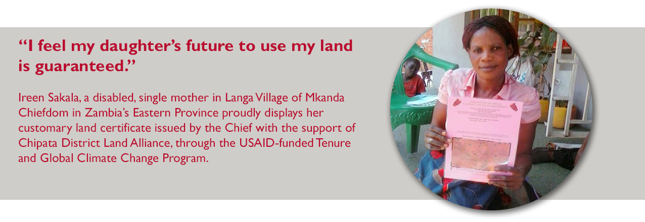
Zemen Haddis, PhD, is the Senior Agriculture Policy Advisor for USAID/Ethiopia and he manages USAID’s LAND project, which focuses on the land rights formalization process in Chifra and Amibara woredas (administrative zones similar to counties) in Afar Ethiopia.

The project works with pastoral communities in Ethiopia to support the formal recognition of customary land rights and strengthen the capacity of formal and customary pastoral land administration and land use institutions. LandLinks caught up with Dr. Haddis at his office in Ethiopia to learn more about his take on the Afar impact evaluation and how the project is engaging pastoral communities and the government around strengthening effective land and resource governance. Here is what he had to say:

Here is what Dr. Haddis had to say (this interview has been edited and condensed for clarity):

“The intervention in Afar was designed to pilot land demarcation and certification in the names of communities and to assist the Government of Ethiopia in establishing a system [for certification] that is accountable and transparent while at the same time empowering the customary institutions.

The project works with the regional Afar government and the pilot is in two woredas, Ambara and Chifra, which have different characteristics; Amibara is more agro-pastoral area with some land allocated for investment, Chifra, on the other hand, is more pastoral and grazing areas. Even though these are different geographic areas, many of the challenges are the same.

One challenge is that the Afar region would like to implement a land use plan that allocates land for grazing, crop production, investment, and other purposes—this shrinks the natural grazing system in pastoral areas. Communities would like to keep this impact on their grazing land as small as possible. We are trying to pilot this project in certain kebeles [local neighborhood governments] where it is not a government priority to allocate land for farming and where the pilot can show how beneficial this kind of land demarcation and certification is for both communities and the government.

We are trying to create a middle ground for communities and government to secure tenure rights together. Communities are trying to get back their control of resources at the same time government officials have been attempting to implement a land use plan that would give the government some decision-making role in land allocation for development purposes on communal lands.

In many places, the government allowed the administrative structure of many kebeles to be according to clan structure. As a result clan leaders in these areas can have an administrative role within both formal and customary systems. This made clan leaders accountable to both the government and to the customary system, which creates some difficulties in differentiating between formal and informal structures.”

What are some of the unique situations you find working with pastoralists?

“The model we use was designed to maintain pastoralists’ access to large grazing areas, because of the nature of their livelihood. A clan may have its own territory but may need permission from neighboring communities to use land seasonally. Pastoralists need this kind of arrangement to be able to utilize large areas to support their livelihoods. Sometimes large farms affect their movement. In many grassy areas, there is also the invasion of the harmful Prosopis bush [an invasive plant that has expanded into some of the best grazing areas].

Many pastoralists are shifting away from cattle production to sheep and goats because of lack of resources and grazing areas. This shows there’s a need for more management of the grazing areas and customary leaders, which are in a better position to manage these areas than the government, don’t feel empowered to manage them at the moment.”

What are the lessons learned, and what advice would you give to others working in pastoral areas?

“One challenge is a perception problem. Pastoral populations are few in number, but use large tracts of land—this is the nature of their livelihood—and they need to move from one place to another to access resources such as water points and different pastures during the wet and dry seasons. People may not understand this and all too often think that they may not need to consult anyone to use open areas of land for investment; even the local people sometimes believe this. One of our take-aways from this intervention is that frequent consultation and discussion with communities is very important in understanding the lives and livelihoods of these communities.

We also need to continue developing awareness of stakeholders who would like to work in pastoral areas and within the pastoralist communities themselves. And the regional government could help train communities, sharing information with the whole community, and support efforts to make sure leaders are accountable; that compensation is for the whole community; and that all members of the community—especially women and other vulnerable groups—can benefit.”

What are some of the challenges that female-headed households face under customary systems in Afar? 

“Normally men come to discussions but you don’t see women or even youth attending and voicing their interests. There is a strong influence of customary leaders and heads of households, making it unlikely that women will be vocal about their interests even when we are soliciting their opinions. This [finding] is in the baseline report. Because of the influence of traditional life, women are not in a position to understand and ask for their rights. In one instance, a woman in Chifra told me that she believed this oppresses women in her community, she said, “This is the first time I am telling anyone because our religion and tradition doesn’t allow women to come out and talk about their problems.”

These beliefs mean that we need to devise different mechanisms that will allow us to better approach women and understand their situation to better resolve their problems. And we need to have an understanding of customary leaders and their communities to get their support if we want to resolve these problems.”

What do you think governments should know to encourage them to provide pastoralists with access to their lands? What examples of successful policies have you seen for pastoral communities?

“Secure ownership of pastoral areas is the first step that governments could take. If pastoralists feel a lack of ownership, they will not be in a position to monitor and take care of their grazing areas. They may fear that land can be taken at any time by the government or by investors, which does not encourage these communities to manage it well.

The government and communities could work together to develop by-laws to establish a better sense of ownership in these areas, this may include consulting with communities before using land for a public purpose and land could be allocated for investment by taking into consideration the interests of the communities. Both government and communities could use a model where the communities are consulted and benefit from any land taken from them and pastoralists are empowered to manage their land. If there is a sense of ownership pastoralists can manage the land; if there is no sense of ownership, I believe, we may see very bad deterioration in the future.”

What would you recommend to others who are interested in working with pastoral communities to secure land rights – or rights to pastures, water sources, migration routes?

“We need to be innovative in our approach to pastoral areas. First, we need to understand the interests of both parties, governments and communities, and find a way to accommodate these interests, We need long-term plans so that government officials in particular can understand how beneficial and empowering secure land rights are to communities.

One of the objectives of the pilot is to show that there’s another way of working together. In Ethiopia, according to the law, the government has all the rights to land. Pastoralists may not understand this because they are only familiar with customary laws, which can lead to conflicts. We need to bring these two groups together to help them understand each other and find “common ground.”

When it comes to land management, allocating land for grazing, forests, or other purposes, has to be done at the community level for it to be done in harmony with both customary and formal land laws. Finding a point of compromise is very important; then government officials can work with the customary institutions more closely.”

USAID has supported the development of the impact evaluation on the Afar project. What information from the baseline report did you find interesting?

“The baseline is very interesting. I had the opportunity to talk with clan leaders before the baseline report and at the time, I had the impression that they had lost their land and that they were very disappointed by the lack of government protection on the ground.

But now I understand that there is no significant claim of land taking for investment without the consent of communities and the baseline tells us that the Afar people were relatively happy and protected. We need to understand this better in the future. The pastoral context is a complex situation so we should not assume anything; we need to continue to learn more.

Going forward, the project can continue with demarcation and improve the awareness of communities and we can see what kinds of changes of perception in terms of benefit arise. I’m optimistic that this intervention may improve perceptions towards communal land administration and management over time in the project area.”

Is “Secure Enough” Good Enough for Land Tenure? A Case Study from Rwanda

Originally appeared on Chemonics’ blog.

What is “secure enough” tenure?

The concept of “secure enough” tenure has been discussed in the context of humanitarian and post-disaster programming and increasingly through donor initiatives. In our new paper, we adopt the following definition of secure enough tenure, used by USAID: “[T]he benchmark of tenure security [is] when rights to land and natural resources are not arbitrarily contested by the state, private entities, or others and that people have incentives to invest and reap the benefits of their investments.” Under this definition, the formalization of land rights is not always the ultimate objective, but rather one component of an approach whereby secure enough tenure supports participation in economic development, while mitigating against the loss of land rights and access in an ever-changing global economy and environment.

Why is secure enough tenure a useful concept?

Security of tenure cannot be measured directly and is largely a result of perception. While useful for the inclusion of customary tenure and institutions in considerations of tenure security, the concept of secure enough tenure is profoundly subjective. If the boundaries for establishing secure enough tenure are overly lax, the concept has little meaning — too many cases may be accepted as secure enough when they are not. If the bar is set too high, few cases may qualify. Furthermore, there is a range of possibilities for interpretation and negotiation around what constitutes secure enough tenure.

Despite the challenges associated with the secure enough tenure framework, it is very useful for situations in which formal and informal tenure systems operate simultaneously. We argue that it is also useful in situations in which the state’s visions for agricultural and national development are not in perfect harmony with social and economic realities, as our evidence shows to be the case with land tenure in Rwanda.

Case study: Is land tenure secure enough in rural Rwanda?

In Rwanda, most households depend on land and agriculture for their livelihoods. Low agricultural productivity remains a challenge due to land scarcity and agricultural intensification strategies that have exhausted the country’s natural resources. Following the Rwandan genocide, the government of Rwanda established a vision for the country’s development based on registration of land rights and agricultural transformation. The Crop Intensification Program (CIP), Land Use Consolidation (LUC), and Article 30 of the 2013 Land Law restricting land subdivision were key.

While increasing yields of select crops, the CIP and LUC have been linked to reduced decision-making authority over land and, in some cases, decreased tenure security for participating landowners. Similarly, preliminary evidence suggests that Article 30, which rests on the assumption that agricultural parcels smaller than one hectare are unproductive, may force farmers into informality rather than successfully preventing subdivision.

Our paper, Is Land Tenure “Secure Enough” in Rural Rwanda? prepared for the World Bank Conference on Land and Poverty, draws on a literature review and original research conducted in Rwanda under the USAID Rwanda LAND project and applies a secure enough tenure framework to assess how land tenure security and agricultural outcomes may be improved for rural landowners while also contributing to the government of Rwanda’s ambitious vision for agricultural development.

Our analysis explores whether tenure in Rwanda is secure enough for landowners to invest in their land and recommends opportunities for future improvement. Given demographic and economic pressures facing the country, the government of Rwanda seeks a technical solution to the challenge of producing enough food to feed its population, enabling a shift from an agrarian to a more urbanized, mixed economy. However, to ensure that landowners feel secure enough to invest in their land, recognition of the realities of parcel size, demographics, and culture is key. So, too, is maintaining the benefits achieved through the Land Tenure Regularization Program (LTRP), which resulted in increased tenure security for female and male landowners in Rwanda.

Informal subdivisions and transfers associated with implementation of Article 30 of the 2013 Land Law also have implications for the sustainability of the LTRP and the Land Administration Information System (LAIS), Rwanda’s database for land parcel information. Because of these restrictions and other barriers to registration, many land transfers in rural areas remain informal. A World Bank study found that 47 percent of transfers for newly acquired land have not been registered, which may be due to high registration fees, but also to lack of awareness of regulations and restrictions on subdivisions, confirming the Rwanda LAND project’s own findings.

Nonetheless, evidence shows that tenure for even informal landowners is currently secure enough to facilitate their investment in land. When perception of tenure security is high — as in Rwanda, regardless of whether the landowner holds a title certificate — landowners are still likely to invest labor and capital to improve and maintain their land. Indeed, investment in soil conservation — particularly among women — increased following the LTRP.

However, emerging threats to tenure security may have consequences for household investments in agriculture, should landowners’ perceptions change. When perception of tenure security is low, investment and productivity decrease. If the Land Administration Information System is not maintained, the benefits of the LTRP and the value placed in registration may diminish as actual land ownership is not reflected in the registry. Over time this will erode security. At the same time, increasing competition over land from other farmers, international investors, and even the government of Rwanda could compound threats to tenure security associated with land disputes and expropriations for those landowners that have not registered their rights. Were this to happen, perceptions of land tenure security could decrease to the point whereby tenure is no longer secure enough for households to optimize investment in agriculture.

Conclusion

We argue that while the LTRP markedly increased land tenure security for women and men in Rwanda, agricultural policies designed to transform the agricultural sector have produced emerging threats to tenure security with potential implications for future economic development and even stability. Using the frame of secure enough tenure, we recommend that the government of Rwanda consider enabling rural landowners to progressively formalize their land, while allowing for the continuation of customary practices (such as the inheritance practice of umunani) that represent cultural values and respond to immediate livelihood security and economic needs. Doing so may help maintain the great wins in economic development and stability already made by the country, while maintaining progress toward the government of Rwanda’s vision for development.

Read the full paper, Is Land Tenure “Secure Enough” in Rural Rwanda? for more information and a full list of references.

Ask the Expert: An Interview with Heather Huntington, Cloudburst

LandLinks caught up with Dr. Heather Huntington, Land Tenure and Natural Resource Management Impact Evaluation Specialist with The Cloudburst Group to discuss a key research paper on tenure security that she has been developing under USAID’s Evaluation, Research and Communication (ERC) Project. The research compares datasets across seven impact evaluations in customary systems across Africa to provide a greater understanding of tenure and local governance perceptions.

Here is what Dr. Huntington had to say (this interview has been edited and condensed for clarity):

“One of the valuable things about this research is the detailed, targeted information on tenure security issues and local governance context. The research is based on a portfolio of impact evaluations that have been designed to capture similar household and village level data across multiple countries. The datasets are based on comprehensive survey instruments that were developed with the goal of promoting cross-site comparisons through comparable modules and questions. As such, the paper draws on several different indicators for tenure security and perception of challenges—and it does this across diverse contexts, analyzing the same set of challenges and replicating them across countries.

Across the datasets, we have a set of modules that specifically ask about local governance challenges, successes, and have numerous indicators to draw from. The paper provides information on people’s experience with land conflict and working with local systems to manage that conflict. The research also provides data on the proliferation of land documentation and what percentage of households have it as well as who feel that land documentation would improve their tenure security.

The findings have been surprising:

  • A high level of tenure security expressed by the constituents.
  • High level of satisfaction with local authorities.
  • The overwhelming majority of survey respondents don’t actually feel that their land and access to land is under threat. They feel that their local leaders are protecting the land to the best of their abilities given the local context.
  • We’re seeing a trend of very low land documentation but still high assessments of tenure security. One of the implications here is, do we need to rethink this emphasis on land documentation in customary contexts, especially development programming that pushes individualized documentation? Or, would it make sense to focus on higher level customary boundaries and strengthening local institutions to manage their own lands?
  • In Liberia, there’s a lot of large-scale lease activity occurring, but only 7 percent of our respondents said they were worried about losing their community land to investors. In contrast, in our study area in Zambia, we had over 25 percent of respondents reply that they were concerned about land reallocation for investment purposes. We would have expected to see those numbers flipped around, due to the expectation of a higher degree of investment pressure in Liberia. This is something that needs to be explored in both of these evaluations (Tenure and Global Climate Change and Community Land Protection Program) and highlights the importance of within country context.”

How might this research be used going forward?

“Having these datasets and the structured similarities between them opens up huge possibilities for research potential. Agricultural economists, researchers, and students can use this paper as the tip of the iceberg of what can be done with this data. With a large number of people focused on these issues and writing innovative papers and reports, it should really grow the knowledge base and expand the literature exponentially.

The goal of the paper is to provide an analysis of the similarities and differences that we see across USAID’s portfolio of seven land tenure impact evaluations, where we are using questions and modules that are the same or similar. It’s very innovative and exciting from a research perspective.

The paper provides a basic overview of each country and the land tenure context and then presents the topical areas across the data. However, the research is not meant to be an ethnographic, anthropological deep dive into each of the country contexts. This is more of a high-level analysis so researchers who are specialists can look at our reports and data and go forward with more nuanced analyses.

We have extremely comprehensive datasets and if we have an overview that allows people to get a high-level understanding of what the datasets can do, they can then do more focused analysis within a country or move from this paper and look at some issue in a more rigorous way. In that way, the tenure security paper can be seen as an introduction and briefer for what USAID’s portfolio does and the research potential.”

How do you see this paper fitting into the existing literature?

“A 2014 publication by Steve Lawry looked at reasons for why we don’t see a lot of impact from land titling on land investment in Africa as compared to Latin America and Asia. This paper provides justification for Lawry’s hypothesis of the “Africa-effect.” (The “Africa-effect” refers to the Lawry’s hypothesis that Africa’s customary setting may confer a high level of baseline tenure security and therefore lead to more mixed investment results from land titling programs. This is in comparison to the more positive economic and food security gains seen from land tenure formalization programs in Asia and Latin America.)

This kind of research hasn’t been possible before because there wasn’t the ability to compare these statistics across different datasets within customary contexts—this is largely because the datasets haven’t had the same questions or so many questions focused on tenure and local resource governance. But we’ve been able to include similar questions in our research designs across all seven impact evaluations and so develop data that can be compared across cultural contexts.

There are a lot assumptions in current literature about customary tenure as insecure and local governance being problematic, and numerous development programs are designed based on these premises. This research will provide a lot more information about the customary context and local governance for each of these countries and show where academics, researchers, and practitioners may need to rethink assumptions that they’re basing programming design upon.”

The full tenure security paper will be published later in 2017.

Your Land, My Land, Our Territory

Youth in Colombia use their voice to raise awareness about land restitution and land rights.

In 2016, Samir Balanta crossed a border in his own country. The 20-year-old community rapper and his crew performed in the town of Buenos Aires. Although the town is not far from his home in Lomitas, it has been off limits for most residents due to the lingering conflict. For decades, these two Northern Cauca towns—divided by a mountain—represented the invisible border where leftist guerrillas and paramilitary groups held their opposing fronts. Balanta and thousands of families were trapped on either side.

A neighborhood group in Buenos Aires had heard about Balanta after his song and the songs of other Cauca youths were featured on an album called “Your Land, My Land, Our Territory.” The rap album is the result of a joint effort between the USAID-funded Land & Rural Development Program and Colombian youth-empowerment NGO Familia Ayara Foundation. The songs are aimed at raising awareness about the ongoing land restitution process, which is benefitting hundreds of thousands of people across Colombia.

“It’s easier for some of us to express what we feel through music. The songs that we write talk about violence and peace, our freedoms, rights, and our land,” says Balanta. “And the people who listen learn more.

Familia Ayara led a series of rap workshops for 75 youth from five conflict-ridden municipalities in Cauca to inspire them to open up and learn about land rights and the land restitution process. After talking about their experiences and the violence they witnessed in their communities, participants were encouraged to write rap songs about displacement and violence, and their hopes for peace and reconciliation in their communities. Familia Ayara then provided beats and recorded participants’ songs and music videos.

“People living in violence and oppression aren’t used to expressing their opinions, but rapping and music allows them to do that, not in the name of politics but in the name of art,” explains Jeyffer Renteria, director of the Familia Ayara Foundation.

In total, these budding musicians created five music videos and sixteen songs on topics such as territory, identity, and land rights violations, with a special emphasis on restitution and territorial rights.

“I never rapped before and had no idea about how to do it. I’ve realize that we Afro-Colombians have our own culture, and our communities need to know that there is a way to recover the lands that were stolen from us during the violence,” says Balanta.


Request for Information/Sources Sought: Communications, Evidence and Learning Project

The U.S Agency for International Development (USAID), Bureau for Economic Growth, Education, and Environment (E3), Office of Land and Urban (LU) is issuing a Request for Information (RFI) which is intended to:

  • Obtain details concerning partner community interest in the E3/LU’s anticipated requirement described herein;
  • Obtain information on the level of capacity of potential contractors relative to the tasks and objectives described in the draft Statement of Work (SOW) titled “E3/Land and Urban Communications, Evidence and Learning (CEL)” project;
  • Solicit and obtain input, advice, knowledge, and best practices from organizations interested in participating in USAID’s evaluations, research, communications, knowledge management, training, and technical assistance within the land tenure, resource governance, and sustainable urbanization sectors.

The purpose of the Communications, Evidence and Learning project is to create, expand, and disseminate the results of evidence-based knowledge around: 1) land tenure, property rights, and resource governance, and 2) urban development, urban-based programming and sustainable urbanization. Project activities and results will guide USAID and U.S. Government program design and implementation, inform policy discussions, and improve decision making to maximize the effectiveness of limited development resources to accomplish key U.S. Government development objectives such as: mitigating conflict, fostering economic growth, promoting resilience, improving women’s economic empowerment, enhancing food security and nutrition, supporting climate change adaptation and mitigation efforts, improving urban service delivery, strengthening local and urban governance, and improving urban health.

USAID welcomes all segments of the public (in the U.S. and abroad) to respond to the RFI. Small businesses are highly encouraged to respond. Responses are due by April 7, 2017.

View the RFI here and instructions for responses here: USAID_Land_Tenure_RFI_SOL-OAA-17-000062

Ask the Expert: An Interview with Caleb Stevens, USAID

LandLinks caught up with Caleb Stevens at the USAID office in Washington, DC to talk about the Community Land Protection Program (CLPP) in Liberia and the more than 3-year long rigorous performance evaluation USAID is conducting of the program. The stages of the CLPP program include:

  • Stage 1: Laying the groundwork through legal education on rights and responsibilities of the community with respect to their land and resources;
  • Stage 2: Strengthening community governance by facilitating the development of land use plans and community by-laws with participation and input from all community members; and
  • Harmonizing boundaries and demarcating lands.

At USAID, Caleb is a Land and Resource Governance Advisor. He leads the E3/Land & Urban Office’s monitoring and evaluation portfolio, which includes six ongoing impact evaluations and the CLPP performance evaluation. He worked on community forestry and climate change mitigation, private sector engagement, and other property rights issues with the World Resources Institute (WRI) before joining USAID. He also served as Legal Advisor to the Liberian Land Commission, where he facilitated the development of Liberia’s national land policy.

Here is what Caleb had to say (this interview has been edited and condensed for clarity):

It’s a privilege to be part of the evaluation of CLPP I got into land tenure in Liberia seven years ago and on my first day the data knowledge gaps were just so extreme. We were trying to do national-level policy reform with basically a single report on forest tenure. The commitment since on the part of the government and even funders to an evidence-driven approach to try and add to that has been pretty impressive.

When I was in Liberia, I was responsible for shepherding the land policy, which was expressly designed to be evidence-based and the country’s land authority (which then was the Liberia Land Commission) has been very supportive. They recognized that if they’re going to scale the policy, as implemented through the pending Land Rights bill, we’re going to need a little more evidence on what the impacts are. The idea is not only will [the CLPP evaluation] answer larger knowledge gaps in the literature on formal recognition of customary tenure, but that it will provide very actionable evidence that will inform how the land policy and land rights act are rolled out across the country and what the Liberian government can reasonably expect by strengthening community land governance.”

The main CLPP intervention seeks to first, educate and raise awareness of what rights are under Liberian law/policy; second, identify, as a community through participatory land use planning where the community’s resources are; third, what are the customary system’s rules around these resources (these customary rules are really undocumented, they’re oral); and fourth, what are the boundaries of the community.

Like so many Sub-Saharan African countries, it was thought early on in the reform process that it was a dual tenure system in Liberia; private on coast and public in the interior. What we’ve found is the situation is much more complex and rich and a lot of Liberians have taken the initiative on themselves to document their land using tribal certificates.

The legal process for getting a deed in Liberia is very time consuming and expensive. Since at least 1956, all public land allocations must go through the president. Only the president can officially sign off on the right to obtain private ownership of public lands. Tribal certificates are evidence that a local traditional leader has signed off on the granting of the public land and these certificates have become the de facto ‘private deed’ for some individuals and some customary communities have used it in order to strengthen tenure at the household level. Even the president herself was shocked to learn that tribal certificates are not deeds because she has tribal certificates in her family.

So it is important to think carefully how to deal with these tribal certificates as part of the reform process.  The evaluation is asking questions about household possession of these tribal certificates and so will provide additional evidence on the extent of their use.

There are lots of experts committed to espousing community land protection as a good practice. Historically in sub-Saharan Africa, it’s always been presented as a fairly stark choice between land being held and owned and controlled by governments or pushing towards a more modern individualized system. Starting in 1998/1999, policies recognizing customary lands started to roll out. The African Union has embraced the idea that customary land should be respected and protected. Lots of funding, expertise, and international efforts are all geared toward protecting community lands.”

Are there specific tenure challenges that Liberia is facing in the customary sphere?

“Every challenge you can think of is probably present [in Liberia]. Palm oil is a particular challenge because the land impacted is so large. There’s also mining and commercial logging, and the manipulation of forest laws and customary governance institutions in order to acquire the land—all the more reason why we need a performance evaluation to see how can we improve community governance and the collective decision-making processes.”

The argument is we need to empower communities to engage with investors—that’s the win-win—but how do we build capacity and how do we know what was achieved? The performance evaluation will only get at that indirectly. It would be more about if we see improved accountability on the part of traditional leaders, for instance, vis a vis community members, or if we see reduced conflicts and can reasonably conclude that the community is much better off now because of that intervention; much more capable of negotiating successfully with investors.

The performance evaluation of CLPP is for those that want to see communities vested with land and those that challenge this approach—all the more reason to have data out there that really shows the benefits in a rigorous way. A common stereotype in sub-Saharan Africa is that customary tenure is unproductive, it’s not. It’s important to make sure that you challenge those stereotypes through rigorous evidence as much as possible because that discussion is happening right now in Liberia as we speak.

Our theory is that the importance of providing formal recognition of customary tenure is so that you can have these win-win scenarios where you have these improved livelihoods and productivity and you can get that without taking the land away or individualizing. But that’s just to say our evaluation supports that theory and does so indirectly. It could show reduced conflict, greater accountability, even greater perceptions of tenure security— all of which are key pieces to getting those longer term impacts on improved livelihoods and productivity.”

Are you finding a lot of partner opportunities with leaders in these customary communities that want to help out with the evaluation process or want more information?

“Criticism of these evaluations is [that] they are extractive. And that was one of the points raised by the Liberian land authority, so we’ve already started talking about how can we get this data back to the communities. We want to go to the communities which have been included in our treatment or control groups and think very carefully about what it is that they would like to know and what would help them, and make sure that it’s done in a way that is digestible and not “jargony.” So hopefully that will happen soon and that could really engender lots of good will not just among the communities, but all the partners in Liberia. It might also be the first time an evaluation has actually brought data back to the community respondents.

One of the challenges for researchers in trying to have an evidence-based, national or even sub-national policy approach is the extraordinary diversity that you’re dealing with. No two communities are alike. We’re collecting data in Lofa, River Gee, and Maryland counties in Liberia. If I were to list the key parts of Liberia that have seen the most active investments and most active land acquisitions, they would not be one of them. So there are limits to how much we can extrapolate our findings to other parts of Liberia.”

Any specific feelings of how you think the findings of this work are going to help shape other USAID activities and programming?

“I’m hoping that it can really be used internally—even outside Liberia—to bring home the relevance of customary tenure; it’s just such a dominant tenure type in sub-Saharan Africa and really in Asia and Latin America as well. It just can’t be ignored, and if our findings are positive, you can successfully work with communities to improve their governance if you want to satisfy or achieve certain development objectives. If we can show that, then that’s key evidence that we can bring into our discussions at USAID and when we help missions design projects.”

Read the evaluation design and baseline report, access survey instruments and learn more about the CLPP evaluation here.

Strength in Numbers

A visionary information-sharing platform promises to reshape the Colombian government’s approach to land restitution.

Originally appeared on Exposure.

The tide is turning. Ten government agencies responsible for Colombia’s land-related issues are meeting regularly, bringing their engineers, their lawyers, and their administrators to do something that Colombia has never done: allow the real-time exchange of information among a group of institutions working on a common issue.

This ambitious endeavor, dubbed the Land Node, is the government’s official response to Colombia’s Victims Law, which requires that certain land-related agencies share information in real time to facilitate the land restitution process for victims of the armed conflict.

“I can’t imagine a future where people have to wait in lines to have their rights recognized, when we have the technology to avoid that,” says Luis Alberto Clavijo, director of technology at the Land Restitution Unit (LRU). “In the commercial and financial worlds, people often don’t even have to leave their houses. Why can’t it be the same for land services? Either we change the way things are being done, or the state isn’t doing its job.

The “end users” Clavijo is referring to are the thousands of victims of dispossession or displacement who need to fill out their applications in paper at a local land restitution office to initiate the process for getting their land back. This is one of the things the Land Node seeks to change.

But the real headaches are the silent and agonizing ones on the “provider” side: the onerous delays involved in the requesting, mailing, authorizing, and exchanging of information between agencies. This is where the Land Node seeks to be a pioneer.