Using Participatory Approaches to Ensure Women’s Access to Justice

Kenya_Spotlight


Last week, we featured an innovative participatory approach that uses technology to record land rights in Tanzania. This week, we have an example of an innovative participatory project design from Kenya.

In 2010, Kenya’s Constitution gave women new legal rights to own property. The Constitution also looked to traditional local leaders, such as elders and traditional authorities, to play a more formal role in dispute resolution. The Enhancing Customary Justice Systems in the Mau Forest, also known as the Kenya Justice project (KJP), brings these two threads together by teaching women, men, and children about the Constitution, women’s rights to property, and the role elders play in upholding these rights.

The project piloted a new approach for improving women’s access to justice, particularly related to women’s land rights, by concentrating on teaching male elders the importance of women’s access to justice and women’s land rights. This participatory approach was adapted with an aim to increase sensitivity to, and respect for, women’s land rights through traditional justice systems – such as dispute resolution systems governed by village elders. The project delivered legal literacy trainings to – and facilitated dialogues with – chiefs, elders, women, and youth. An impact evaluation found that the pilot led to increased legal awareness, particularly women’s legal knowledge and men’s knowledge of women’s rights, as well as women’s familiarity with the local justice system and alternative dispute resolution. Further, the project led to an increase in women’s confidence in both the fairness and outcomes of the local justice system, respect for women’s rights by men in the community, an increase in women’s access to land, and most notably, the election of several women to elder positions, for the first time in the Maasai and Kalenjin communities.

Following the inital success, additional funding was allocated in 2014 to produce an implementation guide to make the model replicable across Kenya. The improvement in women’s access to justice and land rights seen in the pilot community of Ol Pusimoru could be spread throughout Kenya through the broader implementation of the project model.

Check back next week to learn how USAID is using participatory approaches to influence attitudes and behaviors around women’s land rights in Kosovo.

Technology and Participatory Mapping in Rural Tanzania

phones
The mobile technology used by USAID in Tanzania features spatial visualization of parcels.

Last week, we described how USAID uses participatory approaches to strengthen and secure land rights. This week, we highlight an innovative participatory approach to formalizing land rights using mobile phones.

In Tanzania, USAID is piloting a promising participatory approach to document and record land rights information using low-cost mobile technology. We are training local community members to gather geospatial and land rights data, such as information about who has legitimate rights to land, parcel locations, and boundaries in rural and underserved areas. We are then working with officials, using our mobile technology, to deliver land titles based on this data. Using low-cost and readily available devices, such as GPS-enabled smart phones and tablets, coupled with participatory data collection methods, the project leverages local knowledge to build a reliable database of land information. This database can then be verified by the government so that formal documentation can be issued in a more transparent, cost-effective, and timely manner, to increase land tenure security for local individuals and communities.

By using accessible mobile technologies to capture land information, USAID will improve understanding of household land assets at the village level. This information will improve land tenure security for community members, and will help communities and local officials improve the process of transferring and allocating land rights, leading to increased land tenure security. It should also help avoid conflicts related to overlapping or conflicting land claims.

Check back next week to learn how participatory legal trainings were used to ensure women’s access to justice and land rights in Kenya.

Progress on Land Rights in 2014: Our Year in Review

From negotiations over responsible agricultural investment in Rome to new research on gender equality in Rwanda to important steps in legal reform in Tajikistan, land rights continued to be a priority issue for the global community in 2014. Here are some of our favorite pieces on land rights from USAID and our partners from the past year.

  1. Investing in Smallholder Farmers to Feed the Future
    By Tim Fella (Devex)
     
  2. Progress Report: USAID Support for the Voluntary Guidelines
     
  3. Improving Donor Coordination to Amplify Impact
    By Gregory Myers (The Guardian)
     
  4. To Strengthen Women’s Land Rights, Don’t Forget Boys and Men
    By Cynthia Caron
     
  5. Video: Assessment of Rwanda’s Gendered Land Rights Informs New Approach
    By Anna Knox
     
  6. Issue Brief: Land Tenure & Disasters
     
  7. Issue Brief: Land Tenure in Urban Environments
     
  8. Does Devolving Rights to Communities Improve Forest Conditions?
    By Matt Sommerville
     
  9. Climate Change Impacts Felt By Poorest Communities
    By Robert Primmer
     
  10. Harmonizing Land Tenure in National Protected Areas in Honduras
    By Christopher Seeley
     
  11. Tajikistan: Legal Aid Boosts Food Security & Agricultural Investment
    By Tiernan Mennen
     
  12. Property Rights for Every Woman and Man
    By Gregory Myers (The Chicago Council’s Global Food for Thought Blog)
     
  13. Grading Donors on Land Rights – Voluntary Guidelines, RAI
    By Gregory Myers (The Guardian)
     
  14. Aerial Mapping of Diamond Sites Aims to Reduce Conflict, Benefit Miners – Guinea, Côte d’Ivoire, and Central African Republic
     

To Strengthen Women’s Land Rights, Don’t Forget Boys and Men

Guest commentary by Dr. Cynthia M. Caron, Assistant Professor of International Development and Social Change, Clark University.

On Human Rights Day (December 10), civil society organizations around the world wrapped up the 16 Days of Activism Against Gender Violence campaign. This annual campaign focuses on gender-based violence as a rights’ violation, draws attention to forms of institutionalized inequality and discrimination, and gives us a chance to ask what we’ve learned about the causes of violence against women and what strategies work to reduce it. One takeaway for the development community should be that when we create programs to strengthen women’s land rights, we should also think about how control of land affects gender relations and how empowering women with land rights affects men and boys.

One way to think about gender is as a relationship between men and women. And one critical element in this relationship, no matter where, is the control of valuable assets. Who controls what matters a great deal in a relationship. It can affect how a husband treats a wife, but it can also affect how a husband, father, son understands his own identity—and this may be particularly important when it comes to control of land.

Land inheritance laws and practice provide a good example. Women and increasingly girl-focused development programming often focus on educating women and girls about their legal rights and develop their leadership and social networks to do so, but too often men are excluded from these activities. When boys and men are included, it is typically to “educate” about the benefits of empowering women and girls. But, how do these efforts—which hope to change the traditional status quo—influence the way men and boys think about their masculine identity or what it “means to be a man?”

That men and boys are not asked these questions is, unfortunately, not surprising; development programs often employ the ‘win-win’ rhetoric. In the case of land rights, a ‘win’ of a land transfer from a brother to a sister should not be seen as a loss for the brother; it should be seen as a ‘win’ for the family or for society on the whole. But we must ask whether men and boys are able to see this as a ‘win-win’ situation or whether changes in inheritance practice are seen as redistributing land from men to women.

This is important because threats to masculinity can become excuses for committing acts of violence. And so, recognizing that men’s very sense of what it means to be a man might be directly tied to land ownership and control of this asset needs to be carefully integrated in our development efforts. Sustainable programming aimed at empowering women and girls with land rights needs to ask new and unexpected questions of and from men in order to move forward our collective understanding about men’s relationships with land. Development professionals need to know how men and boys engage with messages of gender equality, the extent to which they try to act on new knowledge, and if they choose not to try, why not.

A recent evaluation of gender equality programming with boys in Bolivia demonstrates how boys struggle to use new knowledge about equal rights for girls when it directly contradicts what they are learning about what it “means to be a man” from how their own fathers. A November 2014 ICRW report shows how notions of masculinity figure into the desire for sons and how this desire may be greater in agricultural rural-based economies due to boys’ potential to inherit land (55).

What this suggests is that the development community needs to think much more carefully about how control of land affects gender relations and how to creatively include men and boys as active participants in programming that empowers women with land rights. This means contemplating how women’s empowerment programming affects men’s identities and also supporting men through potential identity shifts. Adopting this perspective may help programming better achieve longer term goals and limit potential harms to women.

By thinking more strategically about gender relations and including both men and women in programming and planning we can help ensure that our activism around gender-based violence extends far beyond 16 days.

Dr. Cynthia Caron is a Gender Specialist for the Cloudburst Consulting Group, and also an Assistant Professor of International Development and Social Change at Clark University in Massachusetts. On December 9, she presented “Gender & Land Rights: Don’t Forget Men & Boys,” a webinar co-hosted by USAID’s Offices of Land Tenure and Resource Management, and Gender Equality and Women’s Empowerment as part of the #16Days of Activism Against Gender Violence.

Webinar: Gender and Land Rights

Webinar: Gender and Land Rights: Don’t Forget Men and Boys
When: December 9, 2014 at 12:00 PM EST

This recorded webinar is open to the public.

Summary:
In many developing countries a sense of identity, particularly for men and boys, is tied to control of land and other natural resources. As a recent International Center for Research on Women (ICRW) study finds, in some countries what it means to “be a man” is associated with property ownership. At the same time, USAID programming is increasingly attentive to the need to secure women’s rights to land and other valuable resources. This may put Agency programming in conflict with deeply held local norms and may, in some cases, strain gender relations and negatively impact women’s access to land. An important challenge to this programming is how to engage men and boys so that they support, rather than hinder, the recognition and documentation of women’s rights to land. With the support of men and boys, USAID’s efforts to empower women with land rights is more likely to be sustainable and impactful. Dr. Cynthia Caron will discuss these challenges and how USAID can address these concerns in its programming.

Speaker bio:
Cynthia Caron, PhD, is an Assistant Professor of International Development and Social Change at Clark University. Dr. Caron also serves as a gender specialist on the Evaluation Research and Communication program under USAID’s Office of Land Tenure and Resource Managment implemented by Cloudburst Consulting Group. A political and environmental sociologist, she holds a PhD in Development Sociology from Cornell University and a Master’s Degree in Forest Science from Yale University. Dr. Caron has held several professional posts in development programming in India, Bhutan, and Sri Lanka including: managing a team of engineers and social workers to successfully execute a community-based housing construction resettlement program in North East Sri Lanka (i.e., she is handy with a hammer), establishing the Applied Research Unit for the United Nations to coordinate and implement multi-sector assessments following complex emergencies such as the 2004 Indian Ocean tsunami and the 2008 floods in Pakistan. As Senior Research and Evaluation Manager at Landesa, she directed a cross-national research portfolio on land tenure security in Rwanda, India, and Ethiopia. Dr. Caron has written on various forestry and environmental issues publishing in Society and Natural Resources, Agroforestry Systems, Land Tenure Journal, Journal of Asian and African Studies, and Energy for Sustainable Development.

Three Promising Approaches for Strengthening Land Rights in Africa

By M. Mercedes Stickler, Land Tenure and Evaluation Specialist, USAID.

Last month, I had the opportunity to take part in the inaugural Conference on Land Policy in Africa. This event—organized by the Land Policy Initiative—highlighted the fact that land is one of the most important development issues facing Africa today.

At the conference, I presented three examples of promising approaches from USAID’s work in Ethiopia, Tanzania, and Zambia. Each of these examples demonstrates lessons learned and new approaches to land tenure challenges that we have worked with multiple stakeholders to design, pilot, evaluate, and scale up.

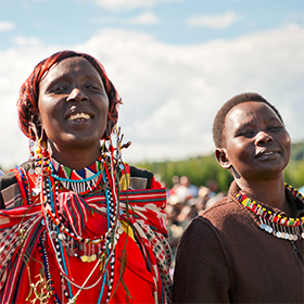
1. Land Certification in Ethiopia’s Lowland Pastoral Areas

Ethiopia-Couple-with-Land-Certificate
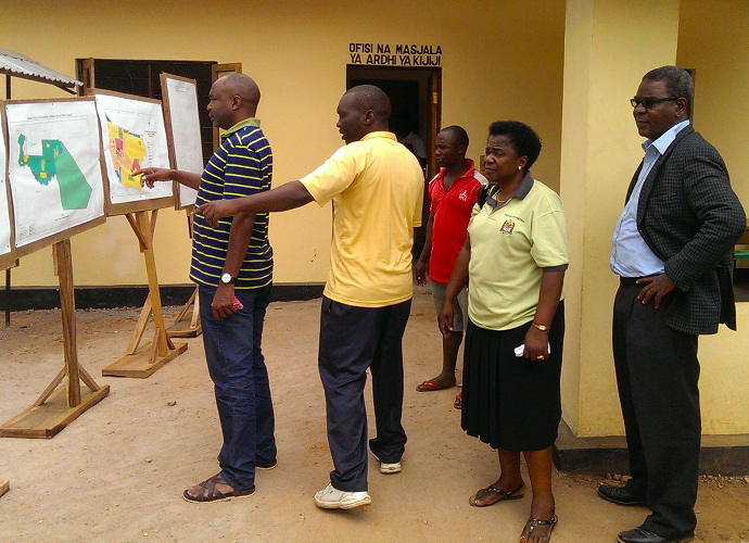
Land Certification in the Ethiopian Highlands

Since 2005, USAID has supported a series of land certification schemes that have registered and surveyed over 800,000 parcels and issued over 500,000 land use certificates. Under these programs, boundaries were clarified and validated by neighbors and community members prior to certification, which reduces the likelihood of disputes among neighbors over land. The programs also piloted a method of co-registration of spouses to strengthen women’s land rights.

Preliminary evidence from the government’s own attempts to strengthen farmers’ tenure security shows a number of positive impacts: land certification was correlated with 40-45% higher land productivity in the Tigray Region and 30% higher soil and water conservation investments in the Amhara Region. The Government of Ethiopia is now scaling up this model – using new low-cost high resolution imagery –with support from the U.K. Department for International Development, the World Bank, and the Government of Finland, among others. Meanwhile, USAID is implementing an impact evaluation to measure the livelihood and production impacts of USAID-supported land certification programs in the highland regions of Ethiopia.

Following on the initial success of certification programs in the highlands, USAID recently launched a new program to strengthen community-level land rights in the pastoral areas of Ethiopia’s lowlands. This program is piloting models to map, register, and certify customary communal land use rights, as well as strengthen customary land governance arrangements. The results of this pilot will also be rigorously assessed through an independent impact evaluation, and the success of this approach could provide lessons on how to strengthen land tenure security in pastoral areas elsewhere in the region, such as in Kenya, Tanzania, and Sudan.

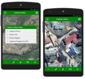
2. Mobile Technology Pilot to Document Land Rights in Tanzania

IMAG0245-cropped
Using Mobile Technology to Map Land Rights in Tanzania

In Tanzania, USAID is piloting an innovative approach to documenting land rights information using mobile technology. Land information, such as land claims and boundaries, is documented using low-cost and readily-available devices, such as GPS-enabled smart phones and tablets, coupled with crowd-sourced data collection methods. Under this program, USAID will train local community members to use technology to gather land rights information in rural and underserved settings. The resulting information will be used to quickly build a reliable database of land rights claims, which can then be verified by the government so that formal documentation can be issued in a more transparent, cost-effective, and timely manner, thus increasing land tenure security. USAID has built in an impact evaluation of this approach to help the Government of Tanzania and other stakeholders determine whether this is a viable alternative approach to more traditional and more costly land administration interventions.

3. Land Tenure and Climate-Smart Agriculture in Zambia

TGCC_QR_Cover_July-September_2014
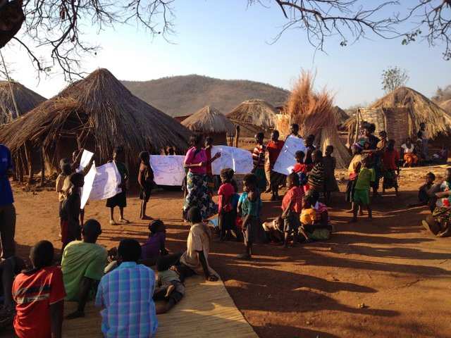
Community Land Rights Mapping in Zambia

In Zambia, USAID is strengthening smallholder farmers’ land and resource rights to increase investment in climate-smart agricultural practices, specifically agroforestry. Research shows that farmers who invest in agroforestry see positive benefits, including increased crop productivity and soil fertility, reduced variability in yields, and higher, more reliable farm income. However, agroforestry has not been widely adopted in the region, and while existing research suggests that tenure insecurity may be an important barrier to uptake, there has been insufficient evidence to date on how best to secure property rights to promote agroforestry adoption.

In selected sites in Zambia’s Eastern Province, USAID is piloting a series of interventions that strengthen smallholder rights to land and trees and provide agroforestry extension services to facilitate tree planting adoption and survivorship on smallholder farms. We are conducting a randomized control trial assessment to evaluate the impact of project interventions on the land use and livelihood decisions of smallholder farmers. With the consent of the customary authorities, villages were randomly assigned to receive either the agroforestry intervention, the land tenure intervention, both the agroforestry and land tenure interventions, or no intervention (the control group). A baseline survey has already been administered to 4,000 households in 315 villages, and an endline survey will be conducted in 2019. With this strong impact evaluation design, USAID hopes to quantify the correlation between secure land tenure and higher investments in agroforestry.

Supporting Missions Across 24 Countries

These are just three examples of promising approaches from our work in Africa. Across 24 countries, USAID’s Office of Land Tenure and Resource Management is supporting USAID missions to carry out projects, impact evaluations, and research activities that test and scale models to strengthen land tenure and property rights in support of key development objectives. To learn more, visit the following pages:

Harmonizing Land Tenure in National Protected Areas in Honduras

Guest commentary by Christopher Seeley, Chief of Party of the USAID Honduras ProParque project.

One of the most vexing challenges in biodiversity conser/project/proparque-hondurasvation in developing countries is reconciling land tenure and land use issues that emerge when previously unprotected or unregulated ecosystems are placed under state control as part of a national protected areas system.

Communities and resources that were once unencumbered by land use policies and regulations—for better or worse—are placed under a new paradigm with the stroke of a pen. New national protected area boundaries are often created with altruistic conservation objectives, but with little local stakeholder input. These boundaries define, and in many cases, constrain local household livelihood options, place restrictions on the ability of existing communities to access traditionally available and locally controlled natural resources, and legally exclude communities from social and economic development opportunities that communities outside of these “special areas” have a right to pursue.

USAID’s ProParque project in Honduras takes a different approach; it has developed a collaborative method to define boundary limits and legalize the community’s use of park land. The above video describes the project’s participatory approach and key activities, which includes:

  1. identifying weaknesses in protected area boundary delineation criteria;
  2. replacing inadequate criteria with groupings that more holistically optimized social, cultural, economic and biodiversity/natural resource management conservation parameters;
  3. forming inclusive working groups comprised of community participants, protected area managers, municipal leaders and government representatives, to analyze the land tenure and land use implications of the new boundary delineation criteria;
  4. defining community and protected area boundaries with cadastral and legal precision using the agreed upon criteria; and
  5. providing legal protection and transparency for all parties through land and usufruct titling.

The Census, Mapping and Land Regularization approach (“Censo, Medición y Regularización de Tierras” in Spanish) developed under ProParque was first piloted in Western Honduras, in the Celaque National Park. Created in 1987, during a “boom” of national park decrees, the core zone of the park (a cloud forest containing the headwaters of nine rivers) was created in the home territories of numerous indigenous Lenca communities. These communities faced a near total prohibition on resource utilization and were denied access to most government-sponsored social and economic development initiatives. The park was an ideal pilot site for the new approach given the magnitude of the affected population (several hundred households), the sensitivity of their location (deep within the core protected area), and the willingness of both the communities and local leaders to resolve the long-standing conundrum.

The pilot was completed in two phases over eighteen months, financed by the ProParque Small Grants Fund and implemented by the park’s co-management organization MAPANCE. The first phase consisted of community engagement and the creation of a comprehensive census that provided an in-depth portrait of each community’s livelihood assets and on-the-ground reality, and cadastral work at a level of detail adequate for land and usufruct title purposes. The second phase began with a secondary round of community and governmental dialogue to resolve any differences of opinion or position regarding the results of the census and land mapping work.

There have been two important results to date. First, the Government of Honduras has adopted the approach as the standard for resolving land use conflicts and boundary delineation within the national protected areas system. As part of a wider strategy for the rationalization of Honduras’ overly complex protected areas system of categorization, the approach is now being applied to five additional parks.

Second, significant impacts at the initial pilot site in Celaque National Park have been observed. Four hundred and fifty-three families in eight communities have been granted legal title to their lands and usufruct rights to related resources, the core protected area of the park has been redefined using priority conservation target criteria, and the adoption of collaboratively defined zoning for the park is paving the way for a wide variety of initiatives—including carbon- and water-based payment for environmental services agreements, public-private ecotourism partnerships, and the expanded adoption of environmentally friendly coffee certifications by smallholders.

The “Censo, Medición y Regularización de Tierras” approach adopted by ProParque addresses the natural conflict that exists between allowing communities to access natural resources and protecting biodiversity. As a result, the project aligns with USAID’s development objectives related to biodiversity and global climate change. This participatory effort, which engages with communities from the outset and actively seeks mutually beneficial solutions, provides a strong model for future programming in these important sectors.

Read more about USAID’s ProParque project.

Kenya Justice Project Pilot Ready to be Scaled-Up Nationwide


In Kenya’s Ol Pusimoru community, twenty-two women were elected as community elders in 2013, up from 14 in 2012, and zero three years ago.

In Kenya’s traditional, patriarchal Maasai society, women are gaining a new voice and increasingly, seeing their rights to land being recognized and upheld. Twenty-two women were elected as community elders in 2013, up from 14 in 2012, and zero three years ago. This transformation was made possible thanks to a USAID-supported pilot project, Enhancing Customary Justice Systems in the Mau Forest, also known as the Kenya Justice Project (KJP). KJP started during a unique window of opportunity that opened following violent post-election conflict in 2007/8. The violence led to the adoption of a new progressive constitution in 2010. This new constitution enshrines women’s equal rights to property and formalizes the role of traditional leaders as local dispute resolvers.

KJP focused on educating key stakeholder groups through legal literacy and skills trainings, peer sessions, community conversations, and public information activities to increase legal knowledge around constitutional rights and traditional leaders’ responsibilities related to land. The project also demonstrated to Kenyan and U.S. government officials that land is the number one issue of concern for rural communities. While the pilot was designed specifically for the Mau Forest, it could be adapted in other regions. To help replicate the success of the KJP model across Kenya, additional funding was allocated in 2014 for a second phase of KJP to produce a new draft implementation guide to make the model replicable.

The implementation guide outlines KJP’s underlying principles, and the steps, resources and time needed to prepare for and launch similar efforts in new communities. Although the pilot had little funding across phases—only $490,000 to date—it secured buy-in from key players in the Kenyan government, including the Deputy Chief Justice. Importantly, it implemented education and behavior change activities at a comfortable pace using trainers who were respected members of the local community. Awareness raising activities continue to be targeted toward the government and NGOs in order to promote the project and encourage a gender-sensitive approach to the integration of the formal and informal justice systems.

Education and high-level buy-in were the keys to the success of this unique pilot project. Within the community, education was targeted at all levels and groups—from traditional elders and chiefs, to youth and children, and women. Each group learned about and discussed their rights under the constitution. Traditional leaders came to see the important role they play under this new constitution: they are responsible for upholding women’s rights to land. At the same time, they came to see the important role that women play in the community and the benefits that all families could experience by securing women’s rights to land. With this different perspective, traditional leaders invited women to become elders and sit with them to decide local cases. Women and men became confident that they could claim their rights through a more impartial legal process instead of using violence or extra-judicial means. USAID’s Senior Rule of Law Advisor, Ms. Achieng Akumu observed, “People are hungry for this – they have seen the improvement in their lives and are ready for it with the constitution’s devolution of rights.”

According to KJP’s implementing partner, Landesa, “With broader implementation, the transformation that has taken place in the pilot community of Ol Pusimoru can take hold across Kenya, enhancing women’s rights and economic opportunities for all.” With additional funding for training-the-trainer activities and field tests of the model in additional rural communities, the KJP pilot can be sustainably handed off for host-country ownership and scaled across Kenya.


Honoring Anniversary of Indian Ocean Tsunami with Lessons Learned

This week in Jakarta, Indonesia, the Intergovernmental Oceanographic Commission of UNESCO (IOC-UNESCO) will hold a conference on the Indian Ocean Tsunami Warning and Mitigation System 10 years after the Indian Ocean Tsunami: Achievements, Challenges, Remaining Gaps and Policy Perspectives. This gathering provides an opportunity to discuss the policy and programming challenges related to disaster risk reduction. Weak land governance and insecure land tenure needs to be a part of this important discussion.

One of the keys to building more resilient communities – both pre-disaster and during post-disaster relief, recovery, and reconstruction – is secure land tenure and property rights. Land tenure considerations are often missing from current humanitarian response efforts, as highlighted in the USAID’s recently published Land Tenure & Disasters issue brief. The brief considers experts’ predictions that climate change will make disasters more frequent and more damaging, and recommends changes for both humanitarian response efforts and mitigation through DRR.
Some of the key recommendations include:

  • Recognize a continuum of land tenure arrangements that exist in practice prior to a disaster;
  • Document, register, survey, and protect land records to strengthen the land rights of vulnerable groups including women, youth, migrants, and the poor. This can be done through community-led enumerations/mapping;
  • Support participatory enumeration exercises to document local land tenure practices that give community members “secure enough” tenure. Involve community groups in decisions about designating areas as unsuitable for habitation;
  • To address land claims, consult with the community, relevant customary authorities, and formal land administration agencies and, as needed, support accessible dispute resolution mechanisms;
  • Be aware of to power relations within communities and between communities and government agencies; and
  • Strengthen the technical and managerial capacity of institutions that govern land use and property rights through disaster risk reduction efforts.

For detailed guidance, the issue brief lists existing manuals that show how to address land tenure and property rights challenges in both disaster risk reduction interventions and in post-disaster relief, recovery, and reconstruction.

Download the Land Tenure & Disasters issue brief.

Burma Draft National Land Use Policy Open for Public Consultations

Guest commentary by Robert Oberndorf, Resource Law Specialist, Tenure and Global Climate Change Project.

Since December of 2013, USAID’s Tenure and Global Climate Change Program has been providing technical assistance to the Government of Burma to develop a draft National Land Use Policy. The policy is intended to address many of the difficulties faced in reforming the governance frameworks related to democratic resource administration and strengthening land tenure security in the country. The policy is also intended to guide the development of a comprehensive umbrella land law for the country, which will help to address some of the challenging legal harmonization issues confronting the country. While improving land use administration and governance in Burma is a complex endeavor, there are promising signs that progress is being made. The development of the draft policy is one such sign.

The Government of Burma has been developing the draft policy using a multi-stakeholder consultation process that began in 2012 with the National Dialogue on Land Tenure and Land Use Rights. The findings from this event fed directly into the draft policy. In addition, advice from non-government technical experts (national and international); extensive research on various land use issues in Burma from academic institutions, donors, INGOs and CSOs; information from media reports; and findings from various Parliamentary commissions on land use issues have fed into the development of the draft National Land Use Policy.

The draft policy, while attempting to balance the interests of multiple stakeholders, emphasizes strengthening the land tenure security of smallholder farmers, ethnic communities, women, and other vulnerable groups in Burma. The policy also includes important provisions on

  • ensuring the use of effective environmental and social safeguard mechanisms,
  • improving public participation in decision-making processes related to land use planning,
  • improving public access to accurate information related to land use management, and
  • developing independent dispute resolution mechanisms.

The draft policy also includes guidance aimed at strengthening the government’s mechanisms for handling land acquisition, compensation, relocation, and restitution.

Considering the fact that Burma has never had a land use policy before, the development of this draft policy is unprecedented on many levels. For example, the Government of Burma has opened the draft policy to a process of public comment and consultation. On October 18, 2014, the Government of Burma held a multi-stakeholder meeting in Yangon to publicly release the draft National Land Use Policy and officially begin a process of nationwide public consultations. The government provided a dedicated e-mail address to send comments. A process for conducting public consultations in every region and state of the country during the month of November was also announced. Once all comments are submitted, they will be assessed for relevance, categorized, and incorporated into the policy through an approach that attempts to balance the views of various stakeholders. A final national workshop will be held to present the revised version of the draft policy prior to final consideration by the Union Government and formal adoption.

To date, reaction to the draft policy has been mixed, with a major concern that the public consultation process does not provide enough time for civil society organizations and the public to fully review and meaningfully comment on the draft. In response to this, the Government initially moved the schedule for the public consultations back one week. It is not clear whether the schedule for consultations might be adjusted further to address the concerns raised by various civil society organizations in the country.

While the public comment and consultation process led by the Government of Burma may be less than perfect, it is nonetheless a watershed moment for Burma that presents a unique opportunity for all stakeholders to make recommendations on an area of policy that directly impacts such a large portion of society in Burma.

Learn more about land tenure and property rights issues in Burma.