
Overview
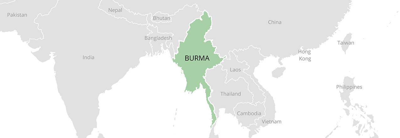
Burma is situated in Southeastern Asia, bordering Bangladesh, India, China, Laos and Thailand. The majority of its population lives in rural areas and depends on land as a primary means of livelihood.
Because all land in Burma ultimately belongs to the state, citizens and organizations depend upon use-rights, but do not own land.
Burma’s laws grant women equal rights in some respects and also recognize certain customary laws that provide women equal rights in relation to land. In practice, however, the rights of many women are governed by customs that do not afford them equal access to or control over land.
Forcible and uncompensated land confiscation is a source of conflict and abuse in Burma, and protests and fear of “land grabs” have escalated as the state opens its markets to foreign investors and pursues policies to dramatically increase industrial agricultural production.
Burma has rich water, forest and mineral resources. However, a rapid expansion of resource extraction efforts in the past three decades has led to widespread land and water pollution, deforestation, community protests and forced relocation.
Key Issues and Intervention Constraints
To help strengthen the implementation and reform of existing law and build corresponding institutional capacity, USAID and other donors might consider focusing on the following high-impact interventions:
The body of law governing land in Burma is expansive, complex and poorly harmonized, with many of the legal instruments still dating back to the late nineteenth century. Although the state enacted several major land-related laws in 2012, their effect on preexisting laws is unclear. In addition, Burma has adopted a National Land Use Policy (NLUP) covering land use, land tenure and land administration; it is also developing additional policies to meet land-related needs in sectors such as agriculture. Donors should provide well-coordinated technical, legal and other support for the development and implementation of strategically prioritized and sequenced issue specific policies, laws and implementing regulations required to improve land governance, implement the NLUP and eliminate inconsistencies with existing laws and rules.
The new government faces a huge backlog of land-related disputes and grievances, many going back decades. The Government created a Farmlands and Other Lands Acquisition Reexamination Central Committee, along with related subsidiary committees, to address land confiscation and the dispossession of smallholder farmers. Such an effort aligns with the NLUP, which seeks to develop equitable, accessible and transparent mechanisms to resolve such disputes. Donors should provide support to these Committees and other alternative land dispute resolution mechanisms to build capacity and enhance transparency in support of stronger land governance, while simultaneously addressing land tenure issues relating to internally displaced persons and returning refugees in a holistic manner.
Populations relying upon customary tenure arrangements, which the government does not yet legally recognize, as well as smallholder farmers whose land use does not align with how land has been classified or who did not report their land use to the government in the past, are vulnerable to being removed from their land without receiving compensation. Donors should improve tenure security for these populations by supporting the development of: laws and policies that are consistent with the new NLUP and recognize and respect customary tenure systems; and registration schemes that allow for the titling of land under rotational fallow or other customary tenure arrangements.
The land rights held by women in Burma are often highly insecure. Cultural norms and practices often marginalize women within their marriages and households, and many women lack awareness of their rights as joint owners of family land or as family members with rights of inheritance. Rights held by women-headed households are particularly vulnerable to loss to male family members, local elites, and commercial interests. Donors should work with the government to protect and improve women’s land rights through educational programs and legal literacy campaigns focused on increasing women’s knowledge of land rights and land administration procedures. They could also provide support for programs that assist women, their families, and their communities with training in communication and dispute-resolution techniques. Additionally, donors could support the development of legal aid organizations and NGOs, as well as their efforts to expand their services to include a focus on protecting and improving women’s land rights.
Landlessness rates are significant nationally and especially in the Ayeyarwaddy Delta and the Bago Region. Estimates of landlessness among Burma’s rural population range from 30 percent to 50 percent depending on the source of the estimate and the definition of “landless.” Donors should help reduce landlessness by supporting the analysis and development of laws and policies to reduce landlessness and an investigation of whether and in what regions land might be available for allocation to households that possess less than an acre of land.
Burma’s laws permit the state to use compulsory acquisition to acquire land for public purposes and for business purposes. The law defines neither purpose in detail, leaving landholders vulnerable to losing their land through arbitrary processes. Donors should help improve compulsory acquisition processes by providing technical, legal, and policy support for the development of clear procedures and authority that embodies minimum international standards for fair and effective compulsory acquisition procedures consistent with the NLUP.
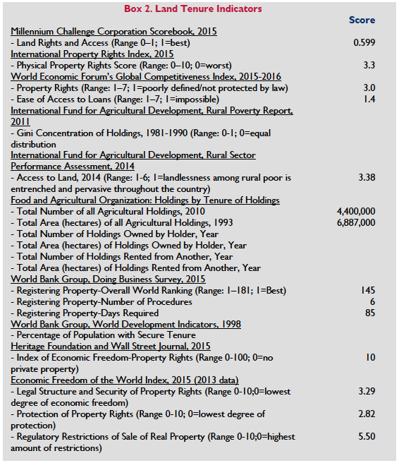
For land registration Burma relies on an antiquated deed registration system, where registration of land involves multiple ministries and can take 6-8 months to perfect title. It also lacks a comprehensive and accessible land information management system. Donors should continue to support the OneMap Initiative on land information as well as development of a new, more effective land title registration system.
Community forestry initiatives have strengthened the land rights of villagers, ensuring greater protection from land expropriation, as well as increased village participation in land governance. However, community forest groups have been both slow to expand and in some cases – as a result of their neglect of balanced agroforestry strategies, local needs, gender dynamics and marginalized groups – have adversely affected food security in villages. Donors should support the expansion of community forest user groups that encourage sustainable, equitable and participatory strategies in forest management and a review of the Forestry Law to determine how it could be revised to better facilitate community forestry.
Freshwater resources in Burma are abundant, but access to water is temporally and spatially uneven. Water quality has rapidly deteriorated as a result of urbanization, industrialization, and mining activities, along with a lack of adequate sanitation facilities. Insufficient data, as well as vague legislation and overlapping institutional authority, have hampered water management. Donors should help reduce water pollution by facilitating investment in sanitation facilities in both urban and rural settings. Donors could also offer technical assistance to help the government obtain better data on water resources and improve coordination of water management across agencies. Moreover, donors could continue to improve government capacity for sustainable hydropower planning to identify and prioritize the projects with the highest impact for development and poverty reduction. Finally, donors could provide continued support for the development of a National Water Law consistent with the National Water Policy.
Historically, Burma has lacked the necessary laws, regulations and enforcement mechanisms to protect its environment and vulnerable populations against the impacts of mining. Over the past two decades, these inadequacies have led to conflict and widespread environmental degradation in the wake of a rapid increase in large-scale mining. As investment in the country’s mineral sector increases, conflict between mining interests and local communities will likely increase. The effect of the newly-adopted amendments to the 1994 Mining Law has yet to be determined. Donors should help the government manage competing interests by supporting an analysis of the new Mining Law to determine how it might be improved so as to support investment while recognizing the rights of local communities. Donors could also help local communities protect their rights and interests through public-awareness building, community organizing and the development of contracting and negotiation skills. Specific attention should be given to developing a foundation for the negotiation of fair and equitable benefit-sharing agreements, with mechanisms to ensure that benefits reach all members of local communities. Finally, donors could provide continued support for Burma’s participation in the Extractive Industries Transparency Initiative.
Summary
Approximately 66 percent of Burma’s population lives in rural areas, and the majority depends on agricultural land as a primary means of livelihood. Burma is the poorest country in Southeast Asia, and poverty rates are particularly high in rural areas, where it is estimated that 30–50 percent of households are landless, and in border regions populated by minority ethnic groups.
 Burma’s Constitution dictates that all land ultimately belongs to the state. The body of law governing land is expansive, complex and poorly harmonized, and dates back to the British colonial period. In 2012, the state enacted several high-profile laws whose effect on preexisting laws and systems is not yet clear. These include the Farmland Law and the Vacant, Fallow and Virgin Lands Management Law (VFV Law). Burma adopted a new National Land Use Policy (NLUP) in early 2016 which will necessitate substantial revisions to the legal framework governing land tenure and administration.
Burma’s constitution guarantees women equal rights before the law, and the government claims that women have equal rights to administer property. Customary laws, which govern succession, marriage and inheritance, grant Buddhist women (the majority of women in Burma) equal rights in property matters. These customary laws and Burma’s statutory laws do not always govern in practice, however, and many women are subject to systems that do not afford them equal rights. Furthermore, Burma’s newest laws governing land (the Farmland Law and VFV Law) are not gender neutral and appear to lack a mechanism for the joint ownership of property between husbands and wives.
The primary central bodies governing land in Burma are: the Ministry of Agriculture, Livestock and Irrigation (MoALI), whose departments are responsible for land-use planning, water resources, irrigation, mechanization, land management and administration, among other matters, concerning farmland; the General Administration Department (GAD) with the Ministry of Home Affairs, which has management authority over virgin, fallow and vacant lands; and the Ministry of Natural Resources and Environmental Conservation (MoNREC), which has authority over the Permanent Forest Estate and mining lands. The Farmland Management Body (FMB) and the Central Committee for the Management of Vacant, Fallow and Virgin Lands (CCVFV), both established by laws enacted in 2012 and chaired by the head of MoALI, are responsible along with their lower-level branches for approving certain requests for land-use rights.
Burma’s land market has grown in the past two decades and has produced a particularly dramatic increase in the number of commercial landholdings. Prices have climbed in both urban and rural areas, due in part to land speculation. While there is some concern that inflated, prices will deter foreign investment in Burma’s land market, there is also alarm over prospects that increased foreign investment could lead to an epidemic of land confiscations. The law allows the state to use compulsory acquisition to acquire land for public purposes and for business purposes, neither of which the law defines in detail. Although Burma’s laws require the state to pay compensation for land it acquires, in practice the compensation often falls short of minimum standards or does not occur at all. The NLUP commits the government to adopting international best practices and observing human rights standards in its activities related to land acquisition, relocation, compensation, rehabilitation and restitution.
Natural resources are a leading source of conflict, and development projects have often involved Burma’s military forces, which have a history of displacing and violently abusing affected populations. Conflict and abuse have also surrounded the military’s confiscation of land in cases unrelated to development projects. Of particular concern in recent years is the forceful and uncompensated confiscation of land for urban expansion and for commercial, industrial and infrastructure projects. There have also been instances of forced confiscation of land resources by other groups in areas not under the control of the Union Government. As the state pursues an ambitious plan to convert vast amounts of land to industrial agricultural production, farmers are increasingly protesting what they call “land grabs.”
Burma has diverse natural forests, including tropical evergreen forests, hill forests and temperate evergreen forests. Forests cover approximately 48 percent of Burma’s land area. Deforestation due to excessive legal and illegal logging as well as traditional practices has emerged as a significant problem for Burma, with the country losing an average of 546,000 hectares of forest annually since 2010, the world’s third worst rate of deforestation.
Rapid exploitation of Burma’s natural resources is threatening the country’s agricultural and forest land. Large dam building, oil and gas extraction, mining, logging and large-scale agriculture projects are leading to severe soil and water degradation, as well as the forced displacement of smallholder farmers and minority ethnic communities.
Land
LAND USE
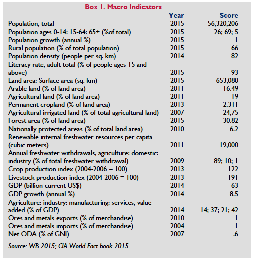
Burma is located on the Andaman Sea and the Bay of Bengal and shares borders with Bangladesh, India, China, Laos and Thailand. It is the largest country in mainland Southeast Asia and has a land area of 653,508 square kilometers, of which 124,400 (roughly 19 percent) are agricultural (CIA 2015; World Bank 2015).
The country’s estimated 2014 GDP was $63.14 billion, with 42 percent attributed to services, 37 percent to agriculture and 21 percent to industry. Key exports include natural gas, wood products, pulses, beans, fish, rice, clothing, jade and gems. Primary agricultural products include rice, pulses, beans, sesame, groundnuts, sugarcane, fish and fish products and hardwood (CIA 2015).
The population of Burma is 56,320,206 with an annual growth rate of about 1 percent. Access to agricultural land is the most important resource for rural households. 66 percent of the population is rural. Fully 65-70 percent of the population is believed to be involved in agriculture, with women making up 49 percent of the agricultural labor force (World Bank 2015; CIA 2015; ADB 2011; FAO 2015).
Burma is the poorest country in Southeast Asia. Roughly 26 percent of the population lives below the poverty line (calculated as minimum necessary caloric and non-food expenditures), though that rate is slowly declining. (A different measure of poverty used by the World Bank finds a higher poverty rate of 37.5 percent.) The rural poverty rate is 29 percent, roughly twice the 15 percent poverty rate in urban areas (39 percent and 29 percent, respectively, using the World Bank analysis). Rural areas account for nearly 76 percent of Burma’s total poverty, and four states contribute the most to the national incidence: Ayeryawaddy (19 percent), Mandalay (15 percent), Rakhine (12 percent) and Shan (11 percent). Proportionally, the following states have the highest rates of poverty among their populations: Chin (73 percent), Rakhine (44 percent), Tanintharyi (33 percent), Shan (33 percent) and Irrawaddy (32 percent) (IHLCA 2011; UNDP 2014; WB 2014; WB 2015a).
 Approximately 17 percent of Burma’s land is arable, 2 percent is permanent cropland, 0.47 percent is meadow and pastureland, and 48 percent is forestland. Approximately 25 percent of Burma’s agricultural land is irrigated (FAO 2011a; World Bank 2015; CIA 2015). Burma’s physical geography varies across its regions, which are divided into the Uplands, the Dry Zone and the Irrawaddy Delta. The Uplands contain hilly terrain that ranges from 1000 to 2000 meters in altitude, and stretch along the eastern, northern and western states of Kachin, Kayah, Kayin, Mon and Tanintharyi and Chin, as well as parts of Shan, Mon and Rakhine.
Traditional shifting “swidden” agriculture is common in these areas. However, growing population density is forcing farmers to clear increasingly steep hills, where poor soil quality does not support sustained cultivation or allow for appropriate fallow periods. Many farmers in Shan and Kachin states have preferred to plant opium, a cash crop that they can harvest quickly and use to secure advance credit, rather than rice, which is easily looted and taxed by nearby combatants. Some farmers in the Uplands flat valley areas grow rain-fed paddy rice as well as corn, millet, ginger and coffee (COHRE 2007; WB 2014; Raitzer et al 2015; Woods 2015).
The country’s Dry Zone is a central heartland area that spans Burma’s semiarid region. Most farmers in this area are commercial farmers growing cash crops such as sesame, pulses and beans for export. Onions, potatoes, tomatoes and other seasonal vegetables are often grown on alluvial soils, and cotton is a common crop in the Dry Zone’s northern area. It is estimated that 7–10 acres of average land (or 15–20 acres of poor quality land) are required to sustain minimum standards of living for a family in this area. During slack seasons, many farmers migrate to Rangoon, Mandalay and border areas to find work. In addition to seasonal unemployment, people in the Dry Zone’s rural areas face frequent droughts and increasing land degradation in the form of loss of natural vegetation, soil erosion and deterioration of soil fertility (COHRE 2007; Kyaw and Routray 2006; Raitzer et al 2015; UOB 2005; IFAD 2013).
About 60 percent of Burma’s cultivated area is devoted to rice, which accounts for 43 percent of national agricultural commodity production value. Rice yields, as well as yields for other crops, tend to be lower than in other Asian countries and far below their potential; they are the second lowest in Asia. The Irrawaddy Delta area has been at the center of the rice economy since the British colonial period. In the Irrawaddy Delta, monsoon paddy cultivation is the most important income source for 25 percent of households. In households where rice cultivation is not the primary economic activity, members nonetheless practice small-scale or casual cultivation as a secondary source of income. Rice farmers sell about 75 percent of their crop at market, consume about 20 percent and reserve 5 percent for the next season’s seeds. Burma is a net exporter of rice and is estimated to have exported 324,000 metric tons in 2013, a significant decline from the previous year. (Pulses and beans are the largest export crops.) Many marginal farmers in the Irrawaddy Delta also engage in fishing or crabbing, but most do not own their own gear or boats and depend on traders for equipment. The region’s environment is deteriorating rapidly, and sources of fresh water, crabs, firewood and vegetables are scarce (WB 2014; Raitzer et al 2015; COHRE 2007; LIFT 2011; Suwannakij 2012; WB 2015a).
Burma has an exceptional level of biological diversity and is home to Asia’s most extensive intact tropical forest ecosystems. These include delta mangroves, lowland tropical rainforests, teak forests (including the world’s only remaining golden teak forests), semi-deciduous forests in the north, and sub-alpine forests in northern Kachin State. Widespread forest loss and degradation due to logging, hunting, mining and other extractive industrial activities has become a serious problem, threatening ecosystems and leading to floods, soil erosion and landslides, which result in sedimentation build-up behind dams and river siltation, ultimately reducing the amount of available surface water. Erosion washes away nutrient-rich topsoil, reducing the land’s fertility, which, when combined with the reduced availability of water, stunts agricultural productivity (BEWG 2011; IRIN 2011).
Burma’s five main rivers are the Irrawaddy, Chindwin, Salween, Sittaung and Tenasserim. Some of these contain endangered species. Each of these rivers has piqued investor interest in their hydropower and irrigation potential. Livelihoods in rural Burma depend heavily on rivers and streams, many of which are under threat from development of large dams that could result in submersion of agricultural and forest land and the forced relocation of local communities (BEWG 2011; International Rivers Watch 2014).
Government promotion of large-scale monoculture plantations increased since 2008 under the presidency of Thein Sein, though it appears the newly elected Government led by the National League for Democracy is placing greater emphasis on smallholder farmers, crop diversification and land tenure security in accordance with the new Agriculture Policy (2016) and draft Agriculture Development Strategy. These plantations, some of which are threatening ecological integrity, food security and the livelihoods of local farmers, typically grow annual crops such as cassava, sugar cane and paddy rice, and industrial crops such as palm oil and rubber (BEWG 2011; Woods 2015a; MoALI 2016).
LAND DISTRIBUTION
Roughly 66 percent of Burma’s population lives in rural areas. The great majority of this population is poor and depends on land-based resources as a primary means of livelihood (CIA 2015; FAO 2015).
Burma’s government has reported that the country has 8 major ethnic groups and 135 sub-ethnic groups. Ethnic Burmans constitute around two-thirds of the population. Together, Burma’s ethnic minorities constitute about 35 percent of the total population. The largest minority groups are the Shan (9 percent) and the Karen (7 percent), while the remaining groups – which include the Mon, Rakhine, Chin, Kachin, Karenni, Kayan, Chinese, Indian, Danu, Akha, Kokang, Lahu, Naga, Palaung, Pao, Rohyinga, Tavoyan, and Wa groups – each constitute 5 percent or less of the population (IFAD 2013; MRGI 2007; COHRE 2007).
Most of Burma’s minority ethnic groups live in the country’s border regions, where poverty is most acute. These same areas hold most of Burma’s valuable natural resources, are most affected by the country’s decades-long civil war and account for the greatest share of small and marginal landholdings. Less than 5 percent of the households in eastern Shan State have farms larger than 5 acres. In Kachin State and Chin State, only 25–28 percent of households have farms larger than 5 acres (Ash Center 2011; Hudson-Rodd 2004; MRGI 2007; BEWG 2011; FAO 2014).
Burma’s average farm size (6 acres) is moderate by Southeast Asian standards and low by international standards. Farm size does, however, vary considerably across states, with the largest average sizes found in Irrawaddy (11.2 acres) and Yangon (9.3 acres) and the smallest in Chin State (1.7 acres). In the Dry Zone, farms average 4.5 acres, compared to 10 acres in the coastal and delta areas and 2 acres in hilly areas. About one-third of all farmers have farms of one hectare or less (IFAD 2013; IHLCA 2011; FAO 2014; WB 2015a).
Estimates of landlessness among Burma’s rural population range from 30 percent to 53 percent depending on the source of the estimate and how “landless” is defined. Under any definition, poverty in Burma is closely associated with landlessness or functional landlessness (holdings of less than 2 acres), especially in the Delta, Coastal and Dry zones, however, the incidence of landlessness varies by region. One study, which defined landlessness as having no land use rights to cultivable land, found that the proportion of landless households is highest in the Ayeyarwaddy region in lower Burma followed by the Dry Zone in central and western Burma. That study reported that other heavily affected areas include Kachin and Mon States. Increasing numbers of people have been displaced from their land in Shan, Tanintharyi, Rakhine and Chin States as Burma’s military has established bases in these areas (IFAD 2013; MSU and MDRICESD 2013; World Bank 2014; Reuters 2012; COHRE 2007; Hudson-Rodd 2004).
Evolving dynamics in the agricultural sector are changing the distribution of land in Burma. Government allocation of land resources to commercial agriculture companies is on the rise, but is unfolding differently across the country. In general, the government is able to grant leases of lands at the disposal of the state in areas under its political control, which include the central Dry Zone, Yangon Region and Ayeyarawaddy Region.
As mentioned above, the previous government promoted the establishment of large-scale monoculture plantations. The previous government’s Master Plan for the Agriculture Sector (2000-2030) called for 10 million acres of new private agriculture plantations. MoALI’s new Agriculture Policy, released in December of 2016, places far greater emphasis on supporting smallholder farmers, crop diversification and land tenure security. At the same time, acreage for rubber, Burma’s most widely planted industrial crop, more than tripled from 2004 to 2014. While most rubber production is in southern Burma, especially in Mon State, major expansions of large-scale rubber plantations have taken place in Kachin State, northern Shan State and the Wa autonomous region, often to the detriment of small-scale upland farmers who are displaced from their land, often without compensation. (BEWG 2011; Woods 2011; UOB 2014 (Min. of Ag); MCRB 2015; Global Witness 2015; MoALI 2016).
Oil palm plantations, for which companies burn and clear-cut land, are centered in Tanintharyi Region in southern Burma. Businessmen from Burma own the majority of oil palm plantations, while the military and smallholder farmers cultivate a very small percentage (UOB 2014 (Min. of Ag) BEWG 2011; Woods 2011).
LEGAL FRAMEWORK
Burma’s current legal framework is the product of several distinct periods in the country’s history, including the British colonial period (1886–1948), post-colonial independence (1948–1962) and decades of rule by a military junta (1962- 2011) and post-junta rule, including the election in 2016 of the democratically elected government of Htin Kyaw (2011-present). Because many of the laws from these periods are still in effect, the body of law governing land in Burma is expansive, complex, and characterized by vague, conflicting and overlapping provisions. Laws affecting land in Burma are also poorly harmonized, as legislation is typically sector-specific and does not cross-reference or take into account other relevant and preexisting acts. One survey of the legal framework found that in 2009 at least 73 active laws, amendments, orders and regulations had a direct or indirect bearing on housing, land and property rights. Although the government repealed a number of statutes in 2012, ambiguity and confusion in the land laws remain. The government engaged in a lengthy multi-stakeholder process to adopt a new National Land Use Policy (NLUP) that is intended to provide a foundation for future land governance reforms in the country, including the harmonization of the confusing array of often antiquated laws relating to land tenure security. The public consultation process used for developing the NLUP provides a model for other policy and law development in the country. (Displacement Solutions 2012; Leckie and Simperingham 2009; Mark 2015; Srinivas and Hlaing 2015, Oberndorf, et. al. 2017).
Burma’s constitution was adopted in 2008 and came into force in 2010. While it requires all other laws, rules, regulations and policies to comply with its provisions, it also established a republic in which states, regions, divisions and zones have authority to enact their own laws so long as they do not conflict directly with the constitution or national laws, rules and regulations (UOB Constitution 2008a).
The constitution contains numerous provisions relating to land. It reconfirms that the government owns all land, stating that “the Union is the ultimate owner of all lands and all natural resources above and below the ground, above and beneath the water and in the atmosphere in the Union.” It grants citizens the right to settle and reside anywhere in the country, establishes the right of private property and inheritance, and provides that the state shall protect lawfully acquired moveable and immovable property as well as the privacy and security of home and property (UOB Constitution 2008a, Art. 37).
After several parliamentary votes and months of debates and consultations, the parliament adopted the Farmland Law in March 2012. The law defines rights and responsibilities relating to tenure and establishes a hierarchy of management over farmlands (Displacement Solutions 2012; Displacement Solutions 2015).
The Farmland Law affirms that the state is the ultimate owner of all land and creates a private-use right that includes the right to sell, exchange, inherit, donate, lease and “pawn” farmland. It also establishes a system of registered land-use certificates (LUCs) (further discussed below). This law provides that Farmland Management Bodies are to issue LUCs to farmers and that Land Records Departments are responsible for registering land rights and collecting related fees. The law: does not describe the process farmers should use to apply for LUCs and register their rights; provides only a very basic description of the government entities involved in the process; and leaves the details of implementation for the executive branch of government to define. Nevertheless, as of March 2016, about 8 million LUCs are reported to have been issued since the necessary rules, guidelines and forms were put into place in 2013 despite ongoing capacity and implementation challenges. The MOAI has also issued rules for the implementation of the Farmland Law (Oberndorf 2012; UOB Farmland Law 2012b; UOB 2012; Srinivas and Hlaing 2015; Allaverdian 2016).
The Farmland Law (2012) repealed and replaced the Land Nationalization Act (1953), the Disposal of Tenancies Law (1963) and the Agriculturalists’ Rights Protection Law (1963). It also covers: conditions under which farmers can retain farmland use-rights; the state’s power to rescind such rights; the process for settling certain land-related disputes; and basic requirements for compensation in the case the government acquires the farmland for public purposes (Htun 2012; UOB Farmland Law 2012b).
The Foreign Investment Law of 2012, as amended in 2015, governed foreign investment in land-related projects. It created the Myanmar Investment Commission, which is charged with examining and accepting certain investment proposals, issuing permits and suspending the permits of investors who fail to abide by the law’s provisions. The law granted substantial tax relief to foreign investors, including a five-year tax holiday for businesses involved in the production of goods or services, or in business deemed by the Commission to be beneficial to the Union. The law also provided significantly greater authority to the regional and state governments to receive and approve foreign investments. A new consolidated Investment Law, which merged the Foreign Investment Law and the domestic Investment Law into one, was enacted in October of 2016. (UOB Environmental Conservation Law 2012a; Oberndorf 2013; Mayer Brown 2012; Min of Planning and Econ 2013; UOB 2013; Stephenson Harwood 2016; Myanmar Business Today 2016; UOB 2016).
The Vacant, Fallow and Virgin Lands Management Law of 2012 (VFV Law) governs the allocation and use of virgin land (i.e., land that has never before been cultivated) and vacant or fallow land (which the law characterizes as for any reason “abandoned” by a tenant). As described further below, the law establishes the Central Committee for the Management of Vacant, Fallow and Virgin Lands (CCVFV), which is responsible for granting and rescinding use rights for such lands, increasingly through state and regional level bodies established by the VFV Law. The General Administration Department of the Ministry of Home Affairs plays a significant role in VFV land administration as it is often responsible for processing the required application forms. The VFV Law also lays out: the purposes for which the committee may grant use-rights; conditions that land users must observe to maintain their use rights; and restrictions relating to duration and size of holdings (Htun 2012; Oberndorf 2012; Belton, et al, 2015).
The Land Acquisition Act of 1894 (further discussed below) provides the basis for the state to acquire land for public and other purposes. Its provisions address: required notice; procedures for objecting to acquisition; land valuation methods; the process for taking possession of land; the process for appeals; and rules for the temporary occupation of land (UOB Land Acquisition Act 1894; Displacement Solutions 2012; Srinivas and Hlaing 2015).
There are potentially dozens of other laws that relate directly or indirectly to land management, land use and land as property in Burma. Chief among these are: the 1882 Transfer of Property Act, which governs the sale, mortgage, lease, exchange and gift of moveable and immovable property; the 1879 Land and Revenue Act, which governs assessment and collection of land taxes; the 1899 Lower Myanmar Town and Village Act, which governs the land rights in towns and villages and provides for certain rights (such as the right to cultivate and right to sell) relating to hereditary and government lands; the 1893 Partition Act, which governs partition of immovable property; and, the 1909 Registration Act, which governs the registration of dwellings and instruments of immovable property. Although an analysis conducted in 2009 found these laws to be still in place, it is not entirely certain that this is still the case (Leckie and Simperingham 2009; Displacement Solutions 2012; Mark 2015).
For certain matters in Burma, customary laws apply with the force of formal law. According to the 1898 Burma Laws Act, which appears to be still in effect, Buddhist, Muslim and Hindu customary laws govern matters of succession, inheritance and marriage for their respective adherents. The Buddhist Women’s Special Marriage and Succession Act of 1954 codifies some Buddhist customary law on these issues as well. For Christians, rules of succession, inheritance and marriage are governed by the Christian Marriage Act, the Burma Divorce Act (which applies only to Christians) and the Succession Act of 1925 (Sen 2001; Leckie and Simperingham 2009; Gutter 2001).
Although the law recognizes customary practices regarding succession, inheritance and marriage, the laws of Burma do not recognize the authority of other customary land-use practices. Earlier, the British had recognized the authority of a few such practices for certain Upland areas in northern and western Burma. For example, the Kachin Hills Manual respected the customary authority of Kachin headmen to rule on land uses within the community, and the Chin Hills Regulation of 1896 and the Chin Special Division (Extension of Laws) Act of 1948 recognized the Chin’s customs. Today, however, Burma’s statutory laws do not recognize customary land-use practices (BEWG 2011; Transnational Institute 2015; MCRB 2015).
The NLUP was adopted in early 2016 following a lengthy, multi-stakeholder process. It has several objectives including: promoting sustainable land use, natural resource and environmental management; strengthening land tenure and food security for all citizens; recognizing and protecting customary tenure rights; developing fair and accessible dispute resolution mechanisms; promoting inclusive decision-making, responsible investment in land and natural resources and effective land administration, Strategic development of a new legal and regulatory framework relating to land governance in the country will help to accomplish these objectives. The development, over time, of a new legal framework is likely to bring about important changes to many, if not all, of the laws described above and throughout much of this profile (National Land Use Policy 2016).
TENURE TYPES
The state is the ultimate owner of all land in Burma. All private tenure rights are somewhat limited. Tenure rights vary depending on the type of land involved, as reviewed below. There is a right to sell, lease, inherit or mortgage the rights to most categories of land, subject to the state’s underlying ownership (UOB Constitution 2008a).
Between 1850 and 1988, Burma adopted a multitude of laws that combined to create a complex assortment of land classifications. The extent to which the land classifications may have been simplified as the result of the enactment of several new laws in 2012 is unclear. At least 12 categories, some of which have changed, existed as of 2009: freehold land, grant land, agricultural land, garden land, grazing land, cultivable land, fallow land and waste land, forest land (discussed later in this profile), town land, village land, cantonment land and monastery land (UN-Habitat n.d.).
Freehold land. Freehold land equates roughly to ‘ancestral land,’ existing mostly in urban areas and rarely in small towns and villages. Freehold land is transferrable, not subject to land revenue taxes and can be taken by the state only pursuant to laws on compulsory acquisition (UN-Habitat n.d.; Leckie and Simperingham 2009; Displacement Solutions 2012).
Grant land. Owned and allocated by the state, grant land is common in cities and towns, but rare in village areas. The state may lease grant land out for extendable periods of ten, thirty, or ninety years. Grant land is transferable, is subject to land tax and may be reacquired by the state during a lease period in accordance with laws governing compulsory acquisition (UN-Habitat n.d.; Displacement Solutions 2012).
Farmland. Farmland, as defined in the Farmland Law (2012), appears to have replaced the ‘agricultural land’ classification, and includes: garden land; paddy lands; dry land (ya); alluvial land (kiang); perennial plant land; coastal land (dhani); hillside cultivation land (taungya); alluvial lands; and land for growing vegetables and flowers (UOB Farmland Law 2012b; Oberndorf 2012; UN-Habitat n.d.).
With the enactment of the Farmland Law (2012), those seeking rights to farmland must obtain permission and a land-use certificate (LUC) from the state. Farmland is transferable through sale, lease, inheritance and donation, with the condition that transfers must be registered with the state. Farmland rights may also be “mortgaged” as security for a loan, with the condition that the loan can only be used to finance agricultural production. Unless the user obtains express permission for other uses, land held under a farmland use right must be used for permitted purposes (i.e., for agricultural purposes and for “regular” crops, which the law does not define). The user cannot allow the farmland to remain fallow without sound reason and cannot transfer the use right to a foreigner or an organization that includes a foreigner without state permission (UOB Farmland Law 2012b, Arts. 12–14).
Grazing land. The Upper Burma Land Revenue Regulations of 1889 established the classification of grazing land, which the 2012 Vacant, Fallow and Virgin Lands Management Law (VFV Law) now includes within the definition of virgin land. In the past – and possibly still – grazing land was for use by cattle of nearby villagers, was protected from trespassers and was not subject to land taxes (Oberndorf 2012; UOB Foreign Investment Law 2012c; UN Habitat n.d.).
Town land. In most cases, town land is the same as freehold land or grant land. An exception, however, is when it refers to La Na 39 land, a category named for its authorization under article 39 of the 1953 Land Nationalization Act. Usually, La Na 39 land is farmland (previously known as agricultural land) that has been re-categorized for another purpose (e.g., for building houses or digging fish ponds). La Na 39 land is transferable, and those who have it registered under their name must pay land tax to the government. Because the Farmland Law repealed the Land Nationalization Act, it is unclear whether the La Na 39 category still exists (UN Habitat n.d.; Displacement Solutions 2012).
Village land. Village land is land located outside the parameters of town land and can either be grant land or La Na 39 land. Village land is transferable, but only if it has been transformed into La Na 39 land or grant land. Those with village land must pay land tax to the government unless their plot is less than one-fourth of an acre and occupied by a building (UN-Habitat n.d.; Displacement Solutions 2012).
Cantonment land. Cantonment land is land that the state has acquired for the military’s exclusive use. When an area is earmarked as cantonment land, the government issues a declaration of the designation, and the state acquires it under the Land Acquisition Act, which provides that owners should be compensated if the land was classified as freehold land, grant land or La Na 39 land. Although in the past the government was not required in this circumstance to invoke the Land Acquisition Act or to provide compensation for other types of land (e.g., agricultural land, now farmland), under the Farmland Law it must do so. The military is required to surrender cantonment land to the government once it is no longer necessary for military use (UN-Habitat n.d.; Displacement Solutions 2012; Oberndorf 2013).
Monastery land. Monastery land is that which the Ministry of Home Affairs has declared as such. If that land is freehold land, grant land, La Na 39 land or farmland, the government must invoke the Land Acquisition Act, and the state must pay compensation to the right holders before acquiring the land for use as monastery land. Land classified as monastery land is not subject to land taxes and retains its classification for eternity (UN-Habitat n.d.; Displacement Solutions 2012; Oberndorf 2013).
Vacant, fallow and virgin land. The 2012 VFV Law defines and governs vacant, fallow and virgin land, categories that have replaced what was known previously as culturable, fallow and wasteland. It also created the Central Committee for the Management of Vacant, Fallow and Virgin Lands, which replaced the Central Committee for the Management of Culturable Land, Fallow Land and Waste Land (UN-Habitat n.d.; Leckie and Simperingham 2009; Oberndorf 2013).
According to the VFV Law, land users who hold use rights to vacant, fallow or virgin land cannot mortgage, give, sell, lease or otherwise transfer or divide land without permission from the Union Government. That law also sets out parameters regarding the amount of vacant, virgin or fallow land that the state may grant to a user, and the duration for which it may be granted (Oberndorf 2012).
The size and duration restrictions, which differ according to the purpose to which the land will be put, cover the following seven categories of use: (1) perennial plants and industrial crops; (2) orchards; (3) use by a rural farmer and a family; (4) aquaculture; (5) breeding and raising of livestock and poultry; (6) mining; and (7) ‘other.’ The restrictions are as follows.
- Land to be used for the cultivation of perennial plants and industrial crops can be granted in quantities of up to 5000 acres at a time. Once cultivation is underway on 75 percent of the permitted acres, an additional 5000 acres can be added at a time up to a total of 50,000. Grants for perennial crops can be for up to thirty years, while grants for seasonal crops shall continue for as long as there is no breach of conditions (UOB Vacant Fallow and Virgin Lands Law 2012d).
- For orchards, the upper limit is 3000 acres. Land to be used for this purpose can be granted for up to thirty years.
- Up to 50 acres of land can be granted to a rural farmer and a family.
- Land to be used for aquaculture can be granted in the amount of up to 1000 acres, with the duration of rights being up to thirty years.
- The amount of land granted for use in the breeding and raising livestock and poultry depends on the kind of animals to be kept on the land. For buffaloes, cows, and horses, up to but not exceeding 2000 acres; for raising sheep and goats, 500 acres; and for keeping chickens, ducks, pigs and quails, 300 acres. Depending on the type of livestock, grants can be for up to thirty years.
- Acreage and duration allowed for mining purposes are as permitted by the Union Government and relevant ministries.
- Acreage and duration restrictions applying to other uses are as permitted by the Union Government and relevant ministries (Oberndorf 2012; Displacement Solutions 2012).
Burma’s laws distinguish between tenure held by citizens and foreigners. Under the Investment Law of 2016 and implementing rules enacted in early 2017, foreign firms may fully own ventures, andmay also contract to use land for a number of activities that are not restricted. In general, the new Investment Law and implementing rules framework are significantly liberalized from the earlier Foreign Investment Law framework put into place in 2013. Foreign investors may lease land from the government or from authorized individuals for up to 50 years, depending on the type and size of the investment, and such arrangements may be extended twice, for ten years each time. For investments in areas of the country that are less developed, a new tax incentive regime has been put in place. A range of agriculture and farming activities have been included in promoted sectors under the new investment rules, including activities in the forest sector. In addition, the Special Economic Zone Law allows foreign firms to lease land for 50 years with one 25-year renewal period if the firms meet certain requirements. There are 3 SEZs under active development: Thilawa in the Yangon area, Dawei in Tanintharyi Region and Kyaukphyu in Rakhine. All three zones have, however, been met with protests from local land rights holders (UOB Investment Law 2016; UOB 2017 (Investment Law Rules); UOB Special Economic Zone Law 2014; MCRB 2015).
Customary tenure. In addition to statutory tenure types, the people of Burma practice a plethora of customary tenure arrangements. Although the British formalized some of these during their colonial rule, customary tenure arrangements do not enjoy formal legal recognition today. Military regimes that succeeded the British period have in practice denied the existence of customary land tenure forms, which are nevertheless common in rural areas, and customary institutions remain a primary source of authority for land management (BEWG 2011; Leckie and Simperingham 2009; Transnational Institute 2015; USAID 2016).
Customary tenure arrangements tend to prevail in ethnic areas in the Uplands (where for the most part the state has not maintained a presence) but are in decline due to war and conflict that has caused local populations to abandon their land (BEWG 2011; COHRE 2007; Transnational Institute 2015).
Land-use customs vary among different ethnic groups and often within them as well. The Karen ethnic group, which comprises about 7 percent of Burma’s population, tends to practice shifting cultivation, or swidden farming, during which they clear forests then allow them to regenerate for 10 to 12 years before re-cultivation. Some Karen populations classify various forest areas as rotational farms, irrigated farms, orchard farms, communal forest, grazing land and sacred forest (COHRE 2007; MRGI 2007).
In addition to rubber and irrigated low-lying paddy fields, the Mon ethnic group cultivates many of the same crops as the Karen, although it is unclear whether they classify tenure types along similar lines (COHRE 2007).
Although the government does not legally recognize customary land-tenure arrangements, in fact a complex and informal overlap between statutory laws and customary practices exists. In some cases, land records officials document customary agricultural land plots in their land surveys, which the state later ignores if an influential developer becomes interested in acquiring the land (BEWG 2011).
It is important to note that recognizing and protecting customary land rights is one of the objectives of the NLUP. The NLUP specifically calls for recognition of customary land use systems in the upcoming national land law in order to ensure the formal recognition and protection of customary land rights (UOB National Land Use Policy 2016).
SECURING LAND RIGHTS
According to a Ministry of Agriculture, Livestock and Irrigation (MoALI) (until 2016 known as the Ministry of Agriculture and Irrigation) report, as of 2007 roughly one-third of agricultural households had inherited their land and slightly more than 20 percent had purchased it. How the remainder of agricultural households acquired their land is unclear. Also unclear is whether these statistics represent land acquired through both formal and informal channels (Woods 2011).
As of 2012, several new laws govern the process for acquiring rights to agricultural and other types of land in Burma. The 2012 Farmland Law, establishes the formal process farmers must use to procure farmland, requiring farmers to: obtain a land use certificate (LUC); pay fees; and register land rights through a process (described in more detail below) that involves various local management bodies. The Farmland Law also places numerous restrictions on the right to use farmland. Infringement of regulations may result in imprisonment for up to three years, a fine equivalent to roughly US $1100 and the confiscation of materials related to the breach. Prohibited are: using farmland for non-agricultural purposes without permission; growing crops other than “regular” crops (which the Farmland Law does not define) without permission; leaving farmland fallow without a sound reason; without permission transferring land to a foreigner or to an organization that includes a foreigner; failure to register the transfer of a use right and failure to pay associated fees; and mortgaging a farmland use-right for any reason other than securing a loan to finance investment for agricultural production, or borrowing from any entity other than a government bank or authorized bank (UOB Farmland Law 2012b; Displacement Solutions 2012; Oberndorf 2012).
The Vacant, Fallow and Virgin Lands Management Law (VFV Law) of 2012 governs the formal process for obtaining access to vacant, fallow and virgin lands. Public citizens, private investors, government entities and others may acquire rights to use this land by submitting an application to the Central Committee for the Management of Vacant, Fallow and Virgin Lands. The 2012 law recognizes that farmers are already using vacant, fallow and virgin land without formal government permission, and outlines a basic mechanism for them to obtain a LUC.
Although farmers are technically eligible to receive vacant, fallow and virgin land, in practice the government allocates such land primarily to private entrepreneurs, companies and state enterprises (Woods 2011; Oberndorf 2012; Displacement Solutions 2015).
Before acquiring land use rights from citizens or the state, foreigners must submit a proposal to and obtain a land rights authorization from the Myanmar Investment Commission if required under the new Investment Law legal framework. The Investment Law explicitly protects foreign investments from suspension, nationalization or other forms of expropriation within the term or extended term of the investment contract and provides for due process of law and appropriate compensation being paid. (UOB Farmland Law 2012b; UOB Environmental Conservation Law 2012a; UOB 2017 (Investment Law Rules); MCRB 2015).
Despite the formal laws governing the process for securing land rights, many in Burma acquire land through customary and informal systems. These systems and processes appear to vary by type of land, ethnic group and region.
Historically, farmers in lowland areas have tended to rely on informal social systems to secure land access, although many have been able to obtain LUCs since enactment of the Farmland Law, especially in areas where there are cadastral maps. Fewer LUCs have been issued in more remote lowland areas where such maps tend to be missing. The Mon, most of whom live in lowland areas, generally acquire land by inheriting it from their parents. This may be changing, however. As population pressure, conflict and land scarcity increase, the Mon are increasingly leaving and selling family land (known as ‘legacy land’) to neighbors and outsiders. In addition to inheriting land, the Mon sometimes appropriate it from uncultivated spaces (including forests) in dual administrative areas, which are controlled jointly by the central government and the New Mon State Party, or from areas administered wholly by the New Mon State Party. In both cases, the Mon typically register their land with the local party authorities (Transnational Institute 2013; COHRE 2007; BEWG 2011; Allevardian 2016).
According to Karen customary practices, all land ultimately belongs to the village, though in some cases it may be owned privately, usually only by men. Many Karen families inherit and live on the land their ancestors held, and for the most part do not sell or transfer this land. In some areas, armed opposition groups such as the Karen National Union issue informal land titles that can help increase tenure security for people in conflict-affected areas. The Karen National Union issued a draft land use policy in 2014 (COHRE 2007; Faxon 2015).
The disparity between formal rules and unofficial land allocation practices seems to exist in relation to agribusiness as well. In northern ethnic states, businesses have negotiated land deals with military commanders or leaders of ethnic political organizations. Local farmers were then dispossessed of their lands, often without compensation, by military or police officials. In southern ethnic states or regions such as Rakhine, Mon and Tanintharyi, the MoALI appears to be involved in allocating land. In Burman areas in the central Dry Zone and Delta region, MoALI oversees the allocation of land to companies (Woods 2011; Anderson 2014).
The extent to which informal systems dominate land acquisition methods in Burma is unclear. MoALI reported in 2007 that nearly a quarter of agricultural households claimed to have title for their land in rural Upland areas, where customary land-tenure systems prevail, most households do not have land titles. Land titles became a feature of Burma’s land administration during the British colonial period, when the country adopted a deed registration system, through which people were granted a deed to land based on the inclusion of their landholdings in a state-controlled register pursuant to the Registration Act of 1909 and the 1946 Burma Registration of Deeds Manual. That system was mostly replaced during the socialist period with the passage of the 1953 Land Nationalization Act, under which temporary or permanent leaseholds (depending on the type of land) were allocated to farmers and evidenced in the form of annual tax certificates issued by the Department of Agricultural Lands Management and Statistics (DALMS)). Later in the socialist period, the Disposal of Tenancies Act created a landlord-tenant system under which land was distributed to ‘laborers,’ who farmed in accordance with government directives and owed a portion of crops to the government. This created a complicated mix of permanent rights created under the Land Nationalization Act and temporary rights mostly governed by the Disposal of Tenancies Act. The 2012 Farmland Law replaced the system established during Burma’s socialist period. Although the law provides for a system involving land-use certificates, the mechanisms for realizing this scheme that are in place are difficult for smallholders and those with customary rights to comply with, as explained below (BEWG 2011; Transnational Institute 2013; COHRE 2007; Woods 2011; Oberndorf 2013; Srinivas and Hlaing 2015).
Smallholder farmers all across Burma face tenure insecurity. Especially vulnerable are those whose land use does not match official land classifications. This includes a large portion of the smallholder farmers in the delta area. Shan State and other areas of the country who are farming land that is technically classified as reserve forest land in maps that date as far back as the early 20th century. Also vulnerable are smallholder farmers who over the years have intentionally avoided reporting their land use to the government in order to escape onerous land taxes (Oberndorf 2013).
Certain aspects of Burma’s laws contribute to tenure insecurity. The 2012 Farmland Law reaffirms the government’s power to take tenured lands for any reason deemed to be in the state’s interest as well as for a variety of violations, such as failure to pay fees or to register use rights (e.g., after inheriting them). Problems with implementation have in some cases undermined the tenure security of smallholders who have found the LUC process especially problematic for a number of reasons: 1) areas for which the government had no previous records, conflict-prone areas and non-farm lands are not covered by the process; 2) the LUCs themselves have been drafted by hand and are error-prone and vulnerable to destruction by bad weather; 3) boundaries of parcels covered by LUCs have been determined without consulting the landholders; and 4) because they do not understand the benefits of the system many who have received LUCs have not recorded subsequent transactions for the land. However, the NLUP explicitly seeks to strengthen land tenure security for all people in Myanmar. Significant changes to law, along with improvements in the capacity of responsible government authorities, will be required to achieve this objective (OECD 2014; Srinivas and Hlaing 2015; Displacement Solutions 2012; Oberndorf 2013; Oberndorf 2012; National Land Use Policy 2016).
Those relying on customary tenure rights are particularly insecure, as Burma’s laws do not recognize customary use rights. As discussed further below (under Compulsory Acquisition of Private Property Rights by the Government), language in the VFV Law may put people using shifting cultivation methods at risk of having their land deemed vacant or fallow and then confiscated. Provisions in the VFV Law and the Farmland Law may provide an opportunity to protect the interests of smallholder farmers, however. Article 25 of the VFV Law states that where a right to use vacant, fallow or virgin land is granted, the CCVFV should work with relevant government departments and organizations to protect the interests of farmers who are already utilizing the lands, even if their use is not formally recognized. Furthermore, the Farmland Law permits that vacant, fallow and virgin lands may be reclassified as farmland if a Farmland Management Body determines that the use of that land is stable. More broadly, one of the objectives of the NLUP is to recognize and protect customary tenure rights, an objective that may lead to significant changes in the legal framework as it relates to such rights (Htun 2012; Srinivas and Hlaing 2015; Transnational Institute 2013; Displacement Solutions 2012; Oberndorf 2013; Oberndorf 2012; National Land Use Policy 2016).
Under the previous government, the state’s ambitions for agricultural land threatened tenure security. The Thein Sein government created a 30-year (2000–2030) Master Plan for the Agricultural Sector which aimed to convert 10 million acres of fallow and virgin land to agricultural production. (This policy is likely to be replaced by the new NLD government.) In line with this policy, the acquisition of land by corporate and private entities grew rapidly in recent years, often at the expense of smallholders and communities who follow customary practices. By 2001, the state had allocated more than 1 million acres to about 100 enterprises and associations. According to one study, by 2011, 204 national companies had obtained roughly 2 million acres, mostly in Kachin State and the Tanintharyi Region. Another found that the government has issued more than 5.2 million acres of agricultural land concessions to private companies. In 2016 the new government replaced the previous policy with a new agriculture policy that moves away from openly promoting large agro-industrial developments. Instead, the language in the new policy places much greater emphasis on the interests of smallholder farmers, crop diversification, and land tenure security. (Woods 2011; Landesa 2013; Displacement Solutions 2015; MoALI 2016).
There is some concern that the administrative bodies and processes established under the 2012 Farmland Law are prone to corruption, and lack safeguards necessary for ensuring that land rights are secure. For example, farmers have no representation at some levels of the Farmland Management Body, which is responsible for resolving certain land disputes and empowered to approve, issue and revoke land-use rights. Rather, that body is populated primarily with various executive branch officials and, at more local levels, with individuals for whom there are no selection criteria. It has been suggested to the Director General of the DALMS that the Farmers’ Association and its local-level subsidiaries (whose creation is permitted under the Farmland Law for the improvement of farmers’ socioeconomic wellbeing) be included in Farmland Management Bodies (further discussed in ‘Land Administration and Institutions’ below). Although the suggestion was well-received, it is unclear whether steps will be taken to bring the idea to fruition (Oberndorf 2013; Displacement Solutions 2012; Landesa 2013).
Armed conflict functions to reduce tenure security as well. The government has been engaged in peace negotiations with some of the armed groups. It is unclear whether a peace agreement signed by 8 of 20 non-state armed groups in October 2015 will reduce the impact on tenure security in at least some areas. Less than a quarter of Burma’s conflict-affected population possess legal title deeds or other formal legal recognition for their land tenure claims, and less than 12 percent of civilians hiding from military patrols possess identity cards, which are necessary (or were, as of 2007) for obtaining legal title. It is presently unclear whether possession of an identity card is necessary to obtain legal land titles (COHRE 2007; Irrawaddy 2016).
INTRA-HOUSEHOLD RIGHTS TO LAND AND GENDER DIFFERENCES
Burma’s constitution guarantees women equal rights before the law and prohibits the government from discriminating against any citizen on the basis of sex. According to the government, women also have equal rights to enter into land-tenure contracts and to administer property (UOB 2008b; CEDAW 2007).
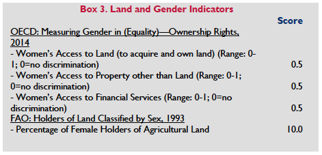 Burma’s newest land legislation – the Farmland Law and the VFV Law – is not conducive to equal rights for women. Rather than explicitly recognizing women’s equal rights, these laws state that land will be registered to the head of a household, which in Burma is understood to mean the husband. In addition, these laws appear to lack a mechanism for joint ownership of property by a husband and wife, and do not explicitly state the equal rights of women to inherit land or be granted use rights for vacant, fallow or virgin land. (Displacement Solutions 2012; Oberndorf 2012; Faxon 2015; Srinivas and Hlaing 2015).
However, the NLUP contains provisions that could lead to a strengthening of women’s land rights. One of its guiding principles is the promotion of participation by women in decisions concerning land and natural resource management. It explicitly seeks to recognize and protect the land tenure rights of women (and others). The policy provides that the new national land law should provide women with rights equal to men in all aspects of land tenure, land management, land use and related decision-making (National Land Use Policy 2016).
Women’s land rights vary by religious affiliation. As discussed above, Buddhist, Muslim and Hindu customary laws have the force of formal law for their respective populations in matters of succession, inheritance and marriage. The Buddhist Women’s Special Marriage and Succession Act of 1954, which applies to Buddhist women in these matters, also codified some Buddhist customary law.
Burma’s government has reported that customary Buddhist law dictates that Buddhist women – a group that includes the majority of women in Burma – have rights equal to their husbands’ regarding the ownership of property and are “co-owners” of property rather than “joint-owners.” Property rights for Buddhist wives vary to some extent based on the type of property. Husbands and wives are entitled to one-third of: the property owned by the other spouse at the time of marriage (paryin); and property that their spouse inherited. They are entitled to equal shares of: property accumulated or increased after marriage (lathtatpwar); property gifted to the couple upon their marriage (khanwin); and property earned by both parties’ work (hnaparson). Neither spouse is entitled to property brought by the other into their union from a previous marriage (ahtatpar) (CEDAW 2007).
Under customary Buddhist law, one spouse cannot dispose of co-owned property without the other’s permission, and neither party can dispose of property through a will. Rather, co-owned property passes to a wife when her husband dies, and vice versa. The government has reported that Buddhist customary law treats parties equally in matters of inheritance, and that “there is no discrimination in inheritance for being man or woman, husband or wife, widower or widow, son or daughter, and grandson or granddaughter.” Instead, partition is decided based on the degree of relationship with the deceased benefactor. Sons and daughters are entitled to inherit equally. In the case of a polygamous marriage, the major share of property goes to the first wife and her children, and smaller amounts are apportioned successively to the other wives and children (COHRE 2007; CEDAW 2007).
As for Muslim and Hindu women, the 1898 Burma Laws Act provides that Islamic and Hindu customary laws govern matters of succession, inheritance and marriage. The succession, inheritance and marriage rights of Christians are determined by the Christian Marriage Act, the Burma Divorce Act (which applies only to Christians) and the Succession Act of 1925. The laws applicable to Christians provide very few guidelines regarding the division of property in the case of divorce, and the question is usually decided by a court based upon the reasons for divorce (Leckie and Simperingham 2009; Gutter 2001; Sen 2001).
The government has not harmonized Burma’s codified laws, which include the various religious acts governing marriage and property, with the plethora of customs practiced by various groups across the country. Many of these customs provide men greater economic and decision-making power in domestic affairs. These practices govern many women’s lives, particularly as the government is not actively present in many rural areas (WLB 2008).
Customary laws in some ethnic regions effectively discriminate against women’s rights to land. For example, in some rural areas of Shan State, the traditions of the largely Buddhist Palaung population dictate that in the case of divorce a wife loses all jointly held property. In addition, men inherit all of their parents’ property and make all decisions about the disposal of property, including the disposal of property through inheritance. Property goes to sons in the case of a husband’s death or, if he has only daughters, to his brothers (WB 2014; WLB 2008; Transnational Institute 2015).
LAND ADMINISTRATION AND INSTITUTIONS
The change in government in 2016 may lead to significant changes in the structure of land administration institutions in Burma. Currently, the MoALI is responsible for implementing national policies on agriculture. It is comprised of thirteen departments, including six that are responsible for planning, water resources, irrigation, mechanization, settlement and land records. Myanmar Agricultural Services (MAS), MoALI’s largest unit, is responsible for field operations relating to extension, research, land use, seed multiplication and plant protection. The Irrigation Department, also within MoALI, oversees all aspects of irrigation design, construction, operation and maintenance. Other major departments are the DALMS), several State Economic Enterprises, and the Agricultural University at Yezin. The DALMS oversees land management, administers the land-tax system and conducts national agricultural surveys following cropping periods. Following passage of the 2012 Farmland Law and the Vacant, Fallow and Virgin Lands Management Law (VFV Law) the DALMS is responsible for recording and registering interests in farmland and for issuing LUCs to farmers whose use rights have been approved by Farmland Management Body. The GAD takes the lead on management of vacant, fallow and virgin lands (Oberndorf 2012; UNDP n.d.; Saw 2014).
Both MAS and the DALMS maintain staff at state, division, district and township levels. Other MoALI departments active at the field level maintain and coordinate their presence through Agricultural Supervision Committees (ASCs) (UNDP n.d.).
The 2012 Farmland Law created the Farmland Management Body (FMB), which replaced the former Land Committee. It is comprised of officials from MoALI and DALMS. The central FMB forms FMBs at the region, state, district, township, ward and village tract levels, and delegates responsibilities to them. Delegated responsibilities include: reviewing applications for farmland use; formally recognizing and approving rights to use farmland; submitting approved farmland rights to the DALMS for registration; conducting farmland valuations for tax and compensation purposes; issuing warnings, levying penalties and rescinding use rights where use conditions are not met; and resolving disputes relating to farmland allocation and use. The central FMB provides “guidance and control” relating to: land disputes; certain transfers of land use rights; shifting taungya cultivation; allocation of alluvial land; and issuance and registration of LUCs. In addition, the central FMB revokes land-use rights under various circumstances and approves regional and state-level requests to use farmland for certain purposes, such as for housing and human settlement (Oberndorf 2012; UOB Farmland Law 2012b).
The 2012 VFV Law also created the CCVFV, a national level multi-ministerial body formed at the president’s discretion. In coordination with relevant ministries and regional and state governments, the committee oversees the granting and monitoring of use rights for virgin, vacant and fallow lands for agricultural, mining and other purposes. According to the VFV Law, the committee’s responsibilities include: receiving various ministry and lower-level government recommendations for the use of vacant, fallow and virgin land; receiving land-use applications from individuals, private investors, government entities and nongovernmental organizations; rescinding or modifying vacant, fallow and virgin land use rights; helping right holders obtain technical assistance, inputs and loans; and resolving disputes related to vacant, fallow and virgin land use in coordination with other government entities. The committee is also responsible for forming task forces and special groups at the regional and state level for scrutinizing applications for use rights; as well as special boards to determine right holder compliance with granted use rights (Oberndorf 2012; UOB Foreign Investment Law 2012c).
The Ministry of Natural Resources and Environmental Conservation (MoNREC) is responsible for all land designated as forest land and mining lands. There are reports of tension between MoALI and MoNREC in relation to land governance and administration responsibilities (Faxon 2015).
In July 2012, the government formed two new entities in recognition of the need to address land classification, land tenure insecurity and land-related conflict in Burma. The Land Allotment and Utilization Scrutiny Committee, a cabinet-level body in the executive branch, was focused on national land-use policy, land use planning and allocation of land for investment. It was disbanded in October 2014 and replaced with the National Land Resources Management Central Committee which continued to lead work on developing a National Land Use Policy under the leadership of MoNREC. The National Land Resources Management Central Committee was recently disbanded by the2016 Government. The Land Confiscation Inquiry Commission, subsequently renamed the Farmland Investigation Commission, was a parliamentary body within the government’s legislative branch. It investigated land disputes and whether confiscation has been carried out in compliance with the law. It commenced work in September 2012 and prepared a number of reports on unresolved land confiscations in the country that it tasked the executive branch with resolving. A new Central Review Committee on Confiscated Farmlands and Other Lands was appointed in mid-2016 to attempt to resolve land disputes and return land to dispossessed farmers. It has vowed to resolve all “land grabbing cases” within six months (Myanmar Times 2012a; Oberndorf 2012; MCRB 2015; The Irrawaddy 2016f).
Burma’s previous president appointed a National Human Rights Commission. In 2014, complaints involving land disputes were more numerous than any other category. Although the commission has indicated interest in addressing these, it is not clear that the resolution of land disputes lies within its mandate. (Displacement Solutions 2012; Human Rights Commission 2015).
LAND MARKETS AND INVESTMENTS
According to a 2003 report by the Ministry of Agriculture and Irrigation, the number of household-based agricultural landholdings in Burma grew by 20 percent between 1993 and 2003, and the total area for such holdings increased by 25 percent. From 2003 to 2010 the number of such holdings increased by 49 percent. From 2003 to 2010 the number of holdings of less than 1 acre dropped by 48 percent while holdings of 50 acres or more increased by 114 percent. As of 2010 20 percent of households controlled 69 percent of all farmland. The dramatic increase in private landholdings may be due to the expanded cultivation of “wasteland” following a 1991 directive on the management of cultivable, fallow and waste land. From 1993-2003, commercial landholdings increased by 900 percent, and the total area for those holdings increased by 325 percent.
In recent years, Burma’s government has attempted to liberalize the country’s economy and overhaul its agricultural economy, including by granting national and foreign private entities the right to use land. As of March 2013, the government had granted concessions for more than 900,000 hectares of VFV agricultural land to 377 companies (Woods 2011; Displacement Solutions 2015; Srinivas and Hlaing 2015).
The price of land in Burma has increased dramatically in recent years. Property is changing hands for well over US $1 million in urban areas, even in areas where one might find apartments without electricity or running water. Rural areas, too, are experiencing price appreciation. The increase is partly due to artificial inflation in the wake of heavy investment by Burmese who have surplus capital but lack investment options outside the real estate market. It also relates to land speculation, which has increased along with anticipation of foreign investment following the end of military rule and a period of rapid economic and political reform. High prices do not seem to have been effected by a steep drop in demand for commercial properties in urban centers (Displacement Solutions 2012; Myanmar Times 2012b; Business World 2012; Myanmar Insider 2015; Irrawaddy 2016b).
There is concern that land speculation and price inflation are deterring foreign companies from participating in Burma’s land market. At the same time, there are claims that interest from some foreign and local businesses may be leading to land confiscation (Displacement Solutions 2012; Myanmar Times 2012b; Business World 2012; Myanmar Insider 2015).
Numerous factors may be hindering development of a formal land market that is inclusive of smallholders and protective of their rights and interests. Non-business land users may be deterred from participating in the registration process established under the 2012 Farmland Law, as the process is difficult to navigate and they have long distrusted the government and may see the registration authorities as biased. In addition, the deed registration process previously described is lengthy and complicated and parties to land transactions often seek to avoid payment of land transfer taxes. Further, little information about development plans and land values is available to the public. This lack or information particularly affects smallholders, who may be tempted to dispose of their land at too low a price. These factors create incentives for the development of a large informal land market that bypasses the official system (Myanmar Times 2012b; Business World 2012; Displacement Solutions 2012; Srinivas and Hlaing 2015).
As of 2012, several new laws govern the process for acquiring and transferring rights to agricultural and other types of land in Burma. The 2012 Farmland Law provides the process for procuring farmland, and permits the purchase, sale and transfer of farmland on a land market. While farmers have acquired and transferred land informally for years, this law allows and formalizes privately negotiated property transfers for the first time since 1953. It appears that the difficulty smallholders are having in navigating the LUC process (described below) is hindering the establishment of a formal land market (Displacement Solutions 2012; Srinivas and Hlaing 2015).
According to the Farmland Law (2012), farmers must apply for a land use certificate (LUC) through a Farmland Management Body (FMB) at the ward or village level. That body passes the request to a township land records department, which scrutinizes and then sends the request to a township FMB. A district FMB must provide final approval. Once final approval is obtained, and once the applicant pays fees and registers with a township land records department, the district FMB should issue an LUC. According to the Farmland Law, those with farmland use-rights must register any changes in the status of their right, for example if the use right is encumbered with debt, transferred or inherited. It has been reported that the government has issued over eight million LUCs, though there have been concerns with the accuracy of these LUCs due to the rushed nature of the process. Further an average of 7 percent of farmland-owning households contested some point of the LUC issuance process. (Oberndorf 2012; UOB Farmland Law 2012b, GRET 2016).
The Vacant, Fallow and Virgin Lands Management Law (VFV Law) of 2012 governs the process for obtaining access to vacant, fallow and virgin lands. Public citizens, private sector investors, government entities and others may acquire rights to use this land by submitting an application to the Central Committee for the Management of Vacant, Fallow and Virgin Lands. The VFV Law, in conjunction with the Farmland Law, recognizes that farmers are already using vacant, fallow and virgin land without formal government permission, and outlines a basic mechanism for them to obtain an LUC and have the land reclassified as farmland (Oberndorf 2012).
Foreigners may obtain land use rights by submitting proposals to the Myanmar Investment Commission, which is charged with: examining and accepting investment proposals; issuing permits; scrutinizing whether investors abide by the Foreign Investment Law; and suspending businesses that fail to abide by it. As mentioned above, foreigners face restrictions in using agricultural land. Foreigners may contract to use land for agriculture or livestock rearing only through joint ventures with local investors, and cannot acquire any category of land from a citizen without government permission (UOB Environmental Conservation Law 2012a; UOB Farmland Law 2012b).
COMPULSORY ACQUISITION OF PRIVATE PROPERTY RIGHTS BY GOVERNMENT
The 1894 Land Acquisition Act remains the primary law governing compulsory acquisition in Burma (UOB Land Acquisition Act 1894; Displacement Solutions 2012).
The Land Acquisition Act permits the government to acquire land for public purposes and business purposes. While it does not provide detail on the meaning of public purpose, it defines the latter as for “a company constituted or registered by or under the law of the United Kingdom, the Union of Burma or India or Pakistan,” including “a society registered under the law of the Union of Burma or India or Pakistan relating to the registration of societies or co-operative societies” reflecting the urgent need to update this law. Parliament has a new Land Confiscation Act under consideration (UOB Land Acquisition Act 1894, Arts.3,6; Irrawaddy 2016c).
The Act includes procedures governing: the state’s provision of notice; how right holders can object to the acquisition; land valuation; the state’s taking possession of land; right holder appeals; and state acquisition of land for use by corporations. Although the Land Acquisition Act requires the government to compensate land users, Burma lacks a standard methodology for determining the amount of compensation; the country also lacks an independent body to govern the process. In practice, compensation often falls short of minimum standards for just compensation, or does not occur at all (Displacement Solutions 2012; MCRB 2015; Displacement Solutions 2015).
Land users face state confiscation in a variety of circumstances outside of these laws and procedures. According to the 2012 Farmland Law, the government may rescind use rights if a farmer breaches conditions for land use, for example by: failing to pay registration fees; failing to provide a sound reason for leaving land fallow; or by growing crops other than the “regular crop” without permission. The law does not provide clarity on the definition (or source for the definition) of “regular crop.” It does, however distinguish between irrigated paddy land and other types of farmland. According to the Farmland Law, farmers cannot change the use of irrigated paddy land without obtaining permission from the government at the national level, and those who do so could lose their use rights to such land. This restriction is understood to be related to domestic food security concerns and to the fact that the government provides for and maintains the irrigation systems for irrigated paddy land. The Farmland does not include any provision for appeals by those whose land has been confiscated (UOB Farmland Law 2012b, Art.12; Oberndorf 2012; Oberndorf 2013; MCRB 2015; Displacement Solutions 2015).
Hillside cultivation (or taungya) is estimated to account for 30–40 percent of all cultivation in Burma, and is especially common among communities in the Upland area. Language in the 2012 Farmland Law and the VFV Law has placed smallholder farmers and communities practicing shifting cultivation in upland areas at risk of having their land confiscated. Although the Farmland Law recognizes taungya land in its definition of farmland, bylaws introduced by the MoALI interpret the category of taungya land as referring only to fields under permanent cultivation. The government’s interpretation of “permanent cultivation” (for example whether it includes short fallow cultivation, which is necessary in order to allow fields to rotate) will have critical implications for many smallholder farmers. The government’s interpretation of “abandoned” will matter greatly as well. Moreover, much of the land in the uplands areas is not classified as farmland so the Farmland Law does not even apply. Much of this land actually falls within one of the categories of Forestland, over which gaining recognized tenure is very difficult. According to the VFV Law, vacant and fallow land is that which a tenant has cultivated in the past, but which the tenant subsequently abandoned for any reason. Depending on the government’s interpretation through subsidiary rules and regulations, taungya land and other land under traditional and community use could be considered vacant or fallow and subject to allocation to private companies and others. In addition, land used by farmers implementing very long fallow rotations and by groups following traditional community forestry arrangements could take on the characteristics of “virgin” land, putting those groups at risk of having their land confiscated. Moreover, the VFV rules give the government the power to repossess VFV land so as to use it for basic infrastructure or other projects of special interest to the government. As with the Farmland Law, the VFV Law does not include any process for objecting to confiscation (Oberndorf 2012; Oberndorf 2013; LRAN 2012; Kean 2012; MCRB 2015).
LAND DISPUTES AND CONFLICTS
Natural resources are a leading source of conflict. Most natural resources are located in areas where ethnic military groups operate, including groups that observe a ceasefire with government forces and groups that do not. Projects to develop these assets have often resulted in land confiscation and involved Burma’s military forces, which have a well-documented history of displacing and violently abusing affected populations. Eastern Burma, for example, has experienced increased militarization following plans to build a series of dams on the Salween River. Armed conflict has erupted in this area, where there has been widespread displacement of people from their land, homes and livelihoods. In one instance in the Sagaing region in 2012, the planned expansion of the Monywa copper mine, which is supported by the military-owned Union of Myanmar Economic Holdings Ltd. and a unit of the China North Industries Corporation, resulted in the confiscation of 7800 acres of land and the displacement of four villages. Riot police suppressed ensuing protests, resulting in dozens of injuries. Ongoing protests against the Dawei Economic Zone, the Letpadaung Copper Mine and the Myitsone Dam have sometimes turned violent (BEWG 2011; COHRE 2007; Faxon 2015).
The extent to which the military is involved in land confiscation may have changed following Burma’s recent political changes, although this is unclear. Historically, land confiscation has sometimes taken place independently of development projects (and outside formal procedures for compulsory acquisition) in regions experiencing an expansion of armed forces and patterns of militarization. Various reports have documented illegal appropriation of farmland by senior government and military officials, including instances where land was confiscated for use by officials or as a means of punishing those opposing military objectives (COHRE 2007; BEWG 2011; Tun 2012; Zaw and Khaing 2013).
Displacement due to conflict is a major issue. Internal conflict in the northern and eastern ethnic regions have displaced hundreds of thousands of people. Intercommunal violence in Rakhine State has displaced 140,000 members of a Muslim minority group known as the Rohingya since 2012. Historically, the government has confiscated land occupied by the Rohingya, sometimes making it available to Rakhine Buddhists. The Rohingya have been subjected to violent attacks from anti-Rohingya Buddhist groups (MCRB 2015; Yale 2015).
There is some concern that a rise in foreign investment could increase tensions and conflict. Most foreign investment has been concentrated in the energy and extractive industries, which have been tied to contested or unlawful land confiscation, displacement and violence. Of particular concern, more recently is state confiscation of land for commercial agricultural development, which has been a growing source of grievance for local populations. Land acquisition and allocation processes have generally been characterized by a lack of transparency and accountability, presenting a risk that smallholder rights will be ignored or violated as agribusiness activity increases. In Kachin State, for example, villagers reported in 2007 that Yuzana Co. Ltd. had seized their farmland with assistance from the army. The company claimed to have received the land from the government for an agricultural project, while villagers claimed that they lost their land by force and received no compensation. Farmers’ increasing protest of the confiscation of land for agriculture projects has caught the attention of the central government (COHRE 2007; Irrawaddy 2007; Irrawaddy 2013; LRAN 2012; Reuters 2012; BEWG 2011; Landesa 2013; Transnational Institute 2013a; MCRB 2015; Displacement Solutions 2015).
As discussed above, the government has formed a new committee to address the high level of land-related disputes in Burma. Previously the Parliamentary Land Acquisition Scrutiny Commission, subsequently renamed the Farmland Investigation Commission, was tasked with reviewing cases of government land acquisition extending as far back as twenty years but only up through 2011. This commission’s inquiries include: whether acquisition rules were followed; whether compensation was paid; the purpose of projects related to acquisitions and whether such projects were executed in accordance with original plans. It has no authority to take action to resolve cases. The commission commenced work in September 2012 when members of parliament from several parties began collecting evidence related to a number of land acquisitions, including in Tenasserim Division and Arakan, Mon and Karen States. Although the Land Acquisition Scrutiny Commission’s initial missions have raised expectations that land-related grievances will be addressed, members of the Commission were not trained in fact finding and did not have any authority to conduct dispute resolution based on what they found. Rather, the information they collected will be used to inform the parliament’s legislative-reform initiatives. The Commission issued a report in 2013 regarding land expropriations by the military. It found, among other things, that the military had forcibly acquired about 250,000 acres of land, often taking more land than it needed, and sometimes failed to comply with the Land Acquisition Act. In addition, in its first two years the Commission received 30,000 complaints of land having been taken without lawful compensation. As of 2015 the commission had investigated about 20,000 cases and found proper compensation in fewer than 1,000. In addition, the government has just established a new Central Review Committee on Confiscated Farmlands and Other Lands which is tasked with reviewing the handling of land disputes by state and regional governments and facilitating the return of land to farmers who had lost it to state-owned enterprises, private companies and the government, or ensuring that adequate compensation is paid to those whose land is taken. (Irrawaddy 2012; Oberndorf 2012; Oberndorf 2013; Economist 2012; Irrawaddy 2013a; MCRB 2015; Myanmar Times 2015; Irrawaddy 2016a).
While the Land Acquisition Act governs the process for compulsory acquisition, including procedures for contesting acquisition, the 2012 Farmland Law and the Vacant, Fallow and Virgin Land Management Law (VFV Law) also contain provisions relating to the settlement of certain land disputes. The processes outlined in the Farmland Law have been criticized as not providing meaningful due process for those facing the loss of their land (Displacement Solutions 2012; Displacement Solutions 2015).
Under the 2012 Farmland Law, a court may decide disputes related to inheritance of farmland. However, there is no mechanism in the Farmland Law that allows other disputes involving the allocation or use of farmland to come before a court of law. For these disputes, farmers must bring their complaint before a ward or village tract level Farmland Management Body, the same entity responsible for the contested decision. Complainants dissatisfied with a FMB’s decision at the ward or village tract level may appeal to a township FMB, district FMB, and then to a region or state level FMB, whose decision is final (UOB Farmland Law 2012b; Displacement Solutions 2012; Oberndorf 2012).
As for vacant, fallow and virgin lands, the VFV Law appears to give the CCVFV a role in resolving disputes related to allocation and use. Unlike the Farmland Law, the VFV Law does not explicitly restrict one’s ability to file an appeal to the judicial branch (Oberndorf 2012).
The NLUP includes a number of provisions intended to avoid and improve the resolution of disputes over land. Both the objectives of the policy and its guidance principles urge the development and use of equitable, accessible and transparent dispute resolution mechanisms. The policy goes on to call for the establishment of special land tribunals, the use of independent arbitration panels, resort to customary dispute resolution processes where appropriate and independent monitoring of land dispute resolution mechanisms and outcomes (National Land Use Policy 2016).
DONOR INTERVENTIONS
After long gaps in funding, Burma has attracted considerable support from development donors beginning in about 2012. In November 2012, the World Bank, which has not funded development projects in Burma since 1987, approved $80 million over the next six years for the Myanmar National Community Driven Development Project, aimed at improving infrastructure and services in poor rural communities. The bank approved an additional $400 million for the project in 2015. There are no direct land tenure components in the project. The bank plans to conduct a Land Governance Assessment Framework analysis in Burma (World Bank 2012c World Bank 2015b).
In the second half of 2012, the Asian Development Bank (ADB) adopted a 2-year country partnership strategy that has been extended through 2016. Under the strategy ADB has provided funding for a gender situational analysis, improved roads and power plants, among other things. (ADB 2012c; ADB 2015).
After a 23-year hiatus, the United States reopened the USAID mission in Burma in July 2012. In November 2012, President Barack Obama announced a partnership between the United States and Burma aimed toward advancing democracy, peace and prosperity. Since that time, investments for all USAID-led projects amount to $660 million to strengthen democracy, human rights and rule of law; provide humanitarian assistance; advance peace and reconciliation; and encourage economic development, food security and global health. The Prosperity component of the partnership includes encouraging the development of fair and equitable land tenure policies as part of a comprehensive approach to improve food security in Burma. To that end, USAID has supported technical assistance to the government in developing the new National Land Use Policy. USAID has also contributed to agriculture projects funded by LIFT (see below) and co-chairs the donor Agriculture and Rural Development Sector Working Group (USAID 2012b; USAID 2012a; USAID 2013; USAID 2014).
USAID provided significant support to development of the NLUP through the Tenure and Global Climate Change Project. The project made available to the government a full-time land tenure expert based in Burma to support the government, civil society and others in connection with drafting the NLUP and supporting inclusive multi-stakeholder public consultations. The project is also funding some pilot projects on land tenure and property rights, emphasizing the rights of women and conflict mitigation. It is expected to continue through 2017 (USAID 2015).
The Livelihoods and Food Security Trust Fund (LIFT) is a multi-donor trust fund with the goal of reducing the prevalence of poverty and hunger in Burma. In addition to donations from the United States, it has received a total of $210 million in funding from Australia, Denmark, the European Union, France, Ireland, Italy, the Netherlands, New Zealand, Sweden, Switzerland, the United Kingdom and, most recently, Mitsubishi Corporation. Originally established as a five-year fund, LIFT has been extended twice, most recently through 2018. Its recent support for efforts to improve land governance include funding a multi-stakeholder group known as the Land Core Group, a UN Habitat program that supports improved land administration (known as LAMP) and a research project by the NGO GRET on rural land issues (LIFT 2014; UN Habitat 2016).
The Swiss Development Corporation (SDC) is funding the OneMap Myanmar project to provide 8 years of technical support for creation of a government-managed open access database on information related to land and development. SDC and the German Federal Ministry for Economic Cooperation and Development (BMZ) are investing $10 million for the first 4 years of a 10-year project called the Mekong Region Land Governance Project. The goal of the project is to improve land policies and practices in Burma, Cambodia, Laos and Vietnam to benefit family farmers and communities. SDC also provided technical and other assistance to the development of the NLUP. (MRLG 2016; GIZ 2015; Centre for Development and Environment 2015; National Land Use Policy 2016).
In addition, the British Department for International Development (DFID), the Swedish International Development Agency (SIDA) and the Danish International Development Agency (DANIDA) have supported Pyoe Pin, a domestic NGO whose work includes efforts to improve land governance in Burma (British Council 2016).
The European Union (EU) resumed full engagement with the Burmese government in May 2012. In addition to providing funding to LIFT, EU-funded interventions in Burma have focused on strengthening civil society organizations, including those addressing human rights. The EU has also supported the creation of a National Land Inventory, piloting efforts to improve district land use planning and provided support for development of the NLUP (EC 2013a; EC 2013b; EC 2014; National Land Use Policy 2016; Jewell 2013).
Other donors have contributed relatively continuously to projects in Burma, generally through United Nations agencies, regional organizations and international nongovernmental organizations (NGOs). The Australian Agency for International Development (AusAID) has been one of Burma’s largest donors, including its contributions to LIFT. As part of its sustainable economic development priority, an AusAID-funded project in Rakhine State helped 2700 households secure 30-year, potentially renewable, LUCs, strengthening tenure security and ensuring a source of household income. The effort was part of the Rakhine Rural Household Livelihood Security Project, implemented by CARE Australia, from 2005 to 2011. AusAID, along with FAO and the EU, then provided funding for a follow-on project, Strengthening Partnerships and Resilience of Communities in northern Rakhine State (SPARC), to build on the success of the previous project in the region. (AusAID 2010; AusAID 2012b; AusAID 2012c; AusAID 2015).
The Food and Agriculture Organization (FAO) is currently funding several agriculture- and food security- related projects in Burma, one of which is technical assistance with the 2010 Agricultural Census. It is assisting the government to incorporate the principles of the Voluntary Guidelines on the Governance of Tenure into its legal framework (FAO 2012a). In addition, the EU-FAO FIRST Programme has provided a full-time land advisor to the newly formed Agriculture Policy Unit in MoALI.
The Japan International Cooperation Agency (JICA) has provided financial support for the development of the Thilawa Special Economic Zone, which has been criticized for not respecting the land rights of some of those living in the area (JICA 2014).
Freshwater (Lakes, Rivers, Groundwater)
RESOURCE QUANTITY, QUALITY, USE AND DISTRIBUTION
Burma has six major river basins: the Irrawaddy, the Sittaung, the Rakhine, the Tanintharyi, the Thanlwin and the Mekong (the latter two of which originate in China). The country has an estimated 1080 and 493 cubic kilometers per annum of surface and groundwater potential respectively, placing it fourteenth globally in terms of available water resources. However, Burma uses only 5 percent of its water resources, or 45 million acre feet (56 cubic kilometers). Renewable internal freshwater resources per capita have gradually declined from 26,812 cubic meters in 1987 to about 19,000 in 2011. Irrigated agriculture is the largest consumer of water resources, accounting for over 89 percent of withdrawals. Ten percent is used for municipalities, while 1 percent is used for industries (ADB 2008; UOB 2006b; World Bank 2012a; UNDP n.d.; FAO 2011a; ADB 2014; RVO 2014).
These abundant water resources are unevenly distributed both temporally and spatially. Out of the country’s 63 districts, four are severely water scarce and another seven are considered medium to severely water scarce. An estimated 91 percent of total water withdrawal comes from surface water, while 9 percent comes from groundwater. As a result, distribution is largely predicated on rainfall, 80 percent of which arrives during monsoon season (May–October). Climate change is expected to result in more intense rainfall which, in combination with increased deforestation, may cause greater watershed runoff and a higher risk of floods (FAO 2010; UNDP n.d.; ADB 2014; RVO 2014).
70 percent of Burma’s people live in the Irrawaddy River basin, which covers 60 percent of the country’s landmass. It has an average annual flow in excess of 400 million cubic meters. More productive and sustainable use of the water from this river is seen by some as considerably important to reducing poverty in Burma, but management of the basin has been hampered by institutional weakness in the government (WB 2014).
Burma has increased the area of irrigated land through sustained investment in irrigation water-storage capacity and irrigation management. By 2014, the Irrigation Department had constructed about 240 dam and irrigation projects with the capacity to irrigate 2.13 million hectares. The ratio of irrigated area to irrigable area grew from 40 to 50 percent between the period 1997–1998 and 2002–2003. However, as of 2013-14 only about 16 percent of agricultural lands were irrigated. Expenditure on irrigation management as a percentage of total investment of the Irrigation Department increased from about 10 to 25 percent between 1995–1996 and 2004–2006. The volume of irrigation water-storage capacity increased by a factor of twenty-seven from 1988 to 2003 (UOB MoALI 2014b; FAO 2011a; ADB 08; ADB 2014).
Between 1990 and 2009 a total of 252 dams and reservoirs were built in Burma. As of 2014 about 88 new hydropower projects had been proposed. Burma’s current hydropower capacity is about 5,000 megawatts out of a hydropower potential of 100,000 megawatts, indicating that the country is using only 1 percent of its potential (ADB 2014; FAO 2011a; BEWG 2011; Myanmar Times 2015a).
Burma has made substantial progress in providing its population with safe drinking water. From 1995 to 2003, access to safe drinking water increased from 50 to 74 percent in rural areas and from 78 to 92 percent in urban areas. As of 2012, 86 percent of the population had access to improved drinking-water sources but the percentage of the population with access to clean water in urban areas had actually begun to shrink, probably due to rural to urban migration and rapid urbanization. This indicates that substantial progress remains to be made in providing the entirety of the population with access to clean water. Lack of investment in water-related infrastructure has undermined public health, especially in urban areas. Inadequate water treatment facilities and a lack of water supply in some areas have resulted in an increase in illnesses, such as diarrhea, malaria and dengue fever (ADB 2008; FAO 2011a; ISF-UTS 2011; ADB 2014).
Water pollution is increasing. Contributing factors are: the drainage of water or chemicals used in mineral extraction; overuse of pesticides; industrialization; excess siltation from watershed erosion caused by logging, mining and large-scale agriculture; and the dumping of industrial and human wastes and garbage. Arsenic contamination as a result of gold mining constitutes a particularly acute threat to groundwater contamination. However, the relative abundance and public preference for rainwater in much of the country has somewhat mitigated this threat. The Burmese government has established institutions and policies that acknowledge Burma’s water resource challenges. However, the institutions established are not integrated with one another, and also lack the authority to implement policy (BEWG 2011; BEWG 2012; LEI 2002; ISF-UTS 2011; BEWG 2011; Myint 2007; ADB 2014; RVO 2014).
LEGAL FRAMEWORK
The government adopted a National Water Policy (NWP) in 2014. It was developed by the National Water Resources Committee organized in 2013. Work has begun on drafting a National Water Law based on the NWP but it has not yet been enacted. The NWP aims to incorporate an integrated water resource management approach throughout the country’s water management institutions and laws so as to sustainably and equitably manage and share water in Burma (World Bank 2014; Myanmar Water Partnership 2014).
Thus, for now there is no single law governing all aspects of water resources. The 2006 Conservation of Water Resources and River Law prohibits pollution of water resources and specifies penalties. This law is primarily concerned with river transportation and the regulation of river fishing and sewage discharge. It authorizes the Directorate of Water Resources and Improvement of River Systems to determine dangerous water levels for towns; cooperate with relevant government departments and organizations to solve related problems; and guide the use river water for domestic and agricultural use. The law: prohibits water pollution; prescribes terms and conditions for the monitoring and prevention of water pollution; and specifies penalties for those who pollute water. The 1994 Protection of Wildlife and Natural Areas Conservation Law also specifies penalties for water pollution (UOB Conservation of Water Resources and Rivers Law 2006a; UOB Protection of Wildlife and Natural Areas Conservation Law 1994).
The 1993 National Health Policy seeks to intensify and expand environmental health activities, including the prevention and control of air and water pollution. (WHO n.d.).
The 2012 Vacant, Fallow and Virgin Lands Management Law (VFV Law) establishes the CCVFV to coordinate with the MoNREC (formerly the Ministry of Environmental Conservation and Forestry) and other ministries concerned with the conservation of natural regions, watershed area and natural fisheries (UOB Vacant Fallow and Virgin Lands Law 2012d).
A number of laws and policies concern the management of irrigation water supply and urban water resources. The Canal Act (1905, last amended in 1998) regulates the allocation of water for public purposes, water supply and drainage works. The Act permits all water in all rivers and streams flowing in natural channels as well as lakes and other national still water bodies to be used and controlled for public purposes. The Myanmar Embankment Act (1909, last amended in 1998) requires every owner or occupier of immovable property in the vicinity of an embankment to help maintain the embankment or to provide a laborer who can. The Act authorizes an embankment officer to enter into any immovable property in the vicinity of an embankment and take possession of, appropriate or remove and use any relevant materials for the purpose of such work (Gutter 2001; Leckie 2009; WEPA 2008; BEWG 2012).
Urban water resources and groundwater are governed by the City of Rangoon Municipal Act (1922; amended 1958, 1961 and 1991), which defines rules regarding management and protection of the city’s water supply. The Underground Water Act (1930) deals with the conservation and protection of underground sources of water supply in Burma. The Burma Canal Act (1905; amended 1914, 1924, 1928) provides a code for regulating the construction and maintenance of canals and drainage works (Gutter 2001; Macdonall and Manson 1907; UOB 2006b).
The 1994 National Environmental Policy calls for the establishment of sound environmental policies in the utilization of water, land, forests, mineral resources and other natural resources; the policy also promotes the integration of environmental considerations into the development process.
The 1994 Protection of Wildlife and Natural Areas Conservation Law authorized the creation of the Committee for Protection of Wildlife and of Natural Areas. There is little indication, however, that this law has been implemented (UOB Protection of Wildlife and Natural Areas Conservation Law 1994a; BEWG 2011).
The 2012 Environmental Conservation Law instructs the MoNREC to implement the government’s environment policies. It instructs the MoNREC to form an environmental conservation committee in charge of mobilizing environmental conservation activities. For example, MoNREC must establish a system for monitoring pollution from industry, agriculture, and mining, and to monitor construction projects. The law also recommends, but does not mandate, that MoNREC develop an Environmental and Social Impact Assessment (ESIA) mechanism in the country which it has done. Environmental Conservation Rules were issued in 2014 (BEWG 2011; Oberndorf 2012; BEWG 2012; Myanmar Times 2016; Aye and Oo 2015).
Although the Environmental Conservation Law lacks specific requirements for water and natural resource conservation, it gives MoNREC the power to make policies regarding resource conservation. The law is binding on the government and on government projects, but MoNREC may be required to receive the central government’s permission to enforce the law on other ministries (BEWG 2012).
Burma is party to several international treaties concerning water and the environment. In 1997 the Burmese government accessed the United Nations Convention to Combat Desertification in those Countries Experiencing Serious Drought and/or Desertification, Particularly in Africa. Among its goals, the convention seeks to implement long-term integrated strategies that focus simultaneously on improved productivity of land, and the rehabilitation, conservation and sustainable management of land and water resources. The Burmese government joined the UNESCO Convention concerning the Protection of the World Cultural and Natural Heritage in 1994. The convention is intended to protect the world’s most valuable cultural and natural environments from decay and destruction (UN 1994; UNESCO 2012; SNHB 2011).
TENURE ISSUES
The 2008 Constitution reconfirms the state’s ownership of all natural resources. The constitution also requires the Finance and Planning Sectors of regions (known as divisions under prior versions of the law) and states (states and regions being of equal status in the administrative structure) to collect municipal taxes, including on water (UOB Constitution 2008a).
In general, no law prohibits the exploitation of surface or subsurface water resources in Burma. The Irrigation Department imposes a low tariff for gravity irrigation systems, such as using water from reservoirs, and does not recover the cost of maintenance work. The Union of Burma supplies the majority of the annual budget for irrigation facility maintenance and repair. The Water Resources Utilization Department imposes a higher water tariff for river pumping systems, with water prices for rice cultivation in the dam systems 150 and 300 times less than for electric and diesel river pumping systems. As a result of the lower water price, farmers’ use of water has increased, regardless of water shortages or water losses (UNESCAP 2006; FAO 2011a; Myanmar Water Partnership 2014; RVO 2014).
GOVERNMENT ADMINISTRATION AND INSTITUTIONS
There is no single institution responsible for comprehensive management of national water resources. At the ministerial level, the MoALI is primarily responsible for agricultural and irrigation water resources. Three departments within the MoALI have water management- related functions: The Irrigation Department (ID); the Water Resources Utilization Department (WRUD); and the Agricultural Planning Department (APD).
The ID and its subsidiary Irrigation Technology Centre manage irrigation works, including the planning and implementation of new surface water irrigation projects. The ID is further responsible for the maintenance and operation of major facilities such as main dams, headworks, main canals and secondary units. The responsibilities of WRUD include measuring surface and groundwater quantity and quality for drinking and irrigation purposes, and supplying drinking and irrigation water from surface and groundwater sources. The APD is responsible for planning, monitoring and evaluating all agricultural projects, including irrigation and drainage projects. The ID and the WRUD provide technical and financial assistance to farmers for private irrigation system (primarily well and pump irrigation) implementation, management, operation and maintenance. The SLRD is responsible for collecting agricultural statistics and land administration (UOB 2006b; FAO 2011a; UNDP n.d.; Myanmar Water Partnership 2014).
The Meteorology and Hydrology Department of the Ministry of Communication, Posts and Telegraphs is tasked with collecting hydrological and meteorological data. The Myanmar Electric Power Enterprise, within the Ministry of Electric Power, supervises hydropower generation. The Myanmar National Committee on Large Dams in MoALI also has some responsibility for overseeing large dams.
Farmers maintain and operate the terminal units such as field ditches and watercourses. The Forest Department is the primary agency responsible for watershed management (FAO 2011a; UOB 2006b; Myanmar Water Partnership 2014).
Under the Environmental Conservation Law, MoNREC is charged with setting rules for: how much and what type of pollution is allowed, and what businesses and individuals must do to reduce pollution; establishing a system to assess the environmental and social impacts of government and private projects; establishing a system to monitor pollution from agriculture, industry, and mining; deciding which types of projects require permission to operate; deciding whether to grant permission to individual projects; requiring companies to pay for environmental conservation projects to make up for the damage the companies cause; overseeing the system for determining the nature and extent of, and punishing, environmental damage; and negotiating regional and international environmental agreements (BEWG 2012).
The Department of Health is responsible for providing safe and clean drinking water and sanitation in rural areas. The Department of Rural Development in the MoALI has responsibility for rural water supplies (Myanmar Water Partnership 2014).
All government departments are responsible for conserving and managing resources, including forests, land, water, agricultural resources, ecosystems, biodiversity, and cultural resources. MoNREC is charged with providing advice and support on this issue to other departments. Individuals or companies that break the law can be fined or jailed, but the MoNREC can reduce or eliminate these punishments in the name of state and public interest (BEWG 2012).
The National Commission for Environmental Affairs (NCEA) was established in 1990, and came under the authority of the MOECAF, now MoNREC in 2004. It is tasked with: advising the government on environmental policies; acting as a focal point and as a coordinating body for environmental affairs; and promoting environmentally sound and sustainable development in Burma. However, significant budget and staff constraints and a lack of legislative mandate have compromised the NCEA’s ability to meet its objectives (Myint 2007; BEWG 2011).
Urban water is managed at the city level. The Yangon City Development Committee (YCDC) is responsible for water supply and sanitation in Yangon. With regards to rural water management, the Department of Development Affairs is tasked with delivering water supply services to villages. However, it is unclear how these services are managed over the longer term (ISF-UTS 2011).
The Ministry of Transport is responsible for conserving water resources in accordance with the relevant international conventions, regional agreements and bilateral agreements for environmental conservation. The Conservation of Water Resources and River Law authorizes the Directorate of Water Resources and Improvement of River Systems to determine dangerous water levels for towns, oversee the resolution of water-related problems, and determine appropriate domestic and agriculture river water use (UOB Conservation of Water Resources and Rivers Law 2006a; Myanmar Water Partnership 2014).
Overall, there is considerable administrative overlap amongst the many government departments with some responsibility for water management. The overlaps are at the national level and between national, state/regional and local levels. The National Water Policy recognizes the importance of reforming this institutional framework (RVO 2014).
In 1996, Burma and China became Dialogue Partners of the Mekong River Commission (MRC), an agreement between the governments of Cambodia, Lao People’s Democratic Republic, Thailand and Vietnam to cooperate for the sustainable development of the Mekong River Basin (FAO 2011a).
GOVERNMENT REFORMS, INTERVENTIONS, AND INVESTMENTS
The Myanmar Water Vision informed the development of the National Water Policy (NWP) in 2014. It was developed by the 3National Water Resources Committee organized in 2013. The policy is expected to lead to a National Water Law that is under development. The NWP aims to incorporate an integrated water resource management approach throughout the country’s water management institutions and laws so as to sustainably and equitably manage and share water in Burma (World Bank 2014; Myanmar Water Partnership 2014).
In 2003, the Irrigation Department, in cooperation with the United Nations Economic and Social Commission for Asia and the Pacific (UNESCAP) and FAO, launched the Myanmar Water Vision program. The program was established with the intention of improving national water resource management and conservation, including through building public awareness and participation. A Myanmar Water Resources Committee, along with a strategic management plan, was proposed in 2004 to improve the national application of integrated water resources management (IWRM). The Committee’s goals include: integrating water-related agencies; establishing national water resource management rules; initiating a pilot river basin management study; and enhancing stakeholder participation. The Committee was responsible for approving the NWP. It was disbanded in early 2016 (WEPA 2008; UOB 2006b; RVO 2014; Myanmar Times 2016a).
The Burmese government joined the United Nations Water, Sanitation and Hygiene for All (WASH) initiative in 2002. The government developed a national WASH program the following year, aiming to work with international agencies and nongovernmental organizations to increase access to safe drinking water and improved sanitation facilities while promoting good hygiene practices, especially in disaster- affected areas. As part of its WASH program, the Union of Burma has organized community engagement events and a media campaign to promote good sanitation practices nationwide. The Union of Burma is also involved in planning a WASH sector assessment (ISF-UTS 2011; WSSCC 2012; UNSDKP n.d.).
In an effort to improve agricultural yields while reducing government administration and maintenance costs, the Ministry of Agriculture and Irrigation initiated a project to promote water-licensing and strengthen water user groups. The project encourages farmers to voluntarily organize water users’ groups for irrigation purposes, enforce irrigation system management and maintain and repair irrigation facilities, with resources provided by the government. Group leaders are nominated by participating farmers and approved by the Divisional Canal Officer (GWP 2008).
In 2007, the government signed an agreement with China Power Investment Corporation to construct seven large dams in Kachin state. The largest, the Myitsone Dam, was suspended in 2011, after violent protests by local opposition groups as well as international outcry over the lack of project transparency and the dam’s potential social and environmental impact. If completed, the Myitsone dam will: have a capacity of 6000 megawatts; flood an area larger than Singapore in one of the world’s most disputed biodiversity hotspots; and displace an estimated 10,000 people. As of 2014 about 88 new hydropower projects had been proposed with 44 in the planning stages. Two additional hydropower dams, the Hatgyi and Tasang dams, are proposed on the Thanlwin river. There are plans for 13 dams on the Salween River. One, the “Mong Ton” project would generate 7,000 megawatts of electricity, mostly for export. It, too, has generated fierce opposition. There are reports of a number of armed clashes between armed ethnic groups and the government in connection with hydroelectric projects (Eleven Media 2012; FAO 2011a; BBC 2011; Doran et al 2014; International Rivers Watch 2014; Osborne 2015; Herman 2015; Brennan and Doring 2014).
DONOR INTERVENTION AND INVESTMENTS
In 2008–2009, FAO and the European Commission carried out a project entitled Support for Sustainable Agriculture and Rural Livelihoods in Northern Rakhine State (NRS) of Myanmar. Project objectives included crop intensification and diversification, including the development of water harvesting and localized small-scale irrigation. In addition, FAO has funded a number of watershed protection and rehabilitation projects in Burma (FAO 2011b; FAO 1997).
A number of donors are actively involved in WASH programming in Burma, including UNICEF, the UNDP, UNHCR and UN-Habitat. UNICEF recently initiated training in Community-Led Total Sanitation (CLTS) and began piloting CLTS in villages, with plans to scale up (ISF-UTS 2011; UNICEF 2014).
ADB funded the Irrigation Command Area Development Project, designed to improve irrigated agricultural productivity in the Dry Zone. The Enhancing Rural Livelihoods and Income Project included support for small community irrigation and drainage systems and potable water systems. Similarly, UNDP is supporting a project called “Addressing Climate Change Risk on Water Resources and Food Security in the Dry Zone of Myanmar,” a climate change adaptation project that, among other things, seeks to ensure an adequate supply of clean drinking water to households in the Dry Zone (ADB 2013; ADB 2013a; UNDP 2015).
Japan has financed Three Cities Water Supply Improvement Program, aimed at improving water infrastructure for Yangon City and Pathein City, and Mawlamyine City. JICA will fund a similar project for the city of Mandalay. Previously, JICA completed the Project on Rural Water Supply Technology in Central Dry Zone in 2009. Many wells in this area had fallen into disrepair, while local Department of Development Affairs (DDA) staff lacked the expertise to maintain them. The project sought to provide safe drinking water to local inhabitants by digging twenty new deep tube wells (200 to 300 meters) as well as repairing the forty tube wells already in existence. Further, the project sought to upgrade the technical capabilities of the DDA, and establish a system to manage and maintain village water supply facilities (JICA 2012; Tokyo Engineering 2014; JICA 2015a).
The World Bank providing support to the government to improve institutional capacity and water management. Specific projects include the Ayeyarwaddy Integrated River Basin Management Project and the Agricultural Development Support Project, which includes a significant irrigation development component. The International Finance Corporation (IFC), the private sector is providing technical assistance to the government to develop environmental and social risk assessment guidelines applicable to the hydropower sector (World Bank 2014; World Bank 2014a; World Bank 2015a; IFC 2015).
The Australian government funds a Mekong sustainable hydropower program, managed by IFC (part of the World Bank Group). As part of this program, the IFC is providing technical assistance and training will help to the Ministry of Electric Power (MOEP) and the Ministry of Environmental Conservation and Forestry (MOECAF) on management of the hydropower sector. This will include completion of a country-wide strategic environmental impact assessment for the sector (Myanmar Times 2015a).
ADB conducted an assessment of Burma’s energy sector in 2011–2012, including an assessment of hydropower resources. The assessment concluded that while Burma has a wealth of hydropower potential, the country has lacked the legal framework, capital, personnel, and cross-agency coordination required to develop it. Going forward, ADB suggests that Burma develop an integrated, comprehensive plan for hydropower development (ADB 2012a; ADB 2012b).
Among its goals, the Swiss Agency for Development and Cooperation’s Myanmar Health and Social Inclusion program helps build and rebuild schools, health centers and clean water systems in areas affected by conflict and disaster in the southeastern states. The program targets the specific needs of ethnic minorities, internally displaced persons, refugees and host communities (SDC 2013).
Trees and Forests
RESOURCE QUANTITY, QUALITY, USE AND DISTRIBUTION
About 30.82 percent (31,150,000 hectares) of Burma is forested. Naturally regenerated forests account for 80 percent (25,980,200 hectares) of this amount, while 10 percent (3,192,000 hectares) is classified as old-growth (primary) forest and 3 percent (988,000 hectares) is planted forest. By FAO’s assessment, Burma’s forests contain 1,654 million metric tons of carbon. There is, however, some debate over the quantity of forest resources in Burma. In 2012 the Burmese government’s Natural Resources and Environmental Committee stated that Burma’s forest cover extended over only 24 percent of the country. Burma officially exported 864,000 tons of timber in 2010–2011, earning more than US $600 million. From 2011 to 2013 exports increased to at least 1.24 million tons with a value well in excess of $1 billion. In 2005–2006, Burma exported 333,100 tons of teak and 636,700 tons of hardwood. A significant portion of timber exports are illegal. Exports of teak earned $359 million in 2012 although the government intended to slash teak exports considerably beginning in 2013. Exports dropped by 92 percent in the first year after the 2014 government-imposed ban on raw timber exports. Some analysts believe the government’s official figures are significantly understated. Although the forestry sector’s official contribution to the national GDP is less than 1 percent, timber export alone constitutes about 10 percent of total exports a figure that is likely understated with respect to exports to China. In addition, the sector’s real contribution to GDP is likely higher as official figures undercount domestic timber trade, the value of fuelwood and non-timber forest products. Fuelwood accounts for about 60 percent of national energy consumption. An estimated 70 percent of Burma’s 32.5 million rural residents depend on forests for their basic needs, including household materials, fuelwood, fodder and food as well as wildlife for hunting, while an estimated 500,000 people rely on forests for employment (CIA 2015; FAO 2012b; Boot 2012; Htun 2012; ADB 2014; Woods 2015; Reuters 2014; Myanmar Business Today 2015; Tang 2014; Tint et al 2014).
The wide variation in rainfall, temperature, soil and topography has produced diverse forest types in Burma. Tropical evergreen forests are found in high rainfall areas in the south of the country. Hill and temperate evergreen forests occur in the eastern, northern and western regions at elevations over 900 meters. As a result of decreasing rainfall, the forest types change from hill and temperate evergreen to deciduous and then to dry forests along a line from the edge to the middle of the country. There are 2088 tree species recorded to date in Burma, of which 85 produce multiple-use timber of premium quality (FAO 2007; Tint et al 2014).
Deforestation is a longstanding and worsening problem. Unrestrained legal commercial harvesting of timber, illegal logging, the issuance and expansion of commercial land concessions, poor governance and the felling of forests resources for firewood and conversion to agriculture are all contributing factors. Overall, agricultural expansion was the biggest cause of deforestation from 2002 to 2014. Between 1990 and 2010, Burma lost an average of 0.95 percent (372,250 hectares) of forest cover per year, for a total of 19 percent (7,445,000 hectares) of forest cover lost. From 2002 to 2014 the country lost 11.3 percent of its forest cover. This was accompanied by a small (2 percent) increase in the area of degraded forest. Another study found that Burma has lost over 546,000 hectares of forest annually since 2010, the third worst rate of deforestation in the world. Earlier, deforestation accelerated from an annual loss of over 100,000 hectares of natural forests during 1975 to 1989 to an annual loss of 450,000 hectares during 1989 to 1998. The Rainforest Action Network claims the annual rate is much higher – from 800,000 to 1 million hectares annually – giving Burma one of the highest deforestation rates in the world. The most serious destruction from logging has occurred in ethnic minority areas along the borders with China and Thailand, namely in Kachin State, Shan State, Karen State and Tanintharyi Region. China, Thailand and India are Burma’s biggest timber purchasers. The effect on deforestation of the timber export ban instituted in 2014 has not been reported (Boot 2012; FAO 2011a; BEWG 2011; ADB 2014; OECD 2014; Tint et al 2014; Treue, et al 2016; Myanmar Times 2016c).
Mangrove deforestation is of particular concern. Mangrove forests, located along shorelines, provide habitat for a wide variety of marine and terrestrial life, and serve as nurseries for coral reefs and commercially important fish species. In addition, mangrove forests play a vital role in trapping sediments, thereby stabilizing coastlines and protecting coral reefs and seagrass meadows. Since the 1920s, mangrove forests have been eliminated for rice farming, shrimp farming and fuelwood extraction. Mangrove forests in the delta forest reserve declined from 253,018 hectares in 1924 to 111,939 hectares by 2001. Two thirds of the mangrove forest in the Irrawaddy Delta was lost between 1978 and 2011 and one report predicts the complete destruction of that forest by 2026 under a “business-as-usual” scenario. Loss of mangrove forests has had a particularly negative impact on the livelihoods of traditional fishing communities along Burma’s Andaman coastline (BEWG 2011; Bol 2012; MongaBay 2013).
LEGAL FRAMEWORK
The 1992 Forest Law covers all forest resources in the country. Forest lands in Burma fall into one of three legal types: Reserved Forest Land; Public Protected Forest Land; and Public Forest Land (also known as Unclassified Forest Land, and not considered part of the Permanent Forest Estate. Unclassified Forest Land is also classified as “Virgin Land” under the Vacant, Fallow and Virgin Land Law. Reserved forest is a protected class, intended primarily for the production of forest products. It may be used for various types of local village production or community forestry. Protected public forests are intended primarily for conservation purposes. Public forests fall within the definition of virgin land under the VFV Law. The Forest Law allows the MoNREC to constitute the following categories of reserved forest by demarcation on land at the disposal of the government: commercial reserved forest; local supply reserved forest; watershed or catchments protection reserved forest; environment and bio-diversity conservation reserved forest; and other categories of reserved forest (Oberndorf 2012; UOB Forest Law 1992; Woods 2015).
The Forest Law is aimed at harmonizing economic realities and environmental needs in the development of forest resources. Its primary objectives are to maintain biodiversity, conserve natural forests and establish forest plantations. In addition, the Forest Law aims to prevent excessive logging and other threats to the forest, including fires, insect infestation and plant diseases (Finch 1999; Woods 2015).
The Ministry of Forestry promulgated the Forest Rules in 1995 with the intention of implementing the provisions of the Forest Law. The Forest Rules deal with: reserved forest (forest areas reserved for the state and off-limits to development); the declaration of areas as protected public forest; the management of forest land; the establishment of forest plantations; and the procedures for obtaining permission to extract forest produce. The rules also cover procedures for: harvesting forest produce; establishing and operating timber depots; establishing wood-based industries; investigating violations; administrative actions to penalize violations, such as imposing fines and confiscating the timber; and offenses and penalties (Finch 1999; NEPCON 2013).
The 1994 Protection of Wildlife and Conservation of Natural Areas Law, while primarily concerned with the conservation of wildlife and their habitats, also provides a rudimentary land-classification system for protected natural areas. The Protection of Wildlife and Conservation of Natural Areas Law also provides a mechanism for designating land as a natural area, as well as for applying the relevant land acquisition law to compensate individuals or businesses that have rights to the land being designated as a natural area. It allows the Director General of the Forest Department to “make provisions for reasonable rights and privileges in respect of the affected rights of the people in the region” where the natural area is established. Finally, the law contains penalty provisions for anyone who causes damage to any ecosystems within a natural area (Oberndorf 2012).
The 1995 Myanmar Forest Policy and the updated 1996 Forest Working Plans implement the 1992 Forest Law. The Forest Law and 1995 Myanmar Forest Policy advocate for a participatory approach to forest management, including community forestry for supplementing livelihoods (BEWG 2011).
The 1995 Community Forestry Instruction (CFI) is a legal framework to promote community participation in forestry. The CFI provides that the following areas are suitable for the establishment of community forests: reserved and non-reserved forests authorized by the government and the lands which could be managed by the government; village-owned firewood plantations established with the permission of the Director General of the Forest Department (FD); private lands whose owners agree to community use of their property, and lands which are owned by governmental or non-governmental organizations. The CFI does not apply to areas outside the delegated trustee authority of the FD as there has never been an act of Parliament that recognized community forestry. Thus, it is difficult to establish CF in areas outside the Permanent Forest Estate, since other ministries do not recognize the CFI. (Tint 2011).
The procedure for registering community forest under the CFI involves the formation of a community Forest User Group (FUG). The FUG must prepare a thorough Forest Management Plan, and then apply for registration to the Land Records Department and the FD (or Forest Estate, for reserve forest areas), at the township, district and national levels. If the application is successful, the FUG receives a Community Forest Establishment Certificate with 30-year tenure (renewable for 15 years at a time). The FUG is obliged to follow its management plan, and must not exceed its projected exploitation of forest products. Surplus forest products can be sold to non-members of the village at reasonable prices. The FD is required to provide the users group with seeds and seedlings necessary for the first period of extraction from the community forest, and technical assistance and expertise necessary for the establishment, management, conservation and development of the community forest (Tint 2011; COHRE 2007).
The VFV Law defines “virgin land” as “new land or other woodland, in which cultivation has never been done before.” Forestland that falls under the “virgin land” classification in the VFV Law is essentially the equivalent of the “Public Forest Land” classification in the Forestry Law, also known as Unclassified Forest. The land may or may not be covered in forest; the category also includes land that has been “cancelled legally from reserved forest land, Grazing land and Fisheries Ponds.” There are mechanisms by which community forestry arrangements can be secured for these areas of land. Under the VFV Law, the CCVFV may request that public forest land be used for state economic development. The access and land-use tenure claims to these areas of land generally do not appear to be very secure, due to the lack of documentation to back up land use claims (Oberndorf 2012).
In 2014 the government banned the export of raw logs. The ban reportedly caused a significant decline in such exports in the first year after the ban took effect (Ferrie 2014; Myanmar Business Today 2015); Treue 2016.
TENURE ISSUES
With the exception of allocations made under the CFI, Burma’s laws do not allow local communities to claim rights to use or access forest resources. Communities that depend upon forests are therefore not able to resist state allocation of those forests to businesses for logging, mining, establishing plantations and other commercial activities that remove the forest. The removal of forests or the denial of community access to forests can severely compromise community food security (BEWG 2011).
Transparency, a lack of documentation and poor coordination between responsible government agencies have resulted in weak forestland tenure security. The Forest Law does not clarify the procedure by which the MoNREC may change the classification of any area of reserved forest land; nor does the law specify the standards to be applied when making such a change. As a result, rural populations that have traditionally used areas of reserved forest land for generations are technically in violation of the Forest Law. While various rights of use over forestlands may be granted under the Forest Law – such as for “village firewood plantation” or “local supply plantation” – the law does not make clear the procedure for granting use rights. There is similarly no clear mechanism in the Farmland Law or other legal texts to convert areas of reserve forest land to farmland. The CCVFV may make a request from MoNREC that these lands be used for state economic development under the VFV Law. The Forestry Department of MoNREC and the GAD currently have overlapping authority over these areas of land (Oberndorf 2012; OECD 2014).
While community forestry under the CFI is a promising initiative, studies have documented certain problems, such as insufficient local agro-forestry planning as well as the lack of participation by women and marginalized groups, both of which negatively affect food security. In addition, those seeking to establish community forestry are often faced with demands for bribes from local officials. Only about 40,000 of the 868,000 hectares designated for community forestry have been established as such (BEWG 2011; RECOFTC 2015; Treue 2016).
GOVERNMENT ADMINISTRATION AND INSTITUTIONS
The MoNREC is responsible for: issues relating to environmental protection; implementing rules relating to Environmental and Social Impact Assessment (ESIA); and management of forestlands, forest resources and Protected Areas. It has recently assumed responsibility for mining as the former Ministry of Mines has been merged into the new entity. The MoNREC has overlapping authority with multiple ministries over lands classified as public forest in the Forest Law and lands classified under the VFV Law as virgin. Five departments directly relating to the management of forest resources come under the control of the MoNREC: the FD, including its Nature and Wildlife Conservation Division; the logging and income-earning Myanmar Timber Enterprise (MTE); the Dry Zone Greening Department (DZGD), which is responsible for reforestation in central Burma; the Planning and Statistics Department; and the Department of Environmental Conservation (Oberndorf 2012; BEWG 2011; NEPCON 2013).
The FD, under the jurisdiction of the MoNREC, is the primary authority responsible for administering reserved forest lands. The MoNREC has also delegated to the FD authority over areas of land classified as public forest and protected public forest (Oberndorf 2012).
The CCVFV is a national-level, multi-ministerial committee formed by the president in accordance with Article 3 of the VFV Law. Among many duties, the CCVFV is specifically responsible for coordinating with the MoNREC and other ministries to prevent damage or destruction to forest lands and to conserve natural regions, watershed areas and natural fisheries (Oberndorf 2012).
MTE, a state-owned enterprise, is responsible for timber harvesting, milling, and downstream processing and marketing of forest products. MTE works with the private sector, including foreign enterprises, to export value-added, semi-processed forest products. This follows a 1993 decision banning log harvesting and log exports by the private sector. The MTE retains a monopoly on teak harvesting, processing and export.
The Myanmar Forest Products and Timber Merchants’ Association (MFPTMA), now known as the Myanmar Timber Merchants Association (MTMA), was established by the government in 1993 to facilitate the private sector’s access to wood (BEWG 2011; UOB 2013a; Woods 2011; FAO 1997; NEPCON 2013).
The Dry Zone Greening Department (DZGD) is responsible for reforestation of degraded forest lands and restoration of the environment in the dry zone of Central Burma. The DZGD’s top priorities are to: establish forest plantations on degraded and denuded land; conserve the remaining natural forests; promote fuel alternatives to wood; and develop water resources. Between 1955 and 1997, Burma was losing forests at an average rate of 316,000 hectares annually. Since the DZGD was established in 1997, its staff and programming have improved and protected existing natural forests and established forest plantations at an average annual rate of about 13,000 hectares in Sagaing, Mandalay and Magway States (FAO 2000; UOB 2005; Htoo 2003).
The Planning and Statistics Department (PSD), within the MoNREC, is responsible for: coordinating and facilitating the tasks of FD, MTE and DZGD; following the directives of the MoNREC; and acting as a forum on policy issues in forestry (Aung n.d.).
GOVERNMENT REFORMS, INTERVENTIONS AND INVESTMENTS
The current Forest Law may be replaced with a new law in 2017 or 2018 that was drafted in 2013 but has yet to be debated in Parliament. It is predicted that the new law will contain specific provisions that acknowledge the legal basis for community forestry. Community forestry is formally recognized only in the Community Forestry Instructions, and it has been hampered by unevenly applied and insecure tenure arrangements, one consequence of which has been the inability of FUGs to exclude those who are not designated members of the FUG (Oberndorf 2012; Lwin 2011; Woods 2015).
Seeking to expand community forestry, MOECAF has launched the Scaling Up Community Forestry in Myanmar’ (SuComFor) project, to be implemented by RECOFTC. The goal is to double the forest area under community forestry by 2017 (RECOFTC 2015).
In a bid to stop destruction of Burma’s forests and their unique wildlife, as well as to increase exports of higher-earning finished products, the Burmese Government banned the export of raw teak and hardwood logs beginning in 2014. The Ministry of Forestry anticipates that the ban will lead to increased foreign direct investment in domestic timber production facilities. The volume of teak and hardwoods logged in Burma has declined in recent years, with teak production falling by more than 20 percent between 2008–2009 and 2009–2010. The new government is considering a ban on all logging to take effect in March 2017. The government has engaged in bilateral timber trade with talks with China (Boot 2012; Tun 2012; Lwin 2010; Irrawaddy 2016d; Treue 2016; The Irrawaddy 2016e).
Burma joined the UN-REDD Programme in 2011. The government completed its REDD+-Readiness Roadmap in 2013 (UN-REDD 2015; UOB 2013b).
DONOR INTERVENTIONS AND INVESTMENTS
USAID’s Land Tenure Project aims to strengthen communities’’ land tenure claims in many areas within the Permanent Forest Estate of Unclassified Forest (Virgin Land) areas. The project supports policy and legal reform to strengthen tenure and is implementing pilot projects that encompass forest lands (USAID 2015).
The government and NGOs have embarked on a number of mangrove reforestation initiatives over the past ten years. In 2009, FAO in cooperation with the MoNREC initiated the Sustainable Community- based Mangrove Management in Wun Baik Forest Reserve. The project’s intention was to conserve the rich mangrove biodiversity of Rakhine state by taking into account the livelihood pressures confronting local populations and helping them identify alternatives to mangrove harvesting. Mangrove Environment Research Network (MERN), composed of seventeen local NGOs, was formed in 2009 to coordinate mangrove restoration efforts, with a focus on aqua-forestry. The network emphasizes conservation and livelihood improvement initiatives. JICA funded the Integrated Mangrove Rehabilitation and Management Project Through Community Participation in the Ayeyarwaddy Delta which ended in March of 2013 (BEWG 2011; FAO n.d.; JICA 2012a).
LIFT is funding a project that seeks to promote agro-forestry as a sustainable alternative to shifting cultivation in Burma’s uplands region. The project will be implemented by ICRAF (LIFT 2015).
The EU is supporting development and implementation of a Forest Law Enforcement Governance Trade (FLEGT) process for Burma. The project focuses primarily on helping civil society more effectively participate in the FLEGT process and monitor its implementation (EC 2016).
FAO has a project on Strengthening Myanmar’s National Forest Monitoring System-Land Use Assessment and Capacity Building (FAO 2016).
Since 1994, the UNDP has maintained an ongoing community forestry development project in Southern Shan State. Since the project’s inception, 764 acres have been accepted as community forest, and another 1335 acres have been reported as pending acceptance. More recently, UNDP funded the Environment, Climate Change, Energy and DRR Programme, which included sustainable forest management and avoided deforestation activities (Myint 2007; UNDP 2012).
From 2005 to 2011, AusAID supported a household livelihood project in Rakhine State. Implemented by CARE, the project assisted 3200 households to establish and manage community forestry plots, and helped more than 6700 women to form savings groups and trained communities on better health practices. AusAID, along with FAO and the EU, then provided funding for a follow-on project, Strengthening Partnerships and Resilience of Communities in northern Rakhine State (SPARC), to build on the success of the previous project in the region. (AusAID 2012a; Australia 2015).
DFID, the Government of Norway and the UN-REDD Programme have provided support for development of Burma’s REDD+-Readiness Roadmap. ADB is funding a National Support Unit within MOECAF to assist in further developing an environmental impact assessment mechanism and other environmental management-related activities, a continuation of previous support (UOB 2013b; GMS 2015; GMS 2015a).
Minerals
RESOURCE QUANTITY, QUALITY, USE AND DISTRIBUTION
Burma is one of the most mineral-rich countries in Asia. Mineral commodities include oil, natural gas, tungsten, tin, zinc, silver, copper, lead, coal, gold, iron, steel, industrial minerals and barites. Burma has over sixteen large-scale coal deposits, with a total of over 489 million tons of coal reserves. Coal production is expected to increase significantly by 2030. Exported gemstones include ruby, sapphire and jade. Burma is the largest jade producer in the world, and the country is estimated to account for more than 90 percent of global trade of rubies by value. Official jade sales in fiscal year 2013 were reported to be in excess of $1 billion. However, reliable data on the total value of the gemstone sector is difficult to obtain. For example, although the government reported annual jade exports of $1 billion in jade Global Witness reported that the actual value of such exports was probably as much as 25 times that figure. From 1989 to 2014, total foreign investment in mining in Burma accounted for $2.87 billion. Mining is the second-largest sector (after energy) for foreign direct investment in Burma. However, delays in adopting a revised Mining Law (the law was enacted in late 2015) caused foreign direct investment in the mining sector to shrink to a little over $6 million in the year ending March 31, 2015 (ADB 2015a; Myint 2007; Transnational Institute 2013a; BEWG 2011; UOB 2013c; Fong-Sam 2014; Nikkei Asian Review 2014; Oxford Business Group 2015; Smith 2007; Wallop 2012; Global Witness 2015a; Charltons 2016).
The U.S. Energy Information Administration estimates that Burma’s gas reserves stood at 291 billion cubic meters in 2013, and accounting for roughly 0.3 percent of the world’s total gas reserves. In 2012, the value of natural gas exports was about $3.6 billion, making Burma the 24th largest exporter in the world. The energy sector accounted for 55 percent of total exports in 2013 (US EIA 2015; CIA 2015; BEWG 2011; Fong-Sam 2010; ADB 2015a).
Burma has the 79th largest crude oil reserves of any country in the world, with 50 million barrels. Burma produces 20,200 barrels of crude oil per day, of which about 13.4 percent is exported. Petroleum extraction by foreign enterprises has increased rapidly in recent years (BEWG 2011; CIA 2015).
The shift towards large-scale mining in the past two decades, along with a lack of laws, regulations and enforcement mechanisms to protect the environment against the impacts of mining, has led to extensive environmental degradation. Areas that have been particularly affected by mining activities are: the mountainous regions in the north; the delicate coastal areas where tin is collected; the gold-mining region of northern Kachin State; the copper-mining area of Sagaing Division in central Burma; the coal-mining regions of southeastern Shan State; and the iron-mining areas of southern Shan State. While the full extent of pollution caused by mineral extraction in Burma is unknown, documented mining-related environmental degradation includes: the indiscriminate clearing of land and forests; river bank erosion; mercury, arsenic and sulfuric acid contamination; destruction of grazing lands; the draining of water sources, farmlands and habitats; and air pollution related to coal mining (BEWG 2011; Transnational Institute 2013a; WB 2014).
LEGAL FRAMEWORK
The 1994 Myanmar Mines Law, as amended in late 2015, empowers the state to acquire land for mineral production. The law establishes rent and royalty amounts for mining operators. It requires the holder of a mining permit to make monetary provisions for damages caused to the environment as a result of mining operations and establish a reserve fund for environmental conservation. The Myanmar Mines Rules, which followed in December 1996, established procedures for the government’s issuance of prospecting and exploration permits, as well as the duties and rights of permit holders, including duties related to management of workers and protection of the environment (Leckie 2009; Smith 2007; UOB 2013d; UOB 1996; UOB Mines Law 1994b). New rules were due to be issued in March 2016 pursuant to the 2015 amendments. Under the VFV Law, the CCVFV can grant up to 30-year leases of public land to public citizens, private- sector investors, government entities and NGOs via application for agriculture developments, mining and other purposes allowed by law. (Oberndorf 2012; Stephenson Harwood 2016a).
TENURE ISSUES
According to the Mines Law, any naturally occurring minerals found on or under Burmese soil or within Burma’s Continental Shelf belong to the state. The law further provides the Union of Burma with the broad right to confiscate land for mineral production if such production is “in the interest of the State.” The law: includes no provisions for compensating or resettling land users; does not specifically require the state to conduct environmental or social impact assessments (although the 2015 amendments require investors to include an environmental and social impact assessment in their project feasibility study); and has no provisions related to public participation in or disclosure of the project or land-use planning process, including land confiscations (Fong-Sam 2012; Smith 2007, Charltons 2016).
In the past two decades, expanding mineral resource-extraction by the state, multinational enterprises and firms connected with the Burma military has resulted in a surge of land confiscations and forced and uncompensated relocations. These confiscations, along with environmental concerns and labor disputes related to mineral extraction, have resulted in a number of violent protests, perhaps most prominently in connection with the Monywa and Letpadaung projects, large open pit copper mines located in the Sagaing region. 35 community-based organizations have formed the Myanmar Minerals Extraction Monitoring Network to gather information on negative impacts of mining practices in support of efforts to promote legal and policy change (BEWG 2011; Boot 2012; Mizzima News 2012; Fong-Sam 2012; Corben 2015; Amnesty International 2015; Myitmakaha 2016).
Mining permits are issued by a department within the newly formed MoNREC. The former Ministry of Mines was merged into this new Ministry in March 2016. The term for prospecting permits cannot exceed one year or three years for exploration permits. Prior to receiving a permit, foreign enterprises must submit a letter of inquiry and an investment proposal along with other documentation to the MoNREC. Foreign as well as domestic investment in the mineral sector requires permission from the MoNREC of Mines, which grants mining concessions. Burma has an export ban on raw ores and certain commodities such as gold and coal. The gemstones sector is closed to foreign investment (UOB 2013e; Smith 2007; Bruce 2012; Wallop 2012; Mahtani 2015; Mizzima 2015; VDB Loi 2016; Charltons 2016).
GOVERNMENT ADMINISTRATION AND INSTITUTIONS
The MoNREC is responsible for implementing the Union of Burma’s mineral policy and for enforcing the laws, rules and regulations related to mining. It evaluates and processes all license applications related to prospecting, extracting and processing of minerals. It also monitors production operations and promotes investment in the mineral sector (Fong-Sam 2012; VDB Loi 2016).
The MoNREC reviews applications for mineral prospecting, extraction and processing of minerals in accordance with the Mines Law and subsidiary rules and regulations. The Ministry is also responsible for: monitoring mining production operations to ensure that they conform with the law; promoting investment in the mineral sector; issuing and administering mining guidelines; and achieving sustained development of the mineral sector with due emphasis on environmental issues. The department also functions as the ministry’s planning and database center for mining policy (UOB 2013e).
Also under the ministry, the Department of Geological Survey and Mineral Exploration is responsible for geological surveying, geological mapping, mineral exploration and metallurgical research. The department is also involved in joint ventures with foreign companies on mineral prospecting and exploration feasibility studies of base metals, including gold, copper, lead, zinc and platinum (UOB 2013f; Myint 2015).
The newly formed Ministry of Electric Power and Energy (which combined the former ministries of Energy and Electric Power) is tasked with: carrying out exploration and production of crude oil and natural gas; the refining, manufacture and transport of petrochemicals; and distributing petroleum products. Under its jurisdiction are the Energy Planning Department (EPD), the Myanmar Oil and Gas Enterprise (MOGE), the Myanmar Petrochemical Enterprise (MPE), the Myanmar Petroleum Products Enterprise (MPPE) and, just recently, Myanmar Electric Power Enterprise (UOB 2013g; Myint 2015; VDB Loi 2016).
The fully state-owned MOGE is primarily responsible for participating in and overseeing production- sharing agreements entered into with foreign oil companies. All foreign participation in the energy sector occurs via joint-venture arrangements with the MOGE. Other MOGE responsibilities include oil and gas exploration and production and natural gas pipeline construction (UOB 2013g).
As noted previously, the CCVFV grants leases to mining companies under authority granted by the VFV Law.
Under the Environmental Conservation Law, the MoNREC has established a system for monitoring mining pollution and has promulgated rules and procedures for ESIAs in the country (Oberndorf 2012; BEWG 2012; Myanmar Times 2016).
GOVERNMENT REFORMS, INTERVENTIONS AND INVESTMENTS
As noted, significant amendments to the Mining Law were enacted in late. One important change allows foreign investors to form joint ventures with small and medium size domestic permit holders; previously they were restricted to large-scale projects. In addition, the maximum length of mining production permits (in contrast to prospecting or exploration permits) was extended to as much as 50 years for large-scale production projects. The law also establishes new, fixed royalty rates that vary by mineral. And joint ventures between investors and the government are now to be based on an equity-sharing concept rather than the previous production-sharing model. In addition, Burma has become a candidate member of the Extractive Industries Transparency Initiative (EITI). Established in 2003 and supported by the World Bank Oil, Gas and Mining Unit (SEUOB), the global EITI promotes and supports improved governance in resource-rich countries through the full publication and verification of company payments and government revenues from oil, gas and mining. Burma issued its first EITI report in 2016, covering the 2013-14 fiscal year (Katakey 2012; Wallop 2012; World Bank 2011b; Austrade 2015; Mahtani 2015; Myint 2015; Charltons 2016; Myanmar Times 2016c).
DONOR INTERVENTIONS AND INVESTMENTS
Australia, DFID and the World Bank have provided support for Burma’s activities in connection with becoming a candidate member of the Extractive Industries Transparency Initiative. Australia also funded the “Australia-Myanmar Partnership for Reform” which assists Burma in developing its mining sector in a way that is equitable and environmentally sustainable and that maximizes the benefits for the Burmese people. The partnership will also support Myanmar to strengthen democratic institutions, promote human rights, advance the rule of law, and improve economic governance. ADB is funding the construction and operation of a gas power plant in Myingyan and supported the development of the ESIA rules and procedures (Australia 2016; DFID 2014; World Bank 2015c; Wilson 2013; ADB 2016; ADB 2016a).
Chinese state-owned companies have invested heavily in the Kyaukphyu Special Economic Zone. Some predict that the newly-established Asian Infrastructure Investment Bank will finance hundreds of kilometers of new roads to connect the SEZ to the Chinese border (Bowring 2016).