
Overview
The Philippines consists of 7,107 islands covering 300,000 square kilometers (30 million hectares), including 298,170 square kilometers of land and 1,830 square kilometers of water. Land distribution is highly skewed, and much of the land is moderately or severely eroded. Despite various land reforms, significant numbers of rural people remain landless, and there is a swelling urban population living in informal settlements. While a larger percentage of lands have been redistributed (88 percent), some of the most productive and fertile agricultural lands remain in the hands of wealthy private landowners. Lack of access to land and natural resources by most of the population is a key cause of poverty, a driver of conflict and an obstacle to national development.
The Philippines is rich in natural resources. The country is one of the world’s 17 mega-diverse countries, although a large number of species are threatened or endangered. Forests cover just under a quarter of the land area, less than half of the forest cover in 1917. The current annual deforestation rate is about 2.1 percent. Widespread logging is responsible for much of the forest loss and degradation. Additional threats come from mining operations, clearing of forests for agriculture and settlements, collection of fuelwood, and poor management by the government and tenured stakeholders. Over-exploitation of forest resources and inappropriate land-use practices have disrupted the hydrological condition of watersheds, resulting in accelerated soil erosion, the silting of rivers and valuable reservoirs, increased incidence and severity of flooding, destruction of coastal mangroves, and decreasing water supply.
The Philippines has some of the most extensive water resources in the world, although water quality has been severely degraded. Pollution from human trash, commercial agricultural chemicals, untreated raw sewage, animal wastes and industrial wastes has led to 50 biologically dead and dying river systems. Over-extraction of groundwater has caused water levels to decline, wells and springs to dry up, and saltwater intrusion in coastal areas. Leaching of industrial, agrochemical and animal wastes, and infiltration of sub-surface discharges from septic systems and polluted urban runoffs have caused groundwater contamination. Groundwater, the source of most drinking water, is projected to be inadequate to meet the demand in major cities by 2025.
The Philippines is one of the world’s most highly mineralized countries with 39 percent of the national land area having high mineral potential. Mineral lands are mostly in upland areas which are also rich biodiversity areas and often the homes of indigenous peoples. Mining often leads to deforestation and destruction of ecological systems, subsidence, sinking and subsequent displacement of communities. The spilling of mine wastes and tailings causes flooding, damages farm lands, and results in the biological death of rivers.
Key Issues and Intervention Constraints
Unequal access to land and natural resources is a central issue that cuts across both the rural and urban sectors and has fueled ongoing insurgency in the Mindanao region and other areas. By law, natural resources are the property of the State, but in practice, many are under de facto open access utilization conditions. In the rural sector, the issue of land reform persists as the comprehensive agrarian reform program launched in 1988 is yet to be completed, more than 27 years later. In urban areas, lack of access to land and housing has resulted in the swelling of informal settlements or squatter colonies on State and private lands. Although the governed reached a comprehensive agreement with Muslim separatist groups in 2014, Mindanao is still marked by armed conflict caused by land and territorial disputes with Muslim communities. Moreover, the legislation required to fully implement the agreement was not passed by the Philippines legislature. Key issues and intervention constraints include:
The 1987 Constitution and subsequent laws provide the legal framework for increased access and distributive justice through agrarian reform, urban land reform, recognition of indigenous peoples’ customary ownership to ancestral lands, and creation of an autonomous region in Mindanao. The country’s Philippines Development Plan (which ends in 2016 includes key implementing programs on which the government has made some significant strides. These include an expanded effort to complete the agrarian reform program; delivery of an integrated package of support services to existing and new agrarian reform beneficiaries; an expanded program for state-sponsored microfinance for informal settlers; and entering into a peace agreement with Muslim separatists in Mindanao. However, significant constraints remain, including: vested interests (e.g., large landowners and commercial developers) resisting reform efforts; government fiscal constraints; population pressure; weak governance; the lack of a national land use planning law and the ongoing challenges of recovering from Typhoon Haiyan (known in the Philippines as Typhoon Yolanda).
It is not uncommon for several organizations to regulate key processes in land administration including property registration, surveying functions, titling, planning and property taxation. This can result in the issuance of multiple titles to the same property, a circumstance that also occurs due to the parallel registration of titles through judicial and administrative processes. This is a key constraint to secure tenure, especially urban tenure in the Philippines.
This is another key constraint to tenure security in urban areas of the Philippines. Lack of planning coordination between LGUs has resulted in conflicting planning objectives and inefficient urban design. In addition, limited technical capacity of LGU staff to collect, analyze and integrate data for improved land use planning is an important limitation to land use plan development in the Philippines. In particular, donors could support the creation of additional land offices within LGUs and help to build the capacity of existing offices.
Only about half of all parcels in the Philippines are formally registered in the Torrens Title System. This is due in large part to lengthy delays in completing the process and high costs of registering property. These high costs of registration serve as a disincentive for formalization of rights and result in fewer properties being registered within the title system.
In the water and forestry sectors, over-exploitation of resources has led to environmental degradation and resource scarcity, hampering efforts to reduce rural poverty. Water supplies are generally sufficient for local needs but there are water deficits in highly populated areas, particularly in regions with limited supplies. Pollution of river basins, over-extraction of groundwater, and inappropriate land-use practices result in decreasing water quality. Widespread logging and the conversion of forests to non-forest uses has vastly reduced forest coverto just under a quarter of the country’s land area (though reforestation is helping to improve this situation); the Philippines has the second-highest rate of deforestation in Southeast Asia. The government has launched integrated approaches to manage water and forest resources, including a moratorium on timber harvesting in natural and residual forests and a National Greening Program with ambitious reforestation targets. USAID and other donors are providing considerable assistance, but weak governance, a fragmented institutional structure, and budget gaps remain as key constraints.
Current law and practice do not adequately define and secure the full bundle of fishery tenure rights, including exclusion, withdrawal/access, management, enforcement, and alienation rights. Moreover, the capacity of national and local tenure governance bodies to secure these rights should be improved. This can be done by: strengthening the role of local resource users in decision-making, supporting more effective co-management arrangements and dispute resolution mechanisms, and providing the administrative, legislative, and other mechanisms to recognize tenure rights.
The Philippines is vulnerable to natural disasters—especially typhoons—and climate change. Indeed, the country is one of 5 countries most vulnerable to climate change. It is hit by an average of 20 typhoons per year. In 2013 Typhoon Haiyan, the strongest storm to make landfall in recorded history, caused enormous damage, loss of life and displacement in the central part of the country. Water availability and management is likely to become more challenging over time as the severity of both droughts and deluges is expected to heighten. The government has responded by adopting a National Climate Change Action Plan, the National Greening Program and a REDD+ strategy. USAID and other donors are supporting a variety of disaster risk reduction and climate change adaptation initiatives.
The minerals sector remains at the forefront of national debate. On the one hand, the government aggressively promoted large-scale mining during the Aquino administration, viewing mining as the engine for national economic development and poverty-alleviation. (The Duterte administration appears to have decided not to continue with this policy.) On the other hand, a grass-roots movement led by the Roman Catholic Church and civil society opposes large-scale mining because of the perceived negative social and environmental impact of mining, especially industrial mining operations. In 2012 the government suspended the issuance of new mineral agreements until existing mining laws are amended, something that has yet to happen. The action represents an attempt to define the future of the mining industry, with the goal of increasing mining revenues while establishing “no-go zones” (such as protected areas, eco-tourism sites and agricultural lands) where mining activities will not be permitted. Opponents take the position that this action is insufficient. Thus, a key issue continues to be how to balance the various legitimate concerns in this sector.
Summary
The Philippines is an archipelago of 7,107 islands covering 300,000 square kilometers (30 million hectares) – 298,170 square kilometers of land and 1,830 square kilometers of water. Under the 1987 Constitution, all public domain lands and natural resources belong to the State. Public domain lands are classified into agricultural, forest or timber, mineral lands, and national parks; only public agricultural lands are alienable or may be subject of private ownership. The Constitution recognizes the rights of indigenous peoples to their customary ownership of ancestral lands and domains, and the right to self-determination of the Muslim minority, through the creation of an autonomous region in Mindanao. The Constitution is supported by a host of laws to secure and protect property rights.
 The Philippines has implemented a series of programs to decentralize management of natural resources. The country has also been a pioneer in efforts to devolve control of rural development to farmers. Its participatory irrigation efforts in the 1970s, its early successes with community-based coastal resource management on Apo and Sumilon islands and its legislation on social, and later community forestry, provide models for much of Asia. The 1998 law on indigenous peoples’ rights has given indigenous communities enormous powers to (re)claim territorial control (Gollin and Kho 2002).
Despite this legislation and various land reforms, however, significant numbers of rural people remain landless, and there is a swelling urban population living in informal settlements (Elauria, 2015). Outdated land administration laws, an inefficient land administration and adjudication infrastructure, and a poor land information system have resulted in problems of fraudulent, overlapping and duplicative land titles and to widespread land-grabbing. They have also contributed to high transaction costs in securing, registering and transferring property rights, and to tenure insecurity. Inconsistent legislation and policy declarations have led to unsustainable land use and conflict over competing land uses. Unequal access to land and natural resources by poor people is a key driver of conflict and an obstacle to national development, fueling social unrest and armed uprisings. Indigenous peoples are marginalized and have been pushed out of their ancestral lands by the government for infrastructure projects, and by private farming interests and natural resource concession holders. Rural-to-urban migration and lack of access to land and housing by the poor has led to the swelling of squatter colonies or informal settlements on public and privately owned lands in urban and peri-urban areas.
The Philippines is rich in natural resources and is recognized as one of the world’s 17 mega-diverse countries. The country also has extensive water resources, including 31,000 hectares of rivers and 200,000 hectares of lakes. Fishing rights are granted by local governments, and water permits are required for any non-domestic use.
Water quality has degraded mainly due to pollution. Forest cover is about 6.8 million hectares (23 percent of land area), of which about 1.8 million hectares are designated for protection and conservation1. Resource utilization is subject to State concession or licensing. However, considerable land and many natural resources (e.g., waters, fisheries and forests) are under de facto open access regimes. The Philippines is highly mineralized, with estimated untapped mineral wealth in excess of US $1.4 trillion. Exploration and mining rights are subject to State license. The government promotes mining as a driver for economic growth.
Land
LAND USE
The Philippines is an archipelago of 7,107 islands covering 300,000 square kilometers (30 million hectares) – 298,170 square kilometers of land and 1,830 square kilometers of water. It has three major island groups: Luzon, Visayas and Mindanao. The Philippines is recognized as one of the world’s 17 mega-diversity countries, with more than 50,000 species of flora and fauna (more than 65 percent of which are endemic). It is also one of the world’s biodiversity hotspots, with a large number of endangered and threatened species making it a global conservation priority area (CIA 2015; GOP 2008d; CI 1998).
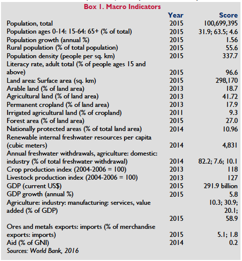
The Philippines had an estimated population of 100,699,395 in 2015, of which 44.4 percent is urban and 55.6 percent is rural. The country’s labor force is around 41 million people, or 61.3 percent of the total population age 15 and over, of whom 30 percent are employed in agriculture, 16 percent in industry, and 54 percent in services (World Bank 2016; CIA 2015).
Of the total land area, arable land constitutes 18.7 percent, with 17.9 percent in permanent crops. In 2012, there were 16,300 square kilometers of irrigated land. Approximately 45 percent of agricultural lands are moderately or severely eroded; approximately 27.3 percent of the country is vulnerable to drought, floods and typhoons. Land degradation exacerbates the effects of natural disasters, causing massive landslides and flooding (World Bank 2016; CIA 2015; GOP 2004c; GOP 2013d; Pulhin 2001)
LAND DISTRIBUTION
Land distribution is skewed. In the rural sector, there are an estimated 4.2 million small farms that average less than 1.5 hectares and 8,475 large private landholdings of up to 25,000 hectares. 89 percent of farm holdings are less than 3 hectares. There are 10.2 million marginal farmers and farm workers, 70 percent of whom are landless (Elauria, 2015). The number of informal settlements in rural areas is unknown. Since the 1930s, the State has instituted various land reforms, the most recent of which is the 1988 Comprehensive Agrarian Reform Law. While considerable swaths of land have been redistributed, the most contentious private agricultural lands, which are also the most productive and fertile, remain with wealthy private landowners (GOP (Philippines Statistics Authority) 2015; FAO 1997; Borras and Franco 2007; Quizon and Pagsanghan 2014).
Rural poverty and a high population growth rate have resulted in rapid urbanization. Of an estimated urban population of 44.1 million people, more than 9 million live in informal settlements (as of 2011). In Metro Manila, the largest urban center, approximately 25 percent of the population (584,000 households) lives on riverbanks, bridges, railroad easements, cemeteries, garbage dumps and idle lands. Typhoon Haiyan displaced thousands of people in 2013, many of whom remain in temporary housing of one sort or another (World Bank 2010a; GOP 2008e; Eleazar et al 2013; Hodal 2014;)
LEGAL FRAMEWORK
 Under the 1987 Constitution, all lands of the public domain belong to the State (Art. 12, Sec. 2). State ownership is premised on the Regalian Doctrine (jura regalia), the legal concept employed by the Spanish Crown in claiming exclusive dominion over the Philippine archipelago upon conquest in 1521. Under this doctrine, title to all lands became vested in the Crown, and private ownership was acquired only through royal grants or decrees. This was continued during United States’ (US) colonization, the Philippine Commonwealth period under the 1935 Constitution, and upon independence in the 1973 and 1987 Constitutions.
The Constitution classifies the public domain into agricultural, forest or timber, mineral lands or national parks (Art. 12, Sec. 3). Of these, only public agricultural lands are alienable (i.e., subject of private ownership) and further classified by law according to their use (Art. 12, Sec. 3). The State determines by law the size of alienable public lands as well as the specific limits of forest lands and national parks (Art. 12, Secs. 3–4). However, these laws have yet to be enacted, and the land classification under the 1936 Public Land Act remains in force. Under the Act, public domain lands are classified as either alienable or disposable (i.e., those open to acquisition and concession) or timber and mineral lands (Sec. 3). Alienable and disposable lands are classified according to their use as agricultural, residential, commercial, industrial, educational, charitable, or as reservations for public and quasi- public uses (Sec. 3). Presently, of the total land area, 14.19 million hectares (roughly 47 percent) are classified as alienable and disposable land, 9.67 million hectares remain devoted to agricultural use and 15.8 million hectares (roughly 53 percent) are forestland (GOP Constitution 1987a; GOP Public Land Act 1936; GOP 2008f, Cruz v. Secretary; GOP 2008a; GOP 2007a; Quizon and Pagsanghan 2014; GOP 2015d).
The 1987 Constitution also provides for: comprehensive land reform (Art. 2, Sec. 21; Art. 12, Secs. 1, 6, 8–10); recognition of indigenous communities and their customary rights to ancestral lands (Art. 2, Sec. 22; Art. 12, Sec. 5); creation of autonomous regions in the island of Mindanao and Cordillera provinces in the island of Luzon (Art. 10, Secs. 1, 15–20); and grant to natural-born citizens who have lost their citizenship the right to acquire private lands (Art. 12, Sec. 8). The provisions are reinforced in the Philippine Development Plan 2011–2016 and in the country’s commitment to the Sustainable Development Goals (GOP Constitution 1987a; GOP 2011).
The major land reform laws are the 1988 Comprehensive Agrarian Reform Law (CARL) and the 1992 Urban Development and Housing Act (UDHA). The CARL broadened the scope of rural land reform by including private and public agricultural lands regardless of crops and tenure arrangements, and providing for support services to agrarian reform beneficiaries, including infrastructure, capability-building and credit/marketing assistance. Lands were to be distributed to landless farmers and farm workers within a period of 10 years, but when this was not achieved, the law was extended for another 10 years, and then again extended until 2014 under the Comprehensive Agrarian Reform with Extended Reforms (CARPER) law. The 2014 deadline also was not met but President Aquino committed to completing the distribution by the end of his term in 2016. By the end of 2015 approximately 88 percent of such lands had been distributed. The UDHA established the legal framework for urban land reform and housing for informal settlers, slum dwellers and other underprivileged groups. Key provisions include the prohibition on summary evictions and demolition of dwellings without due process and adequate resettlement, and the provision of government loans to low-income households through the Community Mortgage Program (GOP Agrarian Reform Law 1988; GOP Urban Development and Housing Act 1992; GOP 2009; Quizon and Pagsanghan 2014; UN Habitat 2012; Eleazar et al 2013; GOP 2016).
The 1997 Indigenous Peoples’ Rights Act recognizes the right of indigenous peoples to their cultural integrity and self-government, and their customary property rights to ancestral domains and lands. The Act requires Free Prior and Informed Consent (FPIC) of indigenous peoples prior to any government grant of license or concession covering lands within ancestral domains. The 1989 Organic Act for the Autonomous Region in Muslim Mindanao provides for self-governance in Mindanao within the framework of national sovereignty.
Other relevant laws include: The Civil Code, which addresses general property/inheritance issues; the Family Code, which governs marital property rights; and various land titling and registration laws, including the Land Registration Act (1903), Cadastral Law Act (1913), Public Land Act (1936) and Property Registration Decree (1978).
A National Land Use Act bill has been pending in Congress for many years but has yet to be enacted into law. The bill aims to optimize the sustainable use, management, conservation and preservation of the land (Eleazar et al 2013; Quizon and Pagsanghan 2014).
TENURE TYPES
In the Philippines, lands are either public domain (state-owned) or privately owned. Under the 1987 Constitution, only public agricultural lands may be leased up to 1000 hectares to private corporations.
Citizens may lease up to 500 hectares or they may acquire by purchase, homestead or grant up to 12 hectares (GOP Constitution 1987a, Art. 12, Sec. 3).
The Public Land Act and other special laws grant land patents (e.g., homestead, sales or free patents) and concessions vesting ownership in individuals and private corporations upon fulfillment of certain requirements. Under the Comprehensive Agrarian Reform Program (CARP) and CARPER, farmer-beneficiaries are granted: 1) full or absolute ownership in the form of Emancipation Patents upon full payment of amortizations; or 2) non-absolute ownership in the form of Certificates of Land Transfer or Certificates of Land Ownership for those still completing payments. Stock ownership under the Stock Distribution Option is granted to agrarian reform beneficiaries in large corporate farms. Farm workers in areas within the retention limit of landowners and in private agricultural lands yet to be acquired by the government are granted leasehold rights with a 75:25 sharing in favor of the farmer-lessee.
Alienable and disposable lands (which include agricultural lands and reclassified lands) and privately owned lands (based on state grants or laws passed since colonization) are subject to: 1) purchase which vests ownership; or 2) lease which vests only the right to occupy and use for the period agreed upon. In 2003, 64.8 percent of lands classified as alienable and disposable were privately owned. Forest lands, including mineral lands and national parks, belong to the State subject to usufruct and resource utilization rights under certain conditions (Llanto 2003; GOP Constitution1987, Art. 12, Sec. 2).
Customary ownership rights over ancestral lands are recognized in the Constitution and Indigenous Peoples’ Rights Act. In addition, the Supreme Court, the highest civil court, has ruled that colonizers only acquired dominion over unoccupied or unclaimed portions of the Philippine archipelago, and ancestral lands are deemed private lands based on customary or native title outside the scope of the Regalian doctrine. Rural migration and population growth have led to the rise of informal settlements on public lands and idle private lands in urban and peri-urban areas. Informal settlers are protected under the Urban Development and Housing Act from summary evictions and demolitions (GOP 2008f, Cruz v. Secretary; GOP 2008d; Quizon and Pagsanghan 2014).
SECURING LAND RIGHTS
Land rights are acquired from the State by public grant or by operation of law, or from private transactions or contracts involving private lands. Public grants include: 1) land patents (homestead, sales or free patents) or leases conferred under special laws; 2) royal grants/decrees issued during the colonial period; 3) titles acquired under agrarian reform laws; 4) title acquired under the urban land reform law (which grants the urban poor the right to purchase home plots in their existing settlements or resettlement areas); and 5) title in the form of Certificates of Ancestral Domain Claim (CADC) and Certificates of Ancestral Land Claims (CALC) acquired by indigenous peoples under the Indigenous Peoples‘ Rights Act (GOP Civil Code 1949, Book II; GOP Indigenous Peoples‘ Rights Act 1997; GOP 2010 (New Residential Free Patent Act of 2010); Quizon and Pagsanghan 2014).
Land rights are acquired by operation of law through accretion, prescription, hereditary succession or inheritance, or marriage under the property regime of absolute community of property (i.e., joint ownership of property brought into the marriage or acquired after). For private lands, rights may be acquired through voluntary transactions such as sales and donations, transfer by will, or involuntary transfer such as foreclosure or tax sales. These transactions are governed by general property and commercial laws (GOP Civil Code 1949, Books II and III; GOP Family Code 1987b, Tit. 5 Ch. 3).
The 1987 Constitution restricts access to public lands. Citizens may acquire public lands of not more than 12 hectares by purchase or land patent, or of no more than 500 hectares by lease. Private corporations must be at least 60 percent Filipino-owned and may lease land of not more than 1000 hectares for a period of 25 years, renewable for the same term. The use of public and private land is subject to zoning or local land-use classification laws. Foreigners may acquire private land only in limited circumstances (GOP Constitution 1987a, Art. 12, Sec. 3; Galacio 2008; Quizon and Pagsanghan 2014).
The Land Registration Act requires registration of land rights under the Torrens system. Under this system, the government issues a certificate of title (Torrens title) as proof of ownership; it is the highest measure of tenure security. Courts have upheld ownership based on tax declarations, realty tax receipts and transfer deeds. Land rights are secure insofar as they may be proved or traced back to some State grant or lawful private transaction (Eleazar 2013; Malenab-Hornilla 2008).
An inefficient land administration system, exacerbated by the lack of a national land use planning law, contributes to tenure insecurity and high transaction costs in securing, registering and transferring property rights. Overall, the land information system is inadequate. It takes between six months to several years to obtain original titles and an average of 35 days to register subsequent transactions. An estimated 11 million parcels are untitled. This is exacerbated by overlapping mandates of institutions involved in the administration and regularization of property and land (Llanto and Ballesteros 2003; World Bank 2016a; Oxfam 2014; Quizon and Pagsanghan 2014; Eleazar et al 2013).
URBAN TENURE
The Philippines is rapidly urbanizing, mostly because of rural poverty and a high population growth rate. In Metro Manila, nearly 25 percent of the population lives on various public lands, infrastructure or idle lands. As of 2011, approximately 20 percent of the estimated urban population of 44.1 million people, lived in informal settlements. Typhoon Haiyan displaced thousands more in 2013. (World Bank 2010a; GOP 2008e; Eleazar et al 2013; Hodal 2014).
Rural-to-urban migration and lack of access to land and housing by the poor have led to swelling squatter colonies or informal settlements on public and privately-owned lands in urban and peri-urban areas. Mass evictions have often resulted in violent confrontations between the squatters and the government or private landowners (Borras and Franco 2007; GOP 2006a; Villanueva 2007; Eleazar et al 2013; Quizon and Pagsanghan 2014; USAID 2014a).
Secure urban tenure is undermined by several factors: 1) Several organizations have overlapping mandates for the regularization of key processes in land administration including property registration, surveying functions, titling, planning and property taxation. This can result in the issuance of multiple titles to the same parcel, a circumstance that also occurs due to the parallel registration of titles through judicial and administrative processes; 2) Local Government Units capacity to support land use planning and zoning administration is limited and they operate ineffectively. Limited technical capacity of LGU staff to collect, analyze and integrate data for improved land use planning is an important limitation to land use plan development in the Philippines. Moreover, lack of planning coordination between LGUs has resulted in conflicting planning objectives and inefficient urban design; and 3) Only about half of all parcels in the Philippines are formally registered in the Torrens Title System. This is due in large part to lengthy delays in completing the process and high costs of registering property. These high costs for registration serve as a disincentive for formalization of rights and result in fewer properties being registered within the title system (USAID 2014a).
INTRA-HOUSEHOLD RIGHTS TO LAND AND GENDER DIFFERENCES
The law generally provides for equal land access. Under property law and under family and succession law, men and women have equal property rights. Assets acquired during cohabitation without marriage are co-owned, and can be encumbered or disposed of by one partner only with the consent of the other. Within marriage, the property regime is absolute community of property – unless a different regime is stipulated in the marriage settlements – and both spouses jointly administer family property (GOP Family Code 1987b, Arts. 147, 75, 96).
In case of disagreement, the husband’s decision prevails, subject to recourse to the courts by the wife. The wife retains sole management rights to her exclusive property. In case of legal separation, the terms of dissolution of community property are determined by guilt, not by gender (GOP Family Code 1987b, Arts. 96, 111, 63[2]).
Married women may make wills without the consent of their husband, and dispose of their separate property and share of community property. Widows are compulsory heirs of their deceased spouses (GOP Civil Code 1949, Arts. 802–3, 900; Cotula 2007).
 The Women in Development and Nation Building Act (1992) expressly grants women, regardless of civil status, the same capacity to act and enter into contracts as men, and equal treatment in agrarian reform and land resettlement programs. The Comprehensive Agrarian Reform Law guarantees women, regardless of civil status, equal rights to own land, equal shares of farm produce, and representation in advisory and decision-making bodies. The Magna Carta of Women (2009) grants equal property and inheritance rights to wives and common law spouses, and equal access to agrarian and customary lands (GOP Agrarian Reform Law 1988, Sec. 40 [5]; GOP Magna Carta of Women 2009b, Secs. 19–20)
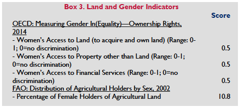
However, despite these laws, patriarchal attitudes and deep-rooted stereotypes regarding the role of women persist (The OECD rankings [see Box 3] are based simply on the question of whether women can own land and property, as indeed they can). In practice, men are still the primary property owners, and some laws and government policies that are neutral on their face to discriminate against women when implemented, although this situation is changing to some extent pursuant to the Land Administration and Management Project (LAMP) Phase 2 described in the Donor Interventions section. The order of priority of agrarian beneficiaries under the Agrarian Reform Law disadvantages women, as they are mostly seasonal farm workers and thus rank third in priority of distribution. Government-sponsored indigenous peoples’ resettlement projects award land titles and certificates of titles to crops to the head of the family, who is often a man. Although women have the legal right to independently enter into contracts, many financial institutions require the husband or male partner to co-sign loans and financial contracts; women’s access to credit is limited to smaller amounts as they usually have less property to provide as collateral. Moreover, the land information system does not collect gender disaggregated data, thus permitting little meaningful monitoring of the extent to which women own or have secure rights to land (GOP Agrarian Reform Law 1988, Sec. 22; Cotula 2007; Tripon 2008; OECD 2014; Eleazar et al 2013; Corral 2015).
Customary laws practiced in rural areas and by various ethnic groups generally grant men greater access to land than women. Tribes in the north and center of the country give women equal right to land ownership, but it is the men who principally administer and manage conjugal properties. Southern Muslim tribes require the husband’s consent before a woman may acquire any property, and women inherit only half the share inherited by men in a similar position (Cotula 2007; OECD 2014).
LAND ADMINISTRATION AND INSTITUTIONS
There are many government agencies that are involved in land administration and management. The Department of Agrarian Reform is the lead agency for agrarian reform. Its functions include: land surveys; processing of compensation; registration of lands; and issuance of certificates of ownership. The Department coordinates with the Department of Environment and Natural Resources (DENR) for land survey and distribution, and with the Department of Agriculture for delivery of support services (Llanto and Ballesteros 2003; Eleazar et al 2013).
The Housing and Urban Development Coordinating Council is the highest policy-making and coordination agency on urban development. It coordinates with the Housing and Land Use Regulatory Board for the review of cities and municipalities’ development plans, zoning, and settling land-use conflicts; and the National Housing Authority for urban resettlement. Other key land agencies are: 1) the Land Management Bureau (under DENR), which recommends policies/programs for the administration of alienable and disposable lands; 2) the Land Registration Authority (LRA), which issues patents and certificates of title and registers land-transaction documents (a Registry of Deeds is attached to the Land Registration Authority in every city and province); 3) the National Commission on Indigenous Peoples (NCIP), which assists indigenous peoples in securing title to their lands and approves any proposed disposal, utilization, management or appropriation of ancestral lands; and 4) Local Government Units, which develop land-use and development plans and zoning ordinances.
The Bureau of Fisheries and Aquatic Resources, a part of the Department of Agriculture, is charged with ensuring that fisherfolk have safe and secure settlements near their fishing grounds. A large percentage of fisherfolk reside in informal settlements and are in danger of eviction (Calvan 2015).
Many regulatory agencies, including Local Government Units, in the Philippines have limited capacities to implement and enforce land, environment and natural resource laws and to protect property rights. In addition, there are also problems of overlapping responsibilities and duplicative documentation. For example, both DENR and LRA approve subdivision plans but they do not share their records. DAR, DENR, LRA and NCIP all issue titles but do not necessarily share information with the other agencies. This has resulted in duplicate titles, conflicting claims and many disputes (Eleazar, et al 2013).
LAND MARKETS AND INVESTMENTS
There is an unmet demand for housing, commercial and industrial land. The Philippines Development Plan 2011–2016 projects a need for 5.8 million housing units by 2016. The government aimed to provide nearly 1.5 million units during the 5-year PDP. Developers have contended that this can only be met by converting tracts of farmland on the outskirts of urban areas and the government appears to have rescinded a 2008 ban on agricultural land conversions in 2008 due to food security concerns. But CARP continues to establish significant legal limits on such conversions (PDI 2008a; PDI 2008b; GOP 2011 (PDP)).
Buying, selling, renting and mortgaging of land are governed by general property and commercial laws. Certain lands acquired by public grants and under agrarian reform laws, such as land patents, emancipation patents or certificates of land ownership awards, contain restrictions on transfers and mortgage. This has resulted in informal markets of prohibited land transactions. There are multiple land valuation systems and they lack transparency and standardization, resulting in different pricings for the same property. Various government agencies use different bases for valuation, such as market valuation by zone or area for taxation purposes – which can vary between national and local authorities, and valuation according to use for land conversion or development purposes. The zonal valuation system, especially in rural provinces, is outdated, resulting in undervaluation of properties (Lanto and Ballesteros 2003; Domingo and Fulleros 2005; Quizon and Pagsanghan 2014).
There is a lack of reliable data on property markets. Actual land sales prices are not publicly available. Land record systems are unsystematic and unreliable as to land ownership, locations, boundaries, actual land uses and land values. Many records have been destroyed by war, theft, fire and water damage, or have been misplaced. Many records are in fragile condition, and some have been illegally altered. There is no complete set of cadastral maps that shows titled and untitled properties on alienable and disposable lands. The titling system lacks quality control – multiple titles and gaps in titles are not easily detected. Inefficiencies combined with high land taxes have led to informal land markets, particularly in poor communities (Llanto and Ballesteros 2003; Quizon and Pagsanghan 2014).
COMPULSORY ACQUISITION OF PRIVATE PROPERTY RIGHTS BY GOVERNMENT
Expropriation is an inherent power of the State. The authority is lodged with the Philippine Congress but delegated under various laws to national government agencies, local government units and public utilities involved in infrastructure development (GOP 2008f, Moday v. Court of Appeals).
The grounds and procedures for expropriation are set forth in the 1987 Constitution and enabling legislation. Private property cannot be expropriated without due process and just compensation. The taking must be for public use, interpreted broadly by the courts to be consistent with public welfare or public exigency. Just compensation is defined as the full and fair equivalent of the property, based on the owner’s loss at the time of the taking, and is a judicial function. The Comprehensive Agrarian Reform Law and Urban Development and Housing Act involve large-scale exercises of expropriation. In general, expropriation processes, including payment of compensation and resettlement, are applied inconsistently, especially in the case of projects that are not supported by foreign donors (GOP Constitution 1987a, Art. 3, Secs. 1, 9; GOP 2008f, Manosca v. Court of Appeals, National Power Corporation v. Bagui; Quizon and Pagsanghan 2014; Eleazar et al 2013).
The Indigenous Peoples Rights Act of 1997 provides that indigenous peoples may not be relocated from their land except through eminent domain. In such cases, those who are relocated are entitled to receive land of at least equal quality as well as compensation “for any resulting loss or injury” (GOP 1997.)
LAND DISPUTES AND CONFLICT
Unequal access to land and resources is a key driver of conflict, fueling social unrest and armed uprisings. There have been various land reform programs since the 1930s, but none have been effectively implemented. The latest comprehensive agrarian reform program remains uncompleted more than 25 years after it was launched in 1988, and the most productive and fertile lands are still in the hands of private plantation and commercial farm owners. However, in the face of on-going budgetary constraints and bureaucratic inefficiencies, the government has shown increasing political will to complete the agrarian reform program. For those who have benefited from land distribution, slow delivery of support services and infrastructure promised under the program has resulted in sub-optimal use of the land, although more recently the government has more aggressively attempted to provide support services to beneficiaries. Rural-to-urban migration and lack of access to land and housing by the poor have led to swelling squatter colonies or informal settlements on public and privately-owned lands in urban and peri-urban areas. Mass evictions have often resulted in violent confrontations between the squatters and the government or private landowners (Borras and Franco 2007; GOP 2006a; Villanueva 2007; Eleazar et al 2013; Quizon and Pagsanghan 2014).
Conflicts related to large-scale land acquisitions are relatively frequent. These conflicts often involve inadequate or unpaid compensation or unmitigated social and environmental consequences of the investment. In some cases, land rights of indigenous peoples are undermined by investor failure to obtain free, prior and informed consent of the affected population (Eleazar et al 2013).
Indigenous peoples are marginalized and have been pushed out of their ancestral lands by the government for infrastructure projects, and by private farming interests and natural resource concession holders. They struggle to uphold their rights under the Indigenous Peoples’ Rights Act, which conflicts with the Regalian doctrine applied in various laws. Disputes have arisen where the boundaries of indigenous lands overlap with lands claimed by others and due to overlapping government agency mandates. The mapping of indigenous lands (through the issuance of Certificates of Ancestral Domain Title) remains incomplete, posing an additional threat to the rights of indigenous peoples (e.g., 1995 Mining Act, 1992 National Integrated Protected Areas System Act and Revised Forestry Code; Novellino 2000; Quizon and Pagsanghan 2014; Eleazar et al 2013).
In 2012 the government signed a framework peace agreement with the Moro Islamic Liberation Front, one of the groups of Muslim separatists that have engaged in armed rebellion in Mindanao, where six of the country’s 10 poorest provinces are located, since the late 19th Century. This was followed by a comprehensive agreement in 2014. The agreement provides for the establishment of an autonomous entity called Bangsamoro covering a larger land area than the autonomous Mindanao region. Importantly, the separatist Moro National Liberation Front is not a party to the agreement. Implementing legislation has yet to be adopted and there are questions about the constitutionality of the agreement. Violent conflict and instability persist. The conflict dynamic is further complicated by the activities of the Abu Sayyaf Group, considered a terrorist group by the government with links to Jemaah Islamiya, the Indonesia-based Al-Qaeda affiliate. The region is also plagued by localized clan rivalries over land and resources and political dominance (Gutierrez 2008; Kamlian 2003; USAID 2010a; Knack 2014; Thompson Reuters 2014; International Crisis Group 2015).
Except in areas covered by the LAMP project, outdated land administration laws, an inefficient land administration infrastructure and a poor land information system continue to result in widespread problems of fraudulent, overlapping and duplicative land titles, and have contributed to land-grabbing and frustrated efforts to resolve long-standing land disputes. Inconsistent legislation and policy declarations have led to unsustainable land use and conflict over competing land uses. Large swathes of productive agricultural land, especially in the rice bowl provinces in central Luzon, have been converted for housing, commercial and industrial purposes (Eleazar et al 2013; Llanto and Ballesteros 2003; Kelly 1998; Quizon and Pagsanghan 2014; World Bank 2014).
Typhoon Haiyan caused or worsened land disputes in the areas affected by the storm. Loss of land documents, the lack of a coherent land use policy, insufficient land for relocation and displacement due to land conversions have been devastating to the most vulnerable people affected by the typhoon (Oxfam 2014).
KEY LAND ISSUES AND GOVERNMENT INTERVENTIONS
As in many developing countries with natural resource-based economies, land and natural assets are highly politicized in the Philippines. Control over land and resources is often a major strategy for maintaining political control; traditional politics are oriented toward maintaining elite control over the nation’s land and other resources. This has created a dualistic economy, where the welfare of the elite and the poor majority are often in opposition. In this context, economic growth can reinforce inequity rather than reduce it. A central problem, then, is the political economy which perpetuates control of some economic assets (land, resources) and political power by a small grouping of wealthy families. These problems are intimately tied to those of disappearing natural resources and continuing widespread poverty and inequity (Gollin and Kho 2002).
Under the Philippines Development Plan (PDP) 2011-16, there is an emphasis on improving basic infrastructure and governance in pursuit of the goal of achieving inclusive growth. The PDP seeks to accelerate and complete the agrarian reform program and resolve other property rights issues involving agricultural land. As of the end of 2015, the government had distributed over 4.7 million hectares to CARP beneficiaries since the beginning of the program, about 88 percent of its target. The CARPER law provides for delivery of an integrated package of support services to existing and new agrarian reform beneficiaries. It is also continuing asset reforms in urban and ancestral lands. Recent interventions on urban land reform include: 1) passage of the Residential Free Patent Act of 2010 which facilitates the conversion of public alienable and disposable land into registered residential lands; and 2) the Social Housing Finance Corporation is providing microfinancing for the bottom 30 percent of the population under the Community Mortgage Program. The program enables borrowers to obtain housing; it had nearly 22,000 beneficiaries in 2014. The PDP includes a goal of providing nearly 1.5 million housing units nationwide by 2016; about 300,000 had been provided as of July 2013 (GOP 2009 (CARPER law); GOP 2011; GOP 2015a; GOP 2014; Eleazar et al 2013; SHFC 2014; GOP 2016).
The Philippines is highly vulnerable to climate change and natural disasters, as demonstrated by the devastation wrought by Typhoons Ketsana and Parma in 2009, Washi in 2011, Bopha in 2012, Haiyan in 2013 and Ruby, Amang and Seniang in 2014 and 2015. The government’s goal of increasing resilience to climate change includes efforts to improve land administration and management. The National Climate Change Action Plan calls for enacting a comprehensive land use law (GOP 2011; GOP 2011a).
In late 2008, the government declared an indefinite moratorium on the conversion of prime agricultural lands. In August 2009, Congress extended the implementation of the Comprehensive Agrarian Reform Law until 2014.
The government is promoting area-based clustering of farms to improve the delivery of agrarian support services (GOP 2009; PDI 2008a; GOP 2006a).
A Lands Sector Development Framework was developed in 2012. It serves as the country’s blueprint for land administration and management reforms. The second phase of the government’s Land Administration and Management Project aims to improve tenure security, create an efficient land market and improve public confidence in the land administration system. Project initiatives include: the creation of a more efficient land-records system, and more equitable and uniform property valuation system; the rationalization and streamlining of land administration agencies; and the improvement of accessibility to land registry records. The central government has also attempted to assist Local Government Units to better manage their land administration and land use responsibilities. An ongoing effort to enact a new National Land Use Act has been unsuccessful (Eleazar, et al, 2013; GOP 2008c; GOP 2014 Quizon and Pagsanghan 2014).
DONOR INTERVENTIONS
USAID provides support for the Philippines in part pursuant to the Partnership for Growth.2 The program seeks to address the country’s most serious constraints to inclusive and lasting growth. USAID’s Country Development Cooperation Strategy Philippines 2012–2016 includes programs for inclusive economic growth acceleration, peace and stability in Mindanao (in part through a program that addresses and seeks to reconcile land-related conflicts), and improving environmental resilience and humanitarian assistance in the wake of Typhoon Haiyan. USAID is supporting a variety of disaster risk reduction and climate change adaptation initiatives as the government goes about implementing the Disaster Risk Reduction and Management Act of 2010 and the Climate Change Act of 2009. At the national level, USAID is investing in improved property rights and land use through a new project called Strengthening Urban Resilience for Growth with Equity, aimed at promoting inclusive economic growth and resilience outside the Metro Manila area, including securing property rights. Broader USAID support for good governance also supports the Mission’s sector work. (USAID; USAID 2012; USAID 2015).
The World Bank Country Partnership Strategy for the Philippines 2015–2018 continues to focus on inclusive growth for the poor in line with the government’s PDP. Projects include: 1) the recently concluded second phase of the Land Administration and Management Project, in collaboration with the Australian Department of Foreign Affairs; and 2) continued support for the Participatory Irrigation Development Project, aimed at improving irrigation service delivery and increasing agricultural production. Recently, the Bank conducted an assessment of land governance on Mindanao as part of the Mindanao Jobs Report – citing the weak property rights as a key constraint to developing more and better jobs in Mindanao. The Bank also published a policy paper on affordable housing in the Philippines which, among other things, addresses the tenure insecurities of informal settlement families. This issues was discussed at a National Housing Summit held in 2016 (World Bank 2014; World Bank 2016b; World Bank 2016c).
The Asian Development Bank Country Partnership Strategy for the Philippines 2011–2016 includes investments in: 1) improved sustainable land-based natural resource management; and 2) supporting the Comprehensive Agreement on Bangsamoro by providing financial assistance for the Bangsamoro Development Plan. The 2016-2018 Country Operations Business Plan projects 1) assistance inclusive agri-industry marketing and trade; 2) sustainable and climate resilient infrastructure; and 3) urban infrastructure (ADB 2011; ADB 2015; ADB 2015a).
The FAO supported a multi-sectoral study on the Agribusiness Venture Arrangements (AVA) policy and implementation under CARP. The objective was to identify gaps in the program and make recommendations on how those arrangements can be improved so as to increase productivity and income of farmer organizations, smallholder farmers and laborers and to increase profitability of private sector investments in AVAs. The FAO is also providing technical support to implement the 2012 Voluntary Guidelines on the Responsible Governance of Tenure of Land, Fisheries and Forests. It is also supporting the Land Management Bureau in connection with the Lands Sector Development Framework (FAO 2015; FAO 2016).
The Japan International Cooperation Agency (JICA) has supported agricultural infrastructure projects (including irrigation facilities, roads and bridges) in connection with the Agrarian Reform Infrastructure Support Project being implemented by DAR. JICA also continued its support for peace building in Mindanao (JICA 2013; JICA 2014; Torres 2015).
Many Philippine NGOs are engaged in land matters – from political activism to serving as intermediaries between citizens and the State. Many of these NGOs work to strengthen community groups by providing financing, advocacy and capacity-building.
Freshwater (Lakes, Rivers, Groundwater)
RESOURCE QUANTITY, QUALITY, USE AND DISTRIBUTION
The Philippines has extensive water resources, including 31,000 hectares of rivers; 200,000 hectares of lakes; 19,000 hectares of reservoirs; and more than 100,000 hectares of wetlands. There are 421 river basins, of which 20 are considered major river basins. Major rivers are the Cagayan – the country’s longest river – the Agno, Pampanga, Pasig and Bicol rivers in Luzon, and the Rio Grande de Mindanao. There are 59 significant lakes; 16 lakes cover 400 hectares or more. The largest lakes are the Laguna de Bay on Luzon and Lake Lanao on Mindanao.
Philippine rivers and lakes are home to more than 316 fish species, some of which are endemic (Philippine coastal waters are considered the center of marine biodiversity in the world). Groundwater reservoirs have a storage capacity of 251,100 million cubic meters and a dependable supply of 180,000 million cubic meters per year. Total renewable water resources equal 479 cubic kilometers. Average annual rainfall is 2348 millimeters (FAO 2005c; GOP 2006c; Gamolo 2008; GOP 2009a; NWRB 2006e; UN Water 2013; FAO 2011; CIA 2015).
The largest share of total water withdrawal is for agriculture, with irrigation, livestock, and fisheries representing 82 percent of total water use, while industry and domestic sectors share the rest. 96 percent of total water withdrawals are from surface water with 4 percent from groundwater. Groundwater use is reserved primarily for domestic drinking purposes and is distributed as: 63 percent for domestic use; 17 percent for industry; 13 percent for agriculture; 1 percent for power generation; and 6 percent for other sectors. Many people fish for home consumption or small-scale commercial activities. 3.4 percent of the workforce were employed in the fishing industry in 2014. Ten major lakes are used for aquaculture production (Gamolo 2008; FAO Aquastat 2011; WAVES 2015).
Water supplies are generally sufficient for local needs but there are water deficits in highly populated areas, particularly in regions with limited supplies. Only 43 percent of the population has access to piped water into private premises although the figure drops to 25 percent in rural areas. And water quality is worsening. The discharge of municipal and industrial wastewater and agricultural runoff has caused extensive pollution. Only 10 percent of municipal wastewater undergoes secondary or tertiary treatment. Experts have concluded that 50 river systems are biologically dead or dying due to pollution from human trash, commercial agricultural chemicals, untreated raw sewage, animal wastes and industrial wastes. Fewer than 4 percent of urban households have access to sewerage systems. In Metro Manila, nine river sub-basins are used as dump sites. One-third of the country’s river systems remain as potential sources of drinking water. Up to 58 percent of groundwater is contaminated due to leaching of industrial, agrochemical and animal wastes and infiltration of subsurface discharges from septic systems and polluted urban runoffs. Over-extraction of groundwater has led to a decline in levels, drying up of wells and springs, and contamination of wells by saltwater intrusion in coastal areas. Over-exploitation of forest resources and inappropriate land-use practices have disrupted the hydrological condition of watersheds, resulting in accelerated soil erosion, siltation of rivers and valuable reservoirs, increased incidence and severity of flooding and decreasing water supply. Groundwater, the source of most drinking water, is projected to be inadequate to meet the demand in major cities by 2025. Without new investment in water supply infrastructure, future projections of water requirements suggest that water availability will be marginal or unsatisfactory in eight of the 19 major river basins before 2025, and most major urban centers will experience water deficits (Alikpala 2008; GOP 2006c; Greenpeace 2010; GOP 2011; FAO 2011; UN Water 2013; WAVES 2015).
Climate change is projected to have a significant impact on the Philippines. Water availability and management is likely to become more challenging over time due to as the severity of both droughts and deluges is expected to heighten (ADB 2013).
LEGAL FRAMEWORK
Under the 1987 Constitution, all waters and aquatic resources belong to the State; the measure and limit of water use for irrigation, water supply, fisheries or industry is beneficial use, and water use for power generation is allowed for 25 years, renewable for the same term. Other policy guidelines are set forth in the Philippine Development Plan 2011–2016. Key targets of the Philippines Development Plan include: (1) increasing to 87 percent the percentage of the population with access to potable water; (2) the reforestation of 1 million hectares of land in 140 priority watersheds; (3) eliminating all waterless areas; and (4) reducing water pollution in priority water body areas. The Constitution gives subsistence fisherfolk preferential rights to inland and offshore communal fishing resources (GOP Constitution 1987a, Art. 7, Sec. 2 and Art. 8, Sec. 7; GOP 2011).
The 2004 Clean Water Act aims to protect the country’s water bodies from land-based pollution sources and to establish a framework for water-quality management. The 1976 Philippine Water Code defines the extent of the rights and obligations of water users. The 1998 Philippine Fisheries Code, as amended in 2015 under Republic Act 10654, provides for the sustainable development of fishery and aquatic resources and the structure for the granting of fishing privileges. The 2015 amendments seek to meet European Union sustainable fishing requirements by adding harvest control mechanisms and cracking down on illegal fishing through higher penalties for commercial fishing violations and poaching. The 1997 Agriculture and Fisheries Modernization Act provides for measures to modernize the agriculture and fisheries sectors. Two other laws affecting fisheries management are the 1992 National Integrated and Protected Areas System Act (NIPAS) and the 1997 Agriculture and Fisheries Modernization Act (AFMA). (Palawan State University 2011; GOP 2015b (Republic Act No. 10654)).
WATER TENURE ISSUES
Under the Water Code, a water permit is required for non-domestic use: irrigation, community use, commercial uses (e.g., power generation and fisheries), industrial use and recreational use. No permit is needed for household uses and collecting of water using hand-carried receptacles; washing, watering or dipping of domestic or farm animals; or boating or water transportation. The Indigenous Peoples’ Rights Act recognizes indigenous peoples’ customary rights over all natural resources within ancestral domains, and designates them as administrators of watersheds within their domains (GOP 1997 (Indigenous Peoples’ Rights Act)).
Increased water demand from population growth, urbanization and industrialization cannot be met by the current water infrastructure. Inefficient water use has led to considerable wastage of water in distribution lines, irrigation canals and in homes. While water is not yet in short supply the resource faces stresses caused by increased demand, pollution and climate change. (EC 2005; Barba 2004; ADB 2013; FAO 2011).
MARINE TENURE ISSUES
Under the Constitution, subsistence fisherfolk have preferential rights to inland and offshore communal fishing resources. Fishing rights are granted by Local Government Units within their municipal waters (up to 15 kilometers from the coastlines under the Fisheries Code) or special agencies created by law to administer select bodies of water (e.g., Laguna Lake Development Authority, Palawan Council for Sustainable Development). Priority fishing rights are granted to municipal fisherfolk and their organizations listed in the registry of municipal fisherfolk, subject to certain conditions and limitations. Fishpond licenses are required under the Fisheries Code, with preference given to small or medium enterprises, for up to 50 hectares for individuals and 250 hectares for associations/enterprises, subject to certain conditions. LGUs have the primary responsibility for supporting and enforcing preferential rights for small scale fisheries. The Department of Agriculture’s Bureau of Fisheries and Aquatic Resources governs fishing in national waters and the Exclusive Economic Zone. (GOP Constitution 1987a, Art. 7, Sec. 2 and Art. 8, Sec. 7; GOP 2011; Palawan State University 2011; USAID 2016b).
Women are relied upon to provide water for household needs while men make many of the decisions about water resource management and development. Women are involved in pre- and post-harvest fishing activities, such as fish processing and marketing, mending nets and tending fishing equipment. In 2009, female employment in the fishery sector was 9 percent, less than 1 percent of the country’s aggregate female labor force, compared to male fisheries employment of 6.3 percent of the aggregate male labor force. But one study found that women constitute 42 percent of all fishers in the central Philippines, suggesting that female participation in the industry may be significantly undercounted (FAO 2005a; ADB 2004a; GOP 2010b; Kleiber 2014).
In practice, small scale fisherfolk have insecure tenure over fisheries resources because current law and practice does not adequately define and secure the full bundle of fisheries tenure rights, including exclusion, withdrawal/access, management, enforcement, and alienation rights. The capacity of national and local tenure governance bodies to secure these rights can be should be improved by: strengthening the role of local resource users in decision-making; supporting more effective co-management arrangements and dispute resolution mechanisms; and providing the administrative, legislative, and other mechanisms to recognize tenure rights (USAID 2016b).
GOVERNMENT REFORMS, INTERVENTIONS, AND INVESTMENTS
The government’s water-related programs are guided by the Philippines Water Supply Sector Roadmap (PWSSR), the overall goal of which is providing safe water for all, and the Philippines Development Plan. The PWSSR has embraced the Philippine Integrated Water Resources Management Plan, which aims to integrate land and water resources (surface, groundwater and coastal); coordinate all water-related efforts based on a participatory approach that includes users; promote equitable access to water supply; restore the health of critical ecosystems; and promote environmental sustainability. Other interventions include: development and implementation of a national integrated coastal management program; revising policies and practices to protect and manage mangroves, sea grasses, coral reefs, and beaches; safeguarding coastal ecosystems, species, and genetic diversity by improving the status of coastal and marine biodiversity; and, a program to complete the delineation of municipal waters (ADB 2013; GOP 2010a; Palawan State University 2011; GOP 2011).
DONOR INTERVENTION AND INVESTMENTS
USAID chairs the sub‐working groups on water supply and sanitation under the Philippines Development Forum. Specific investments include: 1) providing support for government programs that address continuing degradation of forests and watersheds; 2) working with local governments in conflict-affected areas of Mindanao to improve water and energy services; 3) providing water assistance to victims of Typhoon Haiyan; 4) the Abuan Integrated Watershed Management Program and Agusan Marsh Climate Change Adaptation Project, both of which will help farmers adapt to climate change; 5) the Philippines Biodiversity and Watersheds Improved for Stronger Economy and Ecosystem Resilience program; and the Ecosystems Improved for Sustainable Fisheries (ECOFISH) project, which aims to conserve marine biodiversity, enhance ecosystem productivity and improve fisheries and related livelihoods in eight areas of the Philippines; among others. (USAID 2014; USAID 2015a; USAID 2016; USAID 2016a).
Active World Bank investments include: 1) the Metro Manila Wastewater Management project and the Water Resources Development Program for rehabilitation of critical watersheds; 2) the Comprehensive and Integrated Delivery of Social Services Project aimed at improving water quality, sanitation and flood protection; 3) the Improved Access to Water Services in Metro Manila Project for increased access to piped water supply services for poor households; 4) the Philippine Rural Development Program Support to support institutional reforms that will raise rural incomes and increase the competitiveness of the fisheries and agricultural sectors; 5) the Global Environment Facility-Manila Third Sewerage Project to promote capacity building and effective wastewater treatment techniques; and 6) a project designed to reduce flooding in Metro Manila (World Bank 2010c; World Bank 2010d; World Bank 2014; World Bank 2013; World Bank 2014a; World Bank 2015a).
The Asian Development Bank (ADB) invests in: 1) the Metro Manila Water and Sanitation Development Project development of new water sources under the Water District Development Sector Project; 2) river-basin management under the Pasig River Environmental Management and Rehabilitation Project; 3) the Angat Water Transmission Improvement Project; and (4) the Water District Development Sector Project (ADB 2014; ADB 2015a; ADB 2015b).
Trees and Forests
RESOURCE QUANTITY, QUALITY, USE AND DISTRIBUTION
Philippines forest cover is estimated at 6.8 million hectares or 23 percent of total land area3 of which around 12 percent is dipterocarp or lowland rainforest, 3.5 percent mossy/montane or cloud forest, 0.4 percent coastal and mangrove forest, 0.77 percent pine forest and 1.6 percent sub-marginal forest, with patches of beach forests and the emergence of a new forest type – the peat swamp forest or peat dome found in Agusan del Sur. The largest remaining forest patches are found in northern and southern Luzon (especially the Sierra Madre mountain range, Palawan, Mindanao and eastern Visayas). Old-growth or primary forest comprise around 861,000 hectares. Based on use, production forest comprises 76 percent; protection forest4 comprises 8 percent5; and conservation forest6 comprises 16 percent of total forest area. 10.28 percent of forest land (0.737 million hectares) are within lands classified as alienable and disposable (GOP 2009a; FAO 2010; GOP 2014a; WB 2015; Senate of the Philippines 2015).
In 1917, forest cover was 17 million hectares, or more than 50 percent of the country’s land area compared to 6.8 million hectares today. The current deforestation rate is around 2.1 percent per year, representing a significant drop from the 1990’s rate, but still the second-highest rate in Southeast Asia (after Myanmar). The main direct cause of forest degradation in the Philippines is over-exploitation from logging, fueled by weak governance, the capture of resources by elite groups, failure to collect rents from licensees, short-sighted and unpredictable policies, rapid population growth and increased conversion of forest land to agricultural, residential and commercial uses. Additional threats come from mining operations, collection of fuelwood, and poor management by the government and tenured stakeholders. Deforestation effects include: the extinction or near extinction of endemic species (e.g., Philippine tamaraw or wild buffalo, Philippine eagle); loss of valuable topsoil; landslides and silted streams; and destruction of coastal mangroves (FAO 2005b; Guiang and Castillo 2006; Chokkalingam et al. 2006; FAO 2010; GOP 2009a; PTFCF 2015).
LEGAL FRAMEWORK
Under the 1987 Constitution all forest lands and natural resources belong to the State (Art. 7, Sec. 2). Major forestry laws include: 1) the 1975 Revised Forestry Code, which governs the use and management of forest lands and products; 2) the 1981 Environmental Impact Statement System law, which requires environmental impact assessments and Environmental Compliance Certificates for projects in critical areas; 3) the 1992 National Integrated Protected Areas System Act, providing for the establishment of a comprehensive system of protected areas; 4) the 1997 Indigenous People‘s Rights Act, which recognizes the customary right of indigenous peoples to forest resources within their ancestral domains and their right to participate in forest programs; 5) the 2001 Wildlife Resources Conservation and Protection Act, which protects wildlife resources and habitat, and regulates the collection and trade of wildlife; and, 6) the 2002 Chainsaw Act, which regulates ownership, sale and use of chainsaws to prevent their use for illegal logging and clearing of forest land. Forest policy is guided by the concept of Sustainable Forest Management, recognized in the Philippine Agenda 21, Millennium Development Goals and Philippine Development Plan 2011–2016 (GOP 1996; GOP 2011).
A large number of laws and implementing regulations developed since 1980 directly support community- based forest management (CBFM). These were developed in direct response to the rapid deforestation experienced in during years of martial law. Executive Order No. 263 of 1995 issued from the President’s Office is of particular importance to communities and forests. The Order pronounces CBFM as a strategy for forest management and provides mechanisms for its implementation, “entrusting the responsibility for forest rehabilitation, protection, and conservation to the community of stakeholders and affording them equitable access to the forest and coastal resources are viable forestland management strategies as borne by the experience of the DENR and various supporting agencies;” and in Section 1, ”Community-based forest management (herein referred to as CBFM) shall be the national strategy to achieve sustainable forestry and social justice.”
In 2011 the President issued Executive Order 23 which placed a moratorium on timber harvesting in natural and residual forests (defined as trees not planted by humans). The order also required DENR to: 1) review all existing Integrated Forest Management Agreements and CBFM Agreements to determine compliance with the terms of the agreements; 2) implement a forest certification system; 3) eventually shut down unsustainable sawmills and wood processing plants; 4) develop the National Greening Program (NGP); and 5) create an anti-illegal logging task force. (GOP 2011b).
Various department administrative orders have been issued by the Department of Environment and Natural Resources (DENR) to implement CBFM: DENR Administrative Order (DAO) 22-93 and DAO 96-29 of 1996 regarding Community-Based Forest Management Agreement (CBFMA); DAO 96-29 regarding Certificate of Stewardship Contract (CSC); DAO 04-97 regarding Industrial Forest Management Agreement (IFMA); DAO 24- 96 regarding Socialized Industrial Forest Management Agreement (SIFMA); DAO 02-93 regarding Certificate of Ancestral Domain Claim (CADC); DAO 02-93 regarding Certificate of Ancestral Land Claim (CALC); DENR DILG Joint Memorandum Circular 2013-03 regarding a Barangay Forest Program under the NGP; and DENR Memorandum Circular 2013-06 regarding plantation development under the NGP (Guiang and Castillo 2006; GOP 2013a; GOP 2013b).
TENURE ISSUES
In the past, forest rights granted by the government to the private sector were principally for forest-resource utilization and commercial exploitation (concessions, licenses or permits). Prior to the 1987 Constitution, logging rights were often granted to the elite. All tenure rights are granted for a 25-year period, renewable for the same period. State tenure, notably in protected areas and watershed reservations, are generally for purposes such as biodiversity conservation, education and research. In the past 25 years, CBFM (and various joint venture, co-production and production-sharing instruments) has been viewed as the most effective strategy for achieving sustainable forest management and for addressing the problems plaguing the Philippine forestry industry. As a result, CBFM programs have received substantial donor support. The evolution of CBFM has developed in parallel with the emergence of the government decentralization program that began in the 1980s. Because the Constitution prohibits disposition of forestlands, DENR provides oversight of the activities of the community organizations, especially with respect to harvesting forest resources (GOP 2003; Pulhin and Dizon 2003; Clausen et al. 2003; Rebugio et al 2007; Eleazar et al 2013).
Communal Forests are forestlands not exceeding 5000 hectares set aside by the government for local government use and subject to an approved sustainable operations plan. Community Watersheds are forestlands set aside for communities to use as a source of water supply in accordance with a sustainable development plan (GOP 2003).
Thirty-three percent of classified forests are under the management of communities. According to USAID, community forest rights are often awarded by the government to address equity issues (e.g., marginalization of indigenous peoples and preservation of socio-cultural/ethnic values and indigenous knowledge), but also convey the rights to use the forest for other purposes, including production, conservation, development, food production and environmental services for a fee. Production is often not the primary purpose of Community-managed Forests and, per Executive Order No. 263 of 1995, must be based on a DENR-approved management plan or ancestral domain plan (Quieta 2013).
Community-Based Forest Management Agreements (CBFMAs) permit communities and peoples’ organizations in forested areas to occupy and use forest lands for agroforestry, for harvesting of timber and non-timber products, and for forest protection and reforestation. As of 2010 more than 11 million hectares of forestland were subject to some sort of community-based forest management. Communities have complained that they are often granted poor-quality lands and denuded areas, and are expected to rehabilitate forest lands without adequate technical and financial support. Annual harvesting permits are required but often delayed and costly and DENR suffers from institutional and capacity limitations in administering the program due in part to an inadequate budget (Pulhin and Dizon 2003; Larson and Pulhin 2012; Aquino and Daquio 2014).
CBFMAs cannot be used as collateral with financial institutions as the lands covered by the agreement remain under the jurisdiction of the State (Clausen et al. 2003; Israel and Lintag 2013).
Certificates of Ancestral Domain Claim (CADCs) are issued by DENR and can be converted by the NCIP to Certificates of Ancestral Domain Title (CADTs) under the 1997 Indigenous People’s Rights Act. There is some overlap among these and CBFMAs – of the 4.9 million hectares of land allocated to communities, at least 2.5 million hectares are under CADCs, some of which have CADTs. The remaining land is covered by CBFMAs or related tenure instruments (Guiang and Castillo 2006; PTFCF 2015).
CBFM has been shown to be effective in several areas, especially in Luzon and northern Mindanao. In these places, CBFM has productively built upon indigenous knowledge and traditional land use systems practiced by groups that include the Ifugao, Bontoc, Sagada, Ikalahan and Higanonon. In other areas where communities are more heterogeneous, CBFM has been more dependent upon outside projects and agencies to move the process forward. Even in areas where there have been no projects established to promote CBFM, the initiative has benefited and prospered from the presence of programs designed to decentralize government, although it certainly has not yet achieved all its economic, social equity and sustainability goals (Clausen et al. 2003; Rebugio et al 2007).
Protected Area Community-Based Resource Management Agreements permit migrant communities living in protected areas to use forest products, but not to log or cut timber. Other concessions granted in forestlands (outside of protected areas) are Production Sharing Agreements, granted to private-sector investors, and Industrial Forest Management Agreements and Socialized Industrial Forest Management Agreements, which grant rights to harvest timber and non-timber products with the obligation of reforestation. Forest Land Grazing Management Agreements permit use for grazing purposes (GOP 2003).
More men than women are employed in logging and other forest-based industries. More women are involved in wood-based products manufacturing (saw milling, veneer and plywood manufacturing) than in logging. The DENR CBFM strategy requires that women comprise at least 30 percent of CBFM management committees. The DENR has committed to incorporating gender considerations in its forest policies and programs. There is pressure to convert forest areas to non-forest uses (e.g., mangrove forests are cleared for prawn farming and natural forests are converted to biofuel plantations). Illegal logging persists; there is weak enforcement of forestry laws, and human resource skills to implement forestry programs are lacking (FAO 2005b; GOP 2009a; Catindig 2002). Many protected areas, watershed reservations and community forests are not well managed, leading to open-access conditions and to forest loss or degradation (Guiang and Castillo 2006; RECOFTC 2015).
GOVERNMENT ADMINISTRATION AND INSTITUTIONS
The Department of Environment and Natural Resources (DENR) is responsible for the management, development and conservation of forest and grazing lands. Relevant DENR bureaus include the Forest Management Bureau, Protected Areas and Wildlife Bureau, and Ecosystems Research and Development Bureau. The Natural Resources Development Corporation (attached to DENR) is responsible for promoting and pioneering production, use and marketing ventures.
DENR is frequently mentioned as a major obstacle to successful CBFM. DENR has made compliance with the rules and regulations for CBFM certification difficult. The stated obstacles (voiced by communities, NGOs, LGUs and some DENR personnel) include felling and transport requirements (communities are not allowed to use modern equipment), excessive taxes on forest products, complex permit systems, and onerous management plan requirements. DENR check points have become synonymous with bribes and shake down points. Further, DENR did not meet its reforestation targets under the Revised Master Plan for Forestry Development and its predecessor plan, both of which were in effect from 1990-2012 (Clausen et al. 2003; Israel and Lintag 2013).
The National Greening Program is administered jointly by DENR, the Department of Agriculture and the Department of Agrarian Reform. DENR is the lead agency (Israel and Lintag 2013).
Terrestrial protected areas cover almost 11 percent of the total land area of the Philippines. Many such areas are forest protected areas (PAs) which fall under the jurisdiction of the Protected Areas and Wildlife Bureau of DENR. Each PA has a Management Board that is chaired by DENR and has members from LGUs, NGOs, and other stakeholders. The Boards are responsible for setting up multiple-use access zones for the collection of select forest products (e.g., vines, medicinal plants, and other traditional uses). They also collect revenue from entrance fees, research fees, telecommunications (user fees where radio towers/stations are located in a PA), water user fees and ecotourism (where it is developed). A share of the revenue is distributed to the local People’s Organization (PO) for community development. This system has been credited with improving PA protection (Clausen et al. 2003; Israel and Lintag 2013).
Other forest-relevant agencies include: The National Commission on Indigenous Peoples, the National Power Corporation and the Philippine National Oil Corporation. Local Government Units assist in forest law enforcement within their jurisdictions.
GOVERNMENT REFORMS, INTERVENTIONS AND INVESTMENTS
Despite progress, national-level support for CBFM may be ebbing. CBFM is gaining critics because it has not produced results as quickly or as widely as originally envisioned. There appear to have been unrealistic expectations for CBFM – in the early 1990 during the Ramos administration, many people viewed it as the quick answer to the Philippine’s forestry problems. However, many CBFM assessments conclude that the program was pushed forward too quickly, and that communities have not been adequately prepared to take charge of the responsibilities associated with CBFM. There are also concerns about onerous administrative requirements, bureaucratic delays and inadequate budgets at DENR (Clausen et al. 2003; Israel and Lintag 2013).
A key early reform was the policy shift from resource exploitation to sustainable forest management and CBFM under Executive Order 263 in 1995, updated under the 2003 Revised Master Plan for Forestry Development and Environment and Natural Resources Framework Plan for 2003–2012. The Philippine Development Plan 2011– 2016 targets include increasing forest cover by 600,000 by 2016, completing the delineation of all forestland boundaries, developing forest land use and watershed management plans and implementing the National Redd+ Strategy (FAO 2010; USAID 2008a; GOP 2009a; GOP 2011; Israel and Lintag 2013).
A reforestation and climate change mitigation initiative called the National Greening Program was established by presidential executive order in 2011. It seeks to plant 1.5 billion trees on in 1.5 million hectares of public lands from 2011 to 2016 goals that are more than double those set forth in the PDP (GOP 2011b; GOP 2011c; Israel and Lintag 2013).
The government has adopted a National REDD+ Strategy, aimed at reducing of emissions from deforestation and forest degradation. It recognizes the forestry sector’s potential to reduce the country’s greenhouse gas emissions by leveraging its capacity to serve as a carbon sink. The Strategy also seeks to strengthen the country’s capacity to adapt to climate change through payment for ecosystem services. It also establishes safeguards to protect against social and environmental harm. The REDD+ strategy is contained in the country’s National Framework Strategy on Climate Change and the National Climate Change Action Plan 2011-2028. The Philippines is a member of the UN REDD program (PTFCF 2015; Manuel et al 2013; UN REDD 2013).
A bill to replace the 1975 Revised Forestry Code, entitled the Sustainable Forest Management Act, has yet to be adopted.
DONOR INTERVENTIONS AND INVESTMENTS
Under the Country Development Cooperation Strategy, USAID will continue to support government programs that address forest and watershed degradation with the goal of improving ecosystem resilience, conserving biodiversity and water and increasing carbon sequestration. USAID will attempt to strengthen forest governance and national and local government institutional capacity so as to increase the benefits from sustainable forest management. USAID’s approach is based on its 2011 Philippines Biodiversity and Tropical Forestry Analysis. More than 6.3 million acres of forest lands and coastal areas have been conserved in part by USAID programs. Specific initiatives include: programs to support reforestation in key watersheds and rehabilitate degraded forestlands, riverbanks and mangrove areas, including the Abuan Integrated Watershed Management Project; the Philippines Biodiversity and Watersheds Improved for Stronger Economy and Ecosystem Resilience (B-WISER) Project; and the Environmental Governance (EcoGov) Project II for consolidating and harmonizing forestry laws and other laws and regulations on forest management, as well as promoting sustainable management of forests by local governments working with other local stakeholders (USAID 2012; USAID 2016).
The EcoGov Project (Phases 1 and 2 from 2001 to 2011) initiated various forms of co-management, partnership and collaborative approaches with Local Government Units (LGUs), State-tenure holders, communal tenure holders (especially under CBFMAs and CADTs), several line agencies and interested private companies. The project facilitated and provided technical assistance to the joint LGU, DENR and community processes of planning, review and approval, implementation, monitoring and evaluation, and in the preparation of watershed- and biodiversity-focused forest land use plans. This work was undertaken in the context of the LGU’s comprehensive land-use planning and implementation responsibilities, and within the defined authorities of LGUs, tenure holders, local DENR offices, provincial offices, and recipients of individual property rights in co- managed areas, State-tenure lands, and in CBFMA and CADT areas. The project was instrumental in strengthening and institutionalizing the DENR-DILG-LGU partnership in support of CBFM implementation. (Rebugio article.) (USAID 2008b; USAID 2009; USAID 2010a; Rebugio et al).
Grants and technical assistance in the forestry and climate change mitigation and adaptation sectors come from USAID, Global Environment Facility (GEF), Montreal Protocol, the Japan International Cooperation Agency (JICA), the German International Cooperation (GIZ), UNDP, FAO, ADB UNEP and the Swiss Government. For example, FAO is supporting a project to regenerate and protect forests on the island of Bohol. GIZ provides funding for development and implementation of the National REDD+ strategy. The UN REDD program, through the FAO, is funding the development of a National Forest Monitoring System. And the World Bank is leading a dialogue on adaptive capacity for climate change. (GOP 2009a; ADB 2015; GIZ 2013; USAID 2013; Waves 2015; UN REDD 2015).
Conservation International, World Wildlife Fund-Philippines, the Haribon Foundation for the Conservation of Natural Resources, the Foundation for Philippine Environment, Flora and Fauna International and the Philippine Tropical Forest Conservation Foundation are all involved in forest and biodiversity conservation (GOP 2009a; USAID 2013).
Minerals
RESOURCE QUANTITY, QUALITY, USE AND DISTRIBUTION
The Philippines is the fifth most mineralized country in the world. About 39 percent of the national land area has high mineral potential. Globally, the country ranks third in gold reserves, fourth in copper and fifth in nickel. In total, estimated levels of metallic mineral resources are 14.5 billion metric tons, and 67.7 billion metric tons of nonmetallic resources. Nickel is the largest metallic reserve; limestone and marble are the most significant nonmetallic mineral resources. The country has proven crude oil reserves of 138.5 billion barrels and 98.5 billion cubic meters of natural gas. There were reports in 2015 of the discovery of a new oil field near Cebu containing an estimated 104 million barrels and a report of a large new natural gas deposit in Isabela (USDOS 2010; Waves 2015; GOP 2011; DENR 2016; GOP 2013c; Philippine Pride 2015; Manila Live Wire 2015; CIA 2015).
In 2013, there were 113 large-scale mines employing 20 or more people. 300,000 people are employed in small-scale mining. In 2009 there were over 1,000 small-scale metallic mines, and 2,359 nonmetallic mines in operation. Small-scale mines produce about 80 percent of the country’s gold supply. According to USAID, in June 2010, there were 26 large-scale mines in various stages of operations in the Philippines. In addition to large reserves of gold and copper and nickel, the country also has significant deposits of iron, chromite, manganese, cobalt, lead, zinc, molybdenum, mercury and aluminum. And a large palladium deposit was discovered offshore in 2014. The Philippines has over 11 million hectares of potential sites for mineral resource development, but only a small fraction of that area is under exploration or development. Untapped mineral wealth is estimated at more than US $1.4 trillion and could be more based on a 2006 estimate of as much as US $1 trillion in untapped minerals on Mindanao alone. (GOP 2013c; Lu 2012; USDOS 2010; Philippine Pride 2014; GOP 2011; WAVES 2015; Jennings 2015; Philippine Star 2011).
Mineral lands are mostly in upland areas which are also rich biodiversity areas and often within the ancestral domains of indigenous people. More than half of active mining concessions and two-thirds of exploratory concessions are in areas of high seismic risk. There are security risks for some companies, especially those mining in the Mindanao area (several activist groups have damaged mining sites and company equipment). Mining often leads to deforestation and the destruction of ecological systems, subsidence and sinking of communities, and displacement of communities. The spilling of mine wastes/tailings causes flooding, damages farm lands, and results in the biological death of rivers. For example, in 1996 the Marcopper Mining Disaster on Marinduque Island involved an old mine-pit used as a disposal pond for mine waste which ruptured and discharged about 1.6 million cubic meters of tailings along 27 kilometers of the Boac river system and the coastal areas near its mouth. The disaster heavily damaged the river system and destroyed low-lying farmlands in the area. Concerns over negative environmental and social impacts have led to opposition to the proposed Tampacan gold mining project in Mindanao (Doyle et al. 2007; Wetzlmaier 2012; Stark et al. 2007; GOP 2011; Espiritu 2015).
LEGAL FRAMEWORK
Under the 1987 Constitution, all mineral resources belong to the State (Art. 7, Sec. 2). The Philippine Mining Act (1995) governs the exploration, utilization and conservation of mineral resources. It sets the requirements and procedures for private-sector mineral development, including the entry of foreign investors into large-scale commercial mining.
Executive Order 79, issued in 2012 along with implementing regulations, suspended the issuance of new mineral agreements until existing mining laws are amended. (No amendments to existing laws have been enacted.) It represents an attempt to define the future of the mining industry, with the goal of increasing mining revenues while establishing “no-go zones” (such as protected areas, eco-tourism sites and agricultural lands) where mining activities will not be permitted. DENR Administrative Order 2012-07 sets forth policies and guidelines for the implementing of the environmental and responsible mining practices provisions of Executive Order 79 (GOP 2012; GOP 2012a; Wetzlmaier 2012).
The People’s Small-Scale Mining Act (1991) regulates small-scale mining (i.e., mining activities that rely on manual labor without the use of explosives or heavy equipment), and reserves certain mineral lands as small-scale mining areas. This Act was followed by Executive Order (No. 79 of 2012) that confines small-scaling mining to declared People’s Small-Scale Mining Areas or Minahang Bayan and also continues the limit on small-scale mining of metals to gold, silver and chromite. Further, it prohibits the use of mercury in an effort to address environmental concerns and calls on government agencies to provide technical assistance and training to mining cooperatives. The order has been criticized by advocates of responsible mining (Viehland, 2012). Subsequently, DENR issued revised implementing rules and regulations for small-scale mining in 2015 in Department Administrative Order (DAO) 2015-03. The rules impose more stringent environmental controls on scale-mining operations and seeks to stop illegal mining activities and formalize the sector (Mayuga 2015; DENR 2015).
The Oil Exploration and Development Act (1972) regulates the exploration and development of petroleum resources. Other relevant laws are: 1) the National Integrated Protected Areas System Act (1992); 2) the Indigenous People’s Rights Act (1997); 3) the Environmental Impact Statement System Law; and 4) the Local Government Code, which devolves the regulation of small-scale mining.
TENURE ISSUES
The State can choose to directly undertake mining activities or enter into mining agreements with private companies. Exploration and mining rights are granted to citizens or to corporations which are 60 percent or more Filipino-owned for a period of two years for exploration (convertible to mining rights) and 25 years for mining (renewable for the same term). Foreigners can own up to 100 percent of a venture via Financial and Technical Assistance Agreements (FTAAs) and 40 percent via the Mineral Production Sharing Agreements (MPSA). FTAAs are granted to Filipino- or foreign-owned corporations investing a minimum of US $50 million. The government grants mining rights for up to 81,000 hectares. Quarry permits are granted for the extraction of marble, granite, clay and other nonmetallic minerals (GOP 2008b).
Small-scale mining rights are granted for two years, renewable for the same term, for areas not exceeding 20 hectares. Small-scale miners must form a cooperative and register with the local Mining Regulatory Board, and must have the consent of the mining claimant or holder of mining rights over the area. Customary rights are recognized in the Indigenous Peoples’ Rights Act which requires the Free, Prior and Informed Consent of the indigenous community for mining operations on ancestral lands. Petroleum rights are granted through service contracts open to citizens and foreigners, for a period of seven years for exploration (extendible for three years) and 25 years (with up to three extensions) for extraction. Incentives are given to foreign contractors that allow at least 15 percent participation by Filipino companies (GOP 2006b).
The Philippines has one of the highest rates of female participation in mining in Asia, figures from 2003 put women’s participation at 25 percent, compared with 7 percent in India and 10 percent in Indonesia (Hinton et al., 3). Participation is mostly in small-scale or artisanal mining, where, in 2002, women constituted 25 percent of the workforce, principally as transporters and processors. Women work mainly in shallow gold deposits with small groups or family units (Hinton et al. 2003; Lu 2012).
Local communities and civil society groups contend that while the Philippine Mining Act (1995) gives investors virtually exclusive and monopolistic rights over the minerals and other natural resources within a mining area, the Small-Scale Mining Act tightly regulates and controls small-scale miners and indigenous communities. There is an ongoing grassroots anti-mining movement – led by the Roman Catholic Church and civil society – that advocates the repeal of the Philippine Mining Act and an immediate moratorium on large-scale mining. This movement does not appear to be satisfied with the suspension of new mineral agreements under Executive Order 79. Some community leaders have their own incentives for opposing large-scale mining such as exerting influence and control over a mine site that might bring them a sizable income. Key issues presented are mining’s destructive impact on the environment, the displacement of local and indigenous communities and destruction of livelihood sources, human rights abuses, and lack of genuine Free, Prior and Informed Consent of indigenous peoples to concessions on ancestral lands as required by law (Cruz 1999; PMPI 2009; Doyle et al. 2007; Whitmore 2006; Espiritu 2015; Van Campen 2015).
Local governments lament the fact that the tax moneys that mining companies pay end up with the central government in Manila and do not make it back to the provinces. Local government officers often issue permits contrary to the procedures articulated in law because they are thus able to generate some revenue for their municipality. Large scale mining companies argue that they must comply with various rules and regulations while smaller-scale mining companies avoid paying taxes and do not comply with rules and regulations (and, thus, pollute the environment). Executive Order 79 and the recently-issued rules on small scale mining are intended to address these problems (GOP 2012; GOP 2015c).
A considerable amount of gold is leaking from the country due to certain obstacles. One obstacle is the location of gold-selling stations, which the government places far from the mining communities. The government argues that it is not safe to have gold store houses in rural areas because they can be easily robbed. However, this poses a significant problem for miners who often do not have time to travel long distances and, as a result, sell their gold to middle men for low prices on the informal market.
GOVERNMENT ADMINISTRATION AND INSTITUTIONS
The Mines and Geosciences Bureau of the Department of Environment and Natural Resources (DENR) is responsible for implementing mining laws, including the granting of licenses, permits and concessions. Local Government Units (LGUs) regulate small-scale mining through the Provincial or City Mining Regulatory Boards, subject to direct supervision of DENR. Under the Mining Act, disputes are brought to a Panel of Arbitrators constituted in each region. Panel decisions may be appealed to the Mines
Adjudication Board. The Supreme Court has the power to review decisions of the Board. (Mayuga 2015; GOP 2015c). The Mining Industry Coordinating Council was established pursuant to Executive Order 79. It serves as a governing body for mining-related policy concerns (GOP 2012). The Department of Energy is in charge of implementing petroleum regulations.
GOVERNMENT REFORMS, INTERVENTIONS AND INVESTMENTS
Executive Order 79 sets forth the government’s approach to the mining sector. It reflects many of the priorities articulated in the Philippines Development Plan 2011-16, including: 1) strengthening environmental and social safeguards; 2) establishing no-go zones for mining; 3) ensuring proper valuation of minerals; 4) providing for value-addition and development of downstream industries for the mineral sector; 5) establishing a new fiscal regime and revenue-sharing arrangement that fairly allocates revenue between the industry and the government; 6) operationalization the government’s participation in the Extractive Industries Transparency Initiative; and, 7) creation of a one-stop shop for mining-related application and procedures along with a centralized database for the mining industry. The Minerals Action Plan (2004) has been substantially modified by Executive Order 79 but has not been repealed. The government continues to pursue foreign investment in mining (GOP 2012).
In 2013 the Philippines became a candidate member of the Extractive Industries Transparency Initiative (EITI 2015).
DONOR INTERVENTIONS AND INVESTMENTS
The Japan International Cooperation Agency (JICA is funding a three-year technical cooperation project in support of the National Industry Cluster Capacity Enhancement Project (NICCEP). The goal of the project is to improve the operational performance and competitiveness of selected pilot industry clusters, one of which is mining (GOP 2014).
The World Bank provided support to assist in EITI implementation (WB 2015).