
Overview
Tanzania’s property rights and resource governance systems have been in flux for more than 50 years. Just prior to independence in 1961, the British colonial government attempted to introduce the concept of freehold land ownership, but the proposal was rejected by TANU, the Tanzanian political party that took power when independence was granted. Instead, the new President of Tanzania, Julius Nyerere, developed and applied the concept of “African socialism,” an initiative that transferred the customary land rights of ethnic groups and clans to newly established elected village councils and encouraged collective cultivation of the land. While this approach was embraced by some, such as women, who found their access to and security in landholdings improved, the new system did not foster greater investment, sound resource management, or adequate rates of economic growth. The sometimes-forced movement of people into villages under the policy of ujamaa (collective production) resulted in better health and education services and the creation of a “Tanzanian” identity, but it did not lead to broad-based economic growth. The country remained among the poorest in the world.
When President Nyerere left power in 1985, the government of President Mwinyi began to chart new directions for Tanzania’s economy and society. By the early 1990s, it was apparent that a new approach to property rights and resource governance was needed, and steps were taken, including the establishment of a Presidential Commission of Inquiry regarding Land Matters (the Shivji Commission), to define it. The government prepared Tanzania’s first National Land Policy in 1995, which led to the enactment of the Village Land Act and the Land Act in 1999. The Policy argued that procedures for obtaining title to land should be simplified, that land administration should be transparent; further, it recognized that secure land tenure plays a large role in promoting peace and national unity.
The Acts provide the legal framework for land rights, recognize customary tenure, and empower local governments to manage Village Land. This framework creates two main processes for securing land rights: in rural areas, village lands may be demarcated and land use plans created to provide for Certificates of Village Land (CVL). Once a village has a CVL, people living within the village may apply for Certificates of Customary Rights of Occupancy (CCROs). While the process has been slow, approximately 10,000 CVLs have been issued though few rural residents hold CCROs. In urban areas, people may apply for Certificates of Rights of Occupancy (CROs). In order to acquire both CCROs and CROs, parcel holders must have the boundaries of their lands mapped and their rights recorded and registered. Non-Tanzanians may not own land but may apply for derivative rights to use land for periods of time, for example, to develop an irrigated rice plantation or to build a factory in an urban area. This legal framework also retained the rights that women were granted and continued some of the laws regarding communal management of rangeland, forests and wildlife, especially with the idea of preserving Tanzania’s great national wealth of wild animals.
The approach also involved a gradual transition to a legal framework that supports private property rights. At the same time, all land in Tanzania is considered public land, which is held by the President of Tanzania, in trust for the people. Individualized (rather than collective) control of resources in farming areas is permitted and private investments that utilize Tanzania’s natural resources for economic gain are promoted. In some cases, land holders and users have been vulnerable to expropriation by the government if it is deemed necessary for the public interest.
Despite the progressive provisions of customary land rights and decentralization under the Village Land Act of 1999, land law has not yet been effectively integrated into the land governance framework: village authorities often lack the financial and human resources to effectively perform their duties. Furthermore, given the current global demand for land, the ease by which the executive branch can appropriate Village Land is also a concern, particularly since Tanzania is rich in natural resources, including abundant agricultural land, forests, water, and minerals. Overlapping roles of the Ministry of Land and the Prime Minister’s Office, Regional Administration and Local Government (PMO-RALG), and weak governance in land administration pose major concerns in terms of delivering land rights in an efficient and equitable manner.
The Strategic Plan for the Implementation of the Land Laws (SPILL), prepared in 2005 and revised in 2013, seeks to ensure that land law and governance better supports the current and future social, economic, and environmental development of the country. This will be crucial to the success of Tanzania’s ambitious Five Year Development Plan 2011-2016, which focuses on priority areas, including urban development, infrastructure, Information and Communication Technology, agriculture investments, mining, livestock and fishing, forestry and wildlife, and land and housing at the regional level. As part of the Tanzania Government’s effort to transition the country from low to middle-income economy, a program called Big Results Now, is working to accelerate achievement of middle income status by 2025 and transition out of aid dependency by identifying and resolving constraints to results delivery in the Government’s priority areas (initially: energy, water, transport, agriculture, education and resource mobilization, with more to be added in future years). The results-driven monitoring system will enable high-level oversight of progress, make the existing system work, and emphasize transparency and accountability for performance. In the agricultural sector the initiative seeks to support small holder farming covering 330,000 hectares of land by issuing Certificates of Customary Right of Occupancy (CCROs) to 52,500 smallholder farmers in rice irrigation and marketing schemes as well as constructing irrigation infrastructure for these areas (GOT 2015b).
Key Issues and Intervention Constraints
There is a need to rethink the basic framework governing investments in land, and the ways local communities, outside investors, and government policymakers interact. Currently the policy and legal framework of Tanzania fail to minimize the risks and negative impacts, as well as maximize the benefits and potential of land investments. Donors should support initiatives that clarify ambiguities and inconsistencies in the regulatory framework. This includes harmonizing the definition of “General land” in Tanzania’s Land Act and Village Land Act. Community rights should be emphasized by integrating the principle of free, prior, and informed consent in national legislation and regulatory frameworks; providing capacity building to local communities, including legal literacy training, paralegal programs, training in negotiating skills, and ensuring legal and technical support during the acquisition process; understanding potential impacts of donor programming designed to support land registration activities to ensure unintended harms to smallholders and vulnerable groups do not occur; establishing mechanisms to ensure participation of all members of the community, including groups that are often silent in community meetings such as women, young people, and any minority groups depending upon the context; and developing tools for monitoring and evaluating land deals, including databases and inventories in order to improve transparency.
Tanzania faces many challenges: from achieving food security to mitigating and adapting to climate change, protecting biodiversity while at the same time initiating economic growth. Land use planning is one of the tools that can help to meet these challenges because it helps people identify and negotiate future land and resource uses. Land availability and supply, especially in urban areas is, in part, contingent upon the efficient functioning of several processes including: (1) declaration and regulation of planning areas; (2) physical planning of land use through master planning or its alternatives; (3) detailed planning of residential, commercial and recreational layouts; (4) land development controls in urban and peri-urban areas; and (5) cadastral surveying. Improving these processes can help create more sustainable and inclusive cities. In rural areas, special attention should be paid to building the capacity of village governments to assist in land use planning and land management efforts to promote participatory planning and decision making. Reinforcement of the appropriateness of general boundary demarcation and mapping principles, as a suitable alternative to expensive and time-consuming cadastral surveys, is also seen as critical to supporting any significant scaling of land registration and regularization in Tanzania. Donors should support initiatives that build capacity for participatory, inclusive land use planning in urban areas and support efforts to build capacity that improves village-level land use planning and management. Every opportunity should be taken to reinforce the necessity of maintaining general boundary principles for rural land registration within Tanzania’s legal framework.
A significant hindrance to providing more secure to land rights is weak governance in land administration, particularly at the local level. There are a number of reasons for this including, but not limited to: availability of financial and material resources, capacity of human resources, complex procedures and multiple reporting lines, and overlapping decision making processes. Support for improvements in land administration cannot be expected in the absence of a functioning system of local government. Donors should support government efforts to decentralize land governance at the local level. The trend of decentralization and devolution of land administration and management creates the potential for more responsive and transparent governance. However effectively decentralizing and devolving land governance requires time and significant resource outlays. A significant part of this is in building human resource capacity in the land sector will have long-term payoffs. Where possible, donors should support training and professional development opportunities for government officials, civil society organizations, farmers’ organizations and others.
Tanzania is one of the most biodiverse countries in the world and is also endowed with various environmental resources including land, air, atmosphere, water, wildlife, forests, mineral resources, wetlands, renewable energy sources, and oil and gas. Despite advances in environmental law and policy use, the protection of valuable natural resources is constrained by inadequate human, infrastructure and financial capacity for managing environmental assets at all levels; low levels of awareness by the public on environmental issues; and weak enforcement and compliance with policies and laws. Donors should encourage strong measures to protect and manage these resources to ensure continued support a healthy society and sustainable economy and striking a balance between conservation and sustainable utilization of natural resource. These include involving key stakeholders for effective implementation and monitoring of relevant policies, legislation, strategy and plans; promote public awareness and participation on environmental management; strengthen the implementation of action plans and strategies, particularly by Local Government Authorities (LGA’s) Donors should also promote regional and international cooperation on environmental management and research and dissemination of findings on natural resources management and conservation.
Land rights in Tanzania have been the subject of vigorous debate and remain a contested and divisive issue. Typically, marginalized people and populations, including women and young people, have had difficulty claiming and retaining land rights. Donors should support efforts that further strengthen women’s land rights in Tanzania by addressing both legal and customary gaps. This can be done through legal reforms, research on de facto land rights for women, community awareness building, strengthening of farmers’ associations and by improving the agricultural value chain so that women will not lose land rights in the wake of large scale agricultural development initiatives.
Livelihoods for pastoralists are at risk with the loss of grazing land often attributed to increasing pressure from other users and lack of secure rights within the communal lands upon which they depend. The result has been an increase in land use conflicts between pastoralists and other land users. n. However, if pastoralist groups lack title over their lands and if villages don’t have enforceable land-use plans that define the kind of activities permitted in certain zones, such as settlement, grazing and agriculture, then pastoralist groups may be at risk of losing control of the lands and the resources they need to survive. Donors should support existing and proven approaches to secure communal land rights. CCROs are an effective tool for strengthening community land rights by granting formal recognition of customary land rights. In this way the collective nature of the title means that negotiations to plan for and accommodate pastoralists can only take place with the consent of the entire group, thus providing greater tenure security to at-risk communities and minorities. In addition, while CCROs historically granted parcels of land to individuals for farming, some places within Tanzania have modernized the tool to formally secure land for collective use such as livestock grazing.
Summary
 After gaining independence from Britain in 1961Tanzania, under its first President Julius Nyerere, embraced African socialism. The authority of the state (and specifically the President) was reinforced to allocate and designate the uses of Tanzania’s natural resources. At the same time, individual and family customary land rights were largely abolished and were transferred to newly established elected village councils. Collective cultivation of the land was encouraged as rural people from scattered settlements were consolidated into communal (ujamaa) villages to promote large-scale collective farming. A change of government in1985 led to a reversal of this policy. Customary law and individualized rights to farmland were again recognized, and efforts were made to enact laws that would promote investment and increases in productivity, including by foreign investors.
In many ways economic growth in the country is robust. Gross Domestic Product growth has averaged more 5 percent per year between 2007 and 2014 resulting in improvements in living conditions, access to basic education, health and nutrition and, labor force participation in non-agriculture employment. As of the last census in 2012, approximately 28.2 percent of the population lives below the poverty line, a reduction from 34 percent in 2007. However, these benefits have not been distributed equitably. Inequality has increased between the urban and rural population and approximately 12 million Tanzanians are still living in poverty. Additionally, not all Tanzanians are satisfied that the post-1995 framework provides a meaningful mechanism for the transparent and efficient purchase and sale of land, sufficiently supports gender equity, protects national interests in Tanzanian land and other natural resources, or fulfills its potential to support sustainable economic development.
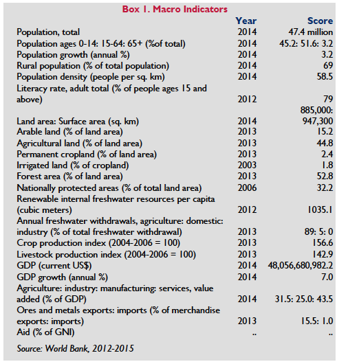
Forty-four percent of Tanzania’s land is classified as agricultural and agriculture accounts for 24 percent of the GDP, 30 percent of total exports and 65 percent of raw materials for Tanzanian industries. Fifty-two percent of Tanzania’s total land area is classified as forest and it is one of the twelve mega-diverse countries of the world, endowed with natural ecosystems that contain a wealth of biodiversity. These resources are threatened by climate change, which has both impacted, and is impacted by, existing land use in Tanzania.
Approximately 90 percent of Tanzania’s poor people live in rural areas. At the same time by 2030, it is estimated that more than 25 million Tanzanians will be living in urban areas. The demand for urban land is significantly exceeding the formal supply—and the gap is widening. Expanding demand is resulting in escalating land prices, urban informality, and proliferating peri-urban development.
The Land Act of 1999 and the Village Land Act (VLA) of 1999 provide the overarching legal framework for land governance and administration. The two land laws establish three basic categories of land: General, Reserved and Village Land. General land is surveyed land that is usually located in urban and peri-urban centers such as legally designated municipalities. Section 2 of the Land Act defines general land as all public land which is not reserved land or village land and it includes unoccupied or unused village land. Reserved land includes that reserved for forestry, national parks, and areas such as public game parks and game reserves. Other categories of reserved land include land parcels within a natural drainage system from which water basins originate, land reserved for public utilities, land declared by order of the minister to be hazardous and public recreation grounds. The Land Act provides the legal framework for General Land and Reserved Land. Under the Land Act, only the Ministry of Lands, through the Commissioner of Lands, has the authority to issue grants of occupancy.
The Village Land Act provides the legal framework for village land. Under the Village Land Act, land is classified as: Communal land, Occupied land, and Vacant land. Village Land is managed by a Village Council elected by a Village Assembly. A Village Council is the corporate entity of a registered village; the Village Assembly includes all residents of a village aged 18 years and above. The Village Council is accountable to the Village Assembly for land management decisions. The Village Land Act gives village government the responsibility and authority to manage land, including issuing Certificates of Customary Right of Occupancy within their boundaries and establishing and administering local registers of land rights. They must apply local customary law, provided it does not conflict with the prohibition of gender discrimination. Some village land has been demarcated but much still needs to be mapped and registered. While some legal experts in Tanzania have argued that villages can lease their lands directly to investors, this position is not universally accepted and is ambiguous under the VLA.
Tanzania’s land laws contain progressive elements in terms of recognizing customary land rights and granting them equal weight and validity to formally granted land rights. However, land insecurity in rural areas is high among small landholder farmers, pastoralists, and women. In urban areas, land is secured through formal and informal land transactions including land allocation from a municipality in an urban or peri-urban area and land purchase, but it is estimated that nearly 60 percent of urban dwellers live in informal settlements and lack tenure security. In general, women’s rights to land are relatively well supported in Tanzania’s formal legal framework. However, despite helpful laws, women continue to face the threat of losing their land as customary laws and norms favor male inheritance. Widowhood or divorce leads to some women losing their land to other, more powerful family members.
Global interest in investing in Tanzania’s rural and urban land has grown in recent years and hundreds of thousands of hectares of land have been acquired by companies in the biofuel, sugarcane, and forestry sectors. The formal land market is very limited and so while some investors follow formal procedures to obtain land rights others may obtain rights informally (without following the statutory processes for acquiring rights to land). In such cases investors may negotiate with traditional village authorities and local government bodies. Under the 1967 Land Acquisition Law the government may also convert lands held by villages to General Land to make it available to investors. If the investment fails, the land, once transferred to General Land, will not revert to back to Village Land because the customary rights that the communities have in Village Land are formally extinguished by the transfer. This leaves communities at risk.
Tanzania is rich in water, and natural resources. For the past decade, the resurgence in global demand for natural resources, including minerals, has been escalating, largely driven by foreign investors. The search for commercial natural resources is now expanding into more remote, and often extremely fragile, regions. At the same time Tanzania is the only country in the world to allocate more than 25 percent of its total area to national parks and other protected area status. It has 14 National Parks, 17 Game Reserves, 50 Game Controlled Areas, 1 Conservation Area, 2 Marine Parks and 2 Marine Reserves. It includes the second largest protected area in the world, the Selous Game Reserve, which is a World Heritage Site. With so much land protected for conservation purposes, and demands for resource exploitation expanding, the government needs to address how to handle competing demands for land to help mitigate or avoid conflicts over increasingly scarce land.
Land
LAND USE
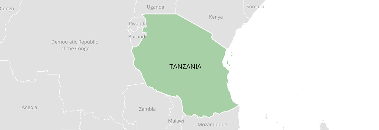
Tanzania has a total land area of 885,800 square kilometers, including 2,643 square kilometers that comprise the Zanzibar archipelago. Tanzania shares borders with Kenya, Uganda, Rwanda, Zambia, Malawi, Mozambique, Burundi and the Democratic Republic of the Congo. The mainland terrain includes highlands in the north and south and a central plateau. The country has large active and extinct volcanoes, including Mount Kilimanjaro and Mount Meru in the north, and a block of ancient rock formations in the east known as the Eastern Arc. Coastal plains run along the 1300-kilometer coastline, and Lake Victoria, Lake Tanganyika and Lake Malawi have a combined 2300 kilometers of shoreline. The Zanzibar archipelago consists of two large islands (Unguja and Pemba) and several smaller islands collectively referred to as Zanzibar.
The mainland, known as Tanganyika, obtained independence from Britain in 1961 and Zanzibar followed in 1963. In 1964, the two regions combined to form the United Republic of Tanzania. Zanzibar has significant representation in the Union Government and is also semiautonomous, with its own president, legislature and bureaucracy and has separate legal frameworks governing land, water and forests (USDOS 2010). Zanzibar has experienced sectarian and political tensions in recent years and the contested 2015 Presidential election, resulting in another re-run election in 2016, has undermined the credibility of electoral processes on the island (Al Jazeera 2015).
Forty-four percent of Tanzania’s land is classified as agricultural, of which 14.3 percent is arable land, 2.3 percent is permanent crops, such as such as coffee, bananas and cassava and 27.1 percent is permanent pasture (World Bank 2014; Central Intelligence Agency, 2016). Agriculture is one of the leading sectors in Tanzania accounting for 24 percent of the GDP, 30 percent of total exports and 65 percent of raw materials for Tanzanian industries. The main food crops are maize, sorghum, millet, rice, wheat, beans, cassava, potatoes, bananas and plantains. Main exported cash crops are coffee, tea, cotton, cashews, raw tobacco, sisal, and spices. It is estimated that only 24 percent of about 44 million hectares of total lands are being utilized. Smallholder farmers primarily hold cultivated lands, with average farm sizes between 0.9 and 3.0 hectares.
After crops, the livestock industry is the second largest contributor to Tanzanian agriculture, representing 5.5 percent of the country’s household income and 30 percent of the Tanzania’s agriculture GDP. As with farming, livestock-raising is primarily undertaken by smallholder farmers (Tanzania Invest 2015). Pastoralists have used the rangelands in what is now Tanzania for hundreds of years, developing a land management system adapted to variable ecological, social and economic conditions. Pastoralists play a dominant role in this sector, contributing greatly to Tanzania’s economy: according to government records, pastoralists and agro-pastoralists rear approximately 98 percent of the country’s some 21 million cattle and 22 million small stock and produce most of the milk and meat consumed nationally. Pastoralists have been, and continue to be, permanently dispossessed of their land holdings, which has reduced the area available to them for livestock production (International Work Group For Indigenous Affairs, 2016b).
Climate change has both impacted, and is impacted by, existing land use in Tanzania. Regarding the former, agriculture is mostly rain fed and thus the success of activities in the sector remains highly sensitive to weather, especially rainfall. Over the last four decades, Tanzania has been hit by a series of severe droughts and flood events as a result of climate change. The consequences of climate change have been a reduction in agricultural production and greater food insecurity (FAO 2014). At the same time, unsustainable land management practices, including continuous cropping (with reductions in fallow and rotations), repetitive tillage and soil nutrient mining, overstocking, overgrazing, frequent rangeland burning, and over-use or clearance of woodlands and forest, are contributing factors in climate change (Gambino and Liwenga 2014).
Fifty-two percent of Tanzania’s total land area is classified as forest. Woodlands occupy about 93 percent of the forested area. The remaining 7 percent is composed of lowland forests, humid montane forest, mangrove forests, and plantations. These resources are currently facing a deforestation rate of 372,000 hectares per year, which results from heavy pressure from agricultural expansion, livestock grazing, wild fires, over-exploitation, and unsustainable utilization of wood resources and other human activities (FAO 2015).
As noted, Tanzania is one of the twelve mega-diverse countries of the world, endowed with natural ecosystems that contain a massive wealth of biodiversity. The country has six out of the 25 world-renowned biodiversity hotspots, hosting more than one-third of the total plant species on the continent and about 20 percent of the large mammal population (GOT 2015a). Tanzania has the second highest proportion of national protected areas, after Zambia. Twenty-eight percent of the country is set aside for national parks, conservation areas, game reserves, and controlled and protected areas (UNEP 2013).
 LAND DISTRIBUTION
As of 2014, Tanzania had a population of nearly 47.4 million people, 69 percent of whom live in rural areas (GOT 2014; World Bank 2015). It is a diverse country, with 120 tribal groups. Approximately 1.3 percent of the population lives in Zanzibar (GOT 2013). Population density varies widely and is highest in the mainland capital Dar es Salaam, followed by Mwanza, Mbeya and Morogoro, the fertile northern and southern highlands, along the shores of Lake Victoria, and in urban and coastal areas. The central region of the country, which has an arid climate and relatively poor soil, is the least populated.
Despite impressive GDP growth over the past decade, Tanzania still remains one of the world’s poorer countries in terms of per capita income. The sustained average annual GDP growth rate of 6 percent, double the average rate of the 1990s, masks disparities across sectors and geographical areas. No region is significantly better off than others and all are very poor by international standards – approximately 90 percent of Tanzania’s poor people live in rural areas. The agricultural sector, composed of a majority of smallholders, has not benefited from the same momentum as other sectors. The incidence of poverty is highest among those rural families who live in arid and semi-arid regions and who depend exclusively on livestock and food crop production (IFAD 2014).
Urbanization is well underway in Tanzania. The largest city, Dar es Salaam, on the country’s eastern coast, has an estimated 2.9 million people. It was the capital until 1996, when the capital was officially moved to the central city of Dodoma (estimated population 1.7 million) (World Bank 2012b). Dar es Salaam remains the commercial center of the country and many government functions continue to be performed there (including land administration). By 2030, it is estimated that more than 25 million Tanzanians will be living in urban areas and the percentage of people living in urban areas is likely to grow from 24 percent in 2005 to 38 percent in 2030 (World Bank 2012a). The urban poverty rate is 15.5 percent (World Bank 2012b)). Recent data suggests that 74 percent of Tanzania’s urban population lives in so-called Low-Income Areas (LIAs) (Komu 2014). Because the urban population is expected to grow at more than twice the rate of the population as a whole, the demand for urban land significantly is exceeding the formal supply—and the gap is widening (Pausche and Bruebach 2012). Urban land pressures have resulted in escalating land prices, urban informality, proliferating peri-urban development, and “land grabbing” (Komu 2014).
Global interest in investing in Tanzania’s rural and urban land has grown in recent years. In response to concerns related to some land transfers the Government of Tanzania in 2013 placed a cap on the amount of land that can be leased by foreign investors. Large-scale land acquisitions for agriculture, biofuels and forestry have encompassed significant amounts of land. For example, the Southern Agricultural Growth Corridor of Tanzania (SAGCOT) is a multi-stakeholder partnership to rapidly develop the region’s agricultural potential. It was initiated at the World Economic Forum (WEF) Africa summit 2010 with the support of founding partners including farmers, agri-business, the Government of Tanzania and companies from across the private sector. The SAGCOT Center supports efforts to meet these objectives, including fostering inclusive, commercially successful agribusinesses that will benefit the region’s small-scale farmers, improve food security, reduce rural poverty and ensure environmental sustainability (SAGCOT 2016). The SAGCOT growth corridor, delineated by “cluster areas,” is being developed to attract and streamline appropriate investment. Cluster areas extend horizontally across the country from the western border to the eastern coast, covering approximately one third of Tanzania’s land mass (Taylor 2015). Hundreds of thousands of hectares of land have been acquired here by companies in the biofuel, sugarcane, and forestry sectors (Ngorisa 2015).
For decades, Tanzania has hosted the largest refugee population in Africa and is considered one of the world’s major refugee-receiving states. According to UNHCR, there are currently 253,190 refugees in the country; Burundian and Congolese refugees comprise the majority. Additionally, the current instability in Burundi has increased the number of individuals seeking refuge in the country (International Refugee Rights Initiative 2015). Many of these camps are located in the northwest regions of the country, including Kigoma, Katavi, and Tabora (UNHCR 2015). Tanzania also hosts a large population of urban refugees. The government estimates the number of refugees in Dar es Salaam alone to be at least 10,000 (Pangilinan 2012).
LEGAL FRAMEWORK
The Constitution of Tanzania (1977, as amended, 1998) provides that every person has the right to own property and the right to have his or her property protected in accordance with the law (GOT Constitution 1977). The 1995 Land Policy reaffirmed that all land in Tanzania is considered public land vested in the President as trustee on behalf of all citizens and established the fundamental principles guiding land rights use and management, which maintained centralized control of land. The Policy recognizes rights based longstanding occupation of land; it encourages productive and sustainable use, notes that women have the same rights to land as men and promotes transparency and citizen participation in decision making related to land.
The Land Policy was followed by the adoption of the Land Act and Village Land Act in 1999, both of which are currently under review for formal amendment (as of 2016). Tanzania’s Land Act classifies land as: (1) Reserved land (2) Village land and (3) General land. Reserved land includes statutorily protected or designated land such as national parks, land for public utilities, wildlife reserves and lands which, if developed, would pose a hazard to the environment (e.g., river banks, mangrove swamps). Village land includes registered village land, land demarcated and agreed to as Village land by relevant Village Councils, and land (other than reserved land) that villages have been occupying and using as village land for 12 or more years (including pastoral uses) under customary law. All other land is classified as General land. General land includes woodlands, rangelands and urban and peri-urban areas that are not reserved for public use. Under the Land Act, general land includes unoccupied or unused village land. General land and Reserved land are governed by the Land Act of 1999, whereas Village land is governed by the Village Land Act of 1999.
The Land Act stipulates that a non-citizen shall not be allocated or granted land unless it is for investment purposes as provided for under the Tanzania Investment Act (GOT 1997). The Tanzania Investment Act does not apply to investments in mining and oil exploration (GOT 1997). Whether or not the corporate body is registered in Tanzania, if the majority shareholders or owners are non-citizens, then it remains a foreign corporation and therefore cannot receive a granted right of occupancy. However, there is a conflict of between the Land Act and Companies Act (GOT 1999a; GOT 2002). The Companies Act provides that any company incorporated under the Companies Act shall have the same power to hold land in Tanzania, which is in direct contradiction to the Land Act. In principle, the Land Act takes legal precedence over the Companies Act (Lui 2014).
Village land is governed by the Village Land Act of 1999. Under this Act, land is classified as: (1) Communal land (e.g., public markets and meeting areas, grazing land, burial grounds); (2) Occupied land, which is usually an individualized holding or grazing land held by a group; and (3) Vacant land, which is available for future use as individualized or communal land (specifically encompassing unoccupied land within the ambit of village land, as opposed to general land). The Act does not recognize grazing land as a separate category, but pastoralists can assert customary rights of occupancy to grazing land (GOT Village Land Act 1999b). Foreigners who wish to occupy and use village land for various purposes can apply to the Village Council for the right to use the land and the Council may grant the non-citizen the right to use and occupy land for a limited period of time and under stipulated conditions.
In Zanzibar, all land was vested in the government in 1965. The Land Tenure Act of 1992 provides that the government can grant rights of occupation, which are perpetual and transferable. The government can cancel the occupation-right if the holder fails to use the land in accordance with good land use principles. The government also retains the right to approve any transfer of land rights under the Land Transfer Act of 1994. Most land-occupancy rights have not been registered and are held and transferred under principles of customary and Islamic law (Mirza and Sulaiman 1998; Jones-Pauly 1998).
Tanzania’s land laws contain progressive elements: they recognize customary land rights and grant them equal weight to formally granted (statutory) land rights (Sec. 18[1] Village Land Act 1999b). The law also devolves decision making at the village level, primarily through the Village Council, an elected body which is required to have 25 percent women members. However, critics of the laws, including Issa Shivji, chair of the Land Commission, contend that the laws actually make large-scale land takings and acquisition easier: for example, government authorities have centralized some elements of land administration, management and allocation in the executive branch of the government (Salcedo-La Viña 2015).
TENURE TYPES
Although a majority of land in Tanzania is held under customary tenure arrangements, all land in Tanzania is considered public land, which the President holds as trustee for the people. The Land Act places ultimate land ownership— “radical title”—in the president as a trustee for all Tanzanians, making land tenure a matter of usufruct rights as defined by various leaseholds. The government retains rights of occupancy, the imposition of development conditions, land rent, and control of all aspects of land use and ownership. Only the Ministry of Lands, through the Commissioner of Lands, has the authority to issue grants of occupancy. It also restricts non-nationals from acquiring land, except acquisitions connected to investments that have approval from the Tanzania Investment Corporation under the Tanzania Investment Act of 1997 (GOT 1999a; World Resources Institute and Landesa 2010).
The Village Land Act recognizes the rights of villages to land held collectively by village residents under customary law. Village land can include communal land and land that has been individualized. Villages have rights to the land that their residents have traditionally used and that are considered within the ambit of village land under customary principles, including grazing land, fallow land and unoccupied land. Villages can demarcate their land, register their rights and obtain a Certificate of Village Land (CVL) (GOT Village Land Act 1999b; World Bank 2010) by working with the appropriate District Land Office. The village government has the responsibility and authority to manage land, including (in conjunction with the appropriate District Land Office) issuing Certificates of Customary Right of Occupancy within the village boundaries, and establishing and administering local registers of village land rights. They must apply local customary law, provided it does not conflict with the prohibition on gender discrimination (GOT Village Land Act 1999b).
The process of issuing Certificates of Village Land to registered villages has been slow. However, as of 2014, and with help from World Bank funding approximately 10,000 CVLs had been issued (World Resources Institute and Landesa 2010; Bruce 2014).
Customary Right of Occupancy. Villagers have a customary right of occupancy for village land that they hold under customary law or have received as an allocation from the Village Council. A CCRO issued by the Village Council to individual villagers affirms customary occupation and use of land by owners, once signed by the Village Chairperson, the Village Executive Officer and the owner, it must be signed and registered by the District Land Officer for final distribution to villagers. Customary rights of occupancy can be held individually or jointly, are perpetual and heritable, and may be transferred within the village or to outsiders with permission of the village council. Village land allocations can include rights to grazing land, which are generally shared. The Village Council may charge annual rent for village land (GOT Village Land Act 1999b).
Granted Right of Occupancy. Granted rights of occupancy are available for General and Reserved land, subject to any statutory restrictions and the terms of the grant. Granted Rights of Occupancy are obtained through the Commissioner on Lands, who is appointed by the President. Grants are available for periods up to 99 years and can be made in periodic grants of fixed terms. Granted land must be surveyed and registered under the Land Registration Ordinance and is subject to annual rent. Squatters and others without granted rights may have customary rights to occupy general land, which may be formalized with a residential license or remain informal and insecure (GOT Land Act 1999a).
Leasehold. Leaseholds are derivative rights granted by holders of granted or customary rights of occupancy. Holders of registered granted rights of occupancy may lease that right of occupancy, or part of it, to any person for a definite or indefinite period, provided that the maximum term must be at least ten days less than the term of the granted right of occupancy. Long-term leases shall be in writing and registered. Short-term leases are defined as leases for one year or less; they may be written or oral and need not be registered. Holders of customary rights of occupancy may lease and rent their land, subject to any restrictions imposed by the Village Council (GOT Land Act 1999a). Foreigners may lease land through long term leases or joint ventures. Using a long lease, a foreign investor will enter into a lease with local land owners for the most part of the term of right of occupancy of that land, save for few days less that term of occupancy. It is worth noting that granted rights of occupancy have a term of up to 99 years with an option of renewal. Under a joint venture arrangement, a foreign company may own up to 49 percent of an entity (a Tanzanian entity must own at least 51 percent of the entity) in which case the joint venture will be allowed to enjoy use of land as a Tanzanian company.
Residential license. A residential license is a derivative right granted by the state (or its agent) on General or Reserved land. Residential licenses may be granted for urban and peri-urban non-hazardous land, including land reserved for public utilities and for development. Residents of urban and peri-urban areas who have occupied their land for at least three years at the time the Land Act was enacted had the right to receive a residential license from the relevant municipality, provided they applied within six years of the enactment of the Land Act (i.e., by 2005) (GOT Land Act 1999a).
In Zanzibar all land is public and vested in the Government. Clove and coconut farms were nationalized and the land apportioned in the Three Acre Plots (TAP) and distributed to peasants, with a caveat that they could not transfer ownership or inheritance rights. Most rural land is either under individual or state ownership. Some of the TAPs have been sold as granted parcels, changed into residential/ commercial lands, been subdivided, or been inherited contrary to provisions of the decree. Based on various sources (e.g. agricultural census data and numbers from the TAP program, less than 10 percent of these parcels were formally (digitally) registered (Bjørn and Sæbø 2015; Lugoe 2012).
Despite laws that prohibit foreigners from owning land, non-residents can obtain land tenure rights of use and occupancy through derivative rights, lease, joint venture, and use rights granted by Village Councils. Derivative rights may be granted to investors wishing to have rights to occupy and use land by the Tanzania Investment Centre (TIC) for a specified amount of time, which cannot exceed 99 years. The TIC grants the investor the derivative right to use and occupy the land, that is classified as General Land. If the investor fails to implement the investment as applied to the TIC, the TIC may re-acquire the land from the investor and the investor will be entitled to be paid compensation for any development made on the land. Foreigners can also enter in lease agreements with Tanzanian citizens who have been granted right of occupancy, provided that the maximum term for which any lease may be executed is less than ten days of the period for which the right of occupancy has been granted. Joint venture agreements between foreign and incorporated companies in which citizen(s) are major shareholders are able to acquire granted right of occupancy, which enables them to use the acquired land for the purposes of the company business. Finally, non-citizens can be granted use rights by Village Councils for a limited period of time under stipulated conditions as indicated by the Village Council and the Village Land Act (Liu 2014; GOT Village Land Act 1999b: GOT Land Act 1999a).
SECURING LAND RIGHTS
Smallholders and Rural Residents
Village Land constitutes nearly 70 percent of all lands in Tanzania and is defined as a) land either originally described as the village area or so demarcated since then; b) land of a given village according to agreement between that village and its neighbors; and c) any land which villagers have been using or occupying for the past 12 years. Village Land at the village level is formally registered by obtaining a Certificate of Village Land, although the Village Land Act provides that villages without this certificate possess customary rights over land, which falls within the definition of Village Land. Once a village has a CVL then villagers can apply for Certificates of Customary Right of Occupancy.
For those living on Village Land, the most common means of obtaining access to land is through inheritance, gifts, borrowing from family members, and land allocations, including leases from village councils. Where land is abundant, an occupier can take possession by clearing and cultivating the land. The most important procedure for enhancing rural land rights is by obtaining a Certificate of Customary Right of Occupancy (CCRO). There are five steps for a villager or non-villager to obtain a CCRO; these are: 1) the landowner submits an application for a certificate to the Village Council, which may be accompanied by information about parcel boundaries; 2) The Village Council reviews the application (if any disputes over land exist the Village Land Adjudication Committee may need to review and, if possible, resolve these); 3) the Village Council issues a letter of offer which stipulates fees, development conditions, yearly rent and other conditions; 4) the landowner submits a written agreement to these conditions on a prescribed form; and 5) the Village Council issues a certificate of “Customary Right of Occupancy.” (GOT Village Land Act 1999b: Mugabe 2013; World Resources Institute and Landesa 2010). In addition, the villagers must work with the Village Council and the appropriate District Land Office to have their landholdings surveyed as part of the CCRO process. Tanzania does not currently support systematic land registration; rather registration proceeds on a “spot” adjudication basis. Donors including USAID, through its Mobile Applications to Secure Tenure (MAST) and Land Tenure Assistance (LTA) activities, have sought to support more systematic adjudication efforts.
Land insecurity in rural areas is highest amongst small landholder farmers, pastoralists, and women (Mugabi 2013). Smallholder farmers have been most vulnerable to tenure insecurity due to large-scale land deals and land acquisition. Since 2005 “land grabbing” issues have returned to prominence in Tanzania’s social and political discourse, as global demand to produce biofuels triggered a wave of controversial land acquisitions in the country by foreign companies. The underpinnings of these large-scale land acquisitions are complex and diverse and include: internal politics, corruption, foreign demand, undervaluation of land and other private assets, and land speculation (Anseeuw et al 2012; Cotula et al 2008). The existing legal framework and the limited capacity of the government to register and enforce rights means the tenure security of village landholders is a continuing issue (Sulle and Nelson 2012; Nelson et al 2012).
Because foreigners cannot own village land, for a foreign company to acquire rights to a parcel of land, pre-existing customary rights to that parcel must be extinguished. This is done through the transfer of Village Land to ‘General Land’, for which a derivative right can be issued by the Tanzanian government. The transfer of land from Village to General categories can only be done by Presidential assent, and compensation, paid only once, must legally be agreed to and given prior to the transfer. If the investment fails, the land, once transferred to General Land, will not revert to back to Village Land, because the customary rights that the communities have in Village Land are formally extinguished. As a result, when foreign companies acquire land for investment purposes, local communities permanently lose their land rights. In some cases, this means that local communities bear perhaps underappreciated risks associated with these commercial investments, in that they permanently lose their key livelihood assets of land (Songa 2015; Nelson et al 2012; Curtis 2015).
Pastoralists
Other causes of insecurity include migration of people in search of land for livelihoods and changes in land use that encroach on existing residents. In Tanzania there are approximately 1.5 million pastoralists spread among five pastoral tribes and communities, with the Maasai being the largest and most well-known. Pastoralists face a number of acute challenges including a shortage of land for grazing (Maliasili Initiatives 2012). Livestock owners can obtain land for grazing under customary law, through a recognized right of customary use under the Village Land Act or by a specific land allocation by the Village Council. However, conflicts over land access prevail due to increased population pressures and the diversification of land use patterns in Tanzania (i.e. expansion of settled and ranching farming, national parks, towns and settlements (Sendalo 2009). Further, pastoral organizations point out that pastures that are lawfully granted may be perceived as idle or bare land and identified for investment purposes (IWGIA 2016b). Additionally, a large part of the land areas used for pastures fall under the category General Land, which is under the exclusive control of central government. Finally, women in rural areas, despite an equitable law, face the risk of losing their land, or having a legal claim to land brought against them. The reasons are broad and varied: customary laws favor male inheritance; widowhood or divorce can lead to some women losing their land to other more powerful family members; high demand for land in peri-urban and fertile agricultural areas has resulted in sharp increases in its commercial value and a great incentive to sell (generally men make these decisions); and the generally patrilineal culture of the country has left women with little voice and land insecurity (Dancer 2015).
Urban Issues
In urban areas, land is secured through both formal and informal land transactions including land allocation from a municipality in an urban or peri-urban area, land purchase, and squatting. Formal land titling in cities is difficult for the poor to access due to complicated procedures and costs of application. As a result of sustained informal growth, over 60 percent of the urban population lives in informal settlements, or slums (UN-HABITAT, 2010). As a result of the Tanzanian government’s ambitious attempt to deal with informality, a large-scale effort was launched in 2005 to bring millions of urban residents onto the formal land registry for the first time by issuing land titles known as “residential licenses.” These licenses were sold cheaply, without the costs and delays of cadastral surveying, identified the rightful owner of the land, provided a guarantee against government expropriation for a fixed term (initially five years), and were not transferrable and, therefore, could not be foreclosed upon by banks. While it is believed that participants did enjoy increased tenure security, the short length of the guarantee (and the prohibition on transfer) might explain why the residential license program eventually failed to gain traction, and why the benefits often associated with land formalization do not appear to be fully emerging in this setting (Colin et al 2015).
Women, children, and refugees are among cities’ most tenure insecure residents. Women have particular difficulties securing and retaining urban housing, a problem made more acute by a housing crisis. Laws and practices are discriminatory relating to inheritance, ownership, mortgage, and divorce. Patriarchal attitudes are entrenched, as regards titling, land, and renting or selling to single women. As a result, women spend significantly more time in informal settlements living in poor quality housing. In addition, they experience more acutely the lack of basic services, and are more exposed to gender-based violence and health risks (Hughes, K., & Wickeri, E., 2011). One in four children lives in a city and the vast majority of urban children suffer from social, physical and environmental problems specific to cities, including overcrowded and sub-standard housing in areas exposed to hazards and a lack of safe places to gather and play (UNICEF 2012). The country also hosts a population of refugees who live outside camps as ‘spontaneous,’ ‘self-settled’ or ‘urban’ refugees. Among urban refugees, the government estimates the number in Dar es Salaam alone to be at least 10,000 (USDOS, 2012). These refugees lack legal recognition as refugees by the Tanzanian government and do not have access to humanitarian aid or resettlement assistance and most fear being identified as refugees. Livelihood and coping mechanisms are curtailed by their lack of legal status and inability to obtain formal permission to reside in Dar es Salaam (Panglinian 2012; Asylum Access 2012).
INTRA-HOUSEHOLD RIGHTS TO LAND AND GENDER DIFFERENCES
 In general, women’s rights to land are relatively well-supported in Tanzania’s formal legal framework: The Constitution and formal law provide for equal rights to property and prohibit discrimination on the basis of sex (GOT Constitution 1977). Tanzania’s 1999 Land Act expressly states that women shall have equal rights to obtain and use land, and that customary law cannot be used to discriminate against women. The legal framework for land rights also provides for women’s representation in governing bodies.
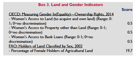
The Village Land Act provides that women must comprise at least 25 percent of the 15-25-member Village Councils. Many of the land-allocation programs have included specific requirements for including widows and women-headed households among the land recipients. Tanzania’s Marriage Act (1971) is also relatively progressive. The Act requires registration of both monogamous and polygamous marriages. Married women are permitted to hold property individually, and polygamous wives have individual rights to hold property. Married couples are presumed to hold land jointly; marital property is co-registered, and spousal consent is required when marital property is transferred or mortgaged (GOT Land Act 1999a; GOT Village Land Act 1999b; Tanzania Law of Marriage Act, 1971). Tanzania has also signed onto a number of international rights conventions that uphold property rights for women and girls including the International Covenant on Civil and Political Rights (ICCPR); the International Covenant on Economic, Social and Cultural Rights (ICESCR); the Convention on the Elimination of All Forms of Discrimination Against Women (CEDAW); the Convention on the Rights of the Child (CRC); and the Protocol to the African Charter on Human and Peoples’ Rights on the Rights of Women in Africa.
Despite these legislative pronouncements, in practice, national and international laws providing for women’s equal property rights are often not followed. For some issues, like inheritance, a body of conflicting and discriminatory law continues to exist. The lack of legal clarity is used to reinforce customary traditions that harm women and patriarchal practices predominate whereby men are de facto heads of households and have greater rights to land than do women (Duncan 2015).
In rural areas in particular, knowledge of the land laws is not widespread, and even where the formal laws are known, customary law and religious practices continue to govern how land is accessed and transferred. Most women access farmland from their natal families. If a woman’s clan follows a patrilineal and patrilocal system, as does the majority of the population, she will move to her husband’s village when she marries and will cultivate his land and the land of his family. A woman’s rights to the land thus depends upon her marriage, and these rights are usually lost if she divorces or becomes widowed. In matrilineal societies (a minority of the population, located primarily in the central and southern regions of the country), assets traditionally passed through the woman’s line, but male family members often controlled the assets, including land. Matrilineal systems that include matrilocal marriage (husband moves to wife’s village) tended to have the most egalitarian distribution of assets, but patrilineal/patrilocal (wife moves to husband’s village) systems have become increasingly favored. For the 35 percent of the country’s women who are Muslim, Shari’a law provides them with one-half the share of men, and a widow with children receives a one-eighth share of her deceased husband’s estate (one-fourth if there are no children) (FAO 2010a; Benschop 2002).
As a result of customary practices, which require women to access land through their fathers, brothers, husbands, or other men who control the land, women are rendered vulnerable. If she loses her connection to this male relative, either through death, divorce or migration, she can lose their land, home and means of supporting themselves and their families. Where women do have access to land, many studies show that women are allocated the smallest and least productive plots (Deere et al 2012; FAO 2011). The country’s proposed new constitution, which provides women with equal rights to own and use land, would override the current customary practices that weaken women’s rights to land (Mushi 2014). However, as of mid-2015, a referendum vote on the new Constitution had been delayed (Reuters 2015).
LAND ADMINISTRATION AND INSTITUTIONS
The President of Tanzania serves as the trustee of all land and is responsible for allocations of General land. The Ministry of Lands and Human Settlement Development (MLHSD) generally executes these responsibilities. The mandate of the Ministry is to facilitate the effective management of land and human settlements development services for the social and economic well-being of the Tanzanian society. The Ministry houses the Departments of Land Administration, Survey and Mapping, Physical Planning, and Housing. It directs the establishment of land policy and planning and is responsible for administering Reserved land and General land, including the allocation of granted occupancy rights and management of the country’s land resources. Core sector units also include Registration of Titles, Property Valuation, and District Land and Housing Tribunal (GOT 2016a). A Commissioner of Lands executes most of the Ministry’s responsibilities (GOT Land Act 1999a and GOT 2016b). The Land Commissioner’s functions include: overseeing implementation of the Land Acts; managing land acquisition, revocation and transfer processes; facilitating land development projects; overseeing administration of General land; and resolving land disputes administratively. There are three sections within the office of the Land Commissioner: Urban Land Administration Section, Rural Land Administration Section, Land Administration Legal Services Division and seven Zonal Land Administration Offices. Each section and Zonal Land Administration Office is led by an Assistant Commissioner (GOT 2016b).
Tanzania’s 30 regions are divided into districts and subdivided into divisions (Tanzania Daily News 2012). Within the Tanzanian context, therefore, decentralization is the transfer of responsibility from the Central to the Local Government. The Decentralization-by-Devolution policy was initiated in 1996 after being endorsed by the government in the Policy Paper on Local Government Reform. The reforms contained in the policy paper clearly laid out policy of devolution of functional responsibilities versus the earlier de facto de-concentrated approach to governance, which had continued to persist despite the reintroduction of elected local governments.
On the mainland, urban authorities consist of city councils, municipal councils and town councils. The rural authorities are the district councils, township councils and village councils. District councils coordinate the activities of the township authorities and village councils, approve village council bylaws and coordinate land use planning district-wide (GOT 2016a). Decentralization within the country in general and within land administration specifically, is now under way in the context of a locally empowered though centrally planned and implemented extension of land registry services, closely tied to the program of systematic adjudication and registration of land rights. During this most recent wave of land reforms Tanzania has been attempting to uphold customary land rights and develop a formalized universal land administration system that encompasses village (customary) lands (Fairley 2012). Administration and management of land is decentralized to the Village level, and is addressed by the Village Land Act, 1999. The Act mandates two local authorities to administer and manage village land: the Village Council and the Village Assembly. The Village Councils have the responsibility for formulating Village Land Use Plans for their areas, managing village forest reserves and collecting revenue including any land rents. Village Councils are elected by the Village Assembly, which includes all adult residents. One-quarter of the council must be female. The urban and district councils are comprised of members elected from each ward (wards are the government unit above villages), plus women appointed by the National Electoral Commission in proportion to the number of elected positions held on the council (not less than one-third).
A village adjudication committee marks land boundaries, sets aside land for rights-of-way and settles boundary disputes between villagers. The power of allocation of village land by the Village Council is, however, subject to the approval of the Village Assembly, which is the supreme authority on all matters of general policy-making in relation to the affairs of the village. It has been observed that de facto allocation of land occurs by Village Councils without approval of the Village Assembly for two main reasons: First the Certificate of Village Land gives power to the Village Council to manage village land. At the same time the legal requirement that they manage land as trustees of the villagers and with the consent of the Village Assembly is unclear to them due to lack of public information and training (Luhulu 2015, Van Gelder 2010).
Although the current land governance structure is designed to foster decentralized land administration, the central government continues to exercise significant authority over land through the Land Commissioner and, to a lesser extent, the District Councils and District Land Offices. (GOT Village Land Act 1999b). (GOT Village Land Act 1999b). For example, there is an unclear division of labor between the Ministry of Lands, Housing and Human Settlements and village land authorities. Resource supports to village authorities to make their land institutions operate as prescribed by law is not sufficient. Finally, although the legal framework requires consultation with the Village Council, but Council approval is typically assumed. In many areas, Village Councils are also constrained in exercising their authority and responsibilities by their lack of knowledge – of the land laws and procedures generally, and obligations regarding women’s land rights in particular (GOT Village Land Act 1999b; Luhulu 2015).
LAND MARKETS AND INVESTMENTS
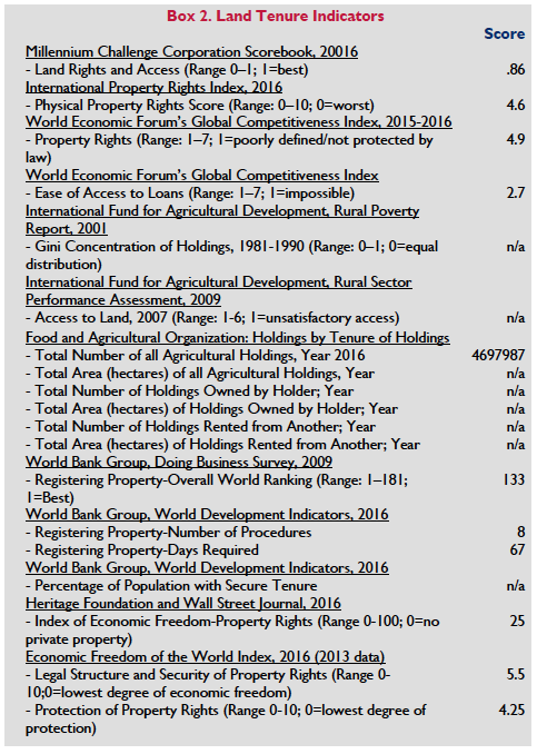
There is a very limited formal land market in Tanzania, and little information is available concerning its operation. Much of this is a reflection of problems associated with land registration. As of 2014 only three percent of the land in Tanzania has been registered and most of what is registered is in urban areas. Only 7.7 percent of villages have developed land use plans. In principle, rights of occupancy can be bought, sold, leased and mortgaged in Tanzania.
Primary constraints to development of the formal land market include: (1) the requirement for pre-sale notification of the Land Commissioner about the intended transaction; (2) the requirement that the Commissioner acknowledge such notification as a condition for registering the transaction; (3) prohibition of sale of land rights held for less than three years; and (4) the ability of the Land Commissioner to void a land transaction anytime within two years of the transaction if the Commissioner has reasonable cause to believe there has been fraud, undue influence or lack of good faith in the transaction (GOT Land Act 1999a; GOT Village Land Act 1999b; Sundet 2005; Kironde 2006). A holder of a customary right of occupancy can sell the right, subject to the approval of (and subject to any restrictions imposed by) the Village Council. Formal law regulates mortgages, and land rights must be registered before they can be mortgaged (Sundet 2005; Kironde 2006; GOT Land [Amendment] Act 2004).
The fundamental constraint to a robust land market is a lack of secure land titles (both statutory and customary) and an abundance of unsurveyed land. For example, data from the Bank of Tanzania suggests that 75 percent of land is not surveyed in Dar es Salaam. The market is also constrained by long, costly, and uncertain land registration processes. Tanzania ranks 123 of 189 economies in terms of ease of registering property on the World Bank’s 2015 Doing Business Report. It takes eight procedures and 67 days to register a property, at a cost of 4.5 percent of the property value, almost three times longer than the time it takes in Organization for Economic Cooperation and Development (OECD) countries, but comparable in terms of cost. (World Bank 2015b; Centre for Affordable Housing Finance Africa 2015). However, efforts to improve land registration processes such as utilizing the Fit For Purpose Framework( FFP) a concept that encompasses a dynamic interaction of the spatial, legal, and institutional frameworks has enabled Tanzania to implement new and participatory approaches for capturing land rights information, as well as a lower cost methodology for quickly building a reliable database of land rights as an alternative to more traditional, and more costly, land administration interventions (USAID 2014).
A land market does exist for non–residents, through lease, and for domestic investors. However, Section 4 of the Village Land Act, confers to the President the right to transfer Village land to General or Reserved land for purposes of “investments of national interest.” This provision is viewed as essentially compulsory acquisition with some decision-making yielded to the village community. Further, Village lands not under cultivation or permanent settlement, or set aside for grazing, commonage, or for future use or population expansion may be easily by interpreted by government authorities as “unoccupied” or “unused” and made available to investors. The Land Act’s does not explain what the terms “unoccupied” or “unused” mean, and the phrase does not appear in the definition within the law. The result is a legal loophole that makes village land susceptible to allocation to outsiders (Makwarimba and Ngowi 2012).
The Tanzania Land Bank Scheme was created under the Investment Act; it identifies land as suitable for investment and the Tanzania Investment Centre acts as the broker for investors. The Land Bank was considered generally unsuccessful because the parcels it holds are too few, too small, and too scattered to be of much interest (Makwarimba and Ngowi 2012).
As a result of these issues, most land transactions, both urban and rural, occur on the informal market, and these tend to be leases. In rural areas, land sales were historically conducted between members of families or clans; landholders tended not to sell rights to buyers from outside the village. Since the end of the villagization project, and in keeping with the growing commoditization of land, the informal market has expanded; there is increasing demand for land in productive areas and areas with high potential for commercial development. In some cases, investors and land speculators follow formal procedures to obtain land rights, but in many cases buyers proceed informally, negotiating with traditional village authorities and government bodies, with the transaction evidenced by an informal deed signed by representatives of the official or traditional village authorities (Centre for Affordable Housing Finance Africa 2015).
COMPULSORY ACQUISITION OF PRIVATE PROPERTY RIGHTS BY GOVERNMENT
The Constitution allows for the State to compulsorily acquire property for a list of broadly defined public purposes, including “enabling any other thing to be done which promotes, or preserves the national interest in general” (GOT 1977). The Land Act (1999), the Land Acquisition Act (1967) and the Urban Planning Act (2007) give the President overwhelming powers to acquire land needed for public use or interest. Compulsory acquisition laws stipulate that persons whose land is expropriated for public interest have to be fairly and promptly compensated. The compensation payable to dispossessed persons is based on the market value of the property or land. The spirit of the compensation is to ensure that affected households neither lose nor gain as a result of their land or property being appropriated for public interests (GOT Land Act 1999a; the Land Acquisition Act 1967; Urban Planning Act 2007; Kombe 2010). Compulsory acquisition was used during the process of moving the capital of the country from Dar es Salaam to Dodoma.
The Land Acquisition Act of 1967 and the Land Act of 1999 govern compulsory acquisition. Both include “development of agricultural land” as a valid public purpose for the State to acquire land compulsorily, leaving the door open for wide application of the state’s acquisition authority in the face of increased commercial interest in land investment in Tanzania. The 1970–1977 villagization program was based on the President of Tanzania’s authority to acquire and reallocate land. Hundreds of thousands of Tanzanians were resettled in the 1970s to implement a public policy of communal production and shared labor. The 1977 Constitution of Tanzania (as amended in 1998) provides some protection against the introduction of similar programs, mandating that no one can be deprived of property for purposes of nationalization or other purposes except in accordance with law and upon the government’s payment of fair and adequate compensation. However, the Constitution, the 1967 Land Acquisition Act, and land laws of 1999 do permit the President to acquire General, Village or Reserved land for public purposes. As noted, public purpose is defined broadly and includes public works, commercial development, environmental protection and resource exploitation (GOT Constitution 1977; GOT Land Acquisition Act 1967; GOT Village Land Act 1999b; GOT Land Act 1999a).
The laws governing land acquisitions state that the government must give landholders at least six weeks’ notice of the acquisition, but provide that the President has the discretion to shorten this notice period. The government must promptly pay landholders fair compensation, including annual interest of 6 percent for any delay in payment. The Land Act identifies seven factors to be considered in determining fair compensation: (1) the market value of the property; (2) disturbance allowance; (3) transport allowance; (4) loss of profits or accommodation; (5) cost of acquiring the subject land; and (7) any other cost loss or capital expenditure incurred in the development of the subject land. The government can offer landholders alternate land in lieu of or in addition to monetary compensation (GOT Village Land Act 1999b; GOT Land Act 1999a).
In practice, land expropriation is often not conducted in accordance with legal requirements. In some cases, the government converts Village land to General land to make it available to investors without paying villagers adequate compensation and without requiring or encouraging joint ventures or other local community participation in land development and enterprises. In addition to failing to compensate cultivators for the value of annual harvests lost, government compensation may fail to compensate other users of land, such as pastoralists and users of forest resources. Pastoralists in particular have lost land to tourism development, national park expansion, and infrastructure development. In some cases, investors have circumvented the requirement for government land expropriation and dealt directly with villages. Village Councils may be incentivized to negotiate directly with investors rather than wait for government intervention because the councils have an opportunity to set annual rent and request premium payments from the investors (World Bank 2010; Kironde 2009; Pallotti 2008; Hakiardhi 2009).
Compulsory acquisition practices also impact cities, especially the urban poor. In recent years, the urban landscape has been transformed in Tanzania. Despite the fairly small proportion of the population that lives in cities, the proliferation of informal land markets, land grabbing, speculation and expropriation. As a result, land values and speculation have been increasing persistently without providing an alternative resettlement area or paying fair compensation. The livelihoods of many households are more precarious. For example, urban farming, which promotes food security for residents, is threatened, and land-related conflicts have intensified especially in the peri-urban areas (Kombe 2010).
In both rural and urban settings, the Land Acquisition Act does not provide any specific protection for women or spouses. Women have been disproportionately affected by acquisitions in terms of land based, livelihoods, ability to feed their families, loss of water rights and general disempowerment. Widowed and single women have been even more impacted, as relocation has proven extremely difficult for them (Matupo 2015).
LAND DISPUTES AND CONFLICTS
Persistent and escalating land disputes and conflicts are a feature of both rural and urban areas. In rural areas, conflicts are tied to increasing population pressure and the diversification of rural land use patterns (i.e. expansion of settled and ranching farming, national parks, towns and settlements); competition for natural resources such as land, water and minerals; conflicts over land uses, such as grazing versus cultivation; demarcation of village boundaries and allocation of common resources; promotion of commercial development; and adoption of land use plans that deny local communities access to land and natural resources needed for livelihoods (Kombe 2010; Chachage 2010). In some cases, disputes have become violent. For example, since 2015 violence in the Morogoro region between Masaai and Datoga citizens has resulted in burned villages, assaults, confiscations of livestock and property, and deaths. Though characterized as “ethnic conflict,” observers have stated that the conflict is the result of a series of attempted land grabs, where people have used their political influence to access the wetlands in Mabwegere and Kambala Villages. It is reported that the violence against the Maasai is well organized and financed by politicians, public servants and other well-connected people with economic interests in the land currently belonging to the Maasai community (IWGIA 2015).
In rural areas both formal and informal tribunals have jurisdiction to hear land disputes under Tanzania’s formal law. The Courts (Land Disputes Settlements) Act of 2002, the Land Act and the Village Land Act recognize the jurisdiction of informal elders’ councils, village councils and ward-level tribunals. Village Councils can establish a land adjudication committee, with members elected by the Village Assembly. The primary mode of dispute resolution in these forums is negotiation and conciliation. Forums provide a mechanism for local level dispute resolution. If disputes cannot be solved with Land Adjudication Committees, then cases may be taken to ward-level tribunals and/or to courts. Local forums may, however, reinforce existing hierarchies, and women and socially marginalized people may obtain less equitable results than if they had brought their claims in other tribunals. Nonetheless, many people prefer the rapid and socially legitimate results that can be achieved using local relationships and institutions (Odhiambo 2006; Odgaard 2006).
In urban and peri-urban areas land tensions are rooted in land scarcity, which refers to the unavailability of planned, surveyed and serviced land parcels and has been manifest in government authorities struggles to provide formal land plots in numbers near the level of demand over the last 25 years. As a result, most of the country’s spatial expansion has been in informal and unplanned settlements. For example, only a small share of Dar es Salaam’s expansion has been done through the channel of formal land administration that follow statutory procedures for planning, transacting land and development. Consequently, settlements have sprung up as slums, sprawling, unplanned, poorly serviced and hurriedly constructed (Magembe-Mushi and Lashala 2015; Locke and Henley 2016). Its residents possess only marginal security of tenure for the majority of properties in slums since they were built on land that was neither acquired nor properly granted by urban authorities. Urban land conflicts include landlord and tenant contract conflicts, boundary conflicts, easements and double allocations, and trespassing. In cases where residents, both formal and informal are removed for urban planning schemes, such as housing, infrastructure or roads conflicts emerge for the following reasons: delayed and/or unfair compensation, poor communication and non-involvement of landowners, and unresponsive land administration and governance. (Kombe and Kreibich, 2006; Sackey 2010; Locke and Henley 2016).
There are a number of options of justice systems available for land dispute resolution in more urban areas. Formal justice systems specifically established by the Land Disputes Court Act, 2002 to determine land disputes are ward tribunals and District Land and Housing Tribunal. The High Court (Land Division) and Court of Appeal of Tanzania are also higher courts that deal with land dispute of national interest and appeals from all the District Land Tribunals. Other systems such as the NGOs, university-based law clinics, the National Land Committee play active roles in one way or the other in the resolution of land conflicts. Though their decisions are not binding, they play a crucial role in the resolution of land conflicts (Sackey 2010)
Observers have noted that while conflicts in Tanzania, both rural and urban, are often expressed as a function of demographic and environmental pressures, ethnic conflicts, and conflicting land use, the root causes of rural land disputes and conflicts include policy deficiencies and contradictions, insecurity of land tenure, inadequacy of capacity of the local institutions, corrupt practices, inadequate capacity and resources in village land use planning, and ineffective approaches used to resolve the conflicts (Mwamfupe 2015).
KEY LAND ISSUES AND GOVERNMENT INTERVENTIONS
The government’s National Strategy for Growth and Reduction of Poverty 2011/12–2015/16 (Mkakati Wa Kukuza Uchumi na Kupunguza Umaskini Tanzania II, or Mkukuta II) is the country’s organizing framework for the development of government programs. The strategy identifies urban growth and agriculture as priority areas for interventions. The strategy includes plans to support the managed growth of urban settlements with: (1) development of settlement plans, land surveys and gender‐balanced issuance of land titles; (2) establishment of land reserves in peri‐urban areas; (3) regularization of unplanned settlements; (4) capacity-building for local leaders, including education and awareness-building on land rights, obligations and women’s rights. In the agricultural sector, Mkukuta II recognizes challenges posed by inadequate technical support for small farmers, lack of irrigation and other rural infrastructure, environmental degradation and lack of financing for investment. Planned interventions include: (1) improving and expanding irrigation infrastructure and developing rainwater-harvesting infrastructure; (2) developing contract-based grower and producer relationships; and (3) supporting access to and expansion of land for agriculture and livestock-development in a manner that balances the demands for large- and small-scale farmers (GOT 2010).
The Government’s Long-Term Perspective Plan (LTPP) and Tanzania Development Vision 2025 are important developments, both aimed at transforming the country into a Middle Income Country by 2025 through a gradual industrialization of the agriculture-based economy using the country’s significant natural resources, in particular recently discovered natural gas, as well as leveraging the country’s strategic location in relation to regional and global value chains (Kibugi et al 2015; UNDP 2016). Kilimo Kwanza, launched in 2009 and concluding in 2016, is a central pillar in achieving the country’s vision 2025. Kilimo Kwanza (Agriculture First) is a national resolve to accelerate agricultural transformation in line with other strategic frameworks including Agricultural Sector Development Strategy (ASDS), Agricultural Sector Development Programme (ASDP), Comprehensive African Agriculture (CAADP)-TAFSIP, SAGCOT that place emphasis on agriculture transformation from subsistence to commercial. In terms of the land sector Kilimo Kwanza seeks to “facilitate access to land for agriculture, enhance security of tenure, promote the harmonious and judicious exploitation of the land resource and create an enabling environment for using land to access credit.” (GOT 2011a: GOT 2011b; GOT 2009).
On June 15, 2013, at the G8 Summit in the United Kingdom, the Government of Tanzania (GOT) and the G8 countries announced the Tanzania-G8 Land Transparency Partnership (TLTP). The partnership aims to support a more transparent, efficient and better-resourced land sector to ensure that current and future demand for land leads to beneficial and equitable outcomes for rural populations, and that Tanzania continues to attract and support high quality investment. DFID (with the support of SIDA and DANIDA) has been working with the GOT to develop a program known as the Land Tenure Support Program (LTSP) to begin implementing the partnership (see below). The initial three-year program aims to address weaknesses in the land administration system that constrain efficient delivery of land services and good governance, targeting processes of how land certificates are issued to rural and urban citizens, and how land is leased to investors. The LTSP seeks to enable the Government of Tanzania to make information on land records and processes of land allocation publicly available and clarify and address current constraints to protecting landholders. A component of the program is to introduce a multi-stakeholder group to raise the role of civil society oversight of government services and actions in the land sector. Ultimately, it aims to establish a road map for long-term support to the land sector that will contribute to sustained implementation of the government of Tanzania’s revised Strategy and Policy for Implementing Land Legislation (SPILL) These measures are also expected to strengthen security of tenure, contributing to growth in agricultural production and more and better-planned investment in urban infrastructure, including housing (Locke et al 2013; Mcilone 2016). The program was launched on February 28, 2016.
DONOR INTERVENTIONS
In 2015 and 2016, USAID piloted a project to crowd-source land rights information at the village level in Tanzania using mobile technology. The Mobile Application to Secure Tenure (MAST) project (formerly the Mobile Technology Pilot) supports identified needs of the Government of Tanzania to improve land governance and lower the cost of land certification programs. The pilot tested a new, participatory approach for capturing land rights information, as well as a lower cost methodology for quickly building a reliable database of land rights claims. The MAST technology tool may be helpful to the Government of Tanzania as an alternative to more traditional, and costlier land administration interventions. The pilot approach combined relatively inexpensive and readily available mobile technologies (e.g., GPS/GNSS-enabled smart phones and tablets) with broadly participatory crowd-sourced data collection methods in rural and underserved settings. (USAID 2014). USAID is currently scaling up MAST through its Feed the Future Tanzania Land Tenure Assistance activity (LTA). The objectives of the four year (2015-2019) activity include are to reduce land tenure-related risks and lay the groundwork for sustainable agricultural investment for both smallholder and commercial investors throughout the Southern Agricultural Growth Corridor of Tanzania (SAGCOT). The project: a) assists villages and district administrations in completing the land-use planning process and delivering Certificates of Customary Rights of Occupancy (CCROs) in selected villages within two districts (Iringa and Mbeya); b) builds the capacity of village land governance institutions (Iringa/Mbeya); and. c) builds capacity to use the MAST technology application throughout SAGCOT and nationally.
The World Bank is providing funding for Private Sector Competitiveness Project (PSCP), approved in 2013, aims to focus on land administration reform and improved access to financial services, to spur economic growth and improve shared prosperity. The PSCP supports activities designed to improve land registration, land use planning and regularization of tenure rights. The project originally began piloted a faster land demarcation and registration approach to replace the traditional high cost registration on demand, (which is about 10 times more expensive). Today’s project will help to further advance land administration reform, complete business registration reform, and help implement the Government’s recently announced initiative to speed up delivery of priority programs such as agriculture, education, energy, transport and water (World Bank 2013).
Finland’s Sustainable Management of Land and Environment Programme 2010-2015 (SMOLE II), has implemented in collaboration with the Ministry of Agriculture and Environment and the Ministry of Water, Land, Energy and Construction, seeks to promote sustainable management of natural resources and environmental protection and to address climate change vulnerability in Zanzibar’s main island (Unguja) and in Pemba. The project has supported land use planning, improving people’s rights to land and housing, and establishing a modern land information system that includes land registration. Several national policies and plans have been reviewed and updated, including national and district land use plans and land use, forest and environmental policies. Community forest management sites have been selected and in the main island of Zanzibar, Unguja, draft agreements have been submitted for legal review. Various natural resource management pilots have also been completed, including the rehabilitation of stone mining sites. Various databases and a land registration system have been developed, which are now in open-access Zanzibar Land Information system ZALIS (Embassy of Finland 2015).
In 2016 DFID, DANIDA AND SIDA co-funded, and launched the Land Tenure Support Programme, which will support the Government of Tanzania, through the Ministry of Land Housing and Human Settlements Development (MLHHSD), to make information on land records and processes of land allocation publicly available, and clarify and address current constraints to protecting legitimate land claims. Ultimately, these measures are expected to strengthen security of tenure, contributing to growth in agricultural production and more and better-planned investment in urban infrastructure, including housing Irish Aid has been working with Tanzania since 1975 with a mission to support smallholder farmers and pastoralists to increase farm productivity and improve the farming business environment. Irish Aid’s approach is to work closely with agriculture sector ministries and by supporting research and planning processes at the national level. Programs aim to increase farmers’ income through livelihoods program and assistance to farmer networks. Recent initiatives including pastoralist civic society organizations, to better organize themselves to be heard at a national level, particularly on matters that concern them such as land rights, good market regulatory framework and policies, and access to services. The 2015 “Pastoralist Programme”, funded by Irish Aid and implemented by Care International and the Tanzania Natural Resource Forum (TNRF), provides capacity building and funding for community-based organizations (CBOs) on securing resource access through improved local land management, gender rights and climate change awareness training. It also supports civil society organizations to advocate for “pro-pastoralist” policy at the level of national government (Irish Aid 2015).
Freshwater (Lakes, Rivers, Groundwater)
RESOURCE QUANTITY, QUALITY, USE AND DISTRIBUTION
Tanzania has substantial freshwater resources, including three large lakes that it shares with other countries and that account for about 6 percent of total surface area of the country. Tanzania has eight river basins. The country borders the three largest freshwater lakes in Africa – Tanganyika, Victoria and Nyasa – which represent a huge natural storage capacity for Tanzania, holding almost 400 times the mean annual runoff from all of its rivers. About half of the country’s surface runoff comes from rivers flowing into the Indian Ocean (including the Pangani, Rufiji, Wami, Ruvu and Ruaha rivers); part of the rest drains into the lakes Victoria (Meri, Maru and Kagera rivers), Tanganyika (Malagarasi), Rukwa, Bubu, Eyasi and Manyara as well as the Lake Nyasa/Zambezi river system (Songwe and Ruhuhu rivers).
Lake Victoria in the northwest (shared with Uganda and Kenya) has a surface area of about 69,000 square kilometers and is the second-largest freshwater lake in the world (after Lake Superior in the U.S./Canada). Tanzania has a 51 percent share of the lake. Tanzania also has a 41 percent share of Lake Tanganyika on its western border (shared with Burundi, the Democratic Republic of Congo and Zambia), and an 18 percent share of Lake Nyasa (also known as Lake Malawi) in the southwest (shared with Malawi and Mozambique). The country’s largest rivers are the Rufiji, the Great Ruaha, the Igombe and the Ruvuma. Tanzania has nine drainage basins, including the Lake Victoria basin, which is part of the Nile River basin (GOT 2012).
Tanzania’s annual renewable water resource is 89 km3 and the annual average of available water per capita was 2,000 km3 in 2012 compared to 2,700km 3 in 2001. This amount is projected to lessen by 30 percent, to1400 cubic meters per capita in 2025 as a result of diminishing water resources and increasing population. Between 2006 and 2014 many areas of the country continued to receive average rainfall in general. However, the country is challenged by a high degree of water resource variability, both spatially and temporally. National mean annual rainfall is 1,071 mm, but the Lake Tanganyika basin and the southern highlands can receive up to 3,000 mm annually while about half the country receives less than 762 mm annually. Temporally, the northern parts of Tanzania experience a bimodal rainfall pattern (long rains from March to May and short rains from October to December).
On the mainland, current coverage estimates from the Ministry of Water and Irrigation (MoWI) are 58.7 percent in rural areas, 53 percent in small towns, and 84 percent in urban areas and 68 percent Dar es Salaam. In rural areas as many as 46 percent of water points not functional. In urban areas access to piped water in urban areas has declined even more rapidly, going from 79 percent in 2000 to only 62 percent in 2007. The capital city, Dar es Salaam, experienced the largest drop: access to piped water declined from 93 percent in 1991 to 58 percent in 2007. Rapid urbanization is one of main causes of these declines (African Ministries Council on Water 2011; Noel 2013). According to the government, 76 percent of Zanzibar islanders, the vast majority of whom live in rural areas, have access to safe water. However, residents face the constant threat of impurities and breakdowns. Supplies by water trucks are more reliable but can only be afforded by those with stable incomes. The rural population has to frequently access drinking water from precarious sources, such as contaminated boreholes or rivers. In addition, rising sea levels have resulted in seawater mixing with fresh water supplies and contaminating the wells. Zanzibar does not have rivers and the main source of water is groundwater, which depends on the currently erratic rainfall (GIZ 2016; Kabendera 2013; African Development Bank 2015).
Although it has institutions, policies, and regulations in place to promote proper water management Tanzania has experienced widespread shortages in its surface and groundwater in many areas. The water shortages result from a number of factors including reduced and delayed rains, water scarcity in certain regions and river basins, increasing multi-sectoral demands, degradation of water catchments due to pollution, poor land use practices, and encroachment of land for agriculture, urbanization and industrial development. In terms of water resource management, incomplete decentralized management and adoption of appropriate technologies; emphasis on water supply than water resources management; insufficient water governance at all levels, incomplete inadequate hydrological data and information; and inadequate water storage infrastructure are impeding the country’s ability to sustainably provide access to clean and safe water. Climate change further stresses the nation’s water resources (GOT 2014; Noel 2013: GOT 2012).
LEGAL FRAMEWORK
The framework for water sector policy in Tanzania stems from Vision 2025 and the National Strategy for Growth and Reduction of Poverty (NSGRP/MKUKUTA). These existing policy and strategy documents contain operational targets to be achieved in terms of level and timescale for improving water resources management, and water supply, sewerage and sanitation. Consideration of these targets was one of the starting points for developing the National Water Policy and National Water Sector Development Strategy (GOT 2008).
In 2002, the government issued the National Water Policy, which was designed to address: the competing demands on the country’s water resources; scarcity of water in some regions of the country; degradation of water sources; inadequate access to safe drinking water; and fragmented planning. The National Water Policy is based on principles of: (1) equal and fair access to and allocation of water resources; (2) effective and efficient water-resources utilization; (3) better management of water quality and conservation; (4) better management and conservation of ecosystems and wetlands; (5) financial sustainability and autonomy of Basin Water Boards; and (6) promotion of regional and international cooperation in the planning, management and utilization of water. The policy supports decentralized water-management and revision of the existing perpetual water-right system to a system allocating water rights for a specific duration (GOT 2002b).
The 2006 National Water Sector Development Strategy (passed in 2008), designed to implement the 2002 National Water Policy, recognizes the importance of universal access to improved water supply and sanitation and the need to develop institutions and methods capable of rapidly expanding services across the country. It focuses on water-resources management, institutional development and capacity-building, development of district water supply and sanitation plans, execution of business plans for utilities operating in regional and district capitals and plans for water delivery and management in small towns (GOT 2008).
The 2009 Water Resources Management Act (Water Resources Act) implements the 2002 Water Policy and 2006 Water Sector Development Strategy. The Act creates the institutional and legal framework for the sustainable management of the country’s water resources. The Act regulates the management, use and protection of the country’s water resources for the benefit of the population, to meet basic human needs and promote equitable access, and to support the sustainable efficient use of water resources. The Act sets out the ownership and use structure for water resources and the governance structure, which includes National Water Boards, Basin Water Boards, Catchment and Sub-Catchment Water Committees and Water User Associations (GOT Water Resources Act 2009a).
A companion law, the 2009 Water Supply and Sanitation Act, focuses on the supply of drinking water and sanitation services. The Act provides for the transparent regulation of water supply and sanitation services and the creation of authorities to manage water supply and sanitation sustainably. The Act restructures the water supply sector around decentralized and devolved authorities, which are designed to be commercial entities, and outlines the responsibilities of government authorities involved in the water sector. The Act provides for the creation of Community Owned Water Supply Organizations (COWSOs) to manage potable water resources at the local level. The law gives COWSOs ownership of water points and infrastructure, empowers COWSOs to grant and deny access to water in accordance with established conditions, and grants COWSOs the right to levy fees for water services (GOT Water Supply Act 2009b).
The 2002 Water Policy and 2009 Water Resources Act and Water Supply and Sanitation Act reflect the country’s effort to devolve authority for the management of natural resources to the local level and establish sustainable systems for natural resource management. This legal framework emphasizes shifts planning and management of water resources closer to beneficiaries, encourages multi-objective planning and private-sector participation, and promotes economic sustainability (GOT Water Supply Act 2009b).
Zanzibar enacted a new water law in 2006 (Water Act No. 4 of 2006) to control water-use on the island and prevent water pollution. The law declares all water resources to be the property of the government and imposes a fee for the use of all water other than rainwater and seawater. Zanzibar’s 2007 Strategy for Growth and Poverty Reduction identifies the water sector as a priority area and provides that the government will implement this legal framework, develop plans to protect water catchments, conduct research on groundwater potential, rehabilitate infrastructure, promote and strengthen public-private partnerships in water development, supply and financing, and promote community-based management of water supply (GOZ 2007).
The Nile Basin Initiative (NBI) is a cooperative framework created in 1999 to govern Nile Basin water resources. All ten riparian states (Tanzania, Kenya, Uganda, DCR, Egypt, Sudan, Burundi, Rwanda, Eritrea and Ethiopia) signed the agreement and committed to developing cooperative-use agreements to achieve sustainable development through the equitable utilization of the common Nile Basin water resources. A feature of the Initiative, though controversial, is a ‘water security’ provision which defines ‘water security’ as “the right of all Nile Basin States to reliable access to and use of the Nile River system for health, agriculture, livelihoods, production, and environment” and provides “that the cooperation management and development of waters of the Nile River System will facilitate achievement of water security and other benefits” (Wouters 2013).
TENURE ISSUES
In Tanzania, access to domestic water is a Constitutional right. However, access to water for domestic use is limited to “any person having lawful access to any water on, adjacent to, or under that land.” The 2009 Water Resources Act provides that the country’s water is a public resource vested in the state, with the President authorized to act as trustee of the resource on behalf of the population. The Act requires anyone who diverts, dams, stores, abstracts or uses water – other than for domestic purposes – to obtain a water permit from the Basin Water Board. Individuals and groups with legal access to land are permitted to access surface water for domestic needs without a permit. Landholders are also permitted to access to groundwater through hand-dug wells and may construct facilities to harvest rainwater for domestic use without a permit (GOT Water Resources Act 2009a). Upon recommendation from the Basin Water Board, the Ministry of Water and Irrigation can declare an area to be a Groundwater Controlled Area. Anyone sinking, deepening or enlarging a bore well in a Groundwater Controlled Area must obtain a groundwater permit from the Basin Water Board. The Ministry of Water and Irrigation and the Basin Water Boards also have authority to prevent actions causing pollution or other harm to water resources, including through establishing Protection Zones around water sources and requiring permits for the discharge of effluents and other substances into water bodies (GOT 1977; GOT Water Resources Act 2009a).
The Basin Water Board is required to recognize customary water rights as equivalent in status to granted water rights. Customary rights can be recorded and can be subject to annual fees or payment of a premium. All water rights, whether customary or granted, are subject to the management authority of the Basin Water Boards and Ministry of Water and Irrigation, which can restrict use during periods of drought and natural disasters. The Ministry can designate water resources necessary for public purposes such as firefighting, protection of ecosystems, and providing water to urban settlements. The statement of public purpose authorizes the minister to restrict other water uses, subject to payment of compensation to holders of permits (GOT Water Supply Act 2009b; GOT Land Act 1999a).
Because water is increasingly scarce, conflicts over water are rising. The availability of water during the dry season is diminishing; groundwater resources are often difficult to access; and land use-patterns, poor management, population increases, and the rising number of commercial and small-holder irrigation systems have all stressed water availability. Conflicts range from potential legal disputes over incompatible requirements of different types of users, to acts of vandalism and violence. The disputes are often complex, but management problems and disputes over water are often symptoms of uncertainties over ‘ownership’ of water that are at the foundation of these conflicts. For the majority of people in rural Tanzania, access to and use of water resources is regulated by customary laws under which all natural resources are community property. Membership in a community ensures the right to use communal water resources There is no private control of natural water sources, but customary institutions have the right to control and determine the use of water resources for the benefit of the whole community, which can be a source of conflict, particularly as regards irrigation schemes where statutory authorities may try to impose fees for maintenance that do not consider locally based customary arrangement that have worked for decades. Deadly conflicts over water are also occurring between farmers and herders all of whom are scrambling for scarce water for irrigation and pastures for feeding animals and sustaining livestock (IWGIA 2016b).
Against this context modern, formal interventions in water supply are superimposed upon over one hundred and twenty ethnic groups in Tanzania, where the nature and power of indigenous local institutions in granting water rights varies considerably from place to place (Makoye 2013).
GOVERNMENT ADMINISTRATION AND INSTITUTIONS
The Ministry of Water and Irrigation is responsible for setting policy and national strategy for water resource development and ensuring execution of the national strategy for drinking water and other water uses. The Minister appoints the National Water Board, establishes and supervises the work of Basin Water Boards, and ensures the sustainable development of water resources in the public interest. The minister is supported by the Director of Water Resources who oversees water management and planning, coordinates the work of the Basin Water Boards, resolves disputes, supervises data collection and water audits, and determines investment priorities. The National Water Board serves as an advisor to the Minister and provides inter-sectoral coordination and resolution of international water issues (GOT Water Resources Act 2009a).
The Basin Water Boards create water management plans, prepare guidelines for construction of water-source structures, collect and analyze data for water resources management, monitor water use and pollution, resolve intra-basin water conflicts, and serve as a channel of communication to water users. Basin Water Boards maintain a registry of water permits issued. The Minister can also declare areas to be catchments and sub-catchments and establish Catchment Committees and Sub-Catchment Committees. The committees are responsible for coordinating water management plans, resolving disputes and performing other functions delegated by the Basin Water Boards. At the community level, Water User Associations (WUAs) are responsible for managing water supply and distribution for other uses, including irrigation. WUAs can obtain permits, collect fees for the Basin Water Board, and represent a special interest or value for water resources, such as in a conservation area (GOT Water Resources Act 2009a).
Management of the supply of drinking water has a separate governance system under the Ministry of Water and Irrigation and the Minister of State for Regional Administration and Local Government. The Minister of State for Regional Administration and Local Government ensures that water supply and sanitation services are implemented and is responsible for coordinating the roles and duties of local authorities and community organizations. The Ministries have joint responsibility for establishing district water authorities. A regional secretariat is responsible for implementing Ministry directives in each region. In urban areas, Urban Water and Sanitation Authorities (UWSSAs) manage water and sanitation services. District Urban Water Supply and Sanitation Authorities cover water supply in small towns, while Community Owned Water Supply Organizations manage water supply and distribution in rural areas. District councils provide COWSOs with block grants to pay for infrastructure development, but COWSOs are expected to finance their costs and operations through consumer fees (GOT Water Resources Act 2009; GOT Water Supply Act 2009d). In addition, Tanzania established a multi-sector regulator, the Energy and Water Utilities Regulatory Authority (EWURA), within the urban water supply and sanitation sector. EWURA licenses all providers of urban water services, sets technical standards and monitors performance (GOT 2014).
Ongoing trans-boundary water management initiatives such as Songwe River Basin Developments Programmes (SRBDP), Zambezi Basin Watercourse Commission and other programs and projects are implemented within the frameworks of the following regional institutions: African Ministers Council on Water (AMCOW), East African Community (EAC) – Lake Victoria Basin Commission, Southern Africa Development Community (SADC) – Zambezi Basin Watercourse Commission (ZAMCOM) and Ruvuma River Joint Water Commission (JWC), Nile Basin Initiative (NBI), Lake Tanganyika Authority and other bilateral agreements (GOT 2014).
GOVERNMENT REFORMS, INTERVENTIONS AND INVESTMENTS
The Government of Tanzania has embarked on a major sectoral reform process. It completed the restructuring of the water governance sector and established a new legal framework in 2009. Initiatives under the government’s National Strategy for Growth and Reduction of Poverty 2011–2015 (Mkukuta II) include plans to: (1) strengthen the capacity of basin-level water-resources management institutions including water-user associations; (2) rehabilitate equipment and infrastructure; (3) construct new dams; (4) demarcate and protect water sources in all basins to protect them from environmental depletion and pollution; (5) rehabilitate and construct new drinking-water sources; (6) register Community Owned Water Supply and Sanitation Organizations; and (7) conduct water-point mapping countrywide (GOT 2010a).
Tanzania committed to implement the Comprehensive Africa Agriculture Development Programme (CAADP) by signing a national CAADP compact in July 2010. The country then developed the Tanzania Agricultural and Food Security Investment Plan (TAFSIP) and officially launched it in November 2011. TAFSIP is a 10-year (2011/2012—2020/2021) sector-wide mechanism for promoting investments in the agricultural sector within the CAADP framework. The plan identifies seven priority investment areas: (1) irrigation development and sustainable water resources and land use management; (2) agricultural productivity and commercialization; (3) rural infrastructure, market access, and trade; (4) private-sector development; (5) food and nutrition security; (6) disaster management and climate change adaptation and mitigation; and (7) policy and institutional reforms and support. Implementation of the range of agricultural policies, strategies, and commitments in Tanzania that fall under TAFSIP is done through a number of programs, including the Agricultural Sector Development Programme (ASDP) for the mainland and the Agricultural Sector Strategic Plan (ASSP) for Zanzibar. Agricultural land area under irrigation in hectares has risen to 415,130 as compared to 168,430 in 2002 (African Union Commission 2014).
DONOR INTERVENTIONS AND INVESTMENTS
The African Development Fund Zanzibar Urban Water and Sanitation Project 2013-2016 seeks to improve water supply and sanitation infrastructure and services in Unguja Municipality (Zanzibar’s administrative center and the hub of its economic, cultural, and tourist activities), rehabilitate and upgrade water production, improve water transmission and distribution system, and provide sanitation and hygiene facilities in schools. The goals of the project also include enhancing public health and raising the living standards of the Unguja urban population, and sustaining other services and socioeconomic activities, including tourism (African Development Fund 2012).
In 2014, the World Bank provided additional financing to the 5-year (2007–2012), US $200 million Water Sector Support Project designed to strengthen sector institutions for integrated water-resources management and improve access to water supply and sanitation services. The project seeks to: strengthen institutional capacity for improving the management of water resources by providing logistical and technical assistance to the nine basin institutions and their management systems; support all local governments in the scaling-up of the provision of rural water and sanitation services; support urban areas and small town utilities in the scaling-up of provision of urban water and sanitation services; and, support the Ministry of Water and strengthen subsector planning and operational capacities. This work will finance the completion of the integrated water resources management and development plans in 8 basins, additional capacity development for basin-wide water resources management, and priority investments. It will finance the scaling up of rural water supply to support the government attain the service targets of a total of 31,747 water points reaching 8 million people and will support the improvement of urban water supply and sanitation in key towns and cities (World Bank 2014b).
The World Wildlife Fund’s (WWF) Freshwater Program has four focal areas: (1) the River Basin Management (Ruaha Water Programme and Mara River Basin Management Initiative, Mau-Mara Serengeti Landscape); (2) The Payment for Environmental Services Project (Equitable Payment for Watershed Services East Usambara), (3) The Education for Sustainable Development Project, and (4) The Climate Change Adaptation Project. WWF Tanzania has been working with a range of government partners and community stakeholders in the Great Ruaha catchment and Mara Basin since 2004 to address key challenges and promote solutions for effective and sustainable water resources management. Key interventions and pilots have included: the establishment of the local water resources management institutions (catchment and sub-catchment committees and Water User Associations); introduction of alternative income generating activities; water sources and river bank protection; introduction of social learning approaches to stimulate multi-stakeholder efforts to improve water management; environmental flows assessment; Climate Change Vulnerability Assessments; environmental and water sources awareness creation; provision of technical support to basin offices and capacity building of government officials on water resources management and learning visits to different basins (World Wildlife Fund 2015).
Trees and Forests
RESOURCE QUANTITY, QUALITY, USE AND DISTRIBUTION
Forests and woodlands that provide for wildlife habitat, unique natural ecosystems and biological diversity and water catchments amounting to 1.6 million hectares cover about 55 percent of the Tanzania’s total land area. Tanzania’s forest ecosystems include lowland rainforests in the northwest and mountain forests, scattered across the higher altitude portions of the country. Extensive areas of miombo woodlands are located in the south and contain as many as 300 different species of trees, dominated by the oak-like subfamily caesalpinioideae, shrubs and grasses. Savanna grasslands extend from east of Mount Kilimanjaro to the coast and along the Kenyan border. Coastal forests and about 110,000 hectares of mangrove forest are found along the eastern coast. The mangrove forest at the mouth of the Rufiji River in southwestern Tanzania is one of the largest in the world. There are also lowland dry coastal forests. The country has two global biodiversity hot spots: The Eastern Afromontane Hotspot, which includes the Eastern Arc forests, Albertine Rift forests and Kenya/Tanzania highlands; and the Coastal Forest Hotspot, which is part of the Eastern Africa Coastal Forests Eco region. The forests of Unguja and Pemba (Zanzibar’s two main islands) have at least 17 endemic plant and six endemic vertebrate species (including two of Africa’s most endangered mammals, the Zanzibar Red Colobus and Aders’ duiker) and are priority landscapes within the Eco region. The mainland has one of the greatest concentrations of mega fauna on the planet, including elephant, rhino, gazelle, zebra, large predators, and vultures, buzzards and storks. All of these ecosystems have economic, scientific, recreational and aesthetic value (GOT 2014c).
Tanzania’s forests provide a range of benefits, from fuel wood and charcoal to ecosystem services. Forests provide game meat, fodder, medicinal plants, dyes, fibers, gums, resins, oils, beeswax and honey.
The miombo woodlands have 83 different species of trees and bushes that provide nuts and fruits. Ninety percent of the population relies on fuel wood and charcoal for cooking and heating. Seventy-five percent of construction materials are harvested from forests, both legally and illegally. Several non-timber forest products of economic value provide nutrition to rural consumers. Ecosystem services include watershed functions, maintenance of soil fertility, conservation of biodiversity, carbon dioxide sequestration, and ecotourism. However, the contribution of the forest sector to the national economy has been identified as an information gap (Tanzania Forest Fund 2012; The REDD Desk 2012).
The total wood volume of Tanzania mainland is 3.3 billion m3, with 97 percent of the total volume from trees of natural origin, only 3 percent is from planted trees. About half the total volume is found in protected forests and wildlife-protected areas and therefore legally inaccessible for harvesting. The estimated annual consumption of wood is 62.3 million m3, which exceeds the annual allowable cut of 42.8 million m3. Therefore, the current supply of wood cannot meet current demands. The annual deficit is met by overharvesting and illegal harvesting in protected forests (FAO 2015). Forest Carbon Stocks are found in Above Ground Biomass (AGB), Below Ground Biomass (BGB) and Dead Wood (DW) AGB and BGB amounted to 1,060.8 million tons while DW was about 63 million tons. By far, the major AGB and BGB sink is the woodlands, which store 73.5 percent of the total carbon (GOT 2015b).
All forests are faced with deforestation at a rate of 372,000 hectares per year, which has resulted from heavy pressure from agricultural expansion, livestock grazing, wild fires, over-exploitation and unsustainable utilization of wood resources and other human activities, mainly in General Lands. A third of total forested lands are on Village and General land with few defined management plans; this is where deforestation and degradation is the most severe. Shifting cultivation accounts for at least half the forest loss, with charcoal production the second-most common cause of deforestation and degradation. Other threats are hunting, mining and road construction. Forestland and catchment areas have suffered from erosion, increased sedimentation and loss of soil productivity (GOT 2015; 2015; GOT 2012; GOT 2014).
LEGAL FRAMEWORK
The National Forest Policy of 1998 provides the foundation for the Forest Act of 2002 and for Participatory Forest Management (PFM). The aim of the policy is to enhance the contribution of the forest sector to the sustainable development of Tanzania and the conservation and management of natural resources for the benefit of present and future generations. This goal should be realized through effective management of forest area, conservation of forest biodiversity, water catchments and soil fertility, and enhancing national capacity to manage and develop the forest sector in collaboration with other stakeholders. The policy encourages community and private sector involvement in forest management through village land forest reserves, individual, group and community forests. The purpose of this decentralized structure of forest management is to improve governance and reduce illegal use of forest reserves and resources. The policy does not explicitly mention climate change issues but it has been revised to take climate change issues into account (GOT 1998).
Tanzania’s Forest Act (2002) classifies the country’s forests; establishes forest governance bodies; outlines requirements for the creation and conversion of forest reserves and granting of forest concessions and licenses; and sets the foundation for participatory forest management (PFM) by local communities. Communities living in, or adjacent to, forests work with local forest department officials to create agreements to sustainably manage forestland. PFM can be applied to forests under full protection, production forests or mixed purpose forests. Village governance bodies (e.g., Village Councils and natural resource committees) are responsible for establishing a plan to manage village forest reserves in a sustainable fashion. The Act grants the government the authority to enforce the provisions of the Act and assess fines and penalties for noncompliance. The Local Government Act (1982) and Local Government Finance Act (1982) empower Local Councils to enact bylaws to collect taxes from forested areas and assess taxes on forest produce in their jurisdictions (GOT 2002c).
The Forest Act does not define sustainability nor does it provide for external monitoring and review of forest management plans or joint forest management agreements. However, the Forest Act provides that all biological resources of the forest and their intangible products, including all genetic material, are the property of the government and shall be preserved and used for the benefit of the people of Tanzania (GOT Forest Act 2002c).
In Zanzibar the primary forest legislation is the Forest Resources Management and Conservation Act (1996). The Act promotes the protection, conservation and development of forest resources for the social, economic and environmental benefit of present and future generations of the people of Zanzibar. The Act is designed: (1) to support the engagement of local communities in the sustainable planning, management, use and conservation of forest resources; (2) to preserve and enhance the environmental functions of forest resources; and (3) to meet Zanzibar’s demands for forest produce within the framework of sustainable forest management (GOZ 1996).
TENURE ISSUES
A recent government inventory of forests finds the distribution of forest ownership is as follows: central government land, 34 percent, local government land 6.5 percent; village land 45.7 percent; private land, 7.3 percent; and unknown less than 3 percent. Forests are either forest reserves or private forests. Forest reserves include: (1) national parks and game reserves and central government forest reserves; (2) local government authority forest reserves and (3) village land forest reserves. Forest reserves have varying restrictions on the use of forestland and resources. The highest category of protected area, national parks, prohibits extractive use. Nature reserves do not allow for human consumptive activities, but the government and communities may enter into joint agreements for special purposes (e.g., traditional or sacred uses). Other categories of reserves include protective and productive forest reserves and can be the subject of participatory forest management arrangements between the government and local communities. Central Government Forest Reserves are the largest category of land used as production forest. Private forests are of two main types: commercial investors or private companies establish private forests on land leased from villages, or from the government on general land; and, more frequently, individuals or households establish small woodlots or forest patches, either by planting trees or through natural regeneration (GOT 2015b; GOT 2014).
The government can grant concessions in forest reserves (subject to their restrictions) and on general land. Forest concessions are granted subject to exploitation and management plans, and larger concessions require an environmental impact assessment. Local government authorities can grant forest concessions for parcels of 200 hectares and under; concessions over 200 hectares are subject to approval by the minister (GOT Forest Act 2002a).
Licenses and permits govern the legal harvest, transport, sale and export of timber and timber products in Tanzania. Authorized forest officers stationed in the districts normally issue licenses for harvesting and transporting forest products. To control legal trade in flora and fauna, checkpoints are normally established at strategic administrative boundaries for monitoring timber trade and collecting revenue. Checkpoint workers are supposed to ensure that the transported products match the accompanying license, and that fees are paid for any products exceeding the license. In practice, the license system is often ignored, and by some estimates the majority of logging undertaken in the reserves is illegal. Small-scale poachers, responding to the demands of urbanization and tourism development, engage in illegal extraction of timber, and illegal trade in firewood and charcoal is a significant problem. The primary causes of the continued illegal activity are insufficient human capacity to enforce the laws, lack of knowledge of the laws among enforcement officers, and corruption. Local entrepreneurs can obtain substantially higher profits by avoiding formal marketing channels (FAO 2005b).
Tanzania is a UN-REDD Programme Partner Country and also a member of World Bank’s Forest Carbon Partnership Facility (FCPF). A broad consensus exists among national governments, donor organizations, third party certifiers, and civil society on the importance of clarifying land and forest tenure prior to the implementation of REDD+. Clearly defined property rights to forestland at the national level are key for effective forest management. Unclear and weak tenure arrangements create incentives for overuse or misuse and generate conflict. It is, therefore, generally agreed that tenure security is important to achieving effectiveness (and equity) in REDD+. In REDD+ sites in Tanzania formalization and securing tenure rights from the state to the village level is high on the agenda in the early phase of implementation (Dokken et al 2014).
GOVERNMENT ADMINISTRATION AND INSTITUTIONS
Tanzania’s Ministry of Natural Resources and Tourism, and especially its Division of Forestry and Beekeeping (FBD), is responsible for the management and administration of the country’s forests and forest resources. The DFB has four divisions: (1) Forest Development; (2) Forest Utilization and Extension; (3) Forest Research, Training & Statistics; and (4) Beekeeping Development. The responsibilities of FBD are: policy development and law enforcement; monitoring and evaluation of policy implementation; human resources development; management of forestry and beekeeping training institutions; management of forest reserves including forest plantations, bee reserves and apiaries; rehabilitation of degraded areas; provision of forest and beekeeping extension services; management of forest and bee resources in general lands; and identification of research areas, prioritization and coordination of research undertaken by various institutions and organizations. (GOT Forest Act 2002; GOT 2016c).
The Tanzania Forest Service (TFS) is a semi-autonomous government Executive Agency that was established through the Executive Agency Act (Cap. 245 Revised Edition 2009). It implements the National Forest and Beekeeping Policies of 1998 and is administered through The Forest Act. Its mandate is to manage national forest reserves (natural and plantations), bee reserves, and forest and bee resources on general lands. The Forest and Beekeeping Division maintains responsibility for developing forest policy, laws and regulations and overseeing their implementation (Tanzania Forest Services Agency 2016).
As a result of decentralization in the 1970s, district government offices manage a network of forest reserves. District authorities can issue licenses for timber harvesting in district forest reserves and for non-reserved forests and woodlands. District forest officers responsible for enforcement report to local district authorities as opposed to the central level FBD. Under the Local Government (District) Authorities Act, 1982, district authorities are responsible for maintenance of forests and for the prevention of soil erosion and desertification (GOT Forest Act 2002a; GOT 2009a).
Village land forest reserves are designated by Village Councils and managed by a village governance body such as the Village Council or a natural resources committee. Village land forest reserves can be protected forest, productive forest or a mix of these. Under the Local Government (District) Authorities Act, 1982, the Village Council’s responsibilities include: planning and coordinating forest activities; rendering assistance and advice to the residents of the village; and encouraging village residents to undertake and participate in communal forest and other enterprises (GOT Forest Act 2002a; GOT 2009a).
Tanzania’s legal framework supports participatory forest management (PFM). PFM began in Tanzania in the mid-1990s with a small number of pilot projects and has grown to hundreds of projects in 53 districts and covering 4.1 million hectares. PFM implementation is split into two categories: (1) Joint Forest Management (JFM) is applicable where there is a pre-existing local or central government forest reserve. In this case, the forest-adjacent communities enter into a Joint Management Agreement with the appropriate reservation authority to share management responsibility and benefits; and (2) Community-Based Forest Management (CBFM) refers to cases where there is no pre-existing forest reserve that must be taken into account. Here communities simply decide to reserve a part of their village lands as a Village Land Forest Reserve (VLFR). Upon provision of an acceptable Village Forest Management Plan (VFMP), control and ownership of all the forest resources devolves to the village government. This gives communities the right to harvest and sell timber and forest products, as well as to undertake patrols (including arresting and fining offenders) to keep out illegal users. Villages are exempted from government taxes on the forest products, including major timber species (or “reserved tree” species), and therefore can claim royalty revenue that previously would have gone to the government (GOT 2015b).
Together these developments have brought more than half a million hectares under community protection and since 1995 more than five hundred VLFRs have been created by communities. In addition, several thousand households, clans or other community groups in Shinyanga Region have demarcated private forests (called Ngitili). Research and experience has shown that PFM can work to conserve forests and reduce deforestation when local people can effectively control outsiders and protect their economic interests, and when there is an equitable local-level distribution of benefits. Further efforts are needed to enlarge the areas of PFM and enhance promotion of minority rights and interests at the village level. Additional strategic planning goals for the forestry sector include: increasing the number of declared forest reserves on village forest land by 80 and signed joint management agreements by 40; increasing plantation forests by 10,000 hectares through public/private partnerships by involving government; and increasing hive occupancy by 85 percent in managed areas. (Treue et al. 2014; GOT 2014).
GOVERNMENT REFORMS, INTERVENTIONS AND INVESTMENTS
The Tanzania Forest Fund was established by the Ministry of Natural Resources and Tourism in 2010. It operates throughout mainland Tanzania and provides assistance to various stakeholders who are committed to sustainable management of forest resources including improving livelihoods of communities adjacent to forests, protected areas and forest plantations. Priority areas for funding include: forest resource conservation and management to ensure proper forest land management as well as ecosystem conservation; community based conservation and sustainable livelihoods focused on promoting community conservation initiatives and improved benefit sharing for communities adjacent to a forest resource base; and, applied and adaptive research on management of forest resources and livelihoods. The 2012-2015 Strategic Plan outlines several objectives: (1) Promote awareness of the importance of the protection, development and sustainable use of forest resources through public education and training; (2) Promote and assist in the development of community forestry directed towards the conservation and protection of the forest resources of the country through the making of grants and providing advice and assistance to groups of persons wishing to form themselves into a group; (3) Promote and fund research into forestry; (4) Assist in enabling Tanzania to benefit from international initiatives and international funds directed towards the conservation and protection of biological diversity and the promotion of sustainable development of forest resources; and, (5) Assist groups of persons and individuals to participate in any public debates and discussions on forestry and in particular to participate in processes connected with the making of an environmental impact assessment with forest legislation (Tanzania Forest Fund 2015).
With funding from Government of Finland and technical assistance from Food and Agriculture Organization (FAO), the Government of Tanzania implemented The National Forest Monitoring and Assessment (NAFORMA). Conducted on the Tanzania mainland between 2009 and 2014, it is the country’s first ground based forest inventory and was the first among five pilot countries globally to implement a national forest inventory for support of sustainable forest management in a changing climate. Data and information was collected from more than 30,000 sample plots. In addition to information related to the vegetation (biophysical data), NAFORMA collected information about how people manage and use the forests (socioeconomic data). It also developed a national database/dataset on forests and trees, produced national maps of forests and land uses, established a long-term monitoring system, developed tools and methods for measuring, reporting and verification (MRV) of carbon sequestration, and helped increase the capacity of the Ministry of Natural Resources and Tourism to collect, analyze, update and manage information. The work conducted in Tanzania has also been instrumental for the development of the FAO-FIN methodologies and tools based on cost-free, open source software (GOT 2015b).
Tanzania launched its national REDD (Reduced Emissions from Deforestation and Forest Degradation) initiative in 2009 and is in the process of qualifying for the UN-REDD Program and Forest Carbon Partnership Facility funding. The process requires Tanzania to prepare a series of analyses regarding patterns of deforestation and threats to forest health and a socioeconomic assessment of local communities and forest-dependent populations. As part of the readiness process, the government is preparing REDD strategy options (i.e., a set of actions to reduce deforestation and forest degradation that addresses the drivers of deforestation and degradation) and a REDD institutional and legal implementation framework necessary to realize these options. Projects include: mitigating climate change by conserving Kolo Hills Forests, reducing poverty among the target communities in the project area and preparing the local stakeholders to enter carbon trading successfully; promoting a pro-poor gender-equitable approach to community forest management in Zanzibar, including piloting of carbon financing; building REDD readiness in the Masito Ugallo ecosystem; developing community based REDD mechanisms for sustainable forest management in semi-arid areas and more (GOT, n.d.).
DONOR INTERVENTIONS AND INVESTMENTS
For more than 10 years USAID has supported efforts within Tanzania to develop and implement national environmental policies and support community based conservation through a sustainable landscape approach that targets critical ecosystems to sustain wildlife habitats, reverse land degradation, restore watersheds and improve community livelihoods through conservation enterprises. To date more than 7 million hectares of biologically significant land are under improved management for conservation, sustainable agriculture, and other land uses based on general management plans. USAID’s country strategy 2014-2019 seeks to build upon previous efforts through continuing work in natural resource management by strengthening community co-management of natural resources to generate increased economic opportunities, revenue, and jobs from effective management of natural resources as a means to diversify sources of sustainable livelihoods—all through a youth and gender empowerment lens (USAID 2014b).
The Global Environment Facility (GEF) is working with its implementing partners, including UNDP, on a variety of forest and biodiversity programs, including the Enhancing the Forest Nature Reserves Network for Biodiversity Conservation in Tanzania; the National Adaptation Plan (NAPA) for United Republic of Tanzania; the Sustainable Management of the Miombo Woodland Resources of Western Tanzania; and the Strengthening the Protected Area Network in Southern Tanzania, among others (Global Environment Facility 2016.)
The Wildlife Conservation Society (WCS) has been active in Tanzania since the 1960s, funding over 140 projects to help the government and communities conserve the country’s wildlife and forests. WCS is concentrating on four globally important conservation landscapes: (1) the Southern Highlands Conservation Programme is helping conserve upland habitats between Lake Nyasa and Tanganyika; (2) the Tarangire Ecosystem Project is active in Tarangire National Park in the northeastern part of the country; (3) the Ruaha Landscape Programme is working in Wildlife Management Areas around Ruaha National Park in south-central Tanzania; (4) the Zanzibar Forest Conservation Project is working with the government to help develop management strategies for Zanzibar’s forests and forest corridors. Activities include: conducting surveys and inventories; providing environmental education; working with district authorities and communities to establish indigenous tree nurseries; operating a small grant program to support local community projects; and helping establish conservation easements and national parks; and the GIS and Remote Sensing Project, which supports all WCS projects and their partners with spatial analysis at the local, regional and national levels. (Wildlife Conservation Society 2016).
Minerals
RESOURCE QUANTITY, QUALITY, USE AND DISTRIBUTION
After tourism, mining is Tanzania’s second-fastest-growing sector. The mineral sector is considered to have great potential to contribute to GDP if sustainably exploited and efficiently managed. Economically proven deposits include gold, diamonds, tanzanite, ruby, tin, copper, nickel, iron, soda, phosphate, gypsum, kaolite, coal, natural gas and uranium. The government sees the exploitation of these mineral deposits a being a significant contributor to growth and socioeconomic transformation and as a catalyst for growth in other sectors such as agriculture, manufacturing, infrastructure, and services. Currently, the mineral resources in Tanzania compose over 52 percent of the country’s total exports, a large part of which is gold. Tanzania’s gold is found in greenstone belts located in the eastern and southern regions of Lake Victoria and in the rock formations in southern and southwestern of the country. Large-scale gold mines are located at Nzega, Geita, Bulyanhulu, North Mara, Buhemba and Tulawaka. Tanzania also ranks among the top producers of diamonds globally. Most of the diamonds in the country originate from the Williamson Diamonds Mine at Mwadui (Tanzania Invest 2016). The country has a wide variety of gemstones and is the only place in the world that tanzanite, a commercially valuable blue-purple gemstone, is found. Tanzanite mines are located in one area of approximately eight square miles in the Merelani Hills, near the base of Mount Kilimanjaro and the city of Arusha (World Bank 2015c). Gold production currently stands at roughly 40 tons a year, copper at 2,980 tons, silver at 10 tons and diamond at 112,670 tons. Tanzania is said to have the largest gold reserves in Africa behind South Africa, making the country a major focus for the exploration and development of gold on the African continent. Prospecting suggests that perhaps as much as 130.2 million tons of gold reserves are present in Tanzania (Tanzania Invest 2016; Tanzania Chamber of Minerals and Energy 2015).
The Tanzanian mining sector comprises two large subsectors. The first is the Large Scale Mining (LSM) subsector associated with large foreign investment, infrastructure development, technology, transfer, high productivity and high export earnings. Most of the mining sector growth has come from formal LSM. However, because of the weak linkages between LSM and the local economy, particularly in rural areas, the socioeconomic contribution has been sub-optimal. The second sub-sector is the Artisanal and Small-Scale Mining (ASM) sector and it often involves local miners using basic methods to extract near-surface deposits. ASM is associated with low investment, low productivity and the use of informal marketing channels. However, it also accounts for over 90 percent of the sector’s employment and is more accessible to the poor, especially in rural areas. LSM-dominated mining currently contributes a modest 3.5 percent to GDP, although this figure is expected to reach 10 percent by 2025 with the development of new mines. Tanzanians who are part of the working class have increasingly turned to artisanal mining of small and medium-sized gold, copper, silver and other mineral deposits across the country as a mean of income generation (World Bank 2015c).
Local communities in various parts of Tanzania have raised concerns about pollution of water and soil caused by both LSM and ASM mining operations. Mining activities have resulted in land degradation leading to limited land available for local food production and other agricultural purposes. Toxic tailing dumps and the use of mercury for gold processing contaminate water and soil leading to loss of crops and death of livestock. Air and noise pollution are also evident in some mining areas. The combined effects of environmental problems have culminated in health problems including malaria, respiratory tract infections and skin diseases (Yeboah 2009).
LEGAL FRAMEWORK
The mining industry is now the most heavily regulated industry in Tanzania. The 2009 Mineral Policy and 2010 Mining Act are the most significant instruments in the sector and shape its operation and governance. The Mining Act strengthens the position of the State relative to private mining companies, providing for increased royalty rates, opportunities for government involvement, and requirements for Tanzanian citizen involvement in certain types of mining projects. The key aspects of this legislation are as follows:
- The royalty paid on mineral increases — on precious and base metals from 3 percent to 4 percent; on diamonds from 5 percent to 6 percent; uranium to stand at 5 percent; all other minerals remain at 3 percent.
- Royalties to be levied on gross, not net, value of mineral resources.
- Mineral rights and licenses for small-scale operations only to be available to Tanzanian citizens or companies under the exclusive control of Tanzanian citizens.
- Licenses for mining gemstones only to be available to Tanzanian citizens, except in the case that MEM determines outside skills and/or resources are a necessary requirement. Even in the latter case foreign involvement cannot exceed 50 percent.
- Permits the Minister to negotiate a stake in the project on behalf of the United Republic of Tanzania, and requires the government to own a stake in all future mining projects. Requires mining companies to list on the Dar es Salaam Stock Exchange.
- Includes a mandatory requirement for the government to set aside specific areas for small-scale miners to limit conflicts between artisanal miners and big mining companies.
- Introduces Smelting, Processing and Refining Licenses for different minerals (Section 60). License holders are obliged to prepare and update Mine Closure Plans (MCPs) to ensure safety and proper rehabilitation after operations cease.
- Requirement for the Minister for Minerals to direct the mining companies to post Environmental Rehabilitation Bonds (Section 47).
- Requirement for Environmental Protection Plan (EPP) for small-scale miners provided in Regulations 3, 4 and 5 made under this Act, on Environmental Protection for Small-Scale Mining. (GOT 2010b).
Regulations governing mining were also implemented in 2010 and include the Mining Regulation (Environmental Protection for Small Scale Miners); the Mining (Mineral Right) Regulation; the Mining (Safety, Occupational Health and Environmental Protection) Regulation; the Mining (Radioactive Minerals) Regulations (World Wildlife Federation Coastal East Africa Initiative and Tanzania Chamber of Minerals and Energy 2012). It is important to note that the Act does not apply to those companies that already have existing contracts and agreements with the government.
Despite advances in the legal framework, small-scale mining often operates outside the ambit of government authority and regulation and illegal mining is relatively common. Landholders often receive no compensation for loss of use of their land when mining licenses are issued by government. In an effort to benefit from the extraction of minerals, landholders may sell small- and medium-scale miners rights to operate on their land without a mining license. Additionally, illegal child labor has become a serious problem in small-scale mines. Since 2012 a total of 12,187 children aged between eight and 16 have been withdrawn from working in gold mines alone (Jamasmie 2015).
TENURE ISSUES
Rights to minerals are secured through prospecting and mining licenses, in accordance with provisions of the 1998 Mining Act. In the Tanzanian context, ‘large-scale mining’ denotes mining operations managed by international or national companies holding mining licenses. The companies vary in size. Prospecting licenses, in particular, are often held by relatively small firms. ‘Small-scale mining’, on the other hand, is mining performed by the holders of a Primary Mining License (PML), which only Tanzanian citizens can obtain. In theory investors are allocated land from the country’s Land Bank, through the Tanzania Investment Centre (TIC). The Land Bank is in charge of all land that has not been granted in title to individuals or groups, or which was perceived as not used. Section 14 of the 1998 Mining Act gives the Minister responsible for minerals – in consultation with the Mining Advisory Committee – the right to ‘designate any vacant area as an area exclusively reserved for prospecting and mining operation, if he determines that it would be in the interest of the orderly development of the Mining Industry.’ However, the term `vacant land’ is not defined within the Mining Act and investors have been allocated licenses within forest reserves and on village land (GOT 2001) leading to conflict.
Communities and mining companies are concerned about processes related to expropriation, a lack of reconciliation within the land and mineral regulatory frameworks, which are separate and contradictory, and land degradation, all of which are working to the detriment of the relationship among stakeholders (Rights and Resource Initiative 2012). Both the land and mining frameworks are built on the same principles: (i) upholding the exclusivity of rights – one right’s holder, one land parcel; (ii) secured tenure throughout the tenure period; (iii) development condition applicable to leasehold systems; (iv) transferability of rights including compensation for loss. However, according Land Act, minerals are, by definition, not a part of land in Tanzania. That is, the Act does not define a ‘mineral land’ among its three categories of land. This is because ‘mineral land’ is not known until minerals are discovered on it through prospecting. Once resources such as gold are discovered, the land turns into ‘mineral land’ and falls under the Minerals Act and supporting policies.
In addition, communities have been affected by land degradation brought on by mining activities that produce waste and effluence. Tanzania’s Land Act defines hazardous land as land that if developed ‘is likely to pose a danger to life or lead to the degradation of or environmental destruction on that or contiguous land. More specifically, hazardous lands in the Land Act include ‘land designated or used for dumping of hazardous water. The Minister in charge of lands has the power to declare land as ‘hazardous’ under customary tenure, while the president can do the same for lands under statutory tenure. Therefore, it is possible to claim possession of land, even where no minerals are found directly underneath. If mining transforms community lands into ‘hazardous’ lands, mining companies may de facto expropriate these lands (GOT Land Act 1999b; Lugoe 2013; Semboja 2010).
GOVERNMENT ADMINISTRATION AND INSTITUTIONS
The Ministry of Energy and Minerals and the Office of the Commissioner of Minerals within the Ministry have responsibility for setting policy, enforcing the legislative framework governing mineral resources, and supporting sector development. The Tanzania Investment Center promotes, coordinates, and facilitates investment in the development of mineral resources, including foreign investments (LEAT 2009).
Local authorities have a minimal role in mineral regulation, which often leaves local communities with little voice in the mining sector. Village governments have little or no power to object to the expropriation of land for mining purposes if the government sees this as being in the national interest. If such acquisition takes place, the Village Council is obliged to inform villagers who have a certificate of customary right, but they are not obliged to inform people who have customary land rights (Lange 2011).
Little information is available on the mineral licensing process before licenses are granted. Once mining rights are awarded, information is available only in a complex digital format and for a fee; environmental impact assessments are released only upon request. The Finance Ministry publishes information on production volumes and the value of exports, but does not provide revenue data. The Energy and Minerals Ministry publishes data on reserves, production volumes, prices, export values, operating companies, taxes and royalties, but has yet to disclose figures on license fees, acreage fees, dividends or bonuses. The Tanzania Minerals Audit Agency was established in December 2009 to increase transparency in the administration of minerals. While by some members of civil society question its autonomy, its creation is generally regarded as a positive development, and the agency’s annual reports have increased public access to information (Natural Resources Governing Institute 2015).
GOVERNMENT REFORMS, INTERVENTIONS AND INVESTMENTS
The government recognizes the role that the mineral sector can play in economic growth and socioeconomic development and has committed to addressing the challenges facing the sector. Challenges include the need for increased technical and institutional capacity, weak linkages between the sector and local supply chains, limited multiplier effects and employment creation, and environmental and land conflicts. MKUKUTA II (2011–2015) outlined the government’s plan to address these challenges with programs that will: (1) promote domestic value-adding activities to increase earnings and create employment and wider linkages to the rest of the economy; (2) empower artisanal miners to acquire geological information, title deeds, equipment, skills and start‐up capital; (3) promote joint ventures between large foreign mining companies and landowners, small-scale miners and communities; (4) improve the fiscal regime to increase government revenue from mining activities; (5) enforce security and adherence to the laws, regulations and environmental considerations; (6) improve infrastructure; (7) ensure sustainable extraction; (8) maintain health and safety standards; (9) ensure equitable distribution of proceeds to local stakeholders; and (10) address potentially conflicting policies related to mining and natural resources management (GOT 2010a).
Responding to a number of concerns about mining laws, the President of Tanzania commissioned a high-level review of mining legislation and policies in 2008, which has led to a number of policy interventions. These interventions have emphasized the need to amend the mining legal framework and associated mining policies, particularly so that Tanzanian citizens have greater opportunities to benefit from and participate in the mining sector. Interventions include passage of the 2010 Mining Law; decentralizing the permitting process for Primary Mining Licenses to make the small-scale mining formalization process more efficient and more accessible to rural communities; microfinance services tailored for the artisanal and small-scale mining sector; and policies and programs to strengthen institutional capacities to conduct outreach and training activities with artisanal and small-scale mining groups (licensed as well as informal/unlicensed workers) and improve environmental management, technology upgrade programs, and regional regulatory implementation (United Nations Environmental Programme 2012).
Tanzania has been accepted as an Extractive Industries Transparency Initiative (EITI) candidate country, and is in the process of becoming validated. This will require all extractive operators in the country to declare the various revenues paid to government so that citizens can better evaluate if this correlates with what government declares it has received. Any discrepancy represents a loss of resources that could otherwise have been invested in the sustainable development of Tanzania. In 2011, the EITI Board found that although ‘meaningful progress’ had been made during the stipulated candidacy period, further action is required to meet ‘compliant’ status. The Government of Tanzania disclosed its mining revenues for the first time in an EITI report released in February 2011. The deadline for the next EITI report is June 2016 (Extractive Industries Transparency Initiative 2016).
DONOR INTERVENTIONS AND INVESTMENTS
In 2007, the Ministry of Energy and Minerals conceived the Sustainable Management of Mineral Resources Project (SMMRP). The project, supported by the World Bank, is aimed at promoting the principles of good governance to increase the transparency of the mining sector’s legal and regulatory framework. Framed by Tanzania’s Vision 2025 and the MKUKUTA Poverty Reduction Strategy, the objective is to ensure that mineral sector development and investment conforms to international best practice, adjusted to the particular conditions of Tanzania. The project focuses on spurring local economic development through development of the mining sector, reducing conflict, improving management of environmental and social issues, increasing growth, and enhancing competitiveness in the sector. The scope of the SMMRP includes attention to the ASM sector, with the aim of improving their performance and associated social, economic and environmental impacts, improving governance, increasing inter-agency linkages, strengthening promotion of the sector through improved mining information. Continuing through 2015, as of January 2015, the government has demarcated 25 exclusive ASM areas covering a total acreage of 2,047 square km. With these new lands available, the government received 1,700 new applications for Primary Mining Licenses (PMLs) (World Bank 2015c).
The Department of Foreign Affairs, Trade and Development Canada is supporting the Tanzania Minerals Audit Agency, 2013-2017. The purpose of this project is to promote responsible and sustainable development of the mining industry in Tanzania. It aims to improve the systems within the Tanzania Minerals Audit Agency (TMAA), to ensure that information collected on the revenues, tax and royalty payments, assets, and operating expenses of mining companies is accurate and complete, to make accurate information on the minerals produced and exported more readily available, and to improve the monitoring and auditing of the environmental practices of mining companies.
The African Development Bank Country Strategy 2016-2020 will support institutional and regulatory reforms aimed at catalyzing private sector investments and finance including through Public/Private Partnerships. Bank support under pillar II will enhance competitiveness and the contribution of growth drivers, including, mining, in support of Tanzania Vision 2025 goals.